


0 引 言
“冲突”这一概念源于社会学,是指两个或两个以上的社会单元因目标互不相容或互相排斥,从而产生心理层面或行为表现上的矛盾。随着研究的深入,冲突分析逐渐引入到土地利用领域。土地利用冲突已然成为众多学者关注的焦点。于伯华和吕昌河[1]认为,土地利用冲突是指在土地资源利用过程中不同的利益方在有限土地资源的利用方式、数量等方面存在不一致、不和谐,以及土地利用方式与生态环境之间的矛盾状态。根据冲突的两个基本要素“冲突方”和“冲突问题”,将土地利用冲突定义为当土地利用利益相关者对某些土地利用单元具有不可兼容的矛盾时,便会产生土地利用冲突[2]。土地资源的稀缺性、土地利用的多宜性和需求的多样性是导致土地利用冲突产生的根本原因[3, 4]。
当前,土地利用冲突已经成为一个全球性问题,如果不加以妥善处理,将造成土地资源浪费、影响区域稳定、威胁国家粮食安全,不利于和谐可持续发展[5]。中国正面临经济发展、耕地保护和生态保护等多重压力,建设用地扩张、耕地数量减少、生态空间萎缩等问题凸显,土地利用冲突尤为严峻,带来粮食安全隐患。国内外相关研究聚焦土地利用冲突识别、时空格局和治理等开展了大量探索,取得了诸多富有成效的结论[6-8]。土地利用冲突的内涵得到了进一步拓展,研究内容逐渐丰富。土地利用冲突识别是土地利用冲突时空格局分析以及冲突预防、缓解的前提,成为土地利用冲突研究热点[9, 10]。土地利用冲突识别包括定性分析和定量识别两大类方法。常用的定性分析方法主要包括参与式制图和博弈论。其中,参与式制图法基于利益相关者调查数据,探索不同土地利用方式之间的冲突[11, 12],得到了广泛应用。博弈论更加强调土地利用冲突利益相关者之间的博弈策略,探寻土地利用冲突缓解机制[13-15]。随着地理信息系统(Geographic Information System, GIS)等技术的发展以及研究的深入,多目标综合评价法[16-18]和景观格局分析法[19]成为当前最常用的定量识别方法。多目标综合评价法综合采用土地利用和社会经济等多源数据,能较为准确地识别土地利用冲突的类型及位置等,但由于使用数据量大等因素限制,在土地利用冲突时空格局分析方面存在一定的局限性。景观格局分析法仅利用了土地利用数据,借鉴景观生态风险评价思想识别土地利用冲突,在冲突定位和时空格局分析方面具有明显优势[9, 19]。对于土地利用冲突治理,多以定性分析方法为主。近年来,相关学者普遍认可土地利用冲突具有时代与区域特征,不同时期土地利用冲突的内涵不断演进,具有明显的地域性和阶段性特征[20],土地利用转型是缓解土地利用冲突的有效手段[21]。
土地利用冲突治理不仅要关注土地利用冲突产生与演化过程,还要重视其未来变化趋势。张潇和谷人旭[20]采用斑块生成土地利用变化模拟模型和多目标规划法模拟长江三角洲城市群2035年的土地利用冲突格局。王朝阳等[22]在县域、镇域和格网3个尺度上模拟了重庆市2030年不同发展情景下土地利用冲突格局。梁甜等[23]探讨了成渝地区双城经济圈县域国土空间碳汇冲突识别及多情景模拟。然而,受限于数据、方法等因素的限制,目前针对土地利用冲突预测研究较少,且单一情景的土地利用变化模拟无法揭示自然发展与政策约束下的差别,难以有效解决土地利用冲突问题[22-24]。未来多情景土地利用冲突模拟,有助于分析不同发展情境下土地利用冲突演化趋势,为土地利用冲突缓解和土地利用政策制定提供有益参考。鉴于此,本研究首先基于2000年、2005年、2010年、2015年、2020年5期黄河流域山东段土地利用数据,并基于景观格局指数构建土地利用冲突测度模型,识别土地利用冲突。然后,采用CA-Markov模型模拟2030年自然发展情景、耕地保护情景和生态保护情景下土地利用变化,并基于此,识别不同情景下土地利用冲突,协调经济发展、耕地保护与生态保护之间关系,以期为土地资源合理利用、国土空间格局优化提供参考。
1 研究区概况与数据来源
1.1 研究区概况
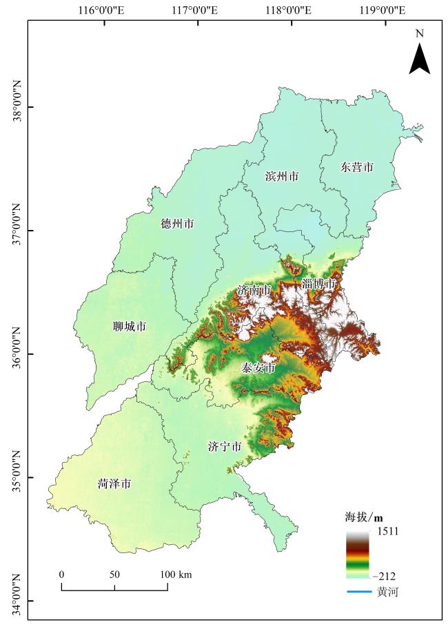
黄河流域山东段处于黄河下游(图1),全长628 km,流域面积1.83万km2,涉及东营市、滨州市、德州市、淄博市、济南市、聊城市、泰安市、济宁市和菏泽市共9个地级市,2020年总人口达到5 768.35万人,城镇化率为57.78%。研究区属温带季风性气候,多年平均降水量为676.5 mm,60%~70%集中于夏季。中部泰山山脉凸起,林地和草地覆盖率高,在维护区域生态安全方面起着重要作用,是维系山东省生态平衡、抵御生态风险的重要生态屏障;西南、西北广阔的平原是重要的粮食作物生产基地。该区域涉及济南都市圈,还包括鲁中南山地丘陵重要生态屏障和鲁西平原重要粮食生产基地,面临高质量发展、生态环境保护与粮食安全的多重压力,土地利用竞争与冲突日益凸显。
1.2 数据来源
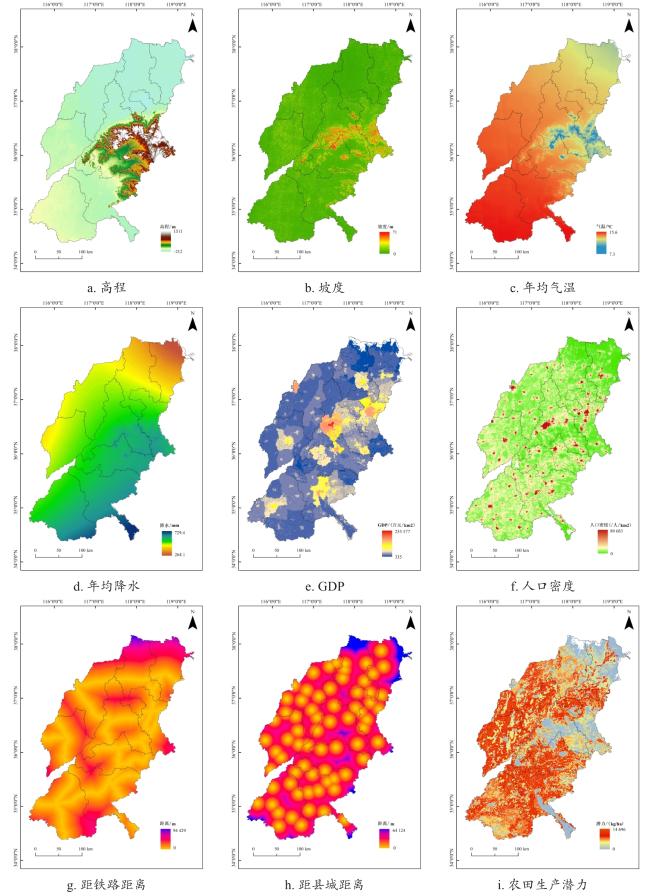
本研究所需数据主要包括土地利用数据、高程数据、基础地理信息数据、气象数据、保护区数据和社会经济数据(表1)。其中,土地利用、GDP(Gross Domestic Product)、自然保护区和农田生产潜力数据来源于中国科学院资源与环境数据平台(https://www.resdc.cn/);高程数据来源于地理空间数据云(http://www.gscloud.cn/),并用于制作相应的坡度图;基础地理信息数据包括行政区界线、县城(区)位置和铁路数据,下载于国家基础地理信息中心(http://www.ngcc.cn);气象数据来源于国家气象科学数据中心(http://data.cma.cn),包含年平均气温和年平均降水数据;人口密度数据来源于Worldpop(https://www.worldpop.org/)。
表1 研究数据来源Table 1 Research Data sources |
| 类别 | 数据 | 分辨率 | 数据来源 |
|---|---|---|---|
| 土地数据 | 土地利用数据 | 30 m | 中国科学院资源与环境数据平台 |
| 农田生产潜力数据 | 1 km | 中国科学院资源与环境数据平台 | |
| 高程数据 | 高程、坡度 | 1 km | 地理空间数据云 |
| 基础地理信息数据 | 行政区界线、县城(区)位置、铁路数据 | 矢量 | 国家基础地理信息中心 |
| 气象数据 | 年平均气温、年平均降水 | 1 km | 国家气象科学数据中心 |
| 限制因子 | 自然保护区数据 | 矢量 | 中国科学院资源与环境数据平台 |
| 社会经济数据 | GDP栅格化数据 | 1 km | 中国科学院资源与环境数据平台 |
| 人口密度数据 | 1 km | Worldpop |
2 研究方法
2.1 土地利用冲突测度模型构建
在景观生态学中,生态系统的结构和组成可以反映不同的土地利用方式和强度所产生的生态影响,而生态系统的景观格局又会直接影响生态学过程[25]。因此,人类活动过于频繁干扰到土地生态系统时,其空间格局会发生变化,进而影响区域生态安全。这也是土地利用冲突在空间结构上的一种表现,因此土地利用冲突强度的大小可通过区域生态安全风险的高低来反映。由于黄河流域山东段特殊的地理位置和重要的生态功能,本研究从景观生态风险评价视角出发,借鉴“风险源-风险受体-风险效应”景观生态风险评价思想,构建土地利用冲突强度测算模型(图2)。风险源是指对目标区域的生态系统产生不良影响的来源[26],以邻域空间对目标空间的干扰程度为衡量标准,选用外部压力因子作为指标;风险受体指生态系统中受到风险源负面影响的客体[27],以各土地利用类型的脆弱性为衡量标准;风险效应即不同的风险受体面临风险源时呈现的不同反应[27],以土地资源的稳定性为指标。一般来说,土地利用冲突强度与由土地利用变化引发的生态风险成正比,参考以往研究中土地利用冲突测算方法[19, 25, 28],土地利用冲突指数(Land Use Conflict, LUC)可以表示为公式(1) 。
式中:PI为外部压力指数(Pressure Index);VI为脆弱性指数(Vulnerability Index);SI为稳定性指数(Stability Index)。
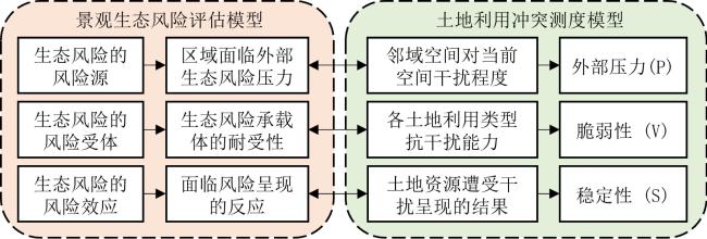
2.1.1 外部压力
式中:AWMPFD为面积加权平均斑块分形指数,取值范围介于1~2;Pij 为斑块周长,km;aij 为斑块面积,km2;A 1为空间单元总面积,km2;n为土地利用类型数量,n=6。
2.1.2 脆弱性
式中:si 为各景观类型的面积,km2;A 2为移动窗口的总面积,km2;fi 为各类用地景观的脆弱性,根据研究区多年来土地利用变化趋势、结合其区域特点和发展战略方向,建设用地、林地、草地、耕地、水域和未利用地分别赋值为1、2、3、4、5和6。
2.1.3 稳定性
式中:PD为斑块密度;ni 为斑块数目。
景观格局指数的计算对粒度和尺度较为敏感,考虑研究区范围、数据分辨率等情况,参考相关研究中格网大小确定方法[29, 30]选取3 km×3 km的移动窗口网格进行测算,能充分地保留土地利用/覆被信息,通过对10、30、50和100 m 的粒度进行调试,对比不同景观粒度下常用景观指数变化情况,发现30 m时各项景观指数出现显著转变,部分指数呈稳定态势,该粒度设置能够有效降低景观信息损失,因此本研究最终选择30 m的粒度。为方便计算,将外部压力指数、脆弱性指数和稳定性指数分别标准化处理至(0,1),代入公式(1) 中计算各空间单元的土地利用冲突指数并将最终结果标准化至(0,1)。最后将土地利用冲突指数划分为三级,即低冲突(0~0.5]、中冲突(0.5~0.7]和高冲突(0.7~1)。
2.2 土地利用多情景模拟
2.2.1 CA模型
CA中每个特定的元胞状态由元胞本身及其邻域在前一时刻的状态通过预定义的转化规则来确定,是一种时间、空间和状态都离散的模型,如公式(6) 所示。
式中:S ( t+ 1) 、S ( t )为时刻t+1、t的元胞状态集合;f为元胞转化规则;N为元胞的邻域。
2.2.2 Markov模型
式中:S ( t+ 1) 、S ( t )为时刻t+1、t的土地利用状态; P ij 为状态转移概率矩阵。
P ij 状态转移概率矩阵可以表示为公式(8) 。
式中:n为土地利用类型的数量,本研究为6类。
2.2.3 情景设置
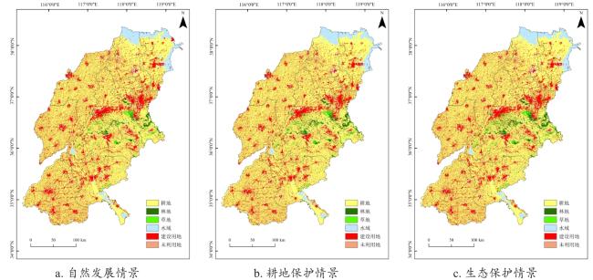
1)自然发展情景。自然发展情景即各景观类型在不受任何外界因素干预的前提下,依据自身历史演变脉络,以线性方式推进的土地利用发展模式,这一情景构建于理想状态的框架下。研究核心假设在于历史时期形成的增长模式在未来数十年内保持稳定延续,故模拟实验中排除了政策法规约束、空间规划引导及市场干扰等限制条件,最大程度还原景观自然演替的本真状态。基于Markov计算得到2030年黄河流域山东段各土地利用类型的变化量。
3)生态保护情景。黄河流域是中国重要经济地带,但面临着生态系统脆弱、环境污染积重较深等突出问题,特别是黄河流域山东段入境水量减少,断流次数增加,给山东经济社会发展和生态环境带来的危害较大[48]。《纲要》特别强调要推进下游湿地保护和生态治理;《规划》提出要筑牢鲁中南山地丘陵生态屏障,保育沿黄河生态带。因此,生态保护情景下,严格保护生态用地,将湖泊和湿地等连片的生态功能显著用地限制转移,本研究将林地转换到其他用地类型的概率减少10%,耕地、建设用地转换到林地的概率增加10%,未利用地转换到林地的概率增加50%。
2.2.4 模型精度验证和参数设置
本研究以黄河流域山东段2000年和2010年的土地利用数据为基础,模拟2020年的土地利用状况,将模拟结果与2020年真实土地利用数据进行对比,Kappa系数达到0.86,表明模型精度很高[20],可以用于黄河流域山东段未来不同情景下土地利用状况的模拟。
本研究运用CA-Markov模型对景观格局进行预测,根据ArcGIS软件计算所得的2000—2010年各景观类型的转移矩阵作为Markov状态转移矩阵的元素,然后建立CA转换规则,由于预测基期土地利用图为2020年的,模拟目标为2030年,因此设置模拟时间为10年,其中CA滤波器选取系统所默认的元胞周围为5×5的矩阵。
3 结果分析
3.1 土地利用变化时空特征
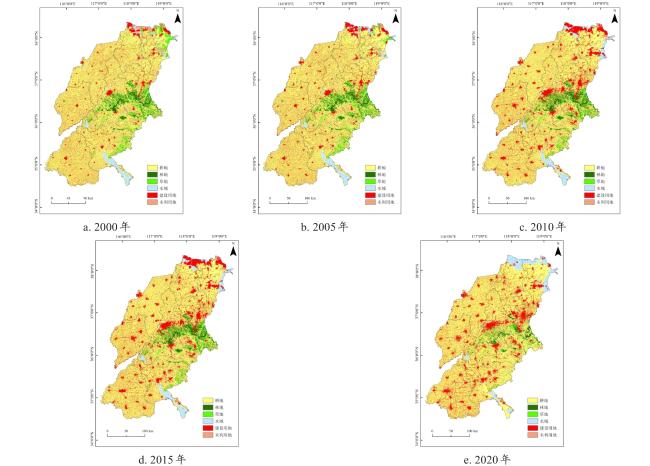
如图4所示,2000—2020年,耕地是黄河流域山东段最主要的土地利用类型。研究期间,黄河流域山东段土地利用变化显著,主要表现为建设用地快速扩张和草地、耕地的减少。具体而言,建设用地增加了4 346 km2,所占比例由2000年的13.50%增长到2020年的18.67%,共增加5.17个百分点,主要是快速城镇化进程中城镇人口的激增以及工业化的快速发展导致对建设用地的需求大增;草地面积减少1 923 km2,其中1 057 km2转为耕地,其中,泰安和淄博等鲁中山地丘陵地区草地转出最为明显,到2020年草地所占比例仅为3.37%;耕地面积减少1 790 km2,其中被建设用地扩张占用较多,占耕地转出面积的87.83%。
3.2 2000—2020年土地利用冲突时空特征
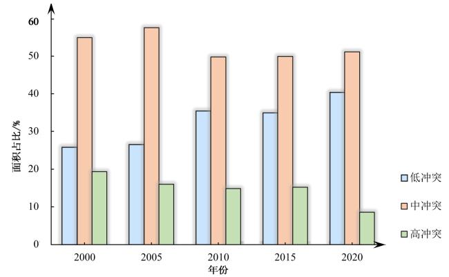
根据土地利用冲突测度模型得到2000—2020年黄河流域山东段土地利用冲突,如图5所示,黄河流域山东段土地利用冲突整体呈减缓态势,土地利用冲突指数均值由2000年的0.567逐渐减小为2020年的0.522,该阶段内中国由高速发展阶段迈入高质量发展阶段,土地利用方式由粗放转向节约集约,因此土地利用冲突整体呈减缓态势。中冲突一直是黄河流域山东段土地利用冲突的主导类型,其次为低冲突,高冲突所占比例最少,这表明黄河流域山东段土地利用冲突整体处于可控状态。土地利用高冲突的比重逐步减少,由2000年的19.34%减少到2020年的8.61%;土地利用低冲突占比逐渐增加,在2020年达到40.28%;土地利用中冲突所占比例在50%上下波动。
2000—2020年,黄河流域山东段土地利用冲突的空间格局基本保持稳定,低冲突主要分布在耕地、水域集中连片度较高地区,以及城市建成区;中冲突分布最为广泛,尤其是耕地与农村居民点之间以及耕地与林地之间的过渡地带(图6)。
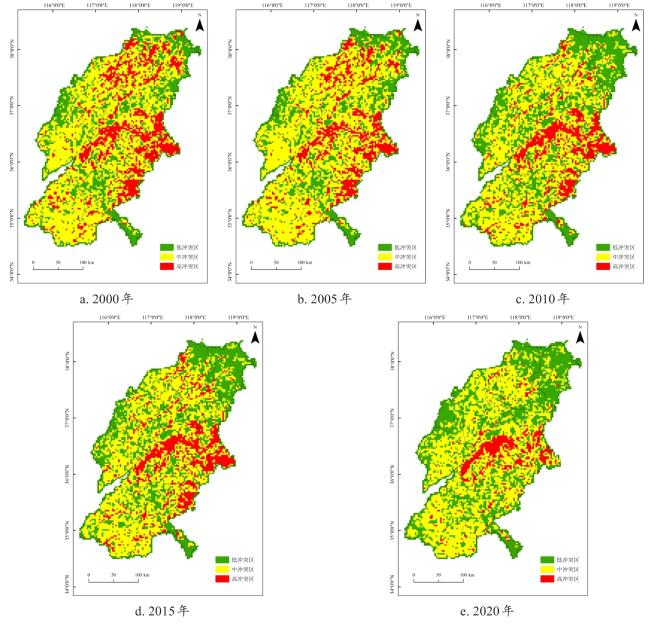
高冲突则呈现块状或带状空间集聚模式,主要分布在以下区域:1)建设用地与其他土地利用类型交界地带。2000—2010年城市建设用地不断扩张,甚至蔓延,侵占周围的耕地、林地和草地,城市建成区周边是土地利用高冲突的主要集聚区。2010—2020年,城市建成区周边高冲突有所减少,但农村居民点周围土地利用冲突程度依然较高,这主要是由于该阶段城镇化和工业化水平较高,城镇建设用地扩张速度有所减缓,而农村居民点仍处于人减地增的粗放发展态势;2)耕地、草地与林地交错带。黄河流域山东段中部有泰山,东部有鲁山、博山等山脉,山地丘陵地区耕地占补平衡实现压力较大,再加上进城务工等导致大量劳动力流失,“耕地上山,林地下山”等现象频发,耕地与生态用地资源错配,空间破碎化、稳定性差,土地利用冲突指数较高;3)黄河沿岸。水资源对农业生产、工业发展具有重要作用,山东省作为北方水资源匮乏地区,在黄河沿岸水资源丰富区域土地竞争激烈,高冲突沿黄河两岸带状分布。
3.3 2030年土地利用冲突模拟预测
3.3.1 土地利用多情景模拟
表2 2030年不同情景下黄河流域山东段模拟土地利用变化情况 ( km2)Table 2 Simulation land use changes in the Shandong section of the Yellow River Basin under different scenarios in 2030 |
| 类别 | 2020年 | 自然发展情景 | 耕地保护情景 | 生态保护情景 | |||
|---|---|---|---|---|---|---|---|
| 面积 | 面积 | 变化幅度 | 面积 | 变化幅度 | 面积 | 变化幅度 | |
| 耕地 | 59 199.81 | 58 695.93 | -503.87 | 59 875.69 | 675.88 | 58 713.27 | -486.54 |
| 林地 | 1 788.25 | 1 064.09 | -724.16 | 1 423.35 | -364.90 | 1 703.89 | -84.36 |
| 草地 | 1 233.09 | 886.37 | -346.72 | 1 002.42 | -230.67 | 1 045.05 | -188.04 |
| 水域 | 4 470.62 | 4 742.39 | 271.77 | 4 596.95 | 126.33 | 4 682.60 | 211.97 |
| 建设用地 | 15 775.92 | 17 086.20 | 1 310.27 | 15 570.95 | -204.97 | 16 322.24 | 546.32 |
| 未利用地 | 52.67 | 36.18 | -16.49 | 41.80 | -10.86 | 44.11 | -8.55 |
3.3.2 不同情景下土地利用冲突
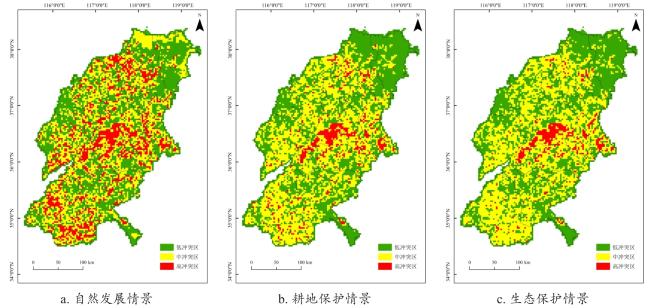
黄河流域山东段不同情景下土地利用冲突格局既有一定共性,也表现出一定差异(图8)。共性方面,2030年三种情景下的土地利用冲突空间分布格局与2000—2020年基本一致,整体呈现出城镇建设用地周边的城乡过渡地带以及鲁中山地丘陵地区的耕林草交错带冲突高的基本特征,这证实了土地利用冲突受制于自然环境等本底影响,土地利用冲突演化过程具有一定路径依赖性和滞后性[19]。差异在于,自然发展情景下冲突形势最为严峻,高冲突分布更为广泛,占比达到17.63%,增加的区域主要为城市建设用地和农村居民点周围,中冲突占比减少到39.20%,该情景下仍按照历史轨迹发展演进,没有采取有效措施调解土地利用冲突,建设用地扩张、耕地保护与生态保护矛盾突出。耕地保护情景下,低冲突有所增加,所占比例为46.9%。生态保护情景中,土地利用冲突控制效果最好,低冲突增多,高冲突所占比例为5.44%,该情境下,坚持生态保护优先原则,把生态环境保护放在突出位置,有效遏制了建设用地扩张和耕地开垦等对生态环境的破坏,有效缓解了不同土地利用类型之间的空间竞争。
3.4 不同情景下土地利用冲突缓解效果
基于黄河流域山东段近二十年的土地利用冲突水平和不同情景下的模拟结果,分别绘制出高冲突占比和中高冲突占比的变化趋势(图9),以此为依据评估不同情景下土地利用冲突的缓解效果。从高冲突占比来看,自然发展情景下由于没有对用地类型之间转换作任何限制,大量耕地被侵占转化为建设用地,高冲突区域呈现无序蔓延状态。耕地保护情景和生态保护情景下的模拟结果要优于自然发展情景,相比2020年高冲突占比均略有下降,高冲突区域得到有效遏制,其中生态保护情景下土地利用高冲突缓解效果最为显著。
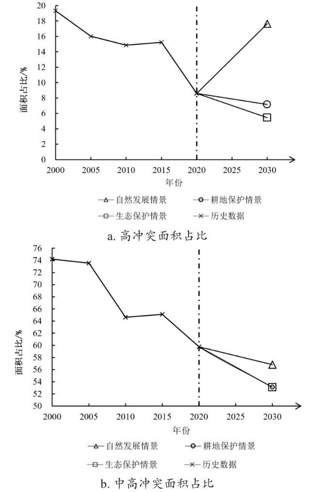
从中高冲突占比来看,三种情景均呈现下降趋势,耕地保护情景和生态保护情景的变化曲线趋近于重合状态。自然发展情景下,中高冲突占比变化与高冲突占比变化则完全相反,这表明虽然自然发展情景下高冲突占比急剧上升,但整体冲突程度并未提高,这与低冲突区域增多有关。由于模拟中土地适宜性的选择,耕地保护情景中耕地连片度提升,避免土地利用过于破碎,土地利用格局更趋于稳定,冲突局面有所缓解。生态保护情景中,由于限制性条件的约束,有效保障生态空间,生态格局更加优化,冲突形势有所降低。
综合来看,自然发展情景下将导致耕地、林地和草地大面积的破坏,建设用地总量超过规划面积,耕地与建设用地之间的矛盾将成为阻碍人口增长和社会发展的关键问题,高冲突占比的上升还会破坏人地关系,显然不符合未来发展理念;耕地保护情景下有效保护了耕地资源,保障了国家粮食安全,但耕地面积增长是以牺牲生态空间为代价的,尤其是济南市、泰安市和淄博市大量林地被侵占,对区域生态环境影响显著;生态保护情景下,耕地总量控制在合理范围内,同时林地、草地和水域此类具有重要生态功能的地类得到了严格保护,鲁中山地丘陵地带林地覆盖率提高,对保障区域生态安全至关重要。此外,生态保护情景下的土地利用状况不仅能满足经济发展所带来的建设用地增长需求,更能协调好耕地保护和生态保护之间的关系,高冲突占比最低,是未来可持续发展的最优方案。在未来发展中应严格限制人为破坏生态空间,控制新增建设用地规模,提高存量建设用地利用效率,通过集中连片等方式提高耕地产出效益,大力建设高标准农田,统筹配置耕地保护、生态安全和经济发展可持续的土地利用策略。
4 结论与展望
本研究采用景观格局指数构建土地利用冲突测度模型,定量刻画了2000—2020年黄河流域山东段土地利用冲突时空格局,进而结合CA-Markov模型模拟了2030年多情景下潜在土地利用冲突,结论如下。
1)2000—2020年黄河流域山东段土地利用类型以耕地为主,建设用地在城镇化建设中快速扩张,所占比例提高了5.17个百分点,并以占用耕地为主。
2)2000—2020年土地利用冲突程度有所减缓,高冲突比例逐步减少到8.61%,低冲突占比逐渐增多,中冲突占比稳定在50%左右。高冲突在鲁中山地丘陵用地类型交错带、建设用地周边呈块状聚集,在黄河沿岸带状分布。
3)自然发展情景下冲突有恶化趋势,高冲突所占比例达到17.63%,建设用地增长与耕地减少之间的矛盾会威胁粮食安全,加剧人地矛盾,不符合未来发展理念;耕地保护情景下,冲突程度有所减缓,高冲突占比减少,但耕地增长是以牺牲生态空间为代价,不利于区域生态安全;生态保护情景下,高冲突占比最低,土地利用冲突缓解效果最为显著,更能平衡耕地数量、生态安全和城镇化发展三者之间的关系,是未来十年土地利用可持续发展的最优情景。
本研究仍存在一些待改进之处。首先,研究中的土地利用冲突测度模型强调土地利用空间结构冲突,属于显性冲突的范畴,忽视了土地利用功能冲突等隐性冲突。其次,参考相关研究,受限于数据获取等因素的限制,仅设置了自然发展、耕地保护和生态保护三种情景。今后研究中,一方面可进一步结合宏观发展阶段、新发展理念等合理设置发展情景。另一方面,加强区域特色情景设置,例如,针对黄河三角洲等地区设置盐碱地治理情景等,以提高实际应用价值。最后,精准模拟未来土地利用空间格局是合理预测潜在土地利用冲突的重要前提,预测精度对土地利用冲突有一定影响,未来研究应进一步加强多种模拟预测方法的比选,提高预测精度。


