


0 引 言
农业灾害防控作为全球粮食安全体系的核心环节,在气候变化导致极端天气事件频发的背景下日益凸显其重要性[1, 2]。近年来,全球范围内干旱、洪涝、高温、冻害等气象灾害的发生频率和强度显著上升,对农业生产造成了严重威胁[3, 4]。据联合国粮食及农业组织报道,南苏丹在2024年因连续洪水影响,导致超过700万人面临严重粮食不安全状况,这反映了气象灾害对农业生产的巨大破坏力。为应对这些挑战,各国政府和国际组织积极采取措施,如中国农业农村部会同水利部、应急管理部、中国气象局在2024年主汛期联合印发了《科学应对汛期自然灾害奋力夺取粮食和农业丰收预案》,细化实化了灾情防控关键措施,体现了国家对农业气象灾害防控的高度重视。
在技术层面,现代对地观测技术的进步为农业气象灾害监测预警提供了全新解决方案。当前已形成卫星、无人机、地面观测相结合的“天空地”一体化立体观测网络。卫星平台如Sentinel-2、Landsat系列和中国的高分专项工程等,可提供广覆盖、周期稳定的区域尺度监测数据[5];无人机平台凭借其机动灵活的特性,能够获取厘米级分辨率的农田精细信息;地面传感网络则通过持续监测土壤、小气候等参数,为遥感反演提供地面真值验证[6]。这些平台搭载的光学、热红外和微波等传感器各具特色,光学传感器擅长捕捉植被光谱特征,热红外传感器可准确反演地表温度,微波传感器则具有穿透云层和部分植被的能力,共同形成了多维度、全谱段的协同观测能力[7]。从方法论角度看,农业气象灾害遥感监测预警已发展成系统化的技术体系,这一体系起源于多源遥感数据的智能处理与特征提取,通过物理模型与机器学习方法的结合,将原始观测数据转化为具有农学意义的作物生长参数[8]。进而基于过程模型与数据驱动模型,实现对灾害发生发展规律的动态模拟与趋势预测,最终通过决策优化算法将预警信息转化为差异化防控方案,形成从感知到决策的完整闭环[2, 3]。这种方法论框架使农业灾害管理从传统灾后应急响应向事前风险预警、事中精准调控转变。需要指出的是,“高时空分辨率”并非单纯追求更细的像元或更密的重访,而是指在灾害快速演变与作物异步生长的背景下,观测体系能够在田块尺度刻画空间异质性并在“小时—日”尺度捕捉过程突变的综合能力。相较于传统的中低分辨率遥感(以“百米—千米”空间尺度、“周—旬”时间尺度为主),高时空分辨率观测可显著改善三类关键问题:其一,降低混合像元对灾情识别阈值的钝化效应,使灾害边界与受害强度梯度更可分;其二,提高对短历时事件(如骤发洪涝、干热风、冰雹、倒伏)的可观测性,减少“错过窗口”的信息缺口;其三,为“监测-预警-决策”的闭环系统提供更高频的状态更新,从而支撑滚动预报与干预效果评估。与此同时,高时空分辨率也带来更突出的数据同化、计算成本与跨尺度一致性挑战,因而其价值必须在“观测-模型-决策”的系统框架中被讨论与实现。
就灾害类型而言,本文聚焦于由气象因素直接引起的水文胁迫、温度胁迫和结构破坏三类灾害。水文胁迫主要包括干旱和洪涝,其发生过程具有明显时空异质性,需要借助多源遥感数据捕捉动态变化特征[9, 10]。温度胁迫包括高温热害和低温冻害,这类灾害发生突然、影响直接,对监测预警时效性要求极高[11, 12]。作物倒伏作为典型的机械结构破坏,其发生机制涉及气象、栽培和作物生理等多因素耦合,需要通过多平台协同观测才能实现准确预警[13-15]。本文未将病虫害等生物灾害纳入讨论范畴,主要是由于病虫害的发生虽然与气象条件相关,但其发生机制、传播途径和预警方法与传统气象灾害存在本质区别。病虫害涉及生物与环境、寄主的复杂互作关系,监测预警需要结合病原菌孢子捕捉、昆虫迁飞轨迹预测等专门技术[16-18],超出了本文聚焦气象致灾因子直接影响的讨论范围。
本文系统梳理了“天空地”一体化遥感技术在农业气象灾害监测预警领域的最新进展,通过总结多平台传感器的技术特点与应用场景,分析了水文胁迫、温度胁迫和结构破坏三类灾害的监测预警技术路径,探讨了监测预警决策闭环构建中的关键科学问题。研究旨在为构建智能化、精准化的农业气象灾害防控技术体系提供理论参考,为提升农业防灾减灾能力提供技术支撑。
1 “天空地”一体化的农业遥感观测体系
现代精准农业灾害管理的效能提升,在很大程度上得益于多层次、多尺度立体感知网络的建设与发展。这一网络体系(图1)通过整合卫星遥感、航空与无人机遥感,以及地面物联网观测系统,综合利用光学、微波、热红外乃至激光等不同原理的传感器,构建起了从区域范围的“千米”级宏观监测到田间尺度的“厘米”级精细观测的全方位技术能力。这种天空地协同的观测架构,为实现农业灾害的全过程、多要素精准监测提供了坚实的技术基础。
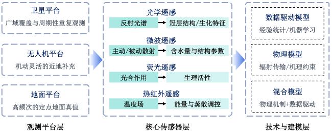
1.1 平台维度: 互补的观测生态位
在平台架构方面,现代农业遥感形成了层次分明、功能互补的体系格局。卫星平台以其广域覆盖和周期性重复观测的特点,成为区域至全球尺度农业灾害监测的核心力量[19]。其中,中高分辨率光学星座如Sentinel-2、Landsat系列,以及中国的高分专项卫星,能够提供丰富的植被光谱信息,支撑作物长势、生物量估算和叶绿素含量反演等应用[20-22]。合成孔径雷达(Synthetic Aperture Radar, SAR)凭借其全天时、全天候的工作能力,在对土壤水分动态、作物结构变化,以及洪涝灾害监测方面展现出独特优势[23, 24]。近年来迅速发展的商业遥感星座,如PlanetScope和SkySat等,更进一步将时间分辨率提升至近每日水平,为捕捉快速演变的灾害过程创造了条件[25, 26]。然而,卫星平台仍面临着空间分辨率与时间分辨率之间的固有权衡,且光学观测易受云、雨等气象条件制约。
无人机平台作为卫星观测的重要补充,以其独特的机动灵活性填补了不同尺度间的观测空白[3]。通过搭载多光谱、高光谱相机,无人机能够实现对田块内部植被参数异质性的精准刻画[27-29]。配备热红外传感器则可获取高精度的冠层温度分布图,为水分胁迫和温度胁迫诊断提供关键数据[29, 30]。而轻小型激光雷达(Light Detection and Ranging, LiDAR)系统的应用,使得直接获取作物冠层三维结构信息成为可能,这对监测倒伏、估算生物量具有重要意义[31, 32]。尽管无人机平台在覆盖范围、空域管制和数据处理方面仍存在一定限制,但其在农田尺度的精细观测能力已使其成为现代农业遥感体系中不可或缺的组成部分。
综上,平台协同的关键不在于“多平台并列”,而在于通过时空配准、质量控制与任务分工,使观测结果可直接服务于监测预警模型的状态更新与决策系统的可执行单元。
1.2 传感器维度: 差异化的信息获取能力
在传感器技术层面,不同电磁波谱段的探测能力为农业灾害监测提供了多元化的信息维度。光学遥感作为发展最为成熟的技术体系,基于地物对太阳光的反射和自身热辐射特性,在可见光-近红外-短波红外波段支持植被指数计算、生物物理参数反演和土地利用分类等广泛应用[37-39]。其中,热红外波段通过对地表温度和蒸散发的估算,成为监测干旱和温度胁迫的核心技术手段[40-42]。然而,光学遥感难以穿透云层且观测能力受限于昼夜条件,在一定程度上推动了其他探测手段的发展与应用。微波遥感,特别是SAR技术,通过主动发射微波信号并接收地物后向散射回波,或者被动接收地物自身的微波辐射,实现了对地表特征的另一种感知维度。其对地表粗糙度、介电常数的高度敏感性,使其在土壤水分监测方面具有不可替代的优势。同时,微波与作物结构的相互作用机制,也为株高、生物量等结构参数估算提供了独特的数据源[43-45]。虽然微波遥感数据的物理解读相对复杂,且易受射频干扰影响,但其全天时、全天候的观测能力完美弥补了光学遥感的不足。荧光遥感作为新兴探测技术,通过捕捉植物光合作用过程中产生的叶绿素荧光信号,为作物生理状态监测开辟了全新的途径[46, 47]。由于太阳诱导叶绿素荧光与植物光合作用过程具有直接联系,使其能够比传统植被指数更早、更直接地反映作物的胁迫状态[48]。在干旱胁迫早期诊断、光合效率评估等方面,荧光遥感展现出巨大潜力,尽管其信号微弱、探测技术要求高,但作为反映作物生理功能的直接指标,正逐渐成为农业遥感前沿研究的热点[49-51]。热红外遥感则专注于地表能量平衡过程的监测,通过探测地表的热辐射特性,精确反演地表温度参数[41, 42]。这一技术不仅为高温热害和低温冻害的识别提供直接依据,更重要的是通过蒸散发估算,揭示作物的水分胁迫状况[52-54]。与荧光遥感形成互补的是,热红外遥感从能量平衡角度反映作物功能状态,而荧光遥感则从光合生理角度提供信息[55, 56],二者共同构成了作物生理生态监测的技术体系。
因此,多平台、多传感器的协同观测并非简单的信息叠加,而是通过不同电磁波段在结构、功能与能量过程层面的互补感知,构建对作物灾害状态的多维约束。光学、微波、热红外与荧光遥感分别从冠层结构、水分条件、能量平衡与光合功能等不同机理刻画作物响应,为灾害监测提供相互验证的观测证据。这种基于物理机理互补的协同观测体系,是实现灾害状态可靠识别、降低单一传感器不确定性并支撑后续预警与决策建模的关键技术基础。
2 灾害遥感监测、预警与决策机制
农业灾害的精准防控离不开完善的技术体系支撑。随着遥感技术的快速发展,农业灾害管理已从单一的数据解译发展为涵盖监测、预警与决策的完整技术链条。这一体系通过将原始遥感观测数据转化为具有农学意义的生物物理参数,进而实现对灾害过程的动态模拟与风险预测,最终形成可执行的防控方案,构成了一个从感知到认知再到行动的完整技术闭环(图2)。
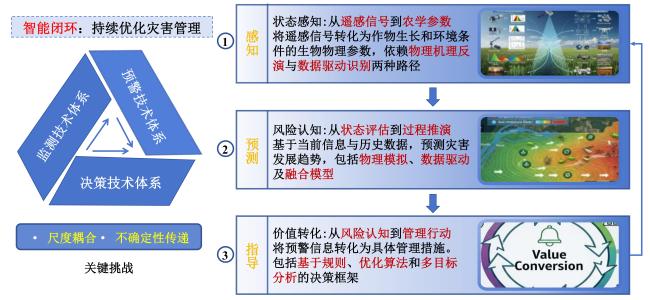
2.1 监测技术体系:从遥感信号到农学参数的状态感知
监测技术体系的核心在于将遥感获取的电磁波信号转化为反映作物生长状态和环境条件的生物物理参数。这一转化过程主要依赖两类技术路径:物理机理驱动型反演与数据驱动型识别。
物理机理驱动型反演基于电磁波辐射传输、能量平衡等物理定律,通过构建前向模型并求解反问题来获取目标参数[57, 58]。这一领域已形成较为成熟的理论体系,例如叶片-冠层耦合辐射传输模型(PROSPECT+SAIL, PROSAIL)模型族通过耦合叶片光学模型与冠层反射模型,实现了从光学遥感数据中反演叶面积指数和叶绿素含量[59, 60];基于能量平衡方程的单通道、分裂窗算法为热红外数据反演地表温度提供了理论支撑[61, 62];而水云模型、改进积分方程模型(Advanced Integral Equation Model, AIEM)等物理模型则成功应用于SAR数据估算地表土壤水分[63, 64]。国内外学者在这些领域进行了深入研究,研发了多种优化算法以提升反演精度和效率。这类方法的优势在于物理基础坚实,反演结果具有明确的物理意义和良好的普适性。然而,其局限性同样明显,复杂的模型结构、对先验知识的依赖,以及对数据质量的严格要求,都在一定程度上制约了其业务化应用的广度。
相比之下,统计与机器学习驱动型识别则采用了不同的技术路线。该方法绕过复杂的物理过程,直接从数据中学习遥感特征与地面实测参数之间的统计关系或复杂映射[65, 66]。从早期的植被指数计算,到基于随机森林、支持向量机等传统机器学习方法的特征工程,再到当前基于深度学习的端到端模型,这一技术路线在不断演进。卷积神经网络在灾害识别中的成功应用[67, 68],U-Net在语义分割中的卓越表现[69, 70],以及生成对抗网络在数据融合与超分辨率重建中的潜力[71, 72],都展示了数据驱动方法的强大能力。特别值得一提的是,近年来众多研究团队致力于开发专门针对农业遥感任务的深度学习架构,在作物倒伏识别、干旱监测等方面取得了显著进展[73-75]。这类方法的优势主要体现在其对复杂非线性关系的高效表征能力,以及灵活可扩展的模型结构;但其“黑箱”特性导致的可解释性缺失,以及对训练数据质量和数量的强依赖性,仍然是亟待解决的关键问题。同时,农业灾害领域长期缺乏公认的、跨区域跨年型的标准化基准数据集与统一评测协议,导致不同研究在数据源、标注标准与评价指标上难以对齐,限制了深度学习模型的可重复验证、横向可比与快速迭代。
2.2 预警技术体系: 从状态评估到过程推演的风险认知
预警技术体系的核心任务是基于当前监测信息与历史数据,对灾害发展趋势进行科学预测。当前主流的预警技术可分为基于物理机制的模拟模型、基于数据驱动的预测模型,以及二者融合的混合模型三大类。
基于物理机制的模拟模型对作物生理生态过程、土壤水文循环等自然过程的数学描述,构建数值模拟系统。作物生长模型如农业技术转移决策支持系统(Decision Support System for Agrotechnology Transfer, DSSAT)、AquaCrop等能够模拟不同环境条件下作物的生长发育过程[76, 77],土壤-植物-大气连续体模型可以精确描述系统中的能量与物质交换[78],分布式水文模型则为洪涝过程的模拟提供了有效工具[79, 80]。这些模型具有机理清晰、外推能力强的特点,在情景分析和机理研究中具有不可替代的价值。然而,复杂的参数化方案、高昂的计算成本,以及对输入数据完整性的严格要求,限制了其在实时预警中的应用效果。
2.3 决策技术体系:从风险认知到管理行动的价值转化
决策技术体系承担着将预警信息转化为具体管理措施的关键任务。根据决策过程的自动化程度和复杂性,现有决策技术可分为基于规则的决策引擎、基于优化的决策算法和基于多目标分析的决策框架等不同类型[90, 91]。基于规则的决策引擎通过预设的逻辑阈值和条件判断,实现快速的灾害响应。这类系统通常建立在领域专家知识的基础上,采用“IF-THEN”的逻辑结构,具有实现简单、响应快速的优点,在霜冻预警灌溉、干旱预警补水等场景中得到广泛应用[92]。然而,规则的刚性特质使其难以适应复杂多变的生产环境,缺乏对系统整体优化的考虑。基于优化的决策算法则通过建立数学模型,在满足各种约束条件的前提下,寻求最优的灾害应对方案。线性规划、动态规划等数学规划方法在灌溉水资源优化分配中发挥着重要作用[93]。遗传算法、粒子群算法等进化算法在复杂的非线性优化问题中展现出独特优势[94, 95]。这类方法能够从系统整体角度寻求最优解,但往往对模型精度和计算资源有较高要求。多目标决策分析框架则针对农业管理中常见的多目标冲突问题,提供了系统的解决方案[90, 96]。在面对经济效益与环境保护、短期收益与长期可持续性等目标冲突时,帕累托最优等概念和方法为决策者提供了科学的分析工具[97, 98]。这类方法承认决策过程中的价值判断因素,通过明确的权衡机制支持决策者的选择,更符合实际生产中的复杂决策环境。
2.4 “监测-预警-决策”的辩证统一关系
监测、预警与决策三个环节并非简单的线性关系,而是构成一个动态反馈、相互依存的有机整体。从信息流动的角度看,监测承担“感”的职能,解决“是什么”的问题;预警承担“知”的职能,解决“将怎样”的问题;决策承担“行”的职能,解决“怎么办”的问题。信息的价值和知识密度在这一过程中逐级提升,形成明显的层级递进关系。更为重要的是,这三个环节构成了一个动态反馈的闭环系统。决策行动的实施效果会改变农田系统的状态,这种状态变化被监测系统捕获后,形成反馈信息用于验证预警准确性、评估决策有效性,并进一步优化预警模型与决策规则。这种自适应学习机制是系统智能化的核心体现,使得整个技术体系具备持续改进的能力。
尺度耦合问题是贯穿技术链条的关键挑战。监测环节的“像素级”粒度、预警环节的“田块/区域级”尺度与决策环节的“田块/农场级”单元之间存在固有的尺度差异。如何实现不同尺度间的信息转换与无损传递,确保监测精度不损失、预警范围恰当、决策单元可执行,是技术体系设计必须考虑的核心问题。不确定性传递现象则对技术可靠性提出了更高要求。从数据获取、参数反演到模型预测、方案制定,每个环节都会引入不确定性,这些不确定性沿着技术链条传递并可能被逐级放大。建立系统性的不确定性量化方法与消减策略,发展鲁棒性强的算法模型,是保障最终决策科学性的重要基础。这种辩证统一关系要求研究人员在技术研发和系统设计中,必须打破传统“碎片化”的思维模式,以系统工程的视角统筹考虑三个环节的技术选型与集成方案,唯有如此才能充分发挥“天空地”一体化观测体系的技术潜力,实现农业灾害管理的精准化与智能化。
3 灾害类型深度剖析: 技术应用与系统挑战
在农业灾害管理领域,高时空分辨率遥感技术的应用正从单一灾害监测向多灾害协同预警方向深化发展。本章从灾害系统理论出发,整合“天空地”一体化观测数据,对水文胁迫、温度胁迫、结构破坏及复合灾害进行结构化剖析,系统阐述各类灾害在监测、预警与决策环节的技术路径与核心挑战。
3.1 水文胁迫灾害
3.1.1 干旱
在干旱监测领域,多平台协同观测已成为突破单一数据源局限的有效途径。卫星遥感通过可见光-近红外波段获取的植被指数,如归一化植被指数(Normalized Difference Vegetation Index, NDVI)与热红外波段反演的地表温度,可构建温度-植被指数特征空间,进而推导出归一化差异水体指数(Normalized Difference Water Index, NDWI)[99]、植被状况指数(Vegetation Condition Index, VCI)[100]、温度状况指数(Temperature Condition Index, TCI)[101]、温度植被干旱指数(Temperature Vegetation Dryness Index, TVDI)[102]等综合监测指标。中国气象局兰州干旱气象研究所开发的“西北/中国北方农业干旱监测业务系统”,通过融合风云等多源卫星数据与气象水文资料,建立了气候分区与植被类型耦合的干旱监测优化技术。然而,这些基于地表参量的监测方法仍难以直接捕捉根系层水分动态,而根系层水分才是作物抗旱能力的关键决定因素。
在突破根区土壤水分监测瓶颈方面,多平台协同观测展现出巨大潜力。FU等[103]通过融合高时空分辨率(30 m,1天)的根区降尺度土壤水分数据,构建了土壤水分条件指数(Soil Moisture Condition Index, SMCI),在干旱识别验证中表现出与植被指数变化的高度一致性。微波遥感,特别是土壤水分主动-被动卫星(Soil Moisture Active Passive, SMAP)和Sentinel-1等卫星平台,通过捕捉土壤介电特性与水分含量的物理关联,为表层土壤水分监测提供了全天候解决方案[104]。然而,微波信号在植被覆盖茂密区的穿透能力受限,影响了其在作物关键生育期的监测精度。为解决这一问题,学者尝试将卫星遥感的广域覆盖与地面物联网的精准监测相结合,如基于物联网站点与深度学习模型生成的高精度、高时空连续的土壤水分数据产品[105]。
在干旱预警方面,如何实现从“水分状态监测”到“作物响应预测”的跨越是核心挑战。传统上,基于土壤水分或气象干旱指数的预警方法难以准确预测干旱胁迫对作物生理过程及最终产量的影响。MO等[106, 107]针对重力恢复与气候实验后续卫星(Gravity Recovery and Climate Experiment Follow-On, GRACE/FO)数据存在的约3个月滞后期,开发了基于贝叶斯卷积神经网络(Bayesian Convolutional Neural Network, BCNN)的陆地水储量异常概率预测模型,成功实现了水文干旱的动态近实时监测,纳什效率系数中位数达0.81~0.89,显著提升了干旱早期预警能力。在农业干旱预警中,融合土壤-植物-大气连续体(Soil-Plant-Atmosphere Continuum, SPAC)模型与多源遥感数据成为前沿方向[78]。通过耦合作物生长模型与遥感反演的土壤水分、蒸散发等参数,模拟水分胁迫对作物气孔导度、光合作用等生理过程的影响,从而实现对产量损失的预测性评估[76, 77]。值得强调的是,传统基于光学植被指数的干旱监测更敏感于叶面积、叶绿素与冠层结构等“形态-结构”变化,往往在胁迫进入中后期才出现显著信号;而太阳诱导叶绿素荧光(Solar-Induced Chlorophyll Fluorescence, SIF)与光合作用过程更直接相关,能够在叶片尚未明显黄化、冠层结构尚未显著退化之前,对气孔关闭、光化学效率下降等“生理干旱”响应表现出更早的敏感性。因此,在高时空分辨率框架下,将SIF与热红外冠层温度/蒸散发指标,以及微波土壤水分产品进行互补融合,有望实现从“水分异常”到“作物功能受限”的更早期预警,提高预警的提前量与生理相关性。
干旱决策支持系统面临着水资源约束下的多目标优化挑战。理想的灌溉决策不仅要考虑作物需水规律,还需统筹区域可用水量、灌溉设施能力、经济效益与环境可持续性等多重因素。数字乡村智能监控平台通过整合卫星遥感、地面传感器与水资源调配数据,构建了耕地“一本账”管理系统,为水资源优化配置提供了数据支撑。在实践层面,基于优化算法(如线性规划、遗传算法)的决策模型可在多重约束下生成灌溉方案,而多目标决策分析方法则帮助决策者在经济效益与环境保护等冲突目标间进行权衡。
3.1.2 洪涝
洪涝灾害的突发性与破坏性要求监测系统具备快速响应能力。SAR凭借其全天时、全天候工作优势,成为洪涝范围监测的核心数据源。Sentinel-1、GF-3等SAR星座通过主动微波对地表水体的敏感响应,能够有效穿透云雨障碍,实现淹没范围的快速提取[108]。然而,仅凭淹没范围不足以支撑精细化的灾损评估与应急决策,淹没深度与历时的反演仍是技术难点。当前研究致力于融合SAR数据与高精度数字高程模型(Digital Elevation Model,DEM)来估算淹没范围与程度[109, 110],但DEM的空间分辨率与精度限制影响了反演结果的可靠性。无人机平台在洪涝监测中发挥着重要的补充作用,特别是在卫星过境间隙,可快速获取受灾区域的厘米级分辨率影像,为灾损评估和排涝规划提供精细数据[111]。
洪涝预警的准确性高度依赖于高时空分辨率的降雨-径流预报耦合。目前,气象卫星如风云系列和日本的“葵花”卫星可提供高时间分辨率的降水观测,但与分布式水文模型(如Hydrologic Engineering Center's River Analysis System, HEC-RAS、Soil and Water Assessment Tool, SWAT)的耦合仍存在尺度不匹配问题[79, 80, 108]。短临降雨预报的不确定性会随着水文模型传播放大,导致洪水预见期与量级预测存在偏差。南京大学团队在解决数据时滞问题上取得的进展值得借鉴,其通过贝叶斯卷积神经网络实现数据滞后期水文过程的可靠预测[106, 107],为洪涝预警中的模型耦合提供了新思路。
洪涝应急决策面临极端时效性要求的挑战,从预警信息发布到排涝调度、物资调配的决策链条必须高度压缩。在商业层面,多家数字乡村智能监控平台通过整合遥感监测、视频监控与物联网数据,构建了洪涝灾害的快速响应机制,实现了风险识别、预警发布与应急调度的自动化闭环。在技术层面,基于规则的决策引擎可根据预设的淹没深度阈值自动触发应急响应,但其灵活性不足的问题在复杂灾情中尤为明显。当前研究正探索结合实时监测数据与强化学习算法,构建自适应决策支持系统,以动态优化应急资源配置与排涝方案。
3.2 温度胁迫灾害
3.2.1 高温热害与干热风
高温热害与干热风对作物的影响具有器官特异性与复合性特征,这为遥感监测带来了特殊挑战[112, 113]。在监测方面,热红外遥感可反演冠层温度,但作物生殖器官(如穗部、花器)的温度才是决定花粉育性与结实数量的关键[114]。然而,受传感器空间分辨率与观测角度的限制,遥感难以直接获取器官尺度的温度信息。无人机平台搭载的高分辨率热红外传感器在一定程度上缓解了这一问题,通过近距离观测可获得冠层温度的精细分布,但仍无法完全消除土壤背景与冠层结构的混合像元影响[114]。干热风作为热、干、风三要素构成的复合胁迫,其监测要求同步获取温度、湿度与风速数据[115]。遥感技术可通过热红外波段反演气温近似值,通过微波遥感估算大气可降水量,但对农田小气候风速的直接感知能力仍显不足,需借助地面自动气象站数据进行补充[116]。
3.2.2 低温冻害
3.3 结构破坏灾害
3.3.1 倒伏
倒伏预警的本质是一个多致灾因子耦合的力学建模问题。传统经验模型基于历史倒伏数据与气象因素建立统计关系,缺乏普适性与机理解释性。近年来,机理-数据融合模型成为研究热点,通过结合力学原理与机器学习算法,模拟风、雨荷载作用下作物茎秆的弯曲力矩与抗倒伏能力间的平衡关系[141, 142]。例如,通过利用蒙特卡罗模拟技术生成风速风向、降雨量数据集,构建基于空气动力学的倒伏模型,进而模拟不同气象条件下的作物倒伏情况[142];利用卷积神经网络从多时相遥感数据中提取冠层结构特征,结合有限元分析模拟茎秆在不同风速、降水条件下的应力分布,从而预测倒伏临界条件[141]。然而,这类模型对输入数据质量与计算资源的要求较高,业务化应用仍需进一步优化。
倒伏决策的独特之处在于其强调预防性干预,与灾害发生后的补救措施相比,倒伏的灾前预防往往能够在更低的经济与环境成本下实现更显著的稳产增产效果。这要求倒伏预警模型不能仅停留在对当前生长状态的评估,还必须具备跨生育期的动态预测能力。这种预测并不等同于“播种前遥感直接判断”,而应区分为两个层次,第一层是基于历史倒伏记录、品种抗倒伏性状、土壤养分背景与季节尺度气象预报的“播前—早期”规划,用于确定播量、氮肥策略与密度控制等结构性措施;第二层是在作物出苗成苗后,利用高时空分辨率遥感对冠层结构、生物量与长势空间差异的持续监测,结合短临风雨预报开展滚动预警,从而识别关键田块并优化调控措施(如控旺、化控、排水、支撑等)。此外,考虑到农业生产的区域性与年度间气候波动,理想的决策系统还应具备情景扩展与自适应能力,能够结合实时气象预报与田间监测数据,对预警结论进行滚动修正与本地化校准,从而在多变的生产环境中持续提供精准、可靠的决策支持。因此,构建具备高时效性、强机理性与广适用性的跨生育期倒伏预警-决策体系,不仅是农业遥感与智能栽培研究的核心目标,也是推动作物生产系统走向风险规避型精准管理的必要途径。
3.3.2 冰雹
冰雹灾害是由强对流天气引发的高动能固体降水事件,其对作物造成的损伤以叶片撕裂、茎秆折断、穗部或果实机械破坏为主要特征,具有突发性强、空间尺度小、灾损分布高度斑块化等显著特点,对高时空分辨率遥感监测提出了更高要求。与干旱或倒伏不同,冰雹作用时间极短,遥感在灾前难以直接感知,其核心价值主要体现在灾后快速识别与定量评估。光学遥感可通过植被指数骤降、冠层反射率结构突变,以及纹理特征变化识别受损区域,高分辨率影像在刻画冰雹条带状或斑块状灾损格局方面尤为有效[143, 144]。SAR对冠层结构扰动和含水量变化敏感,在多云多雨条件下可稳定获取灾后信息,为冰雹快速制图提供了重要补充[145]。无人机平台凭借厘米级空间分辨率,在冰雹灾害精细监测中展现出不可替代的优势,可直接观测叶片破碎程度、冠层裸露比例及果实脱落情况,用于构建田块尺度的灾损等级图[143, 146]。然而,冰雹灾害的遥感监测仍面临两方面挑战:一是灾损表征高度依赖影像获取时效,错过关键窗口易导致信号被后续恢复过程掩盖;二是机械损伤与病虫害、倒伏等胁迫在光谱层面的混合响应,增加了灾因判识的不确定性[147]。
冰雹灾害预警的本质并非传统意义上的“遥感预测”,而是一个以强对流发生条件为核心的气象-环境耦合问题,其时间尺度以分钟至小时为主,遥感技术更多承担风险建模与暴露评估的支撑角色。现有冰雹预警主要依赖多普勒天气雷达、数值天气预报和对流参数(如对流有效位能(Convective Available Potential Energy, CAPE)、风切变等)对冰雹发生概率和强度进行判识[148]。在农业应用中,单纯的气象预警难以直接转化为灾害风险评估,因为其未考虑作物生育期差异、冠层结构与器官暴露程度等关键脆弱性因素。近年来,研究开始尝试将高时空分辨率遥感获取的作物类型、生育期与冠层结构参数引入冰雹风险模型,构建“气象危险度-作物暴露度-脆弱性”耦合框架[147]。例如,基于遥感反演的叶面积指数或株高信息,可量化不同作物在同等冰雹条件下的潜在受害程度;结合历史冰雹路径与灾损数据,利用机器学习方法对不同生育阶段的损伤概率进行建模,实现面向农业的冰雹风险预警[149, 150]。但总体而言,冰雹预警仍高度依赖气象系统,其不确定性在向农业风险层面传导过程中易被放大,如何在有限提前量内实现可靠的“可用预警”,仍是业务化应用中的核心难题。
冰雹灾害决策的突出特征在于其高度强调灾后快速响应与恢复性管理,而非过程调控。由于冰雹发生突然、持续时间短,可实施的灾前工程性防护措施(如防雹网)仅适用于果园等高附加值作物,对大田作物而言并不现实。因此,决策系统的关键在于基于遥感的快速灾损评估,为补救措施、改种补种与保险理赔提供科学依据。具体而言,在冰雹发生后,应优先利用高分辨率卫星或无人机影像,快速划定受灾范围并评估损伤等级,区分“轻度损伤可恢复”“中度损伤需管理干预”和“重度损伤需改种”的田块类型。在此基础上,结合生育期信息与后续气象条件,决策系统可为不同区域提供差异化建议,如追肥促恢复、病害防控、机械整地重播等。进一步地,冰雹灾害与农业保险高度耦合,遥感产品在理赔定损中的客观性和一致性尤为关键,构建标准化的冰雹灾损遥感评估指标体系,是实现“监测-评估-赔付”闭环的重要前提[147]。从长期看,理想的冰雹灾害决策体系还应具备学习能力,通过积累多年的遥感灾损记录与气象资料,不断校准风险模型和损伤函数,以提升不同区域、不同作物类型下决策建议的适应性和可靠性。因此,将高时空分辨率遥感技术嵌入冰雹灾害的快速评估与恢复决策流程,不仅是提升灾后管理效率的现实需求,也是推动农业气象灾害管理向精细化、制度化方向发展的关键支撑。
3.4 复合灾害
复合灾害是指两种或以上灾害同时或依次发生,并产生相互作用的现象,其监测、预警与决策面临着较单一灾害更为复杂的系统性挑战。在监测方面,致灾因子分离与协同响应识别是首要难题。复合灾害的遥感信号通常是多种胁迫的混合响应,例如干旱和病虫害都可能导致叶片变色,传统遥感分类方法难以准确区分。FU等[151]在干旱区地下水影响型农田生态系统的研究中,通过构建土壤水分条件指数和复合胁迫指数,成功识别了干旱与渍害的复合胁迫,为旱渍交替胁迫监测提供了方法论参考。多源数据协同是解决这一问题的关键,例如结合光学遥感的光谱特征、微波遥感的土壤水分信息与荧光遥感的生理指标,提高复合胁迫的识别准确性。
复合灾害预警的核心难点在于级联效应与非线性的放大作用。例如,前期干旱会削弱作物根系,后续即使遇到不大的风雨也极易引发大面积倒伏,这种跨灾害域的相互作用远超简单叠加。构建能够描述这种级联效应的多灾害耦合预警模型是领域制高点。当前研究正尝试通过系统动力学模型与深度学习相结合的方法,模拟不同灾害链的传导路径与放大效应[106, 107]。复合灾害决策面临风险权衡与优先级判定的复杂性。在资源有限的条件下,应对多种同时发生的灾害需要科学的决策框架。例如,在旱热复合胁迫下,灌溉可缓解干旱但可能增加田间湿度,从而增加病害风险。多目标决策分析方法通过量化不同灾害的潜在损失与防控措施的成本效益,支持决策者在复杂情境下的权衡选择。随着人工智能技术的发展,特别是多智能体强化学习在复杂系统建模中的应用,复合灾害的协同决策支持正迎来新的突破机遇。
近年来在气候变化背景下更受关注的是时间持续型复合灾害,其特征是胁迫在时间上持续或交替出现,并通过作物生理记忆效应与土壤-大气反馈形成放大机制。例如“热浪-干旱”复合事件会通过蒸散发受限与蒸汽压亏缺(Vapor Pressure Deficit, VPD)升高共同抑制碳同化,使产量损失呈现显著非线性。“旱-涝急转”则会引发根系先受干旱损伤、后遭缺氧胁迫的级联过程,导致表型响应难以用单一指标解释。针对这类复合灾害,高时空分辨率遥感的关键价值在于提供连续状态更新,使得模型能够显式表征“胁迫历程”而非单时刻异常。相应地,预警模型也需要从单变量阈值迈向多因子、多阶段的时序风险推演,并通过不确定性量化来约束级联放大效应的误报与漏报。
4 研究系统性瓶颈与未来融合路径
在系统梳理农业灾害遥感监测、预警与决策的技术体系过程中,作者团队清晰地认识到,尽管天空地一体化观测网络提供了前所未有的数据基础,方法论创新带来了更强大的分析工具,但要将这些技术要素整合成高效运行的有机整体,仍面临若干深层次的系统性瓶颈。这些瓶颈不仅制约着现有技术体系的效能发挥,更影响着农业灾害管理从数字化向智能化迈进的进程。
当前最为突出的瓶颈在于多源数据的融合与应用障碍。随着观测平台的多元化发展,数据源的异构性问题日益凸显。不同卫星传感器之间的波段设置差异、空间分辨率不一、过境时间不同,导致数据融合前需要进行复杂的预处理工作。无人机与地面物联网数据虽然提供了更精细的观测尺度,但其与卫星数据的时空匹配却面临着尺度效应的挑战。特别是在灾害应急响应场景下,数据获取的时效性要求与数据处理的时间成本之间形成了尖锐矛盾。虽然云计算和人工智能技术为海量遥感数据的智能处理提供了新的解决方案,但面向农业灾害管理的专用算法平台和标准化流程仍然缺乏,这使得多源数据的协同价值难以充分发挥。
在模型与方法层面,物理机制模型与数据驱动模型之间的鸿沟依然显著。物理模型基于对自然过程的深刻理解,具有明确的可解释性和良好的外推能力,但在复杂的田间环境下往往面临着参数获取困难、计算效率低下的问题。相反,数据驱动模型虽然在模式识别和预测精度方面表现优异,但其黑箱特性使得模型的可靠性难以评估,在超出训练数据范围的情况下的表现也存在不确定性。这种模型间的隔阂导致现有的预警系统要么过于依赖经验公式而缺乏机理支撑,要么陷入数据拟合的陷阱而失去普适性。如何将物理模型的机理约束与数据驱动模型的灵活适应相结合,构建既可靠又实用的新一代灾害预警模型,是当前研究的重点和难点。
尺度问题贯穿于农业灾害管理的全过程,构成了又一个关键技术瓶颈。遥感观测的像素尺度、灾害预警的田块尺度与管理决策的农场尺度之间,存在着固有的信息转换需求。在由细尺度向粗尺度的聚合过程中,如何保留关键细节特征;在由粗尺度向细尺度的降尺度过程中,如何保证空间分布的合理性,这些都是尚未完全解决的科学问题。特别是在复合灾害场景下,不同灾害过程往往具有不同的主导尺度,这使得尺度协同变得更加复杂。现有的尺度转换方法大多基于统计关系,缺乏对生态物理过程的充分考虑,导致信息在传递过程中产生失真或损失,直接影响着后续预警和决策的准确性。
最为根本的系统性瓶颈在于“监测-预警-决策”链条的闭环断裂。当前的技术研发往往聚焦于单一环节的优化,而忽视了系统整体的协同。监测数据的处理与预警模型的输入要求不匹配,预警结果的输出与决策系统的接口不兼容,这种现象在实践中屡见不鲜。更深层次的问题在于,决策执行的效果反馈难以有效传导至监测与预警环节,使得系统缺乏自我优化的能力。这种开环式的技术体系虽然能够在特定场景下发挥作用,但无法适应农业系统的高度动态性和复杂性,制约了灾害管理效能的持续提升。
农业灾害数字孪生的构建为实现真正的闭环管理提供了理想框架。数字孪生通过建立物理农田的虚拟映射,实现了现实世界与数字空间的实时交互。在这个框架下,监测数据驱动数字模型的动态更新,预警系统在虚拟空间中进行灾害情景的模拟推演,决策支持系统则通过对比不同干预措施的效果来推荐最优方案。更重要的是,决策实施后的效果可以通过监测系统反馈到数字孪生中,形成持续优化的学习闭环。这种“感知-模拟-优化”的全流程整合,能够有效解决当前系统协同不足的问题。
针对复合灾害的复杂特性,基于多智能体强化学习的新型研究范式正在兴起。通过将不同灾害过程建模为相互作用的智能体,可以模拟灾害间的级联效应和非线性放大机制,为理解复合灾害的形成规律提供新的视角。这种方法特别适合于模拟干旱与热浪、风雨与倒伏等具有明显相互作用特征的灾害组合,能够为复合灾害的早期识别和协同防控提供科学依据。
5 结 论
高时空分辨率遥感技术的发展为农业灾害管理带来了革命性的机遇,推动着这一领域从传统的经验驱动向数据驱动,从被动响应向主动干预,从单一管理向系统治理转变。本文通过系统梳理“天空地”一体化观测体系的技术特点,分析不同平台传感器的优势与局限,构建了“监测-预警-决策”的方法论框架,并对水文胁迫、温度胁迫、结构破坏及复合灾害等主要灾害类型进行了深入剖析,揭示了农业灾害管理全链条中各环节的技术路径与发展现状。研究表明,现代农业灾害管理已经形成了层次分明、功能互补的技术体系。在监测层面,多平台协同观测网络的建立,使得从千米到厘米尺度的无缝监测成为可能;在预警层面,物理机制模型与数据驱动模型的融合发展,推动着预警方法从现象描述向过程理解的深化;在决策层面,优化算法与多目标分析方法的结合,为复杂环境下的风险管理提供了更加科学的工具。特别是在复合灾害研究方面,多源数据融合与跨领域模型集成正在开辟新的研究方向。
然而,技术的进步也面临着系统性的挑战。数据壁垒的存在使得多源信息的协同价值难以充分发挥;模型方法的局限影响着预警预报的准确性和可靠性;尺度效应的困扰制约着信息的无损传递与有效利用;而技术链条的断裂则阻碍了系统整体效能的提升。这些瓶颈问题的解决,需要从系统工程的视角出发,打破学科界限和技术壁垒,推动全链条的协同创新。展望未来,农业灾害管理正朝着更加智能化、精准化、一体化的方向发展。物理引导的机器学习有望弥合机理与数据之间的鸿沟,数字孪生技术为实现闭环管理提供了理想的平台框架,而多智能体强化学习等新兴方法则为理解复合灾害的复杂行为开辟了新的途径。这些技术的发展和应用,将共同推动农业灾害管理从传统的单点突破向系统集成转变,从静态监测向动态调控演进,最终构建起具备自感知、自学习、自优化能力的智能灾害管理系统。需要强调的是,技术创新必须与管理实践紧密结合。农业灾害管理的最终成效不仅取决于技术本身的先进性,更取决于技术体系与农业系统特性和管理需求的匹配程度。未来的研究应当更加注重技术的适用性和普适性,加强跨学科、跨领域、跨部门的协同合作,推动形成产学研用深度融合的技术创新体系。如此才能充分发挥高时空分辨率遥感技术的潜力,构建起更加智能、高效、可靠的农业灾害管理系统,为保障粮食安全和农业可持续发展提供坚实的技术支撑。


