


1 引言
2016年10月,国务院印发了《全国农业现代化规划(2016—2020年)》,提出了“创新强农着力推进农业转型升级”的重大任务,从五大领域布局“十三五”期间全国农业现代化发展任务,并具体落实到智慧农业(Smart Agriculture/Farming)等14项重大工程[1],智慧农业已成为我国现代农业发展的路径之一。智慧农业的概念由精准农业、数字农业、智能农业等名词演化而来,要求充分利用现有的先进信息技术,包括更透彻的感知技术、更广泛的互联互通技术和更深入的智能化技术,使农业系统的运转更加有效、更加智慧。因此,发展智慧农业的基础和前提是数字化,尤其是对农地资源利用、农地权属、农业生产等农业全要素的数字化[2,3,4,5,6]。目前,国内农业现代化和农业数字化水平较低,农地资源空间信息的应用较少[7],需要加快开展农地空间数据在农业生产信息采集分析和农业政策决策执行等方面的应用,推动我国智慧农业的发展。
粮食生产功能区和重要农产品生产保护区(以下统称“两区”)划定是“十三五”以来新增的一项农业基础性工作。为贯彻落实绿色发展理念,实施“藏粮于地、藏粮于技”战略,确保国家粮食安全和保障重要农产品有效供给,深入推进农业供给侧结构性改革,2016年中央一号文件[8]就“优化农业生产结构和区域布局”任务,提出“制定划定粮食生产功能区和大豆、棉花、油料、糖料蔗等重要农产品生产保护区的指导意见”的要求;2017年中央一号文件[9]明确提出:“以主体功能区规划和优势农产品布局规划为依托,科学合理划定稻谷、小麦、玉米粮食生产功能区和大豆、棉花、油菜籽、糖料蔗、天然橡胶等重要农产品生产保护区。功能区和保护区内地块全部建档立册、上图入库,实现信息化精准化管理。”2017年4月,《国务院关于建立粮食生产功能区和重要农产品生产保护区的指导意见》[10]再次提出要“科学合理划定‘两区’,以县为基础精准落地,结合农村土地承包经营权确权登记颁证和永久基本农田划定工作,明确‘两区’具体地块”。
虽然国家主体功能区规划、优势农产品区域布局规划以及土地利用总体规划是确定“两区”空间格局的基本条件,但实际划定工作是一项系统性工程,还需考虑更为具体的因素,多源农地空间数据的整合与应用就是最为重要的因素之一。目前,在农村土地资源管理方面,我国已基本完成永久基本农田划定[11,12,13,14],农村土地承包经营权确权登记颁证工作[15,16,17]也接近尾声,积累了多源异构的农地资源数据,能够为“两区”划定的技术实施提供基础数据。但考虑到“两区”划定与以往永久基本农田划定以及农村土地承包经营权调查在工作定位上的不同,之前积累的多源空间位置数据和复杂结构属性数据在支持“两区”划定工作开展的同时,引入了一些亟需解决的关键问题。“两区”划定的具体业务逻辑与多源基础数据之间的琐碎关系,将直接增加理解“两区”划定业务流程和数据流程的难度。如何有效利用永久基本农田、承包地等多源农地空间数据作为基础数据支撑来实现“两区”划定业务流程还需拓展。因此,本文根据农业农村部关于“两区”划定的相关要求,研究和分析了多源农地空间数据在实现“两区”划定业务流程中的应用和引发的关键问题,为“两区”划定及同类农业基础性工作的技术推行提供参考与借鉴。
2 “两区”划定
2.1 基本概念
2.1.1 “两区”内涵
按照《国务院关于建立粮食生产功能区和重要农产品生产保护区的指导意见》[10]要求,“两区”即粮食生产功能区和重要农产品生产保护区的统称,是依据国家主体功能区规划、土地利用总体规划和优势农产品区域布局规划,以永久基本农田为基础,划定用于确保国家粮食安全和保障重要农产品有效供给的生产区域。其中,粮食生产功能区是指为确保“谷物基本自给、口粮绝对安全”,按照规定程序划定,能够稳定种植水稻、小麦和玉米这3类粮食作物的优势生产区域。重要农产品生产保护区是指为保障棉油糖胶等重要农产品有效供给,按照规定程序划定,能够稳定种植大豆、棉花、油菜籽、糖料蔗、天然橡胶这5类重要农产品的优势生产区域。
2.1.2 “两区”划定的任务内容
《国务院关于建立粮食生产功能区和重要农产品生产保护区的指导意见》[10]和《农业部、国土资源部、发改委关于做好粮食生产功能区和重要农产品生产保护区划定工作的通知》[18]明确了“两区”划定的任务内容。“两区”划定是要以地块为基本空间单元,确定“两区”的空间位置和面积,记录并监测“两区”范围内的作物类型、种植面积及布局、农田灌排工程、经营主体等农业生产变化信息,并将划定的“两区”具体地块制成电子地图,结合实际整理汇总“两区”划定成果的电子数据和文档,建立、更新“两区”数据库,建立“两区”划定表册、图件、文本和数据等成果的档案管理制度,实现“两区”信息精准化管理。划定“两区”时,优先选择具有粮棉油糖胶种植传统、近三年内播种面积基本稳定、生态环境良好的集中连片、权属界线清晰的农用地,综合确定划区范围和划定面积。
2.1.3 多源农地空间数据
近年来,我国自然资源管理部门和农业管理部门陆续开展了土地利用现状调查、永久基本农田划定、土地整治规划、农用地分等定级、农村土地承包经营权确权登记颁证以及高标准农田上图入库等农村土地资源管理工作。因业务口径不同,产生和积累了多源异构的农地空间数据,这些数据来源广泛、种类繁多、内容多样、容量庞大,又具有跨地域、跨时间、多维度和相互关联等基本特征,从大尺度上记录和反映了农村土地资源的基本信息。
根据已经形成的各类农地资源数据库[19,20,21],现有的农地空间数据主要有4种来源。一是农村基础地理信息数据,主要包括县、乡、村各级行政与区域界线、有明显标示作用的线状地物等基础测绘资料;二是农村土地信息数据,主要包括土地利用现状及其地表覆盖信息;三是农地综合生产建设数据,主要包括种植业生产及配套服务设施、测土配方施肥、生态退耕及灾毁、农业综合开发等方面的图件资料及文本说明;四是农地专题信息数据,主要包括永久基本农田专题数据、农村承包地专题数据、耕地质量专题数据、农地坡度专题数据、农地流转专题数据、高标准农田田间工程专题数据等。多源农地空间数据能够提供各类型专题农地的地理位置、空间范围、图斑面积等空间信息,还能够提供种植结构、耕地质量、坡度等级、农田灌排情况以及农地权属、农地流转等属性信息。
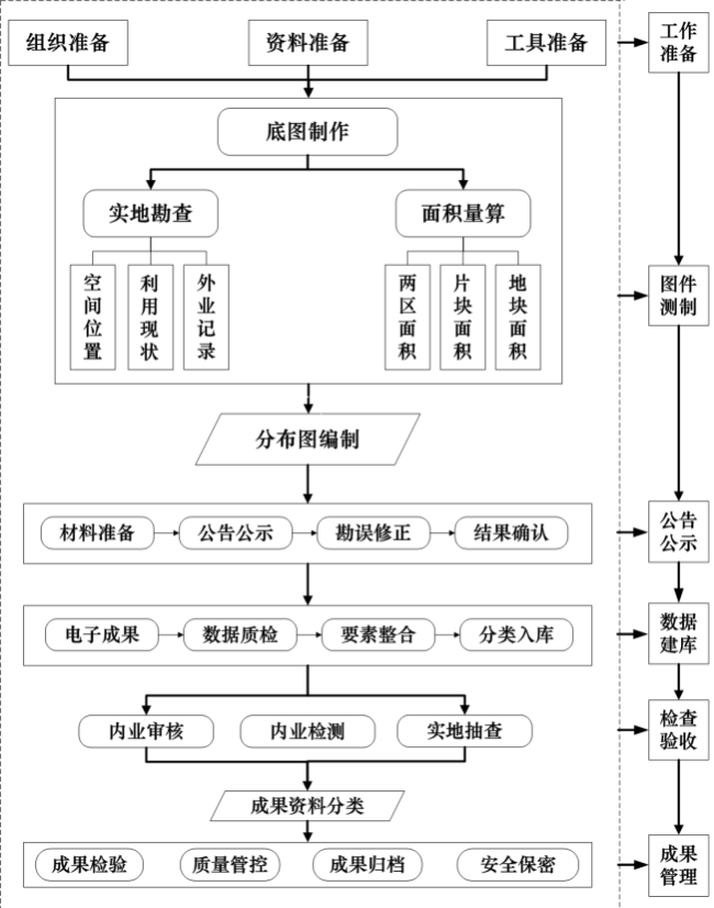
2.2 业务流程
根据前期研究,设计“两区”划定的业务流程如图1 所示。“两区”划定通过图件测制和数据建库等关键环节,实现对“两区”基础数据、专题数据、管理数据和统计数据的有效集成。
2.3 “两区”划定的空间结构设置
“两区”划定与以往永久基本农田划定以及农村土地承包经营权调查在工作定位和业务内容上存在较大差异。从业务对象来看,永久基本农田划定的定位在于依据土地利用总体规划确定不得占用的耕地,农村土地承包经营权调查的定位在于确定、确认农村承包地的所有权、使用权和经营权。与这两类业务相比,“两区”划定的目标定位更多元化,主要是确保粮食作物和重要农产品有效供给的生产区域,在农地的基础上,更关注的是粮食安全和农业生产。
因此,本研究考虑未来“两区”在农业生产管理和农业政策落实方面将起到的作用,确定了“两区”划定空间结构的设计思路:
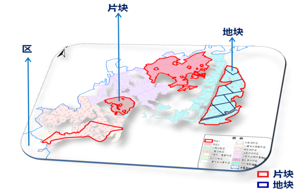
2)在村域范围内,应明确“两区”具体地块,不是所有耕地都能种植粮食作物和重要农产品作物,也不是所有地块都常年种植某种作物,还需考虑轮作换茬的情况,因此,“两区”地块应是在“两区”片块范围内,以实际宽度不小于1m的农村道路、沟渠、水系等线状地物或区域界线为边界所划定的具体的空间种植单元[18];
3)从“区域”层面的概念到“地块”层面的落实,过程中还需考虑规模化种植和经营管理的层面,在“两区”和“两区”地块这两个层级之间应有一个便于统筹指导乡域范围内农业生产和农事管理的“两区”片块层级,单个“两区”片块可跨越村组区域界线,但原则上不得跨越乡级区域界线[18]。
综上,结合农业生产管理的业务需求和数字化成图的拓扑关系需求,为“两区”划定设计了“区—片块—地块”三个层级的空间结构,其相对位置和空间分布形式如图2 所示。其中,区是概念层级,不设具体边界;单个粮食生产功能区(重要农产品生产保护区)内可包含若干片块,单个片块内可包含若干地块[18]。
2.4 关键技术
2.4.1 基于多源农地空间数据的“两区”划定图件测制
在“两区”划定的业务流程中,图件测制是实现“上图入库”的步骤之一,包括底图制作、实地勘查[23]和分布图编制三个技术环节,并在实地勘查前后,通过面积量算确保“两区”的图、数和实地一致。
“两区”划定的图件测制不是对现有农地空间数据矢量图层的简单复制和边界微调,也不是仅凭人工判读进行图层勾绘,而应充分考虑“两区”的行业功用,以“两区”划定的空间结构(“区—片块—地块”)为制图导向,融合现有多源农地空间数据在空间分布和语义属性上的关联性,在一定的空间尺度上制作“两区”空间分布图。其中,“两区”工作底图的制作是最为基础也是最为重要的环节,底图的质量依赖于现有农地空间数据的质量以及多源农地空间数据之间的协同分析和应用(图3 )。
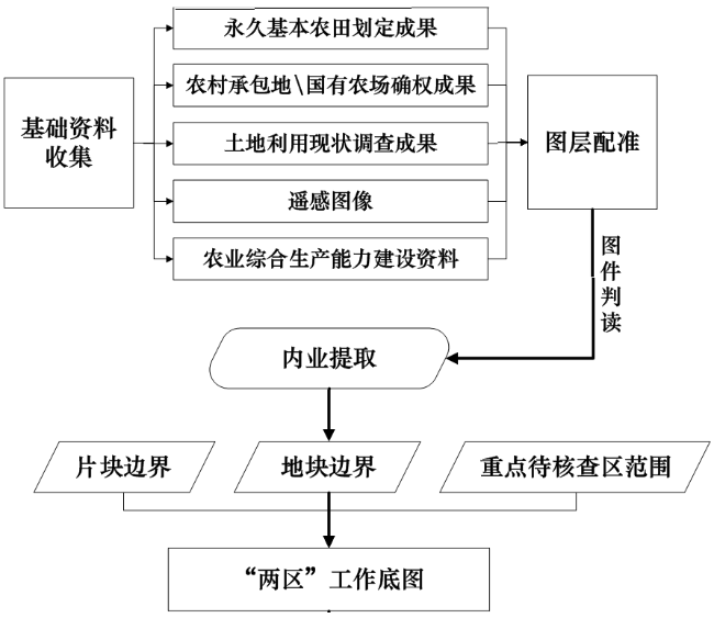
“两区”工作底图制作的总体思路是:首先,以永久基本农田的空间位置作为划“区”的基础,同时以耕地质量和坡度等级等专题信息作为划“区”的筛选条件,初步确定“两区”的基本范围;然后,以农村承包地块的空间位置作为“地块”边界的基础参照,并根据种植结构专题信息对农村承包地块进行归并,初步划出“两区”地块边界。再以农地流转情况等专题信息[24]和土地利用地类图斑作为“片块”的判别依据,并结合土地利用线状地物的空间位置初步划出“两区”片块边界。最后,考虑地类可能发生变化的农地以及未发包的集体耕地等情况,确定有待核查的重点区域范围。在此过程中,通过对多源农地空间数据中可用信息的关联使用,绘制“两区”地块、“两区”片块和实地重点核查区域的矢量图层,形成“两区”工作底图,作为实地勘查和属性记录的图件载体。在底图制作的过程中,制图尺度还需要通过对区域地形地貌和可用遥感图像比例尺的综合分析进行选择。具体步骤如下:
1)多源农地空间数据图层的匹配校正:按照统一的数学基础(CGCS2000坐标系[25],高斯—克吕格投影),对永久基本农田划定成果、土地利用现状调查结果、农村土地承包经营权确权登记成果、数字正射影像等基础资料图件进行图层间的匹配校正。
3)多源农地数据图层叠加分析:以数字正射影像为底层数据,将“两区”初始范围边界以及匹配校正后的其他基础数据图层一起叠加到数字正射影像图层上,根据多层基础数据的矢量边界和数字正射影像上耕地地块的几何特征,进行综合判读分析。
4)“两区”地块勾绘:在“两区”划定的初始范围边界内,以实际宽度不小于1m的线状地物和自然边界为界线,结合局地尺度的耕地质量、地类用途和种植结构,进行“两区”地块勾绘,并以耕地耕作边界作为“两区”地块的范围线。
6)在“两区”空间范围预分析的基础上,勾绘出“两区”片块、“两区”地块的初始边界,同时确定实地核查的重点区域边界,对“两区”片块和“两区”地块赋予预编码,制成“两区”电子工作底图。
2.4.2 基于多源农地空间数据的“两区”划定数据建库
“两区”划定用到了多源农地空间数据的本底数据,同时产生了多源异构的“两区”属性数据,数据来源多、数据类型复杂。从数据处理流程看,包括原始数据、过程数据、结果数据等。因此,除存储备份、查询检索等一般功能外,还需对数据进行规整、转换、检查、处理和入库,实现多源数据重组和标准化管理。通过数据重组,形成具有统一时空基础和标准格式的“两区”划定数据集,确保建库质量。
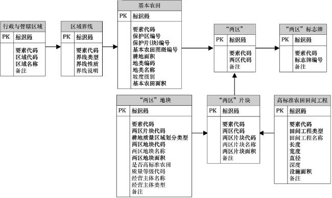
基于多源农地空间数据的“两区”划定数据库设计,主要是建立在需求分析和概念设计的基础上[28,29,30,31]。首先,分析确定“两区”划定数据建库的业务活动,包括3个方面:一是“两区”数据库内的电子成果内容应与表册、图件、文本等纸质成果资料一致,同时要与实际地块信息对应;二是“两区”数据库应能够实现对“两区”划定成果数据的查阅、增加、删减、修改、更新等功能;三是“两区”数据库要与永久基本农田、农村承包地等多源农地空间数据的本底数据库衔接。其次,通过设计“实体—关系”(Entity Relationship,E-R)模型,定义“两区”划定的地理空间实体,分析并抽象化地理空间实体之间的关系,将需求分析得到的“两区”划定数据建库业务活动抽象为空间信息结构,如图4 所示。
2.5 问题讨论
2.5.1 多源农地空间数据的偏差
“两区”划定图件测制过程中,采用的农地空间数据主要包括永久基本农田、土地利用现状、承包地、高标准农田等农地专题信息数据以及相应区域的对地观测数据,蕴含了政策与农地的关系,既能反映政策行为,又能反映地理要素,多源农地空间数据的结合使用也有助于提高划定工作效率。但是,对于上述多源农地空间数据的数据挖掘,不可避免要面临多源数据聚合引起的数据偏差问题[32,33],包括因数学基础不一致引起的多源异构农地数据空间错位,因制图比例尺不唯一引起的小范围制图精度不一致,因多源地类图斑的分类系统不一致引起的空间语义多样性等等。因此,从实现业务流程的角度出发,“两区”划定业务流程的首要关键问题是如何有效解决图件测制过程中所使用的多源农地空间数据偏差。
具体做法是,综合考虑信息源和用户需求等多个层次,分析永久基本农田划定成果数据、承包地确权成果数据以及高标准农田上图入库成果数据等多源农地空间数据的信息可用性,比如,坡度等级、耕地质量、地块图斑、地类用途、种植结构、集中连片程度等数据信息的实地一致性;在此基础上,构建可划入“两区”的农地综合评价指标体系,建立满足“两区”农地信息演化应用的可用性评估模型;并在相同的地理空间位置上进行多源异构农地空间数据的语义建模、相似性度量和语义归一化,探索多源农地信息的非线性偏移规律,研究数据流程中多源异构农地空间数据的动态聚合,实现“两区”划定业务逻辑与数据流的有效统一。
2.5.2 多源农地空间数据的局部缺失
如前所述,“两区”划定是一个系统性的工程,“两区”数字化成图建立在永久基本农田保护图斑和承包地地块等多源农地空间数据基础之上。每种来源的农地空间数据各自对应不同的功能。首先,以永久基本农田为基础,是按照永久基本农田保护区的矢量边界,确定可划入“两区”的农田范围;其次,承包地地块图层作为绘制“两区”地块图层的主要参考依据;最终根据以数字正射影像为主要数据源的对地观测数据进行判读分析。根据不同地区所收集的多源农地空间数据的完整性,“两区”数字化成图面临3种特殊情况(图5 ):一是只有基本农田资料的“两区”工作底图制作,二是只有承包地地块资料的“两区”工作底图制作,三是在农地空间数据缺失的区域“两区”工作底图制作。具体地,就是要解决3种特殊情况下“两区”片块和“两区”地块的划定问题。
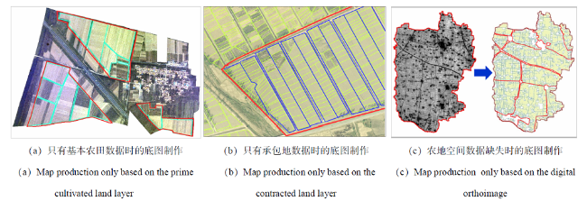
针对上述3种特殊情况,分别采取自上而下勾绘、自下而上勾绘和“人机交互”半自动化遥感图像处理方式,形成“两区”工作底图。
当只有基本农田资料时(图5 (a)),叠加分析基本农田和遥感影像,依据基本农田范围,绘制“两区”片块边界;再判读遥感影像,勾绘“两区”地块边界;根据“两区”划定空间架构,这是一种自上而下的制图模式。图5 (a)中,红色边框是通过修改基本农田保护图斑图层中的地类变化区域所生成的“两区”片块;青色边框是根据判读“两区”片块覆盖的遥感影像,以1m宽的线状地物为边界生成的“两区”地块。
当只有承包地地块资料时(图5 (b)),叠加分析承包地块和遥感影像,判读遥感影像,合并承包地块,绘制“两区”地块边界;再判读遥感影像,进一步勾绘“两区”片块边界;根据“两区”划定空间架构,这是一种自下而上的制图模式。图5 (b)中,蓝色边框是通过合并承包地地块,并以1m宽的线状地物为边界生成的“两区”地块;红色边框是通过进一步判读遥感影像,结合土地流转后的经营主体信息绘制的“两区”片块。
当农地空间数据缺失时(图5 (c)),既没有收集到基本农田资料,也没有收集到可用的承包地地块资料,需采用图像分割、边缘检测等遥感图像处理方法[34],绘制“两区”地块边界和“两区”片块边界。图5 (c)中,红色边框和蓝色边框分别是通过遥感图像处理得到的“两区”片块和“两区”地块,其中,“两区”片块边界主要利用图像分割算法[35]生成,分割参数的设置需考虑县道、省道、国道、大的河流水系等明显线状分界的常规宽度;再通过选择并建立基于高分辨率遥感影像的地块边缘矢量样本,训练影像数据,构建“两区”地块边缘提取模型,对每个“两区”片块内的遥感影像进行边缘检测[36],并对边缘检测栅格做矢量化处理,得到“两区”地块边界。
3 结论
“两区”划定是建立粮食生产功能区和重要农产品生产保护区的首要任务。本研究归纳了“两区”和多源农地空间数据的基本概念,在对比分析业务特色的基础上,总结了基于多源农地空间数据的“两区”划定关键技术,形成了“两区”划定技术环节中的关键科学问题,得出如下结论:
(1)“两区”划定是一项系统性工程,目标是确保国家粮食安全,保障重要农产品有效供给。因此,需要利用永久基本农田划定和农村土地承包经营权调查等土地管理工作所积累的多源农地空间数据作为基础数据来源,通过对多源空间位置数据和复杂结构属性数据的有效聚合,实现划定业务流程。
(2)“两区”划定与永久基本农田划定、农村土地承包经营权调查等同类业务相比,具有更明确的行业需求和更多元化的目标定位,业务流引入的语义差异,使数据流在空间尺度和时间等维度上产生了相应特色,因此,需要设置“两区”划定空间结构来定义“两区”划定的业务对象,约束“两区”划定的操作过程,并为今后实现“两区”政策管理功能提供支撑。
(3)在“两区”划定图件测制和数据建库等关键技术环节中,通过综合考虑数据源和用户需求,分析多源农地空间数据的信息可用性,降低多源农地空间数据的偏差及局部缺失对图件测制过程造成的影响,实现对“两区”基础数据、专题数据、管理数据和统计数据的有效集成,将为下一步建立“两区”农业智能化应用管理平台提供有效数据支撑。


