Smart Agriculture ›› 2025, Vol. 7 ›› Issue (6): 210-224.doi: 10.12133/j.smartag.SA202509027
• Special Issue--Remote Sensing + AI Empowering the Modernization of Agriculture and Rural Areas • Previous Articles Next Articles
LIU Miao1, ZHANG Jiayi1, LI Zhenhai1, CHEN Jing2( )
)
Received:2025-09-15
Online:2025-11-30
Foundation items:National Natural Science Foundation of China(42001208)
About author:LIU Miao, E-mail: liumiao0228@163.com
corresponding author:
CLC Number:
LIU Miao, ZHANG Jiayi, LI Zhenhai, CHEN Jing. Analysis of the Spatiotemporal Evolution and Driving Forces of Rural Settlements in Relation to Terrain Differences[J]. Smart Agriculture, 2025, 7(6): 210-224.
Add to citation manager EndNote|Ris|BibTeX
URL: https://www.smartag.net.cn/EN/10.12133/j.smartag.SA202509027
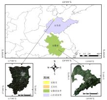
Fig. 1
Location map of Laoling city and Yi'an district
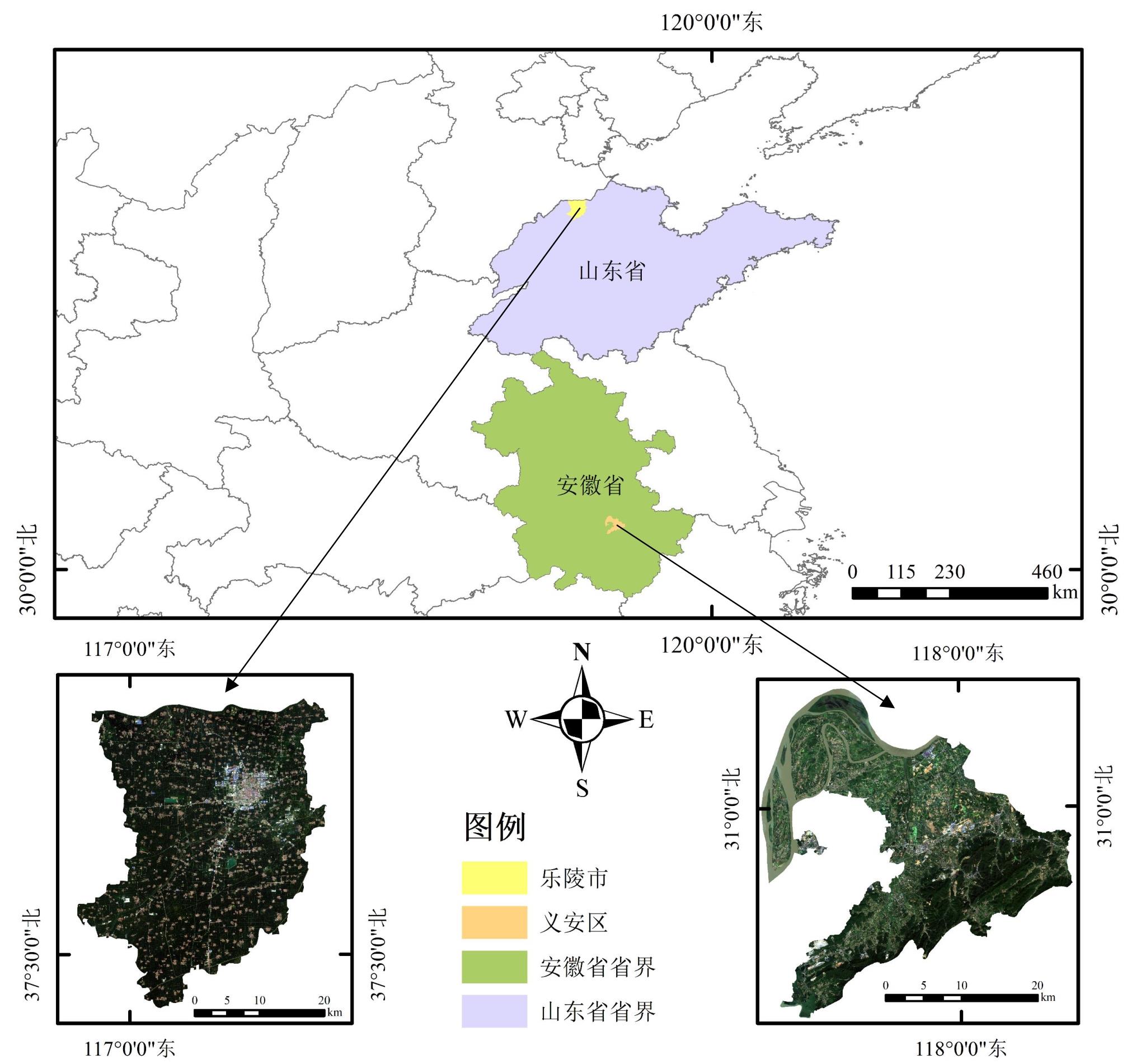
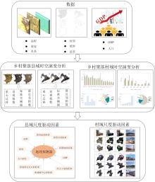
Fig. 2
Flowchart of the spatio-temporal evolution and driving factors of rural settlements

Table 1
Landscape indices of spatial evolution of rural settlements
| 景观指数 | 表达公式 |
|---|---|
| 最大斑块指数[ | (1) |
| 斑块密度[ | (2) |
| 景观形状指数[ | (3) |
| 聚合指数[ | (4) |
| 平均分形指数[ | (5) |
Table 2
Indicators of driving factors for rural settlements
| 类型 | 驱动因子 |
|---|---|
| 自然因素 | X 1:高程 |
| X 2:坡度 | |
| 社会经济因素 | X 3:人口密度 |
| X 4:GDP | |
| 区位因素 | X 5:距城镇中心的距离 |
| X 6:距主干道的距离 | |
| X 7:距地质灾害点的距离 | |
| X 8:距耕地的距离 | |
| X 9:距景点的距离 | |
| X 10:距河流的距离 |
Fig. 3
Spatial distribution map of rural settlements in Laoling city and Yi'an district from 2002 to 2022

Table 3
Landscape indices of Laoling city from 2002 to 2022
| 年份 | PD | LPI | LSI | AI | FRAC_MN |
|---|---|---|---|---|---|
| 2002 | 0.52 | 0.88 | 66.86 | 95.29 | 1.13 |
| 2012 | 0.53 | 1.68 | 72.26 | 95.16 | 1.14 |
| 2022 | 0.53 | 2.46 | 56.99 | 96.09 | 1.11 |
Table 4
Landscape indices of Yi'an district from 2002 to 2022
| 年份 | PD | LPI | LSI | AI | FRAC_MN |
|---|---|---|---|---|---|
| 2002 | 9.16 | 0.09 | 139.06 | 76.61 | 1.12 |
| 2012 | 6.69 | 0.26 | 104.32 | 83.59 | 1.13 |
| 2022 | 2.77 | 0.56 | 87.74 | 90.42 | 1.11 |
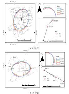
Fig. 4
Analysis of the centroid migration and standard deviation ellipse of rural settlements in Laoling city and Yi'an district in 2002, 2012, and 2022

Table 5
Measurement table of standard deviation ellipses for the spatial distribution of rural settlements in Laoling city in 2002, 2012, and 2022
| 年份 | 平均中心X坐标/m | 平均中心Y坐标/m | 长轴/m | 短轴/m | 旋转角度/(°) |
|---|---|---|---|---|---|
| 2002 | 512 427.4 | 4 169 319 | 11 040.44 | 17 049.10 | 18.82 |
| 2012 | 512 387.9 | 4 170 523 | 11 371.65 | 16 743.21 | 17.03 |
| 2022 | 512 914.1 | 4 171 151 | 11 210.49 | 15 629.11 | 15.29 |
Table 6
Measurement table of standard deviation ellipses for the spatial distribution of rural settlements in Yi'an district in 2002, 2012 and 2022
| 年份 | 平均中心X坐标/m | 平均中心Y坐标/m | 长轴/m | 短轴/m | 旋转角度/(°) |
|---|---|---|---|---|---|
| 2002 | 588 519 | 3 424 232 | 13 860.97 | 11 552.34 | 72.49 |
| 2012 | 588 084 | 3 425 245 | 13 702.85 | 11 154.71 | 74.49 |
| 2022 | 587 975 | 3 424 426 | 13 644.14 | 11 949.94 | 52.67 |
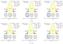
Fig. 5
Average nearest neighbor analysis of rural settlements from 2002 to 2022
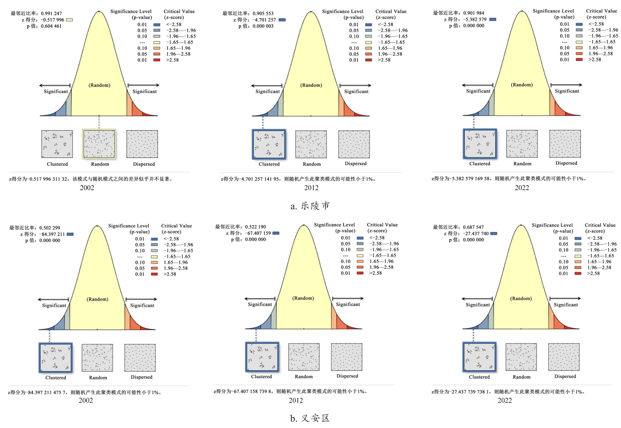
Fig. 6
Changes in rural settlement areas of villages in Laoling city from 2002 to 2022

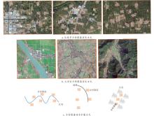
Fig. 7
Evolution patterns and illustrative examples of rural settlement changes in Laoling city and Yi'an district
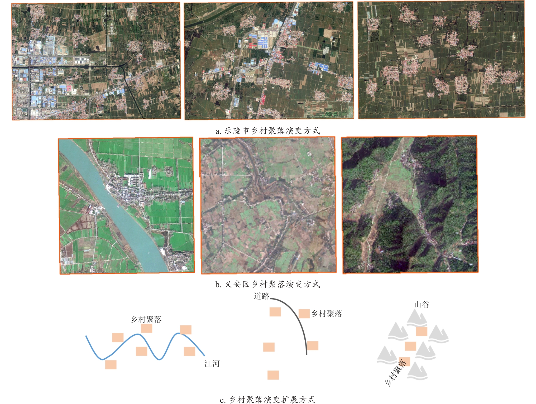
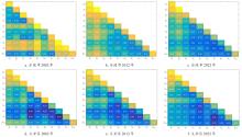
Fig. 8
Interaction detection maps of driving factors for Laoling city and Yi'an district in 2002, 2012, and 2022


Fig. 9
Village change map of Laoling city
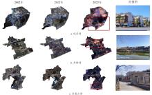
Fig. 10
Village change map of Yi'an district

| [1] |
郑小玉, 刘彦随. 新时期中国"乡村病"的科学内涵、形成机制及调控策略[J]. 人文地理, 2018, 33(2): 100-106.
|
|
|
|
| [2] |
刘守英, 王一鸽. 从乡土中国到城乡中国: 中国转型的乡村变迁视角[J]. 管理世界, 2018, 34(10): 128-146, 232.
|
|
|
|
| [3] |
李阳, 张晓彤, 宇林军, 等. 产业聚集型乡村聚落空间演变模拟模型研究: 以宁波市5个村为例[J]. 西部人居环境学刊, 2022, 37(4): 48-53.
|
|
|
|
| [4] |
张松梅. 十九大以来的我国乡村振兴战略研究综述[J]. 特区经济, 2021(7): 103-106.
|
|
|
|
| [5] |
刘彦随. 中国新时代城乡融合与乡村振兴[J]. 地理学报, 2018, 73(4): 637-650.
|
|
|
|
| [6] |
周政旭, 罗亚文. 黔中白水河谷地区山地布依民居研究[J]. 西部人居环境学刊, 2016, 31(5): 98-105.
|
|
|
|
| [7] |
李小建, 许家伟, 海贝贝. 县域聚落分布格局演变分析: 基于1929—2013年河南巩义的实证研究[J]. 地理学报, 2015, 70(12): 1870-1883.
|
|
|
|
| [8] |
黄亚平, 郑有旭. 江汉平原乡村聚落形态类型及空间体系特征[J]. 地理科学, 2021, 41(1): 121-128.
|
|
|
|
| [9] |
张静飞, 何艳芬. 1990—2020年长春市乡村聚落与耕地的空间关系分析[J]. 城市建筑, 2025, 22(3): 41-49.
|
|
|
|
| [10] |
楼雨晨, 黄璐, 李昂, 等. 太湖流域乡村聚落百年格局演变及其影响因素: 以浙江省湖州市为例[J]. 水土保持研究, 2025, 32(4): 320-331.
|
|
|
|
| [11] |
朱晓雯, 石云, 李建华, 等. 宁夏不同地理分区乡村聚落时空演变对比研究[J]. 地域研究与开发, 2023, 42(4): 155-161.
|
|
|
|
| [12] |
杨倩, 吴雷. 湖泊流域乡村聚落时空演变、影响因素及空间重构: 以巢湖流域为例[J]. 西华师范大学学报(自然科学版), 2024, 45(6): 639-648.
|
|
|
|
| [13] |
林广, 王妍, 王蕾, 等. 峰丛洼地石漠化区乡村聚落的形态学特征及空间演变规律[J]. 水土保持学报, 2025, 39(1): 348-358.
|
|
|
|
| [14] |
葛敬天, 张玥, 赵森, 等. 南太行山区聚落空间格局特征及其影响因子: 以河南新乡地区为例[J]. 风景园林, 2024, 31(12): 96-104.
|
|
|
|
| [15] |
杨定, 宋金平, 杨振山, 等. 藏族聚居区乡村聚落景观及其基因特征: 以隆子县为例[J]. 地理科学, 2024, 44(10): 1791-1800.
|
|
|
|
| [16] |
吴伟. 礼泉县乡村聚落空间演化机制及格局优化研究[D]. 西安: 长安大学, 2024.
|
|
|
|
| [17] |
李婷婷, 冯达, 张志坚. 1990—2020年湖南省乡村聚落时空演变特征研究[J]. 国土资源导刊, 2025, 22(1): 29-36.
|
|
|
|
| [18] |
张宝英. 豫东地区乡村聚落空间分布特征研究——以河南省商丘市为例[J]. 安徽农业科学, 2022, 50(3): 209-212.
|
|
|
|
| [19] |
周向丽, 王智超, 刘益珠, 等. 基于MGWR的乡村聚落空间演变的影响因素分析: 以海口市为例[J]. 热带地理, 2023, 43(8): 1599-1610.
|
|
|
|
| [20] |
王玮, 韦姿言, 张嘉龙, 等. 基于KANO模型分析的生态乡村景观设计需求聚类研究: 以长三角地区乡村聚落为例[J]. 现代城市研究, 2024, 39(8): 120-125.
|
|
|
|
| [21] |
|
| [22] |
王绍邦, 李志英, 龙晔. 滇中高原湖区乡村聚落空间演化及驱动因素[J]. 水土保持研究, 2025, 32(2): 387-395.
|
|
|
|
| [23] |
朱江昆, 陈占祥, 谭刚毅. 江汉平原乡村聚落格局时空演变及驱动机制研究(1990—2020)[J]. 城市环境设计, 2024, (5): 670-677.
|
|
|
|
| [24] |
忻益慧, 朱天龙, 牛豪毅. 冀西北地区体文旅资源空间分布及影响因素研究[J]. 河北建筑工程学院学报, 2024, 42(4): 156-161.
|
|
|
|
| [25] |
蒋雨欣, 戴文远, 陈娟. 闽东丘陵山区乡村聚落空间格局演变及其影响因素: 以福建省屏南县为例[J]. 水土保持研究, 2024, 31(3): 311-319.
|
|
|
|
| [26] |
乐陵市统计局. 乐陵市统计年鉴(2022)[M]. 乐陵:乐陵市统计局, 2022.
|
| [27] |
|
| [28] |
林高山. 基于高分二号卫星影像的乡村聚落信息提取及空间格局分析——以成都市金堂县又新镇为例[D]. 成都: 四川师范大学, 2019.
|
|
|
|
| [29] |
韦振锋, 梁珊珊, 黄群英. 山区城镇扩张对生态安全格局的影响及驱动特征研究: 以重庆市为例[J]. 国土资源科技管理, 2024, 41(5): 53-70.
|
|
|
|
| [30] |
|
| [31] |
周萌. 基于ArcGIS的六盘水市钟山区景观格局指数分析与优化[J]. 智能建筑与智慧城市, 2022(7): 53-55.
|
|
|
|
| [32] |
|
| [33] |
陈哲. 赣州市景观格局的演变与预测研究[J]. 江西科学, 2023, 41(5): 869-874.
|
|
|
|
| [34] |
徐远涛, 闵庆文, 袁正. 云南哈尼梯田景观格局指数筛选研究[J]. 资源与生态学报, 2013, 4(3): 212-219.
|
|
|
|
| [35] |
张佰林, 张紫涵, 周艳. 中国农村居民点重心迁移特征及其指示意义[J]. 北京大学学报(自然科学版), 2024, 60(5): 874-882.
|
|
|
|
| [36] |
高凡, 曹燕, 韩方红, 等. 基于3类空间变化的阿克苏河流域碳排放轨迹及生态环境效应[J]. 环境科学, 2024, 45(11): 6344-6353.
|
|
|
|
| [37] |
卢锋, 余建权, 陈振宇, 等. 基于POI数据的充电桩空间分布特征研究[J]. 现代工程科技, 2025(19): 1-4.
|
|
|
|
| [38] |
杜久升, 冯云超, 王羽河南省乡村旅游特色村空间分布格局及影响因素研究 [J]. 西北师范大学学报(自然科学版), 2023, 59(5): 127-134.
|
|
|
|
| [39] |
罗庆, 杨慧敏, 李小建, 等. 快速城镇化下欠发达平原农区的聚落规模变化[J]. 经济地理, 2018, 38(10): 170-179.
|
|
|
|
| [40] |
马晓蓉, 查小春. 秦巴山区乡村聚落空间格局演变及影响因子: 以陕西宁强县为例[J]. 山地学报, 2020, 38(5): 726-739.
|
|
|
|
| [41] |
储金龙, 姜昌正, 王霞. 基于县域地理差异比较的乡村聚落空间格局特征及其驱动因子影响研究[J]. 安徽建筑大学学报, 2024, 32(4): 8-15.
|
|
|
|
| [42] |
师皓容. 平川与丘陵山区乡村聚落景观特征比较研究[D]. 太原: 太原师范学院, 2024.
|
|
|
|
| [43] |
杨祎. 基于生态适宜性视角下的河湟地区乡村聚落更新策略研究[D]. 西安: 西安建筑科技大学, 2023.
|
|
|
|
| [44] |
万诗梦, 周星颖, 屠爽爽. 山地丘陵区乡村聚落景观格局演变特征及其影响因素: 以平果市为例[J]. 南宁师范大学学报(自然科学版), 2021(4): 130-140.
|
|
|
|
| [45] |
王存媛, 杨勐, 石殷忆. 乡村旅游视角下海岛渔村聚落空间更新策略研究: 以珠海大万山岛万山村为例[J]. 华中建筑, 2024, 42(1): 98-102.
|
|
|
|
| [46] |
罗庆, 王艺霏, 周晓庆, 等. 中国农民专业合作社空间格局及其影响因素[J]. 中国农业资源与区划, 2024, 45(5): 155-168.
|
|
|
| No related articles found! |
| Viewed | ||||||
|
Full text |
|
|||||
|
Abstract |
|
|||||


