Welcome to Smart Agriculture 中文
Topic--Development and Application of the Big Data Platform for Grain Production

Research Progress on Remote Sensing Monitoring and Intelligent Decision-Making Algorithms for Rice Production

  • ZHAO Bingting 1, 2, 3, 4 ,
  • HUA Chuanhai 1, 2, 3, 4 ,
  • YE Chenyang 1, 2, 3, 4 ,
  • XIONG Yuchun 1, 2, 3, 4 ,
  • QIAN Tao 1, 2, 3, 4 ,
  • CHENG Tao 1, 2, 3, 4, 5 ,
  • YAO Xia 1, 2, 3, 4, 5 ,
  • ZHENG Hengbiao 1, 2, 3, 4, 5 ,
  • ZHU Yan 1, 2, 3, 4, 5 ,
  • CAO Weixing 1, 2, 3, 4, 5 ,
  • JIANG Chongya , 1, 2, 3, 4
Expand
  • 1. National Engineering Technology Research Center for Information Agriculture, Nanjing Agricultural University, Nanjing 210095, China
  • 2. Engineering Research Center for Smart Agriculture, Ministry of Education, Nanjing 210095, China
  • 3. Key Laboratory of Crop System Analysis and Decision Making, Ministry of Agriculture and Rural Affairs, Nanjing 210095, China
  • 4. Key Laboratory of Information Agriculture, Jiangsu Province, Nanjing 210095, China
  • 5. Modern Crop Production Provincial and Ministry Collaborative Innovation Center, Nanjing 210095, China.
JIANG Chongya, E-mail:

ZHAO Bingting, E-mail:

Received date: 2025-01-01

  Online published: 2025-04-29

Supported by

National Key Research and Development Program of China(2023YFD2000103)

Copyright

copyright©2025 by the authors

Abstract

[Significance] Rice is a staple food crop worldwide, and ccurate monitoring of its growth is crucial for global food security. Remote sensing serves as a powerful tool in modern agriculture. By integrating remote sensing with intelligent decision-making algorithms, farmers can achieve more precise and sustainable rice cultivation. To provide actionable insights and guidance for researchers in this field, this review examines the latest advancements in remote sensing and smart algorithms for rice farming, while addressing current challenges and future trends. [Progress] Currently, remote sensing-based monitoring systems for rice production have been comprehensively implemented across the entire production cycle. For planting distribution identification, optical remote sensing and synthetic aperture radar (SAR) technologies complement each other to enhance accuracy through data fusion. Regarding growth period monitoring, a robust technical framework has been established, incorporating the empirical threshold method, shape model approach, and machine learning classification techniques. Dynamic evaluation of growth status is enabled by constructing correlation models between remote sensing features and biophysical parameters. Disaster monitoring systems provide rapid responses to various natural disasters. Yield and quality predictions integrate crop models, remote sensing data, and machine learning algorithms. Intelligent decision-making algorithms are deeply embedded in all stages of rice production. For instance, during planting planning, the integration of geographic information systems (GIS) and multi-criteria evaluation methods facilitates regional suitability assessments and farm-level quantitative designs. In topdressing management, nitrogen-based intelligent algorithms have significantly improved fertilization precision. Irrigation optimization achieves water conservation and emission reduction by synthesizing soil moisture and meteorological data. Finally, precise pesticide application prescriptions are generated using remote sensing and unmanned aerial vehicle (UAV) technologies. [Conclusions and Prospects] Despite significant progress, current research faces persistent challenges, including difficulties in multi-source data fusion, complexities in acquiring prior knowledge, insufficient model standardization, and barriers to large-scale technology implementation. Future efforts should prioritize the following six directions: (1) Technological innovation: Advance collaborative analysis of multi-source remote sensing data, design optimized data fusion algorithms, and construct an integrated air-space-ground monitoring network; (2) Intelligent algorithms: Explore cutting-edge techniques such as generative adversarial networks (GANs) and federated learning to enhance model adaptability across diverse environments; (3) Research scale: Establish a global rice growth monitoring system and develop multi-factor coupling models to assess climate change impacts; (4) Technology dissemination: Strengthen demonstration projects, reduce equipment costs, and cultivate interdisciplinary professionals; (5) Standards and protocols: Promote internationally unified standards for monitoring and decision - making frameworks; (6) System integration: Leverage technologies such as digital twins and blockchain to develop smart agriculture platforms for end-to-end intelligent management. Through multi-dimensional innovation, these advancements will significantly elevate the intelligence of rice production, offering robust support for global food security and sustainable agricultural development.

Cite this article

ZHAO Bingting , HUA Chuanhai , YE Chenyang , XIONG Yuchun , QIAN Tao , CHENG Tao , YAO Xia , ZHENG Hengbiao , ZHU Yan , CAO Weixing , JIANG Chongya . Research Progress on Remote Sensing Monitoring and Intelligent Decision-Making Algorithms for Rice Production[J]. Smart Agriculture, 2025 , 7(2) : 57 -72 . DOI: 10.12133/j.smartag.SA202501002

(登录www.smartag.net.cn免费获取电子版全文)

0 引 言

水稻是世界三大粮食作物之一1。提高水稻产量可预测性和了解水稻生长动态对于粮食安全和促进可持续农业实践至关重要2。传统的水稻种植和产量信息获取主要靠人力调查,对水稻田的破坏性大、工作效率低,且对样本数量和精度要求极高3。遥感技术能快速、客观、准确地获取地面信息,具有覆盖面积广4、重访周期短和成本相对较低5等优势,不需直接接触农田,减少了对水稻的干扰和损伤,能实现大范围水稻生长信息收集和分析,是进行水稻监测和产量估算的有效手段6
遥感数据通过光谱信息和波段组合7, 8反映作物生长状况,但遥感不能直接估算水稻产量,需结合大量实测数据9,如反演水稻生产相关参数,并探寻其与实测数据的内在联系3, 10,从而实现预测模拟水稻生产中可能遇到的问题、理解农田环境与水稻之间的相互作用11。目前,基于研究区域与时间间隔的差异,在利用遥感技术监测水稻生产时,会选用不同的遥感平台,如短时序小范围的研究多将星载、合成孔径雷达(Synthetic Aperture Radar, SAR)和无人机作为混合数据源融合使用实现水稻生长的精确模拟与估计12,不仅消除云对光学遥感传感器13和地形效应对雷达遥感传感器14的干扰,此外,对于部分水稻种植面积较小15, 16且地形复杂的区域,星载遥感数据源难以进行精准评估,而无人机遥感能够对此起到补充作用3。对于一些长时序大范围的研究,多使用单一遥感数据源17, 18,常用的遥感卫星有MODIS19、Landsat系列20、Sentinel-1/221, 22和GF系列18等。如今遥感已应用于水稻生产监测中的各个方面,如水稻种植分布23、生育期监测24、长势监测22、灾害监测25和产量估算26中,同样遥感也可应用于水稻种植规划、施肥决策27、灌溉决策28和喷药决策29等水稻智慧生产中。
现代信息技术(如互联网、大数据、云计算和人工智能)与农业的深度融合推动了智慧农业的发展30。发展智慧农业的目的是实现农业信息的全面感知、精准决策与高效管理31,而遥感能感知环境和气候变化,其丰富的数据源也容易与其他新技术结合,将是水稻智慧生产决策中的重要工具。利用遥感技术对水稻生产的水肥进行精确管理和实时监测,并应用于种植规划、施肥、灌溉和喷药等关键环节,通过智能分析,实现资源优化配置和环境“友好型”生产,为水稻高效种植提供科学支持。
为了更好地利用遥感指导水稻生产实践,本文全面综述了遥感技术在水稻种植分布、生育期监测和长势评估中的研究进展,重点分析光学与微波遥感在水稻监测中的优劣势,探讨多源遥感数据融合、人工智能等前沿技术的应用潜力,并提出未来研究的关键方向,以期为精准农业和水稻生产管理提供理论基础与技术支撑。

1 水稻生产遥感监测现状

目前水稻生产遥感监测研究主要聚焦于水稻种植分布、生育期监测、长势监测、灾害监测和产量品质估算等对于指导水稻生产实践和保证粮食安全都具有重要意义的方向(图1)。水稻种植分布是指通过遥感影像提取水稻物候特征23,对合理安排种植面积和品种布局,稳定粮食产量十分重要。水稻生育期监测指的是匹配特定植被指数或光谱信息与水稻特有的物候曲线从而及时判定水稻关键生育期转变24,准确把握各生长阶段,从而进行针对性的田间管理。水稻长势监测研究关注水稻生育相关参数,联合水稻生理参数和光谱特性22可以及时把控水稻对养分和水分的需求。水稻灾害监测是指通过光谱特性或结构指数的变化及时判断是否发生病虫害,对监测水稻生长也很重要25。水稻产量品质估算是利用遥感建立植被指数与水稻产量和直链淀粉含量的相关性32,大范围快速且精准获取水稻产量数据,实现早期预测与田间管理优化,为粮食政策制定、农业资源利用及可持续发展提供关键支撑。在水稻研究中,根据研究目的不同所采用的遥感数据源也不相同(表1),主要分为卫星遥感和无人机遥感两种。卫星在区域尺度依据光谱及植被指数识别水稻种植分布、生育期,监测长势、灾害并预估产量33;无人机凭借高分辨率影像,在复杂地形精准识别种植分布与生育期,精细监测长势、灾害,还能预估产量品质。不同遥感平台各有优势,为水稻全方位监测提供了多种手段。
图1 水稻生产遥感监测技术路线图

Fig. 1 Technical roadmap for remote sensing monitoring of rice production

表1 水稻监测中卫星和无人机监测要素表

Table 1 Table of monitoring elements of satellite and unmanned aerial vehicle in rice monitoring

遥感平台 监测要素
卫星遥感

水稻种植分布:基于不同光谱指数在不同生育期的变化识别水稻种植分布

生育期识别:利用植被指数时间序列的阈值及动态变化判断关键生育节点

长势:获取长时序、大规模的叶面积指数(Leaf Aera Index, LAI)、地上生物量等参数

灾害:旱涝灾害可利用与含水量相关植被指数变化监测,部分病虫害结合植被指数及环境因子判断

产量:结合作物模型,利用区域尺度的植被指数等信息进行预估

无人机遥感

水稻种植分布:在地形复杂区域,利用高分辨率影像精确识别

生育期识别:通过高分辨率图像观察作物表型特征确定关键生长期

灾害:精确判断水稻倒伏、旱涝灾害、识别病虫害

长势:实时、高精度监测LAI、叶绿素含量、光合作用效率等参数

产量品质:结合光谱、纹理数据和气象变量预估产量和籽粒品质

1.1 水稻种植识别

识别水稻种植分布是监测水稻生育期和长势的基础,在农业决策与生产管理中具有重要意义23。如何利用水稻独特的物候特征是水稻种植识别的关键33。在苗期,水层的信号在遥感观测到的信号中占主导地位,随着生育进程的推进,植株的信号逐渐占据主导地位。这种物候特征在光学遥感和SAR遥感的时间序列数据中具有不同的表现,成为不同水稻种植识别算法的基础。种植水稻的区域面积广泛,其种植区域的地形、气候条件差异巨大,有不同的种植制度,如单季稻、双季稻、三季稻和再生稻等,其遥感特征也呈现不同的变化周期。与单季稻相比,双季稻和三季稻的物候节奏更快32,再生稻遥感特征在原生稻株生长初期与单季稻或双季稻类似,随着再生稻株的发育,其遥感反射特征演变更为复杂,需关注其独特生长阶段带来的遥感特征差异34。另外不同的水稻种植方式(直播稻和移栽稻)也呈现出不同的遥感特征。直播稻播种期易确定但出苗受天气影响大,生长中期群体分散、叶面积指数(Leaf Aera Index, LAI)增长平缓,后期根系浅易倒伏,病虫害初期难识别25;而移栽稻返青期的特殊遥感特征是识别水稻分布的关键,生长中期群体整齐、LAI上升快,病虫害或倒伏在遥感影像中特征明显34

1.1.1 基于光学遥感影像的水稻种植识别

在光学遥感中,水体在短波红外范围内具有强烈的吸收峰,反射率接近于0,而浓密植被则有近红外反射率高、可见光反射率低的特点。水体指数和植被指数突出了上述特点,因此常被用于基于光学遥感影像的水稻种植识别34。水稻的移栽期到营养生长期可通过RGB影像的绿度逐渐加深、植被指数快速增大以及土壤水分逐渐降低判断,例如在移栽期和分蘖前期,陆地表面含水量指数(Land Surface Water Index, LSWI)通常高于归一化植被指数(Normalization Difference Vegetation Index, NDVI)和增强型植被指数(Enhanced Vegetation Index, EVI),而进入拔节期后则发生反转,即LSWI低于NDVI和EVI35。基于这些特征,研究者们提出了物候与像素相结合的水稻映射方法(Phenology and Pixel-Based Paddy Rice Mapping, PPPM)35,即基于水稻物候动态和像素级时间序列特征,结合遥感数据的光谱或后向散射变化,构建多维分类模型,以高精度识别和提取水稻种植区,并在众多研究中通过分析时间序列光谱特征(图2)对水稻种植分布进行提取36, 37。然而,在水稻分蘖后期和成熟期,植被指数趋于饱和,难以与其他高密度植被区分开来,因此通常需要设定阈值38或利用机器学习算法39进行判别。
图2 稻麦轮作植被指数变化序列图

Fig. 2 Sequence diagram of vegetation index changes in rice-wheat rotation

1.1.2 基于SAR的水稻种植识别

中国南方水稻种植区因受季风气候的影响,在水稻苗期往往难以获取无云的光学遥感影像数据40。SAR通过主动发射电磁波,记录地表散射回波特征实现目标观测,不受天气状况持续对地成像,成为水稻遥感监测的重要数据源。在水稻移栽期时,稻田主要表现为积水的散射特征,且田间积水吸收大量微波和侧视成像都会造成稻田镜面散射特征40,导致此时雷达可接收到的回波信号较弱;在水稻的营养生长期时,土壤、水稻植株、冠层和水面会发生多次散射,此时雷达可接收的信号变强,从回波信号由弱变强的趋势能识别水稻的种植分布41。因此,较多研究根据灌水前后VH波段(Vertical-Horizontal)极化后向散射特征值的特有变化(“V”型特征,图3)实现较高精度的水稻种植识别34
图3 水稻各物候期后向散射系数变化

Fig. 3 Changes in backscattering coefficient during different phenological stages of rice

1.1.3 光学和SAR数据协同

光学数据对水稻的光合特性敏感、空间分辨率更精细,SAR数据对水稻的介电特性和几何结构特性敏感,可全天候观测,水稻种植季节特殊,融合使用光学和SAR数据能有效提升识别水稻种植分布的精度42。光学和SAR数据可分为特征级融合和决策级协同43,其中特征级融合是指将光学遥感和SAR特征参数联合输入到分类器中;决策级协同是指使用光学或SAR数据互相在前期辅佐识别,不参与分类决策44。此外,使用非遥感数据(如地形45和水文数据43)补充遥感数据识别水稻种植分布,也可大幅提升水稻识别精度38

1.2 水稻生育期监测

通过遥感获取水稻种植生长信息,对预测水稻产量,及时优化灌溉和施肥等方面有重要作用24。水稻的生育周期可分为移栽期、分蘖期、拔节孕穗期和成熟期,而不同的生育周期往往能表现出不同的遥感特征,基于这些遥感特征可监测水稻生长。当前,主要的监测方法包括经验阈值法、形状模型法和基于数据驱动的机器学习分类方法。

1.2.1 经验阈值法

经验阈值法是通过给特定物候期的植被指数设定阈值46,依据是否超过该阈值来判断生育期演变24,如根据拟合的NDVI和EVI时间序列的极小值和极大值判断水稻的移栽期和抽穗期,用拐点来判断拔节期,用斜率的快速变化判断成熟期等24;动态阈值法通过植被指数与延迟平均值的差异确定水稻生育期45,如使用动态阈值法判断水稻的移栽期和成熟期47,该方法虽然不需要设立阈值,但是水稻生育期本身比较紧凑,滑动窗口的大小对于生育期的判断影响较大。

1.2.2 形状模型法

形状模型法是指将未知生育期的目标对象的植被指数时间序列曲线同已知生育期的参考对象的曲线进行对比和匹配,通过参考对象的生育期估算目标对象的生育期的方法48。形状模型法通过对年度植被指数序列的增长轨迹曲线进行拟合并取平均值生成49。该方法将多年平均曲线与单年的增长曲线匹配,有效消除传统方法中年际气候差异带来的异常值干扰。通过取平均值,降低特定年份局部异常值对曲线的影响。基于生成的形状模型及初步定义的物候参数,通过将形状模型与年度拟合的曲线匹配,准确确定年度物候日期50。但该方法对长期观测数据依赖较强,对数据不足或观测较短的地区,模型的适用性受限。

1.2.3 机器学习分类法

随着对机器学习方法的进一步使用和遥感图像分辨率的提高,基于数据驱动的机器学习方法也被运用到水稻生育期遥感监测51,该类方法,如支持向量机(Support Vector Machine, SVM)51、随机森林(Random Forest, RF)52和极限梯度提升53等,通过输入遥感数据和原始图像的特征提取,训练模型来监测水稻生育期。与遥感技术不同,计算机视觉技术通过高分辨率图像在小范围内观察作物的生长状态,并观察作物表型特征确定作物的生长期54。有研究通过从高分辨率数字相机获取的这些图像详细评估水稻的结构和质地,实现作物关键生长期监测55,如使用SVM和扩散-卷积神经网络来区分稻穗的图像斑块,检测到的“尖峰”数量为稻穗的抽穗数据55,并结合主成分分析和SVM识别水稻分蘖周期56。此外,深度学习能提升水稻生育期监测的精度57,例如,使用时间序列卫星数据,构建深度学习模型,分类识别水稻分蘖、抽穗和收获等不同生产阶段58, 59

1.3 水稻长势监测

水稻长势监测是水稻管理和产量预测的关键环节,对优化资源配置和提高农业生产效率具有重要意义60,而水稻生理参数反演是实现水稻长势监测的主要手段。利用卫星遥感数据可以获取长时序、大规模的水稻长势信息,而无人机能实时、高精度地监测水稻长势。在实际生产中主要关注水稻的LAI、地上生物量、叶绿素浓度、氮累计量、含水量、株高、基本苗以及穗数等生物物理参数22,通过经验模型、物理模型、半经验模型和数据同化等方法,建立遥感特征参数与水稻生物物理参数的映射关系61和预测模型62,能更好地监测模拟不同生长阶段和环境条件下的水稻生长信息和产量。

1.3.1 经验模型

利用经验模型建立遥感特征参数与水稻的生理参数之间的统计关系,是监测水稻长势的基础方法之一,主要包括回归分析、机器学习和深度学习方法22。统计回归方法利用线性模型、指数模型、对数模型或二次多项式模型确定水稻生理参数与遥感特征值之间的关系,是生产实践中最便捷的方法63,如利用光学遥感的多种植被指数建立与LAI的指数监测模型,预测模拟作物的光能利用效率63,或利用SAR的微波信号对水稻的几何特性敏感这一特点,利用最小二乘回归方法监测其株高和生物量的变化64。但水稻生长受多种因素(气候、土壤和肥料)影响,关系复杂且非线性62,机器学习算法(如主成分分析65、RF66)捕捉这些复杂的非线性关系,筛选大量与水稻生理参数有强相关的遥感特征值,如比较RF、逐元线性回归建立叶片含氮量与光谱反射率之间的关系,结果显示RF明显优于传统统计回归方法67。同样深度学习能够从多层神经网络中提取特征,直接处理遥感图像,如利用卷积神经网络(Convolutional Neural Network, CNN)识别水稻叶片氮含量68或基于数据驱动的时间序列模型收集环境数据,预测水稻的叶龄和茎长69

1.3.2 物理模型

物理模型是通过数学方程和数值模拟不同环境因子(如光照、水温和温度)与水稻生理参数之间的相互作用的模型40,主要分为光学辐射传输模型和微波辐射传输模型。光学辐射传输模型模拟光在水稻冠层的传播机制,并分析光与叶片、茎秆和土壤的相互作用65,如植被辐射传输模型(Prospect Scattering by Arbitrarily Inclined Leaves, PROSAIL)模型70及其变形形式71-73。通过变化模型参数,辐射传输模型能够模拟出不同的冠层反射率,将其与遥感观测的冠层反射率进行比较,模拟的反射率与观测的反射率最接近的参数即为遥感反演的解。常用的反演算法有查找表算法、优化算法和机器学习等74。其中,查找表算法是指利用预先生成输入输出参数映射表,并在实际应用中快速匹配或插值以反演目标参数的方法74。微波传输模型通过模拟不同空间结构和理化特性下微波的后向散射机制40,结合SAR影像和算法模拟真实的水稻散射过程,在模拟过程中会对水稻形状和散射机制简化75,将水稻归纳为有规则的几何体组合,在此基础上计算水稻的微波辐射传输方程,从而获得其冠层、下垫面之间的散射特性计算水稻生理参数(如株高、叶片含水量和稻穗数量等)76

1.3.3 半经验模型

半经验模型是一种结合了物理模型和经验模型特征的方法,通常以物理模型为框架,利用经验模型进行参数优化77。如水云模型(Water Cloud Model, WCM)根据水稻田的后向散射系数反演水稻的LAI和含水量等生理参数77。但水云模型未考虑冠层结构之间不同方向存在异质性,参数反演受到一定程度影响,因此在实际应用中需考虑到不同物候阶段水稻冠层的非均匀空间分布78,其结果也能优于原始的水云模型79。也有研究利用简单的半经验模型与植被指数和实测数据结合反演估计水稻生理参数80

1.3.4 数据同化算法

数据同化的基本原理是结合实测数据与同化算法,修改输入水稻生长模型的参数,使其模拟更接近实际81。水稻生长模型以作物生长原理为基础,通过机理性方法描述水稻生长过程与环境条件之间的关系,进而模拟水稻生育期、生理参数的动态变化和生产力的形成过程81。水稻生长模型的参数较多,模拟的不确定性较大,通过同化遥感数据,可以对水稻生长模型的参数进行校准和优化,提高模型模拟的准确性和可靠性。目前同化算法主要分为两种,一是参数优化同化法(如模拟退火算法82和粒子群算法83),即寻找模拟值与观测值差异最小的模型参数;二是顺序同化法(如卡尔曼滤波84),即实时更新模拟不同时刻的参数模拟植被生长参数。

1.3.5 无人机图像分析方法

无人机图像分析水稻长势相较于卫星遥感和微波遥感具有更高的空间分辨率和灵活性,能够提供更精细的区域性数据3。与卫星遥感相比,无人机能实时获取更高分辨率的多光谱或高光谱图像,便于详细监测水稻的健康状况和生长进度16。微波遥感在水稻长势分析中主要用于监测土壤湿度和水稻的物理结构变化,但分辨率较低,难以捕捉到细微的生长变化15。相反,无人机通过近红外和可见光波段的组合,能够更准确地评估水稻的叶绿素含量和光合作用效率,如无人机能实时、高精度监测水稻长势。利用无人机搭载各种相机(如多光谱、RGB和高光谱相机)拍摄实时水稻长势,通过提取纹理特征、覆盖率、植被指数的变化85和反演水稻长势参数迅速调整水稻管理措施86。总的来说,无人机遥感提供了更高的精度和灵活性,而卫星和微波遥感则适合大范围监测和环境因素分析。

1.4 水稻灾害监测

使用遥感手段监测水稻灾害能无损、快速、大范围收集环境因子和遥感影像来评判水稻是否受到灾害,以期尽快做出补救措施挽回产量损失87。水稻受到的灾害可分为形态结构损害(倒伏)、旱涝、冷热灾害和病虫害等88
水稻倒伏是由于强风、暴雨或过度湿润等条件引起水稻植株茎秆弯曲或倒伏的现象88,通过遥感手段能利用SAR数据对水稻的几何特性敏感的特点,借助后向散射系数的变化进行判别89,或者通过分析倒伏前后的光学遥感特征向量(如绿光和近红外波段的反射率值骤然下降)的差异来判断是否发生倒伏90
水稻旱涝灾害是在极端天气情况下,水稻种植区产生的干旱缺水或过量积水91。水稻干旱表现为叶片萎蔫、发黄,甚至死亡,而涝灾导致的积水过多会导致水稻根系缺氧、植株倒伏和病害加剧92。可利用无人机拍摄的RGB影像判断水稻冠层颜色和覆盖率的变化91,也可利用与水稻含水量相关的植被指数(如LSWI和NDVI)的变化判断是否受到干旱或多雨的影响93
水稻冷热灾害是由水稻生长期内的低温或高温而造成的生长发育障碍,水稻受到冷热灾害时并不会立即显现,会表现出生育进程缓慢和减产94。冷害主要表现在分蘖和抽穗扬花期的低温而抑制了水稻的光合作用,发育延缓等95。热害多见于高温条件下,主要影响抽穗开花期和灌浆期,导致蒸腾作用过强、水分供应不足,花粉不育和灌浆不足94。因此,研究水稻冷热灾害时还需判断其累积效应,如利用多光谱影像建立高温胁迫识别模型96,同时估算水稻热害的受灾面积和受灾等级97
水稻病虫灾害包括病害(如稻瘟病、白叶枯病)和虫害(如稻飞虱、螟虫)98。害虫因其特殊性需利用图像识别分类方法,如利用深度卷积神经网络(Deep Convolutional Neural Network, DCNN)识别植株上是否有害虫99,而水稻染病需针对特定疾病利用高精度的无人机高光谱影像和植被指数耦合(如病害导致叶片的光谱特征发生改变(红边移动、绿光反射增强、近红外反射降低))来判断100,或因该区域水稻产量减少,利用长时序植被指数(NDVI和NDRE)和环境因子判断是否染病101。在高温高湿环境下更易发生水稻病虫灾害98,如利用植株叶片的光谱特性,发现红边位置向短波方向移动,结合高湿数据验证病害传播模型,精准定位了稻瘟病高发区102,或通过遥感获取气温和湿度数据,结合稻飞虱的生命周期模型,模拟预测其种群扩展趋势,提前部署防治措施,有效降低了虫害造成的损失103

1.5 水稻产量品质估算

水稻产量与品质估算不仅是评估农业生产效益的关键指标,在农业资源合理配置与市场供需平衡中也具有重要意义26。水稻产量预估主要依赖于作物模型26、非线性机器学习104和深度学习105方法,水稻籽粒品质的预估方法主要包括基于感官评估、物理和化学分析的传统方法、遥感技术,以及现代实验室化学分析方法等106

1.5.1 水稻产量预估

卫星遥感图像已被广泛应用于监测区域和全球尺度的作物产量预测107。卫星遥感成本相对较高,易受天气影响且对一些小尺度的区域无法描述作物产量变化的细节108,相较而言,无人机技术更灵活且更实惠,能精确捕获水稻孕穗期开始节点109和水稻生产力变化趋势110。虽然遥感数据可根据图像和特征值推断水稻产量,但缺乏内在机理理解,需和作物模型结合111。作物模型是基于农学理论和物理规律,模拟环境条件和管理措施的变化对水稻生长过程中产量和生理参数的影响102。遥感能校准作物模型的参数,减少参数误差,并有效反映因区域异质性引起的产量差异,从而提高水稻产量估算的精度,为水稻精细化管理提供支持26。常用的作物模型包括水分核算与风险管理模型(Water Accounting and Risk Management Model, WARM)26、水稻作物环境资源综合模型(Crop Environment Resource Synthesis for Rice, CERES-Rice)112、农业生产系统模拟器(Agricultural Production Systems Simulator, APSIM)113等。模型在不同地区和不同年份的水稻产量预估中的泛化能力有所不同,尤其在环境变化较大时,可能导致较高的误差114。为实现更精确、高效和及时的作物产量预测111,结合机器学习、深度神经网络算法和遥感数据,有助于克服传统作物模型的局限性104
利用机器学习构建数据驱动的水稻产量预测模型,通过处理遥感数据、气象数据、土壤和农田管理数据,能够实现高效、精准的水稻产量估算。在当前的作物产量估算研究中,学者们将线性和非线性机器学习模型104(如支持向量回归115、RF111、神经网络回归116, 117和卷积神经网络回归118)引入作物产量估算中,如利用卷积神经网络架构119,可从低空RGB图像和多光谱图像中学习与水稻产量相关的重要特征,并预测其研究区域的水稻产量。在大区域尺度上,已提出并应用数据同化结合作物模型进行产量估算的方法,这种方法的挑战是需要在区域范围内提供大量高质量的实测数据120。为解决这一问题,迁移学习逐渐成为产量预估中的一种潜在解决方案,如知识引导机器学习105,在降低数据需求的同时提高了预测的准确性为水稻产量预估提供了新的思路,并有望在实际应用中带来更高的效益;或者建立尺度迁移框架121,该框架在缺乏地面真值数据的情况下,能够有效进行田块尺度的作物产量预估,精度相对于传统方法显著提高。这些跨区域、跨尺度的预估实验提供了宝贵的经验,尤其是在气候变化日益复杂的背景下,采用综合性的方法能够有效提升预测模型的鲁棒性。

1.5.2 水稻籽粒品质预估

水稻籽粒品质的预估方法主要包括基于感官评估、物理和化学分析的传统方法、遥感技术,以及现代实验室化学分析方法等122。随着技术的发展,基于遥感122和机器学习123的非接触式预测方法在提高水稻籽粒品质预估的精度和效率方面发挥着越来越重要的作用。如利用无人机影像结合光谱、纹理数据和气象变量和模型分析,可提高淀粉和蛋白质含量的预估精度106。在众多决定大米品质的成分中,直链淀粉和蛋白质是影响大米口感和营养价值的关键因素106,基于无人机高光谱影像,分析在不同生长阶段光谱和纹理变量与直链淀粉含量的相关性,并建立不同变量组合的线性回归模型122,不仅简化了数据采集过程,还提高了水稻品质监测的精度122。基于多期关键生育阶段的无人机影像和卫星影像,采用层次线性模型(Hierarchical Linear Model, HLM)与典型植被指数和气象数据耦合的方法预估水稻品质,其预估结果在年际和区域尺度上对稻粒的蛋白质含量、淀粉含量以及水稻产量都表现出较好的预测结果123

2 水稻生产智慧决策算法

传统的水稻生产往往依赖经验,难以应对复杂多变的环境和众多相互关联的因素,而智能决策算法能够有效整合多源数据,通过建立数学模型和优化算法,定量分析不同栽培管理方案的可行性与综合效益,为水稻种植决策提供科学依据(图4)。遥感监测为水稻生产智慧决策算法提供有力支撑。识别水稻种植分布、产量估算和土壤属性估算能够有效辅助水稻种植规划,水稻生育期监测、长势监测和灾害监测则对水稻追肥决策、灌溉决策和喷药决策意义重大。
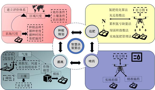
图4 水稻生产智慧决策算法技术路线图

Fig. 4 Roadmap for intelligent decision making algorithm technology in rice production

2.1 水稻种植规划

水稻种植规划旨在充分利用当地的自然资源和社会经济资源对生产环节进行系统安排与设计,实现水稻的高效、优质、绿色生产,同时降低生产成本、提高抗风险能力,保障可持续发展。水稻种植规划可分为区域尺度规划和农场尺度规划。
区域尺度的水稻种植规划主要聚焦于宏观层面的水稻种植适宜性评价与空间布局,其核心目的在于为农业主管部门提供科学、全面且具有前瞻性的决策依据124。已有算法运用地理信息系统(Geographic Information System, GIS)与多准则评价相结合的方法,利用层次分析等确定评价指标权重,进行加权叠加分析和多要素叠置综合评价,生成适宜性地图125。其中,评价指标体系通常涵盖地形条件(如高程、坡度、坡向)、土壤条件(如质地、厚度、酸碱度、有机质含量)、气象条件(如积温、平均气温、降水量)和农田基础设施条件(如灌溉保证率、排水条件)等126。通过卫星遥感技术得到的水稻种植分布及其他作物类型的种植分布在水稻种植适宜性评价中发挥了重要作用。例如,有研究借助最大熵模型对遥感监测所得的种植分布进行分析,来识别影响水稻种植的主导因子及贡献度,从而降低适宜性评价中指标选取与权重设置的主观性127
农场尺度的水稻种植规划是指在产前对水稻的产量目标、种植品种、播种时间、移栽密度、基肥施用等进行定量设计,主要服务于农业经营主体。产量目标设定算法通常综合考虑农场的土地资源状况、历史种植产量、市场需求预期,以及所具备的农业生产技术水平等因素。种植品种选择算法主要考虑农场的气候条件与土壤特性,根据水稻的生育期、生长特点和抗性对不同品种打分选择。播种时间确定算法主要依据当地气象部门提供的详细气象预报信息,结合所选水稻品种的生育期特性进行计算128。播种密度确定算法则需综合考虑水稻品种的株型特征、分蘖能力、土壤肥力状况,以及预期的产量目标等因素。基肥施用算法是依据土壤中氮、磷、钾等主要养分的丰缺状况,同时结合水稻品种在不同生长阶段的养分需求规律,制定科学合理的施肥方案。相比于产中的水稻调控决策,遥感在产前种植规划中发挥的作用较为有限。通过遥感估产能够捕捉到不同田块乃至田块内部的产量空间差异,从而可以在农场尺度设置空间变化的产量目标,进而影响种植品种、移栽密度、基肥施用等算法的结果。目前已有遥感算法能够区分出粳稻和籼稻,以及识别出再生稻,未来可能发展出水稻品种的空间制图来服务于种植品种选择算法。
基于短波红外、热红外和SAR的水稻移栽时间监测正在快速发展之中,随着多源遥感时间分辨率的提高,有望用于水稻播种时间的评估与优化。基于无人机遥感的数苗算法已相对成熟,为水稻移栽密度算法的改进奠定了基础122。最后,高光谱遥感甚至多光谱遥感已被用于土壤有机质制图,更高精度的土壤遥感监测算法将为基肥使用算法的应用提供有力支撑。

2.2 水稻追肥决策

传统施肥依赖固定方案,难以精准反映土壤和作物实际需求,易导致肥料浪费和环境污染129。精准施肥技术则因地制宜,根据营养亏缺状态优化施肥130,提高肥料利用效率。氮(N)素作为水稻生长中最为重要的营养元素之一,直接影响水稻的生长发育131、产量132和籽粒品质130,因此已有研究多将监测水稻氮含量作为水稻精确施肥技术的核心。
水稻追肥决策算法可分为实地氮肥管理法133(Site-Specific Nitrogen Management, SSNM)、氮肥优化算法134(N Fertilizer Optimization Algorithm, NFOA)、累积氮亏缺量法135(Accumulated Nitrogen Deficit, AND)、氮营养指数法136(Nitrogen Nutrient Index, NNI)、充足指数法137(Sufficiency Index, SI)和绿面积指数法138(Green Area Index, GAI)。SSNM法首先要设定一个可实现产量目标,接着估算在不施加氮肥情况下的产量,然后评估氮响应,即目标产量与无氮肥产量之间的差值,最后根据氮响应和氮利用效率来估算追氮量,并根据用土壤与植物分析仪(Soil and Plant Analyzer Development, SPAD)或叶色卡的测量得到的叶片氮状况进行调整。NFOA法通过计算目标产量下的籽粒氮吸收量、追肥时的植株氮积累量和氮利用效率来估算追氮量,其中目标产量通过季中的植被指数进行估算134。AND法中追氮量的计算是用氮亏缺量除以氮肥回收利用率。氮亏缺量有直接和间接两种计算方法。直接法是指通过机器学习方法从遥感观测数据中直接计算,间接法是用临界植株氮积累量减去遥感估算的实际植株氮积累量,而临界植株氮积累量需使用临界氮浓度稀释曲线和遥感估算的地上生物量进行计算132。NNI法的追氮量等于标准施氮量加上施氮量调控值,施氮量调控值由NNI法确定。NNI法也有直接和间接两种计算方式。直接法是指通过机器学习从遥感观测数据中直接计算,间接法是用遥感估算的实际植株氮积累量除以临界植株氮积累量139。SI法基于氮充足、高产田块的施氮量和待追肥田块的已施氮量、土壤供氮量,利用遥感的实时氮亏缺量来确定水稻的追氮量137。GAI法的追氮量利用理想状况下的GAI减去遥感估算的实际GAI乘以每增长1个单位GAI的需氮量,计算达到理想状态GAI所需的施氮量138。上述算法中,较为常用的水稻追肥决策算法是AND法和NNI法,二者均采用了临界氮浓度稀释曲线的概念140。临界氮浓度稀释曲线是作物达到最大生物量所需最小氮浓度的曲线,如公式(1)所示。
P N A c = a A G B - b
式中:PNA c为临界植株氮积累量,kg N/hm2AGB为地上生物量,t/hm2a表示AGB达到1 t/hm2时的PNA c,kg N/hm2b值为描述氮浓度随生物量增加的稀释速率(通常为负值,反映氮浓度下降趋势)。一旦通过氮肥试验建立了临界氮浓度稀释曲线,则根据遥感估算的实际植株氮积累量PNA aAGB可以快速诊断出水稻的氮营养状态:如果PNA aAGB所绘制的散点位于临界氮浓度曲线的下方,这说明作物处于氮素缺乏的状态141。使用该方法的主要挑战是ab随环境和品种而变化,较难获得具有普适性的估计值。

2.3 水稻灌溉决策

在水稻常规灌溉决策下,水稻生产消耗了约40%的全球灌溉用水142,并占全球人为排放甲烷的10%28,中国水资源严重短缺,因此,为了资源可持续利用和延缓全球变暖趋势,提出可持续的水稻灌溉决策是十分必要的。常用的灌溉措施有干湿交替灌溉、淹灌、雨养、控制灌溉和湿润灌溉143。如干湿交替灌溉不仅可以节省高达22%的灌溉用水还有助于减少甲烷排放144
在实际操作中,判断水稻是否需要灌溉主要依据是土壤水分状况、气象数据和作物模型等。基于土壤湿度阈值的灌溉方案指根据土壤的水分储量,估算土壤的水分平衡或根据土壤湿度传感器测量的土壤水分含量设定阈值判断是否需要灌溉145。如根据土壤水分传感器显示的值判断干湿交替的“干”的程度是否影响到水稻生长,判断是否需要灌溉146。基于气象数据的灌溉方案147是指利用蒸散发(Evapotranspiration, ET)、水分利用效率(Water Use Efficiency, WUE)和总初级生产力(Gross Primary Production, GPP)判断水稻利用和蒸发损失的水分,并估计灌溉中需要增加的水分,如判断灌溉是否符合植物生长的周期性变化以及判断生长季水稻冠层的潜在水分利用效率148。在灌溉过程中,将植物需水量与蒸散发量等与气候相关的指标连接,同样也能利用植物需水量耦合作物模型来模拟灌溉农业产量,如水资源评估与规划系统(Water Evaluation and Planning System, WEAP)和农业技术转移决策支持系统(Decision Support System for Agrotechnology Transfer, DSSAT)149将区域供水和管理与田间用水需求和作物生长联系,在浇水充足的条件下重现DSSAT的结果,并合理模拟观察到的平均产量。
气候变化对长期水资源管理和农业规划未来用水需求的影响也十分重要,密切监测和定期评估年/季降水量变化趋势、降水强度与极端降水频率和平均气温变化趋势等气候指标,可以了解降雨量和对分布的未来变化方向150,为规划未来的种植系统和优化水资源管理提供科学指南。如结合IPCC(Intergovernmental Panel on Climate Change)报告,可估计未来气候变暖对水稻灌溉量、有效降雨量和参考蒸散量的影响151

2.4 水稻喷药决策

水稻喷药决策是实现现代农业管理和智慧农业的关键环节,传统水稻喷药方式缺乏监测和科学指导,存在喷药不均、效果差等问题152。遥感、无人机精准喷药和智能决策为优化喷药提供了手段,可高效控制病虫害、减少农药使用、改善环境并提高水稻品质和粮食安全29。无人机精准喷药技术通过整合水稻长势监测和病虫害分布分析,实现了智能化施药决策。该系统首先利用无人机遥感获取水稻关键生长参数(如LAI、植被绿度等)和病害信息(包括稻瘟病、白叶枯病等典型病害的空间分布特征),随后通过决策模型将这些多源农田数据融合处理,生成数字化施药处方图153-155。如基于GIS分析病虫害的类别、危害程度信息等,得到病虫害处方图和优化喷药处方图,并应用于精准喷药决策系统156。同样,未区分种植区和空白区对降低施药经济成本也十分重要,如使用k-means提取水稻遥感影像特征参数,SVM训练模型,以区分水稻种植区和空白区,并生成无人机喷药决策,实现自动识别种植空白区域和在水稻区域的精准喷药100

3 挑战与展望

3.1 困难与挑战

虽然结合遥感数据与决策算法已成功应用于水稻生产的全生育期监测,但要精确管理水稻生产的各个方面仍需解决多项难题。
1)“空-天”遥感数据融合难。水稻种植条件特殊、种植季节湿热多雨,单一遥感数据源受地形或天气影响较大,需多数据源互补16。然而,各遥感数据时间和空间分辨率不一致、光学和雷达遥感获取图像的机理不同,且南方丘陵地带作为中国水稻主产区之一,种植面积迷你、地形复杂,卫星遥感数据源的空间分辨率较高,无法做到单一田块的精确管理16。通过特征、降尺度或差值等方式可融合卫星和无人机遥感数据,但无人机数据量庞大,处理和存储成本较高3。多源遥感数据可以提高研究精度,但需建立高效且具有针对性的统一数据标准。
2)种植制度不一,先验知识获取难38。水稻种植制度可分为田间管理措施和种植品种两个方面。对同一地区而言,不同的育苗、移栽、栽培条件(行距和株距)、灌溉技术、施肥量等田间管理措施会影响不同地块的水稻生长50。水稻品种会影响营养器官和生殖器官的大小、含水量、生长周期等,呈现出不同发育速度44。对不同地区而言,其地形、水温、气候和社会发展等都会影响水稻生长,如不同地区有单、双、三季稻和再生稻等水稻熟制,也有稻麦轮作等同一田块轮流种植不同种类作物的手段或在田边种植不同作物的间作方式都会影响到遥感光谱曲线。监测区域水稻种植,先验知识获取极其繁杂,水稻种植制度多样也会使得水稻种植分布识别难上加难。挑选样本不够具有代表性,都会影响水稻监测的精度。
3)地区差异大,模型参数难统一。现有水稻监测算法和模型的地区适应性过强,通用性和标准化程度不足。如不同生态区和水稻品种模型参数需重新调整,难以直接推广应用,限制了研究成果在更大范围的应用价值,增加了模型开发和应用成本。
4)智慧决策在实际农业生产中落地面临诸多问题。一方面,农民对新技术的接受和掌握程度有限,需要大量培训和技术支持;另一方面,农业生产环境复杂多变,算法在不同田块和气候条件下的稳定性和可靠性有待提高,且相关设备成本较高,在一些地区难以大规模推广,导致技术应用与实际生产需求之间存在较大差距。

3.2 前景与展望

随着遥感技术的快速发展和农业现代化水平的不断提升,未来水稻生产监测和预测研究可以从以下几个方面进行进一步探索。
1)多源数据融合与协同监测应用。重点构建“空-天-地”一体化的智能监测网络。通过突破多源数据融合的关键技术,如光学与雷达数据的特征级融合、时空尺度转换算法等,建立多分辨率(米级-亚米级)、多维度(光谱-纹理-时序)的协同观测体系。特别要研发自适应融合算法,解决多云多雨条件下的数据缺失问题,实现全天候、全生育期的水稻生长动态监测。同时,将探索传感器新型监测技术,进一步提升数据获取能力。
2)深入应用深度学习与人工智能技术。深度学习技术在水稻分类、长势监测及生育期识别中的应用潜力巨大。未来可以通过强化学习、迁移学习等方法,优化深度学习模型的训练策略,并开发更高效的算法以适应大规模遥感数据处理需求,重点突破小样本学习、自监督学习等前沿算法。针对水稻监测中的样本稀缺问题,开发基于迁移学习和元学习的自适应模型;利用强化学习优化模型训练策略,提升跨区域应用的泛化能力。同时,将构建水稻生长知识图谱,整合农学知识与遥感特征,发展可解释人工智能技术,提高模型决策的透明度。研发边缘智能计算设备,实现田间实时监测与预警。从而提升水稻监测的自动化和智能化水平。
3)深化长时序与大尺度研究。针对大范围区域的水稻生长监测和产量估算,长时序的遥感数据分析不可或缺。未来研究可进一步探索基于长时间序列数据的多物候期水稻监测模型,构建“气候-作物-管理”耦合模型,定量评估极端气候事件对水稻生产的影响。重点突破跨传感器、跨时相的时序数据同化技术,建立全球统一的监测基准,为粮食安全预警提供科学依据。
4)推广精准农业技术并落地。遥感监测为精准农业提供了重要的数据支撑,未来研究应注重遥感信息在农业生产中的实际应用,如优化灌溉策略、精准施肥与病害防控等。同时,通过农业物联网的发展,构建基于遥感数据的农田管理智能决策平台,推动水稻生产向精细化、低碳化方向发展。
5)标准化研究方法,增强普适性。针对水稻监测算法和模型通用性和标准化程度不足,未来需针对不同生态区和水稻品种开展研究,建立普适性强的模型与算法,并制定相关的遥感监测标准和规范,提升成果的推广价值和可实践性。
6)面向智慧农业的深度融合。智慧农业的核心在于通过现代信息技术实现农业生产的精准化与高效化。打造水稻数字孪生系统,实现从种植到收获的全流程数字化管理。通过4G/5G、数字孪生等新技术的融合应用,构建“感知-决策-执行-评估”的闭环管理系统。重点突破农业大数据治理、知识图谱构建等关键技术,形成可复制推广的智慧农业解决方案,全面提升水稻生产的智能化水平。
总之,水稻生产的遥感监测在技术革新、数据共享与方法优化的推动下,将在精准农业、粮食安全和全球农业可持续发展中发挥重要作用。未来的研究和实践需要多学科协作,技术创新与政策支持并重,以推动遥感技术更广泛、更深入地服务于农业生产与生态环境保护。

4 结 论

遥感技术在水稻生产中发挥着重要作用。在种植分布监测方面,通过时序特征提取和阈值提取等方法,结合分类算法及深度学习技术,可实现对水稻种植分布的精准识别,但面临数据融合和先验知识获取等难题。生育期监测可采用经验模型和机器学习方法,前者依赖先验知识且易受环境影响,后者精度受训练数据制约,深度学习虽可提升精度但需大量数据。长势监测通过估算LAI、氮累计量和地上生物量等生物物理参数,结合卫星和无人机遥感,为水稻生长信息监测提供了有效途径。灾害监测中,遥感可快速获取冷热、旱涝、倒伏和病虫等灾害信息,为农业管理提供重要手段。总之,遥感技术为水稻生产提供了全面、准确的监测手段,但仍需在数据融合和模型优化等方面不断探索。
水稻智慧决策算法涵盖种植规划、施肥决策、灌溉决策和喷药决策等方面。种植规划通过综合考虑多因素实现科学规划,提高产量和可持续性发展。施肥决策中,精准施肥技术以监测水稻氮含量为核心,多种方法结合可提供更精准的施肥建议,降低环境负面影响。灌溉决策通过改进灌溉方法、耦合相关指标和作物模型,实现节水减排并合理模拟产量。喷药决策利用现代信息技术生成处方图结合决策模型实现精准喷药,遥感平台为喷药决策提供科学依据。未来应进一步推动智慧决策算法与现代信息技术深度融合,提升水稻生产的精细化管理水平。

利益冲突声明

本研究不存在研究者以及与公开研究成果有关的利益冲突。

1
DONG J W, XIAO X M, MENARGUEZ M A, et al. Mapping paddy rice planting area in northeastern Asia with Landsat 8 images, phenology-based algorithm and Google Earth Engine[J]. Remote sensing of environment, 2016, 185: 142-154.

2
JEONG S, KO J, BAN J O, et al. Deep learning-enhanced remote sensing-integrated crop modeling for rice yield prediction[J]. Ecological informatics, 2024, 84: ID 102886.

3
ZHOU X, ZHENG H B, XU X Q, et al. Predicting grain yield in rice using multi-temporal vegetation indices from UAV-based multispectral and digital imagery[J]. ISPRS journal of photogrammetry and remote sensing, 2017, 130: 246-255.

4
YU W G, YANG G X, LI D, et al. Improved prediction of rice yield at field and county levels by synergistic use of SAR, optical and meteorological data[J]. Agricultural and forest meteorology, 2023, 342: ID 109729.

5
THORP K R, DRAJAT D. Deep machine learning with Sentinel satellite data to map paddy rice production stages across West Java, Indonesia[J]. Remote sensing of environment, 2021, 265: ID 112679.

6
ZHANG Y, YAN W J, YANG B, et al. Estimation of rice yield from a C-band radar remote sensing image by integrating a physical scattering model and an optimization algorithm[J]. Precision agriculture, 2020, 21(2): 245-263.

7
HE J Y, ZHANG N, SU X, et al. Estimating leaf area index with a new vegetation index considering the influence of rice panicles[J]. Remote sensing, 2019, 11(15): ID 1809.

8
LIU S Z, ZENG W Z, WU L F, et al. Simulating the leaf area index of rice from multispectral images[J]. Remote sensing, 2021, 13(18): ID 3663.

9
RYU J H, OH D, KO J, et al. Remote sensing-based evaluation of heat stress damage on paddy rice using NDVI and PRI measured at leaf and canopy scales[J]. Agronomy, 2022, 12(8): ID 1972.

10
RANJAN A K, PARIDA B R. Predicting paddy yield at spatial scale using optical and Synthetic Aperture Radar (SAR) based satellite data in conjunction with field-based Crop Cutting Experiment (CCE) data[J]. International journal of remote sensing, 2021, 42(6): 2046-2071.

11
HUANG Y, RYU Y, JIANG C Y, et al. BESS-Rice: A remote sensing derived and biophysical process-based rice productivity simulation model[J]. Agricultural and forest meteorology, 2018, 256: 253-269.

12
SHEN Y Y, YAN Z Y, YANG Y J, et al. Application of UAV-borne visible-infared pushbroom imaging hyperspectral for rice yield estimation using feature selection regression methods[J]. Sustainability, 2024, 16(2): ID 632.

13
FU T Y, TIAN S F, ZHAN Q. Phenological analysis and yield estimation of rice based on multi-spectral and SAR data in Maha Sarakham, Thailand[J]. Journal of spatial science, 2024, 69(1): 149-165.

14
WU X X, WASHAYA P, LIU L, et al. Rice yield estimation based on spaceborne SAR: A review from 1988 to 2018[J]. IEEE access, 2020, 8: 157462-157469.

15
VERGER A, VIGNEAU N, CHÉRON C, et al. Green area index from an unmanned aerial system over wheat and rapeseed crops[J]. Remote sensing of environment, 2014, 152: 654-664.

16
GOSWAMI S, CHOUDHARY S S, CHATTERJEE C, et al. Estimation of nitrogen status and yield of rice crop using unmanned aerial vehicle equipped with multispectral camera[J]. Journal of applied remote sensing, 2021, 15(4): ID 042407.

17
WEI J, CUI Y L, LUO W Q, et al. Mapping paddy rice distribution and cropping intensity in China from 2014 to 2019 with landsat images, effective flood signals, and google earth engine[J]. Remote sensing, 2022, 14(3): ID 759.

18
GUO Y C, REN H R. Remote sensing monitoring of maize and paddy rice planting area using GF-6 WFV red edge features[J]. Computers and electronics in agriculture, 2023, 207: ID 107714.

19
WANG J, SI H P, GAO Z, et al. Winter wheat yield prediction using an LSTM model from MODIS LAI products[J]. Agriculture, 2022, 12(10): ID 1707.

20
SAINI P, NAGPAL B. Spatiotemporal Landsat-Sentinel-2 satellite imagery-based hybrid deep neural network for paddy crop prediction using Google Earth Engine[J]. Advances in space research, 2024, 73(10): 4988-5004.

21
BARIDEH R, NASIMI F. Relationship between training sample size and rice mapping accuracy using Sentinels 1 and 2[J]. Journal of the Indian society of remote sensing, 2025, 53(3): 923-931.

22
SAH S, HALDAR D, SINGH R N, et al. Rice yield prediction through integration of biophysical parameters with SAR and optical remote sensing data using machine learning models[J]. Scientific reports, 2024, 14: ID 21674.

23
LI H P, HUANG J J, ZHANG C, et al. An efficient and generalisable approach for mapping paddy rice fields based on their unique spectra during the transplanting period leveraging the CIE colour space[J]. Remote sensing of environment, 2024, 313: ID 114381.

24
WANG J, HUANG J F, WANG X Z, et al. Estimation of rice phenology date using integrated HJ-1 CCD and Landsat-8 OLI vegetation indices time-series images[J]. Journal of Zhejiang university-SCIENCE B, 2015, 16(10): 832-844.

25
PADALA V K, VENKATESH Y N, RAJNA S, et al. Incidence of pest and natural enemies in direct seeded rice and transplanted rice[J]. National academy science letters, 2024, 47(5): 467-470.

26
GILARDELLI C, STELLA T, CONFALONIERI R, et al. Downscaling rice yield simulation at sub-field scale using remotely sensed LAI data[J]. European journal of agronomy, 2019, 103: 108-116.

27
郑网宇, 陈功磊, 冯冰, 等. 精确施肥对水稻产量及氮肥利用率的影响[J]. 农村实用技术, 2020(12): 80-82.

28
SAUNOIS M, STAVERT A R, POULTER B, et al. The global methane budget 2000-2017[J]. Earth system science data, 2020, 12(3): 1561-1623.

29
周金晓, 石鑫, 袁会珠, 等. 植保无人飞机施药防治农作物病虫害研究进展[J]. 现代农药, 2023, 22(3): 29-36.

ZHOU J X, SHI X, YUAN H Z, et al. Research progress of plant protection unmanned aerial vehicles (UAVs) in the crop diseases and pests control[J]. Modern agrochemicals, 2023, 22(3): 29-36.

30
赵春江. 智慧农业发展现状及战略目标研究[J]. 智慧农业, 2019, 1(1): 1-7.

ZHAO C J. State-of-the-art and recommended developmental strategic objectivs of smart agriculture[J]. Smart agriculture, 2019, 1(1): 1-7.

31
KONG Q Y, KURIYAN K, SHAH N, et al. Development of a responsive optimisation framework for decision-making in precision agriculture[J]. Computers & chemical engineering, 2019, 131: ID 106585.

32
ULLAH SARKAR M I, JAHAN A, HOSSAIN A T M S, et al. Effect of nutrient omission on rice yield in a wetland double rice cropping system[J]. Journal of plant nutrition, 2023, 46(2): 312-320.

33
FANG H S, LIANG S L, CHEN Y Z, et al. A comprehensive review of rice mapping from satellite data: Algorithms, product characteristics and consistency assessment[J]. Science of remote sensing, 2024, 10: ID 100172.

34
ZHAO R K, WANG Y, LI Y C. High-resolution ratoon rice monitoring under cloudy conditions with fused time-series optical dataset and threshold model[J]. Remote sensing, 2023, 15(17): ID 4167.

35
XIAO X, BOLES S, FROLKING S, et al. Observation of flooding and rice transplanting of paddy rice fields at the site to landscape scales in China using VEGETATION sensor data[J]. International journal of remote sensing, 2002, 23(15): 3009-3022.

36
XIAO X M, BOLES S, LIU J Y, et al. Mapping paddy rice agriculture in Southern China using multi-temporal MODIS images[J]. Remote sensing of environment, 2005, 95(4): 480-492.

37
ZHANG X W, QIU F, QIN F. Identification and mapping of winter wheat by integrating temporal change information and Kullback-Leibler divergence[J]. International journal of applied earth observation and geoinformation, 2019, 76: 26-39.

38
WANG L H, MA H, LI J L, et al. An automated extraction of small- and middle-sized rice fields under complex terrain based on SAR time series: A case study of Chongqing[J]. Computers and electronics in agriculture, 2022, 200: ID 107232.

39
JIANG Q, TANG Z G, ZHOU L H, et al. Mapping paddy rice planting area in Dongting lake area combining time series Sentinel-1 and Sentinel-2 images[J]. Remote sensing, 2023, 15(11): ID 2794.

40
何泽, 李世华. 水稻雷达遥感监测研究进展[J]. 遥感学报, 2023, 27(10): 2363-2382.

HE Z, LI S H. Research progress on rice radar remote sensing monitoring[J]. Journal of remote sensing, 2023, 27(10): 2363-2382.

41
WANG M, WANG J, CHEN L, et al. Mapping paddy rice and rice phenology with Sentinel-1 SAR time series using a unified dynamic programming framework[J]. Open geosciences, 2022, 14(1): 414-428.

42
SAFARI M M, MALIAN A. Plant disease mapping in paddy growing stages using remotely sensed data[J]. Environmental earth sciences, 2024, 84(1): ID 1.

43
ZHANG H G, HE B B, XING J. Mapping paddy rice in complex landscapes with landsat time series data and superpixel-based deep learning method[J]. Remote sensing, 2022, 14(15): ID 3721.

44
JIANG X Q, DU H Q, GAO S, et al. An automatic rice mapping method based on an integrated time-series gradient boosting tree using GF-6 and Sentinel-2 images[J]. GIScience & remote sensing, 2024, 61(1): ID 2367807.

45
AISHWARYA HEGDE A, UMESH P, TAHILIANI M P. Automated rice mapping using multitemporal Sentinel-1 SAR imagery using dynamic threshold and slope-based index methods[J]. Remote sensing applications: Society and environment, 2025, 37: ID 101410.

46
SAKAMOTO T, YOKOZAWA M, TORITANI H, et al. A crop phenology detection method using time-series MODIS data[J]. Remote sensing of environment, 2005, 96(3/4): 366-374.

47
HUANG X, LIU J H, ZHU W Q, et al. The optimal threshold and vegetation index time series for retrieving crop phenology based on a modified dynamic threshold method[J]. Remote sensing, 2019, 11(23): ID 2725.

48
SAKAMOTO T, WARDLOW B D, GITELSON A A, et al. A two-step filtering approach for detecting maize and soybean phenology with time-series MODIS data[J]. Remote sensing of environment, 2010, 114(10): 2146-2159.

49
JUMI J, ZAENUDDIN A, MULYONO T. Model for identification of rice type using combination of shape and color features[J]. IOP conference series: Materials science and engineering, 2021, 1108(1): ID 012038.

50
LIAO S C. A improved shape model for phenology detection of early rice[C]// 2022 IEEE International Geoscience and Remote Sensing Symposium. Piscataway, New Jersey, USA: IEEE, 2022: 6252-6255.

51
MARSUJITULLAH, ZAINUDDIN Z, MANJANG S, et al. Rice farming age detection use drone based on SVM histogram image classification[J]. Journal of Physics: Conference Series, 2019, 1198(9): ID 092001.

52
FADHLULLAH R, REDDY P, GABOR K, et al. Mapping of rice growth phases and bare land using Landsat-8 OLI with machine learning[J]. International journal of remote sensing, 2020, 41(21): 8428-8452.

53
冯健昭, 潘永琪, 熊悦淞, 等. 基于mRMR-XGBoost的水稻关键生育期识别[J]. 农业工程学报, 2024, 40(15): 111-118..

FENG J Z, PAN Y Q, XIONG Y S, et al. Rice key growth stage identification based on mRMR-XGBoost[J]. Transactions of the Chinese society of agricultural engineering, 2024, 40(15): 111-118.

54
RASTI S, BLEAKLEY C J, HOLDEN N M, et al. A survey of high resolution image processing techniques for cereal crop growth monitoring[J]. Information processing in agriculture, 2022, 9(2): 300-315.

55
BAI X D, CAO Z G, ZHAO L D, et al. Rice heading stage automatic observation by multi-classifier cascade based rice spike detection method[J]. Agricultural and forest meteorology, 2018, 259: 260-270.

56
ZHANG Y Q, XIAO D Q, LIU Y F. Automatic identification algorithm of the rice tiller period based on PCA and SVM[J]. IEEE access, 2021, 9: 86843-86854.

57
高心怡, 池泓, 黄进良, 等. 水稻遥感制图研究综述[J]. 遥感学报, 2024, 28(9): 2144-2169.

GAO X Y, CHI H, HUANG J L, et al. Review of remote sensing mapping for rice[J]. Journal of remote sensing, 2024, 28(9): 2144-2169.

58
QIN J L, HU T C, YUAN J H, et al. Deep-learning-based rice phenological stage recognition[J]. Remote sensing, 2023, 15(11): ID 2891.

59
LIU K X, WANG J, ZHANG K, et al. A lightweight recognition method for rice growth period based on improved YOLOv5s[J]. Sensors, 2023, 23(15): ID 6738.

60
WATSON D J. Comparative physiological studies on the growth of field crops: II. The effect of varying nutrient supply on net assimilation rate and leaf area[J]. Annals of botany, 1947, 11(4): 375-407.

61
XU X Q, LU J S, ZHANG N, et al. Inversion of rice canopy chlorophyll content and leaf area index based on coupling of radiative transfer and Bayesian network models[J]. ISPRS journal of photogrammetry and remote sensing, 2019, 150: 185-196.

62
YANG J, SUN J, DU L, et al. Effect of fluorescence characteristics and different algorithms on the estimation of leaf nitrogen content based on laser-induced fluorescence lidar in paddy rice[J]. Optics express, 2017, 25(4): ID 3743.

63
曹中盛, 李艳大, 黄俊宝, 等. 基于无人机数码影像的水稻叶面积指数监测[J]. 中国水稻科学, 2022, 36(3): 308-317.

CAO Z S, LI Y D, HUANG J B, et al. Monitoring rice leaf area index based on unmanned aerial vehicle(UAV) digital images[J]. Chinese journal of rice science, 2022, 36(3): 308-317.

64
LIU Y, WANG B, SHENG Q H, et al. Dual-polarization SAR rice growth model: A modeling approach for monitoring plant height by combining crop growth patterns with spatiotemporal SAR data[J]. Computers and electronics in agriculture, 2023, 215: ID 108358.

65
PREY L, SCHMIDHALTER U. Simulation of satellite reflectance data using high-frequency ground based hyperspectral canopy measurements for in-season estimation of grain yield and grain nitrogen status in winter wheat[J]. ISPRS journal of photogrammetry and remote sensing, 2019, 149: 176-187.

66
YU Y, YU H Y, LI X K, et al. Prediction of potassium content in rice leaves based on spectral features and random forests[J]. Agronomy, 2023, 13(9): ID 2337.

67
ZHA H N, MIAO Y X, WANG T T, et al. Improving unmanned aerial vehicle remote sensing-based rice nitrogen nutrition index prediction with machine learning[J]. Remote sensing, 2020, 12(2): ID 215.

68
HU T, LIU Z H, HU R, et al. Convolutional neural network-based estimation of nitrogen content in regenerating rice leaves[J]. Agronomy, 2024, 14(7): ID 1422.

69
TIAN X, CAO W F, LIU S W, et al. U + LSTM-F: A data-driven growth process model of rice seedlings[J]. Ecological informatics, 2024, 84: ID 102922.

70
JACQUEMOUD S, VERHOEF W, BARET F, et al. PROSPECT+SAIL models: A review of use for vegetation characterization[J]. Remote sensing of environment, 2009, 113: S56-S66.

71
ZHANG X N, JIAO Z T, DONG Y D, et al. Potential investigation of linking PROSAIL with the ross-Li BRDF model for vegetation characterization[J]. Remote sensing, 2018, 10(3): ID 437.

72
DE SÁ N C, BARATCHI M, HAUSER L T, et al. Exploring the impact of noise on hybrid inversion of PROSAIL RTM on Sentinel-2 data[J]. Remote sensing, 2021, 13(4): ID 648.

73
LI D, WU Y P, BERGER K, et al. Estimating canopy nitrogen content by coupling PROSAIL-PRO with a nitrogen allocation model[J]. International journal of applied earth observation and geoinformation, 2024, 135: ID 104280.

74
ZHU X H, LI C R, TANG L L. Look-up-table approach for leaf area index retrieval from remotely sensed data based on scale information[J]. Optical engineering, 2018, 57(3): ID 033104.

75
JIA M, TONG L, CHEN Y, et al. Rice biomass retrieval from multitemporal ground-based scatterometer data and RADARSAT-2 images using neural networks[J]. Journal of applied remote sensing, 2013, 7 (1): ID 073509.

76
LIU Y, CHEN K S, XU P, et al. Modeling and characteristics of microwave backscattering from rice canopy over growth stages[J]. IEEE transactions on geoscience and remote sensing, 2016, 54(11): 6757-6770.

77
TAN L F, CHEN Y, JIA M Q, et al. Rice biomass retrieval from advanced synthetic aperture radar image based on radar backscattering measurement[J]. Journal of applied remote sensing, 2015, 9(1): ID 097091.

78
YANG Z, LI K, SHAO Y, et al. Estimation of paddy rice variables with a modified water cloud model and improved polarimetric decomposition using multi-temporal RADARSAT-2 images[J]. Remote sensing, 2016, 8(10): ID 878.

79
GUO X Y, LI K, SHAO Y, et al. Inversion of rice biophysical parameters using simulated compact polarimetric SAR C-band data[J]. Sensors, 2018, 18(7): ID 2271.

80
MA Y, JIANG Q, WU X T, et al. Monitoring hybrid rice phenology at initial heading stage based on low-altitude remote sensing data[J]. Remote sensing, 2021, 13(1): ID 86.

81
SHAUKAT M, MUHAMMAD S, MAAS E D V L, et al. Predicting methane emissions from paddy rice soils under biochar and nitrogen addition using DNDC model[J]. Ecological modelling, 2022, 466: ID 109896.

82
WU X X, LIU L, GUO X Y, et al. Comparison of water cloud models with different layers for rice yield estimation from a single TerraSAR image[J]. Remote sensing letters, 2020, 11(9): 876-882.

83
WANG H, ZHU Y, LI W L, et al. Integrating remotely sensed leaf area index and leaf nitrogen accumulation with RiceGrow model based on particle swarm optimization algorithm for rice grain yield assessment[J]. Journal of applied remote sensing, 2014, 8(1): ID 083674.

84
LI S L, JIN Z Y, BAI J C, et al. Research on fertilization decision method for rice tillering stage based on the coupling of UAV hyperspectral remote sensing and WOFOST[J]. Frontiers in plant science, 2024, 15: ID 1405239.

85
YANG G D, LI Y X, YUAN S, et al. Enhancing direct-seeded rice yield prediction using UAV-derived features acquired during the reproductive phase[J]. Precision agriculture, 2024, 25(2): 1014-1037.

86
ZHANG Y, JIANG Y Y, XU B, et al. Study on the estimation of leaf area index in rice based on UAV RGB and multispectral data[J]. Remote sensing, 2024, 16(16): ID 3049.

87
FU X, ZHAO G N, WU W C, et al. Assessing the impacts of natural disasters on rice production in Jiangxi, China[J]. International journal of remote sensing, 2022, 43(5): 1919-1941.

88
LIU T, LI R, ZHONG X C, et al. Estimates of rice lodging using indices derived from UAV visible and thermal infrared images[J]. Agricultural and forest meteorology, 2018, 252: 144-154.

89
DAI X M, CHEN S S, JIA K, et al. A decision-tree approach to identifying paddy rice lodging with multiple pieces of polarization information derived from Sentinel-1[J]. Remote sensing, 2023, 15(1): ID 240.

90
SUN Q, GU X H, CHEN L P, et al. Monitoring rice lodging grade via Sentinel-2A images based on change vector analysis[J]. International journal of remote sensing, 2022, 43(5): 1549-1576.

91
YANG C Y, YANG M D, TSENG W C, et al. Assessment of rice developmental stage using time series UAV imagery for variable irrigation management[J]. Sensors, 2020, 20(18): ID 5354.

92
LIU R Q, DONG J W, GE Y, et al. Tracking paddy rice acreage, flooding impacts, and mitigations during El Niño flooding events using Sentinel-1/2 imagery and cloud computing[J]. ISPRS journal of photogrammetry and remote sensing, 2024, 217: 165-178.

93
HAN J C, ZHANG Z, XU J L, et al. Threat of low-frequency high-intensity floods to global cropland and crop yields[J]. Nature sustainability, 2024, 7(8): 994-1006.

94
杨舒畅, 申双和. 水稻高温热害及其风险评估的研究进展[J]. 农学学报, 2016, 6(2): 122-125.

YANG S C, SHEN S H. Research progress on rice high-temperature heat damage and its risk assessment[J]. Acta agronomica sinica, 2016, 6(2): 122-125.

95
张丽文, 刘志雄, 肖玮钰, 等. RS和GIS支持下的全天候气温构建在湖北水稻低温冷害监测中的应用[J]. 湖北农业科学, 2017, 56(24): 4757-4761, 4776.

ZHANG L W, LIU Z X, XIAO W Y, et al. Monitoring of rice chilling damages by all-weather near-surface air temperature construction based on RS and GIS in Hubei province[J]. Hubei agricultural sciences, 2017, 56(24): 4757-4761, 4776.

96
石涛, 杨太明, 黄勇, 等. 无人机多光谱遥感监测水稻高温胁迫的关键技术[J]. 中国农业气象, 2020, 41(9): 597-604.

SHI T, YANG T M, HUANG Y, et al. Key technologies of monitoring high temperature stress to rice by portable UAV multi spectral remote sensing[J]. Chinese journal of agrometeorology, 2020, 41(9): 597-604.

97
于省元, 李鹏伟. 黑龙江省水稻低温冷害遥感监测技术研究[J]. 现代化农业, 2022(4): 52-54.

98
袁德宝, 张冰瑞, 叶回春, 等. 水稻病虫害遥感监测与预测研究进展[J]. 遥感技术与应用, 2023, 38(1): 97-107.

YUAN D B, ZHANG B R, YE H C, et al. Advances in remote sensing monitoring and prediction of rice diseases and pests[J]. Remote sensing technology and application, 2023, 38(1): 97-107.

99
夏雪, 孙琦鑫, 侍啸, 等. 基于轻量级无锚点深度卷积神经网络的树上苹果检测模型[J]. 智慧农业(中英文), 2020, 2(1): 99-110.

XIA X, SUN Q X, SHI X, et al. Apple detection model based on lightweight anchor-free deep convolutional neural network[J]. Smart agriculture, 2020, 2(1): 99-110.

100
WANG L H, LAN Y B, YUE X J, et al. Vision-based adaptive variable rate spraying approach for unmanned aerial vehicles[J]. International journal of agricultural and biological engineering, 2019, 12(3): 18-26.

101
AINUNNISA I, HAERANI H. The identification of pests and diseases of rice plants using Sentinel-2 satellite imagery data at the end of the vegetative stage[J]. IOP conference series: Earth and environmental science, 2023, 1230(1): ID 012148.

102
ZHENG Q, HUANG W J, XIA Q, et al. Remote sensing monitoring of rice diseases and pests from different data sources: A review[J]. Agronomy, 2023, 13(7): ID 1851.

103
JEONG W, KIM K H. Determining the minimum data size for the development of artificial neural network-based prediction models for rice pests in Korea[J]. Computers and electronics in agriculture, 2024, 220: ID 108865.

104
RICHETTI J, JUDGE J, BOOTE K J, et al. Using phenology-based enhanced vegetation index and machine learning for soybean yield estimation in Paraná State, Brazil[J]. Journal of applied remote sensing, 2018, 12(2): ID 026029.

105
GUAN K Y, JIN Z N, PENG B, et al. A scalable framework for quantifying field-level agricultural carbon outcomes[J]. Earth-science reviews, 2023, 243: ID 104462.

106
BHATTACHARYA K R, SOWBHAGYA C M, INDUDHARA SWAMY Y M. Importance of insoluble amylose as a determinant of rice quality[J]. Journal of the science of food and agriculture, 1978, 29(4): 359-364.

107
SON N T, CHEN C F, CHANG L Y, et al. A logistic-based method for rice monitoring from multitemporal MODIS-Landsat fusion data[J]. European journal of remote sensing, 2016, 49(1): 39-56.

108
ZHANG C H, KOVACS J M. The application of small unmanned aerial systems for precision agriculture: A review[J]. Precision agriculture, 2012, 13(6): 693-712.

109
ZHOU L F, MENG R, YU X, et al. Improved yield prediction of ratoon rice using unmanned aerial vehicle-based multi-temporal feature method[J]. Rice science, 2023, 30(3): 247-256.

110
JEONG S, KO J, CHOI J, et al. Application of an unmanned aerial system for monitoring paddy productivity using the GRAMI-rice model[J]. International journal of remote sensing, 2018, 39(8): 2441-2462.

111
CLAUSS K, OTTINGER M, LEINENKUGEL P, et al. Estimating rice production in the Mekong Delta, Vietnam, utilizing time series of Sentinel-1 SAR data[J]. International journal of applied earth observation and geoinformation, 2018, 73: 574-585.

112
YU J, TAN S, ZHAN J G. Multiple model averaging methods for predicting regional rice yield[J]. Agronomy journal, 2023, 115(2): 635-646.

113
RADANIELSON A M, GAYDON D S, LI T, et al. Modeling salinity effect on rice growth and grain yield with ORYZA v3 and APSIM-Oryza [J]. European journal of agronomy, 2018, 100: 44-55.

114
MU H W, ZHOU L, DANG X W, et al. Winter wheat yield estimation from multitemporal remote sensing images based on convolutional neural networks[C]// 2019 10th International Workshop on the Analysis of Multitemporal Remote Sensing Images (MultiTemp). Piscataway, New Jersey, USA: IEEE, 2019.

115
HOSSAIN M A, UDDIN M N, HOSSAIN M A, et al. Predicting rice yield for Bangladesh by exploiting weather conditions[C]// 2017 International Conference on Information and Communication Technology Convergence (ICTC). Piscataway, New Jersey, USA: IEEE, 2017: 589-594.

116
JEONG S, KO J, SHIN T, et al. Incorporation of machine learning and deep neural network approaches into a remote sensing-integrated crop model for the simulation of rice growth[J]. Scientific reports, 2022, 12: ID 9030.

117
JEONG S, KO J, YEOM J M. Predicting rice yield at pixel scale through synthetic use of crop and deep learning models with satellite data in South and North Korea[J]. Science of the total environment, 2022, 802: ID 149726.

118
FERNANDEZ-BELTRAN R, BAIDAR T, KANG J, et al. Rice-yield prediction with multi-temporal Sentinel-2 data and 3D CNN: A case study in Nepal[J]. Remote sensing, 2021, 13(7): ID 1391.

119
YANG Q, SHI L S, HAN J Y, et al. Deep convolutional neural networks for rice grain yield estimation at the ripening stage using UAV-based remotely sensed images[J]. Field crops research, 2019, 235: 142-153.

120
HUANG J X, TIAN L Y, LIANG S L, et al. Improving winter wheat yield estimation by assimilation of the leaf area index from Landsat TM and MODIS data into the WOFOST model[J]. Agricultural and forest meteorology, 2015, 204: 106-121.

121
MA Y C, LIANG S Z, MYERS D B, et al. Subfield-level crop yield mapping without ground truth data: A scale transfer framework[J]. Remote sensing of environment, 2024, 315: ID 114427.

122
WANG F M, YI Q X, XIE L L, et al. Non-destructive monitoring of amylose content in rice by UAV-based hyperspectral images[J]. Frontiers in plant science, 2022, 13: ID 1035379.

123
XUE H Y, XU X G, ZHU Q Z, et al. Rice yield and quality estimation coupling hierarchical linear model with remote sensing[J]. Computers and electronics in agriculture, 2024, 218: ID 108731.

124
FISCHER G, NACHTERGAELE F, PRIELER S, et al. Global agro-ecological zone V4–model documentation [S]. FAO. 2021.

125
王珑, 何英彬, 尤飞, 等. 作物种植适宜性评价尺度及评价方法分析[J]. 中国农业资源与区划, 2024, 45(9): 214-221.

WANG L, HE Y B, YOU F, et al. Analysis of the evaluation scale and method for the suitability of crop planting[J]. Chinese journal of agricultural resources and regional planning, 2024, 45(9): 214-221.

126
王杏锋, 李代超, 吴升, 等. 水稻种植环境综合适宜性评价方法研究[J]. 地球信息科学学报, 2021, 23(8): 1484-1496.

WANG X F LI D C, WU S, et al. Study on the comprehensive suitability evaluation method of rice planting environment[J]. Journal of geo-information science, 2021, 23(8): 1484-1496.

127
LI X L, WU K N, HAO S H, et al. Mapping cropland suitability in China using optimized MaxEnt model[J]. Field crops research, 2023, 302: ID 109064.

128
WU Y T, QIU X L, ZHANG K, et al. A rice model system for determining suitable sowing and transplanting dates[J]. Agronomy, 2020, 10(4): ID 604.

129
杨晓磊, 梁子豪, 刘文超, 等. 优化施肥对水稻产量和肥料利用率的影响[J]. 上海农业学报, 2024, 40(5): 1-7.

YANG X L, LIANG Z H, LIU W C, et al. Impact of optimized fertilization on rice yield and fertilizer use efficiency[J]. Shanghai agricultural journal, 2024, 40(5): 1-7.

130
剧成欣, 陈尧杰, 赵步洪, 等. 实地氮肥管理对不同氮响应粳稻品种产量和品质的影响[J]. 中国水稻科学, 2018, 32(3): 237-246.

JU C X, CHEN Y J, ZHAO B H, et al. Field nitrogen management on yield and quality of different nitrogen-responsive japonica rice varieties[J]. Chinese journal of rice science, 2018, 32(3): 237-246.

131
MULLEN R W, FREEMAN K W, RAUN W R, et al. Identifying an in-season response index and the potential to increase wheat yield with nitrogen[J]. Agronomy journal, 2003, 95(2): 347-351.

132
HUANG S Y, MIAO Y X, YUAN F, et al. Potential of RapidEye and WorldView-2 satellite data for improving rice nitrogen status monitoring at different growth stages[J]. Remote sensing, 2017, 9(3): 227.

133
PENG S B, BURESH R J, HUANG J L, et al. Improving nitrogen fertilization in rice by sitespecific N management. A review[J]. Agronomy for sustainable development, 2010, 30(3): 649-656.

134
YANG M, XU X G, LI Z Y, et al. Remote sensing prescription for rice nitrogen fertilizer recommendation based on improved NFOA model[J]. Agronomy, 2022, 12(8): ID 1804.

135
ULRICH A. Physiological bases for assessing the nutritional requirements of plants[J]. Annual review of plant physiology, 1952, 3: 207-228.

136
GREENWOOD D J, NEETESON J J, DRAYCOTT A. Quantitative relationships for the dependence of growth rate of arable crops on their nitrogen content, dry weight and aerial environment[J]. Plant and soil, 1986, 91(3): 281-301.

137
FASSA V, PRICCA N, CABASSI G, et al. Site-specific nitrogen recommendations' empirical algorithm for maize crop based on the fusion of soil and vegetation maps[J]. Computers and electronics in agriculture, 2022, 203: ID 107479.

138
WANG J W, LOPEZ-LOZANO R, WEISS M, et al. Crop specific inversion of PROSAIL to retrieve green area index (GAI) from several decametric satellites using a Bayesian framework[J]. Remote sensing of environment, 2022, 278: ID 113085.

139
LU J J, MIAO Y X, SHI W, et al. Evaluating different approaches to non-destructive nitrogen status diagnosis of rice using portable RapidSCAN active canopy sensor[J]. Scientific reports, 2017, 7: ID 14073.

140
WANG Y, YE Y L, HUANG Y F, et al. Development of nitrogen fertilizer topdressing model for winter wheat based on critical nitrogen dilution curve[J]. International journal of plant production, 2020, 14(1): 165-175.

141
HUANG S Y, MIAO Y X, ZHAO G M, et al. Satellite remote sensing-based in-season diagnosis of rice nitrogen status in NorthEast China[J]. Remote sensing, 2015, 7(8): 10646-10667.

142
LAMPAYAN R M, REJESUS R M, SINGLETON G R, et al. Adoption and economics of alternate wetting and drying water management for irrigated lowland rice[J]. Field crops research, 2015, 170: 95-108.

143
GRAHAM-ACQUAAH S, SIEBENMORGEN T J, REBA M L, et al. Impact of alternative irrigation practices on rice quality[J]. Cereal chemistry, 2019, 96(5): 815-823.

144
AKBAR G, ISLAM Z, KHALIL S H, et al. Enhancing the irrigation water productivity of rice farming: A study on sowing and irrigation practices in Pakistan[J]. Irrigation and drainage, 2025, 74(1): 332-341.

145
YOUSEFIAN M, SHAHNAZARI A, AHMADI M Z, et al. The effect of irrigation management on rice grain yield, irrigation water productivity and methane emissions in northern Iran[J]. Irrigation and drainage, 2024, 73(1): 230-243.

146
ATWILL R L, SPENCER G D, BOND J A, et al. Establishment of thresholds for alternate wetting and drying irrigation management in rice[J]. Agronomy journal, 2023, 115(4): 1735-1745.

147
EISAPOUR NAKHJIRI S, ASHOURI M, SADEGHI S M, et al. The effect of irrigation management and nitrogen fertilizer on grain yield and water-use efficiency of rice cultivars in northern Iran[J]. Gesunde pflanzen, 2021, 73(3): 359-366.

148
REAVIS C W, REBA M L, RUNKLE B R K. The effects of alternate wetting and drying irrigation on water use efficiency in Mid-South rice[J]. Agricultural and forest meteorology, 2024, 353: ID 110069.

149
WINTER J M, YOUNG C A, MEHTA V K, et al. Integrating water supply constraints into irrigated agricultural simulations of California[J]. Environmental modelling & software, 2017, 96: 335-346.

150
YE Q, YANG X G, DAI S W, et al. Effects of climate change on suitable rice cropping areas, cropping systems and crop water requirements in Southern China[J]. Agricultural water management, 2015, 159: 35-44.

151
ROWSHON M K, DLAMINI N S, MOJID M A, et al. Modeling climate-smart decision support system (CSDSS) for analyzing water demand of a large-scale rice irrigation scheme[J]. Agricultural water management, 2019, 216: 138-152.

152
郝子源, 李欣泽, 孟超, 等. 基于强化学习的植保无人机自适应施药决策系统[J]. 农业工程技术, 2023, 43(26): 126.

153
陈志刚, 陈梦溪, 魏新华, 等. 基于北斗定位的农田变量处方施药喷雾系统[J]. 排灌机械工程学报, 2015, 33(11): 965-970.

CHEN Z G, CHEN M X, WEI X H, et al. Field variable prescription spraying system based on beidou positioning [J]. Journal of drainage and irrigation machinery engineering, 2015, 33(11): 965-970.

154
刘子文. 水稻变量施药信息处理系统设计[D]. 镇江: 江苏大学, 2019.

LIU Z W. Design of a variable rate spraying information processing system for rice[D]. Zhenjiang: Jiangsu University, 2019.

155
HONG J B, LAN Y B, YUE X J, et al. Adaptive target spray system based on machine vision for plant protection UAV[J]. International journal of precision agricultural aviation, 2018, 1(1): 65-71.

156
周舟, 王秀, 王俊, 等. 基于GIS的变量喷药决策支持系统 [J]. 农业工程学报, 2008, 24(S2): 123-126.

ZHOU Z, WANG X, WANG J, et al. Decision support system for variable rate spraying based on GIS[J]. Transactions of the Chinese society of agricultural engineering, 2008, 24(S2): 123-126.

Outlines

/