
Welcome to Smart Agriculture 中文
Special Issue--Remote Sensing + AI Empowering the Modernization of Agriculture and Rural Areas

Remote Sensing Extraction Method of Rice-Crayfish Fields Based on Dual-Branch and Multi-Scale Attention

  • ZHANG Yun 1, 2 ,
  • ZHANG Lumin 1, 2 ,
  • XU Guangtao 1, 2 ,
  • HAO Jiahui 1, 2
Expand
  • 1. School of Geography and Tourism, Anhui Normal University, Wuhu 241002, China
  • 2. Engineering Technology Research Center of Resources Environment and GIS of Anhui Province, Wuhu 241002, China
ZHANG Yun, E-mail:

Received date: 2025-07-23

  Online published: 2025-11-13

Supported by

National Major Science and Technology Project of China High-resolution Earth Observation System(76-Y50G14-0038-22/23)

Copyright

copyright©2025 by the authors

Abstract

[Objective] Rice-crayfish co-culture represents a highly efficient ecological agricultural system that simultaneously provides substantial economic returns and ecological benefits. Accurately obtaining spatial distribution information on rice-crayfish fields is of great importance for promoting the optimal allocation of agricultural resources, supporting ecological protection, and facilitating sustainable agricultural development. In regions characterized by complex terrain, fragmented plots, and diverse planting structures, traditional extraction approaches are often influenced by spectral confusion and indistinct field boundaries, making it difficult to achieve high-precision identification of rice-crayfish fields. The aim of this research is to develop a deep learning model that integrates multi-temporal and multi-scale feature information to improve the accuracy of remote sensing identification of rice-crayfish fields. [Methods] Multi-temporal GF-2 satellite imagery was employed as the primary data source, and a deep learning-based extraction method named the dual-branch attention pyramid network (DBAP-Net) was developed. The proposed model was established upon the U-Net framework and designed with a dual-branch encoder architecture to extract temporal features from different phenological stages, thereby fully capturing the spectral variations of rice-crayfish fields between the paddy flooding and rice-growing periods. The convolutional block attention module (CBAM) was embedded in each encoder layer and in the skip connections to adaptively adjust feature weights along both the channel and spatial dimensions, enhancing the network's capacity to emphasize critical spatial structures of rice-crayfish fields while effectively suppressing background noise and redundant information. During the feature fusion stage, an atrous spatial pyramid pooling (ASPP) module was incorporated to aggregate contextual information from multiple receptive fields through multi-scale atrous convolutions, improving the model's capability for multi-scale spatial information representation. [Results and Discussions] A quantitative performance evaluation of each DBAP-Net component was conducted through ablation experiments. The results demonstrated that the introduction of a dual-branch structure improved overall accuracy (OA), F1-Score, intersection over union (IoU), and Matthews correlation coefficient (MCC) by 0.48, 0.57, 0.94, and 0.99 percentage points, respectively. Incorporating the CBAM module further enhanced these metrics by 0.52, 0.85, 1.40, and 1.20 percentage points, while the addition of the ASPP module yielded further increases of 0.59, 1.09, 1.81, and 1.49 percentage points, respectively. The DBAP-Net model achieved the highest comprehensive performance, with an OA of 94.45%, F1-Score of 91.79%, IoU of 84.82%, and MCC of 87.60%. These values represented respective improvements of 1.83, 2.55, 4.25, and 3.98 percentage points compared with the baseline U-Net model. These findings indicated that each enhancement module made a substantial contribution to improving both feature representation and spatial boundary delineation. DBAP-Net was further compared with five representative semantic segmentation networks, U-Net, PSPNet, DeepLabV3+, SegFormer, and TransUNet, to comprehensively evaluate its generalization and segmentation performance. The results demonstrated that DBAP-Net consistently achieved higher overall accuracy, precision, F1-Score, and IoU than all other comparison models. Specifically, compared with U-Net, PSPNet, and DeepLabV3+, the F1-Scores increased by 2.55, 2.98, and 2.75 percentage points, while the IoU values improved by 4.25, 4.96, and 4.57 percentage points, respectively. In comparison with the more recent models, SegFormer and TransUNet, DBAP-Net's F1-Score was higher by 3.09 and 1.67 percentage points, and its IoU was enhanced by 5.12 and 2.81 percentage points. Visualization of the segmentation results further revealed that DBAP-Net produced clear segmentation boundaries with complete fields, significantly reducing misclassification and omission rates. In contrast, other models exhibited varying degrees of boundary blurring and fragmentation. When applied across the entire study area, DBAP-Net demonstrated strong robustness and stability. The model achieved an overall accuracy of 96.00%, with a Kappa coefficient of 0.920. The producer's accuracy and user's accuracy were 95.13% and 97.38%, respectively. Compared with traditional approaches such as the seasonal water-difference method, random forest classification, and temporal index thresholding, DBAP-Net significantly improved both extraction precision and spatial completeness, particularly under conditions of complex terrain and fragmented agricultural landscapes. [Conclusions] DBAP-Net, by integrating multi-temporal spectral and multi-scale spatial information, significantly improves the accuracy and completeness of remote sensing extraction of rice-crayfish fields from high-resolution remote sensing imagery. The model provides a reliable and adaptable technical framework for fine-scale monitoring, precise mapping, and sustainable management of rice-crayfish co-culture systems, offering valuable methodological support for agricultural resource assessment and ecological protection.

Cite this article

ZHANG Yun , ZHANG Lumin , XU Guangtao , HAO Jiahui . Remote Sensing Extraction Method of Rice-Crayfish Fields Based on Dual-Branch and Multi-Scale Attention[J]. Smart Agriculture, 2025 , 7(6) : 185 -195 . DOI: 10.12133/j.smartag.SA202507032

0 引 言

农业是国家发展的基石,对保障粮食安全与社会稳定发挥着关键作用。近年来,“三农”政策不断落实,实现农民增收、促进农业绿色转型,已成为现代农业发展的核心目标之一1-3。然而,传统农业模式面临着土地利用效率低、农民收入增长乏力,以及生态环境破坏等问题4-6,亟需探索能够兼顾粮食安全、经济效益与生态保护的可持续发展路径7。这一背景下,“稻虾共作”作为一种典型的生态农业模式应运而生8, 9,其贯彻落实绿色发展理念10,被视为现代农业发展的成功典范11。与传统稻田相比,稻虾田可以提高土地利用效率及农民收入,经济效益突出;同时能够提高土壤肥力,增强稻田生态系统的稳定性,生态效益显著12, 13,是推动农业“两强一增”、农业高质量发展,以及乡村振兴战略的重要抓手14, 15。随着该模式的广泛应用,及时准确掌握稻虾田时空分布信息对保障粮食安全、优化农业资源,以及辅助政府科学决策至关重要。
遥感技术具有范围广、时效性强等优势,在稻虾田提取与时空动态监测中发挥重要作用,成为精准农业与生态农业管理的重要工具16。目前研究主要基于稻虾田的物候特征,根据其独特的水体—植被交替模式实现稻虾田提取17, 18。例如,魏妍冰等19基于Landsat遥感影像,利用水体差异法提取潜江市稻虾田,精度达85.01%。为更全面反映稻虾田全年种养过程中的时序特征,部分研究通过构建完整生育期的时序特征集对稻虾田进行提取。董秀春等20基于Sentinel-1后向散射系数构建时间序列特征,结合随机森林方法实现成都平原稻虾田提取,揭示了稻虾田在全年生育周期内的动态演变特征。考虑基于像素分类方法易受“椒盐噪声”干扰等问题,部分学者引入面向对象的分类方法21。Xia等22通过构建指数特征构建分类规则集,结合面向对象决策树方法提取稻虾田,精度得到进一步提高。
总体来看,目前研究在稻虾田提取中取得显著成效,但其主要依赖单一的光谱或指数特征,难以克服“异物同谱”现象,且中分辨率影像难以精细刻画稻虾田的空间结构特征,限制提取精度和空间表达能力的提升。因此,有学者根据稻虾田独特的空间结构特征,利用“虾沟”作为识别特征进行稻虾田提取,为稻虾田提取提供了新的思路与方法,也凸显高分辨率影像在稻虾田精细识别中的独特价值。例如,Wei等23利用稻虾田中“虾沟+田块”的空间结构作为判别依据,利用对象拓扑分析方法获得91.77%的总体精度。查鸿伟等24根据稻虾田的“虾沟”特征,基于边缘辅助任务的深度学习语义分割模型,进一步改善稻虾田提取效果。
目前,稻虾田提取研究主要集中于地势平坦、田块形态规整且规模较大的江汉平原等典型区域,为遥感提取提供了良好的基础。然而,随着稻虾共作模式的快速推广,地形复杂区域的遥感识别研究仍相对匮乏。已有研究表明,在地形复杂区域,农田形态较为破碎,种植结构复杂,作物提取面临更多困难与挑战25。因此,本研究充分将物候与空间特征相融合,基于不同物候期高分二号(GF-2)遥感影像,提出一种基于双分支与多尺度注意力机制的深度网络模型(Dual-branch Attention Pyramid Network, DBAP-Net),对安徽省东部典型区域展开稻虾田提取研究,以期解决传统方法中光谱混淆和边界模糊等问题,实现稻虾田高精度提取,为稻虾田高精度遥感监测提供技术支撑。

1 研究区域及数据

1.1 研究区概况

研究区位于安徽省东部滁州市和马鞍山市境内,地理位置如图1所示。该区域位于全椒县与和县交界处,地形主要以丘陵和低平圩地为主,田块分布零散,同时滁河流经该区域,为发展稻虾共作提供得天独厚的自然基础。研究区内种植结构多样,主要有稻麦轮作、稻虾共作、稻油轮作等。其中,该区域稻虾共作发展较为成熟,是安徽省重要的稻虾综合种养示范区,对区域农业绿色发展具有重要意义。
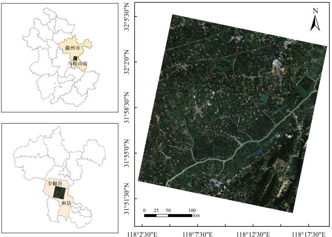
图1 安徽省滁河流域(全椒—和县段)稻虾共作典型研究区地理位置图

Fig. 1 Geographic location of the typical rice-crayfish co-culture study area in the Chu River Basin (Quanjiao Hexian Section), Anhui province

1.2 数据及预处理

本研究使用2024年泡田灌水期(2—5月)和水稻种植期(6—10月)两个物候期多景国产高分二号影像进行稻虾田提取。该卫星有4个分辨率为3.2 m的多光谱波段、1个分辨率为0.8 m的全色波段。所用数据来源于中国资源卫星应用中心陆地观测卫星数据服务平台(https://data.cresda.cn/#/2dMap)。获取的GF-2影像数据经辐射定标、大气校正及几何校正等预处理工作,并使用Gram-Schmidt方法对全色波段和多光谱波段进行图像融合,生成空间分辨率为0.8 m的高分辨率多光谱影像,为后续稻虾田识别提供高质量数据基础。

1.3 样本制作与数据增强

样本数据集是训练和评估深度学习模型的基础。本研究结合实地调查数据与不同物候期的GF-2影像,选取研究区内3块空间上互不重叠的子区域并进行人工标注,将标注后的影像与标签图裁剪为256×256像素的图像-标签对。选择其中两块区域进行模型的训练与验证,并通过图像增强(旋转、翻转等)扩充样本集,最终生成3 896对图像-标签样本,按4∶1划分为训练集与验证集。测试区域则独立选择另一块空间上未参与训练的区域,选取时综合考虑典型性与复杂性,包含多种稻虾田类型(规则、破碎、复杂边界等),以及易混淆地物(普通稻田、养殖池塘等),旨在全面评估模型在复杂环境下的泛化能力。为确保测试数据的空间独立性,测试样本未进行任何增强处理。

1.4 稻虾种养特征分析

根据《稻渔综合种养技术规范》,稻虾田是在普通稻田基础进行改造而来的20。在田块中挖宽2~4 m,深0.8~1.5 m的“口”形、“U”形、“L”形的虾沟或侧沟;其通常在主田区域种植水稻,虾沟内投养小龙虾,实现稻虾共生,见图2。其种养模式过程主要为:6月初水稻栽种,水位逐渐加深,小龙虾进入稻田实现稻虾共生;10月初收割水稻并捕捞小龙虾;10月底至次年年初,农户陆续开始泡田灌水,进行小龙虾养殖,次年5月前后收获小龙虾并进行排水,完成整田、水稻移栽等工作,进行新一轮水稻种植。因此,稻虾田整年变化呈现的状态为:水域(2—5月)-水稻(7—10月初)-水域/裸地(11月至次年1月)。稻虾田显著的物候变化特征及空间结构特征能够为稻虾田的提取提供重要依据。
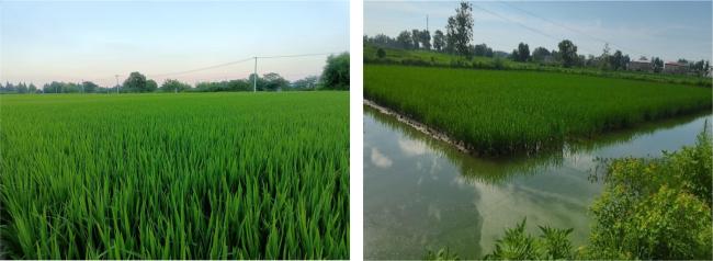
图2 普通稻田与稻虾田对比图

a. 普通稻田 b. 稻虾田

Fig. 2 Comparison between ordinary rice fields and rice-crayfish fields

2 模型方法

2.1 模型整体架构

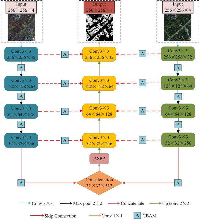
本研究充分利用稻虾田独特的时序光谱差异及空间结构特征,提出一种融合多时相遥感信息与多尺度注意力机制的双分支深度网络模型——DBAP-Net,整体结构如图3所示。该模型在传统U-Net网络26基础上进行改进。
图3 DBAP-Net模型结构

Fig. 3 DBAP-Net model structure

1)编码器部分主要采用双分支编码器,分别对不同时相影像进行特征提取。每个分支均由多层3×3卷积块与下采样操作构成,并嵌入卷积注意力机制模块(Convolutional Block Attention Module, CBAM),逐层捕捉影像的局部纹理与时序变化信息。
2)通过特征融合模块将两个分支的深层特征进行通道拼接,将融合后的特征输入空洞空间金字塔池化(Atrous Spatial Pyramid Pooling, ASPP)模块,聚合不同感受野下的上下文信息,增强模型对不同尺度、复杂形态稻虾田的适应性。
3)解码阶段,模型采用逐层上采样与跳跃连接的方式,将高层语义特征与低层细节特征相结合,逐步恢复特征图的空间分辨率,增强多尺度特征融合与空间细节恢复能力。

2.1.1 双分支编码结构

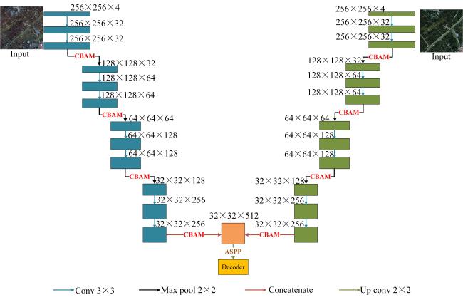
为充分挖掘稻虾田在不同物候期的光谱差异特征,本研究设计一种双分支时序编码器,如图4所示。通过构建两条参数独立但结构对称的特征提取路径,分别处理稻虾田在泡田灌水期和水稻种植期的遥感影像。每个分支均由四个层级的卷积块组成,每层包含两个3×3卷积层和2×2最大池化操作,在每一级编码块末端引入CBAM模块,每层计算如公式(1)所示。
E j i = C B A M ( φ j ( P o o l ( E j - 1 i ) ) )
式中: E j i为双分支编码器每层输出特征;i∈{1,2}表示分支;j为编码层; φ j为第j层的卷积运算。双分支编码器输出高层特征在通道维度上拼接,用于后续多尺度融合,具体如公式(2)所示。
E 4 = C o n c a t ( E 4 1 , E 4 2 )
图4 双分支编码器结构

Fig. 4 Dual-branch encoder structure

该设计能够更精准地刻画稻虾田在不同时相下的时序变化特征,有效融合时序信息,增强模型对稻虾田时序特征的表达能力。

2.1.2 卷积注意力机制模块

本研究在网络结构中引入CBAM以引导模型在通道维度和空间维度上动态调节特征权重,有效抑制与稻虾田无关的冗余信息,提升识别效果27。该模块由通道注意力和空间注意力组成:通道注意力模块对输入特征F进行空间维度压缩,通过全局平均池化和最大池化得到通道描述向量,并输入共享的多层感知机(Multilayer Perceptron, MLP)映射处理,输出元素相加后通过Sigmoid激活生成通道注意力权重,与F逐元素相乘,得到通道加权特征F′。空间注意力模块对F′在通道维度进行池化并拼接,经过7×7卷积与Sigmoid激活生成空间注意力权重,与F′相乘得到最终特征F″,如图5所示28。模型将CBAM模块嵌入编码器各级卷积模块末端及跳跃连接处,强化浅层边缘细节与深层语义信息,增强稻虾田多尺度特征表达能力。
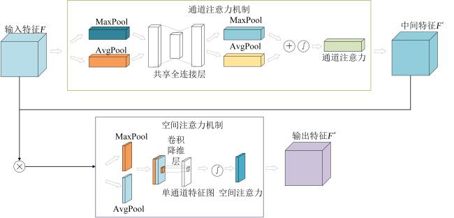
图5 卷积注意力模块结构

Fig. 5 Convolutional block attention module structure

2.1.3 多尺度特征融合模块

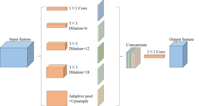
针对稻虾田田块大小各异、形状复杂多变,空间尺度差异等问题,本研究在双分支编码器输出的高层特征拼接后引入ASPP多尺度感知模块,以降低网络结构整体的特征参数29。ASPP模块由多尺度空洞卷积与全局平均池化组成,可在不同感受野范围内捕获上下文语义信息,从而兼顾局部细节与全局语义,如图6所示。通过设置多个不同膨胀率的空洞卷积(6,12,18),并行提取不同感受野范围内的上下文语义信息,同时结合1×1卷积和全局平均池化,进一步提取边缘特征与全局语义信息,提升模型对细粒度稻虾田边缘与空间结构的识别能力。
图6 空洞卷积空间金字塔结构

Fig. 6 Structure of atrous spatial pooling pyramid

2.2 模型训练及精度评价

2.2.1 实验环境与参数设置

本研究使用PyTorch框架进行模型训练,使用的显卡为NVIDIA GeForce RTX 3080 Ti(显存12 GB)。模型训练过程中使用的优化器为Adam,初始学习率设置为0.000 1,权重衰减为0.000 1,输入网络的数据大小为256×256,训练批次大小Batch Size设置为16,总训练Epoch设置为100。为解决遥感图像中类别比例不平衡的问题,采用二元交叉熵损失函数(Binary Cross-entropy Loss, BCE)30与Dice损失函数31的混合损失函数32,以平衡不同类别在训练过程中的权重,从而提高模型的性能,具体如公式(3)~公式(5)所示。同时为了避免模型过拟合应用早停(Early-Stopping, ES)策略33以防止过拟合现象。
L B C E = - 1 N i = 1 N [ y i l o g   p i + 1 - y i l o g   1 - p i ]
L D i c e = 1 - 2 i = 1 N y i p i i = 1 N y i + i = 1 N p i
L o s s = L B C E + L D i c e
式中:L BCE为二元交叉熵损失函数;L Dice为Dice损失函数;Loss为混合损失函数;yi 为第i个像素的标签值;pi 为第i个像素的预测值;N为总像素点个数。

2.2.2 评价指标

本研究用于评估模型性能的精度评价指标有总体精度(Overall Accuracy, OA)、精确率(Precision)、召回率(Recall)、F 1分数(F 1-Score, F 1)、交并比(Intersection over Union, IoU),以及马修斯相关系数(Matthews Correlation Coefficient, MCC),各指标的计算如公式(6)~公式(11)所示。此外,引入单位epoch训练时长(s/epoch)作为计算效率指标,用于反映模型在相同数据规模下的训练效率。
O A = T P + T N T P + T N + F P + F N
P r e c i s i o n = T P T P + F P
R e c a l l = T P T P + F N
F 1 = 2 × P r e c i s i o n × R e c a l l P r e c i s i o n + R e c a l l
I o U = T P T P + F P + F N
M C C = T P × T N - F P × F N T P + F N T P + F P T N + F P T N + F N
式中:TP为稻虾田像元被正确识别的数量;FP为非稻虾田像元被误判为稻虾田的数量;FN为稻虾田像元被漏检的数量;TN为背景像元被正确分类的数量。

3 结果与分析

3.1 消融实验

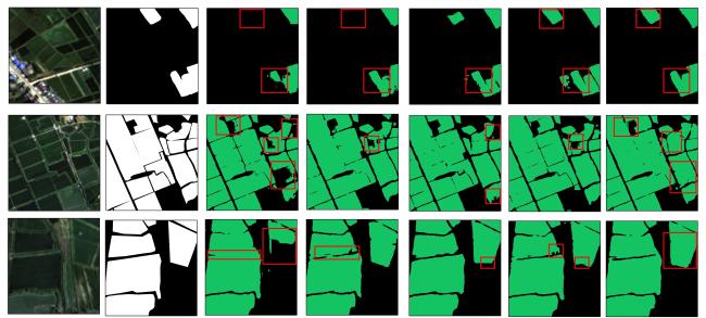
本研究提出的DBAP-Net模型的改进主要包括3部分:引入双分支网络结构、嵌入CBAM注意力模块及ASPP多尺度特征提取模块。因此本研究进行消融实验评估改进模块对于稻虾田提取的提升作用,结果如表1所示,同时图7展示了消融实验可视化结果。
表1 DBAP-Net模型消融实验结果对比

Table 1 Comparison of ablation experiment results of the DBAP-Net Model

实验序号 Dual_Brach CBAM ASPP OA/% F 1/% IoU/% MCC/%
× × × 92.62 89.24 80.57 83.62
× × 93.10 89.81 81.51 84.61
× 93.62 90.66 82.91 85.81
× 93.69 90.90 83.32 86.10
94.45 91.79 84.82 87.60

注:√表示对应实验使用该模块,×表示对应实验未使用该模块。

图7 DBAP-Net模型消融实验结果可视化

a. 影像 b. 标签 c. 实验I d. 实验Ⅱ e. 实验Ⅲ f. 实验Ⅳ g. 实验V

Fig. 7 Visualization of DBAP-Net model ablation experiment results

由实验结果可知,引入双分支编码结构(实验Ⅱ)后,漏分情况明显减少,OA、F 1、IoU和MCC较原U-Net(实验Ⅰ)分别提升0.48、0.57、0.94、0.99个百分点,表明双分支结构有效增强了时序特征判别能力;在此基础上引入CBAM模块(实验Ⅲ),各项指标较实验Ⅱ分别提升0.52、0.85、1.40、1.20个百分点,田块边界识别更为准确,错分和漏分现象进一步减少,表明该模块能够更准确地聚焦稻虾田典型空间结构,有助于更好地识别稻虾田信息;加入ASPP模块(实验Ⅳ)后,性能较实验Ⅱ分别提升0.59、1.09、1.81、1.49个百分点,验证了多尺度感受野在提取稻虾田的有效性;最终在双分支结构的基础上嵌入CBAM和ASPP(实验Ⅴ),模型精度达到最优,各项指标分别为94.45%、91.79%、84.82%和87.60%,较原U-Net(实验Ⅰ)分别提升1.83、2.55、4.25、3.98个百分点,其能同时保证对局部边界的精细刻画,以及对整体区域的完整识别,有效缓解“同物异谱”与“同谱异物”问题。整个消融实验表明DBAP-Net模型每个模块的加入,对稻虾田提取精度提升均具有促进作用。

3.2 对比实验

本研究将DBAP-Net与U-Net、PSPNet、DeepLabV3+、SegFormer、TransUNet这5种语义分割模型进行对比,以评估其在稻虾田识别任务中的效果。各模型均在统一的数据和参数配置下运行,实验结果见表2所示。从总体结果来看,DBAP-Net模型的稻虾田识别在综合性能上表现最优。具体来说,该模型的总体精度达到94.45%,F 1为91.79%,交并比为84.82%,MCC为87.60%。与PSPNet、DeepLabV3+及SegFormer相比,F 1分别提升2.98、2.75、3.09个百分点,IoU分别提升4.96、4.57、5.12个百分点。相比U-Net和TransUNet,F 1分别提高2.55、1.67个百分点,IoU分别提高4.25、2.81个百分点,MCC分别提升3.98、2.73个百分点。同时该模型计算效率适中,能够较好地实现精度与效率之间的良好平衡。
表2 不同模型稻虾田提取结果对比

Table 2 Comparison of different models for rice-crayfish field extraction

模型 OA/% Precision/% F 1/% Recall/% IoU/% MCC/% s/epoch
U-Net 92.62 88.81 89.24 89.67 80.57 83.62 98.09
PSP-Net 92.36 88.84 88.81 88.77 79.86 83.00 86.61
DeepLabV3+ 92.66 90.82 89.04 87.33 80.25 83.57 90.96
SegFormer 92.38 89.85 88.70 87.59 79.70 82.98 134.07
TransUNet 93.10 88.22 90.12 92.10 82.01 84.87 115.10
DBAP-Net 94.45 92.68 91.79 90.91 84.82 87.60 106.97
各模型对稻虾田的提取结果如图8所示,DBAP-Net模型分割结果最佳,该模型与实际样本具有较高的一致性,稻虾田田块边界匹配良好。SegFormer分割效果最差,存在大量漏分及错分现象;PSPNet、DeepLabV3+采用单一尺度的特征提取方式,对稻虾田复杂时空特征的适应性较弱,导致分割结果出现明显错分漏分现象,部分田块存在空洞、破碎及边界模糊等问题,提取结果完整性较差;同时U-Net模型也存在明显的错分漏分;TransUNet分割效果较好,但仍存在部分错分漏分问题。综合来看,DBAP-Net模型分割结果最优,在精度与边界完整性方面均优于其他模型。
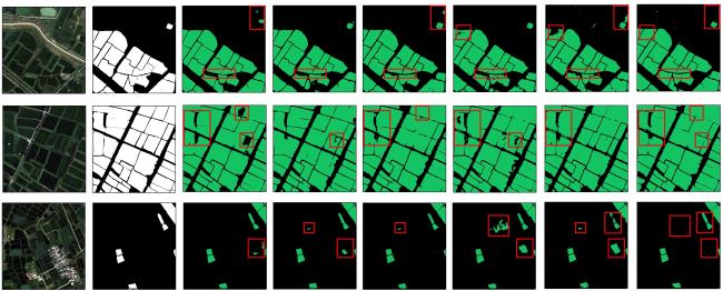
图8 各模型稻虾田提取结果可视化

a. 影像 b. 标签 c. U-Net d. PSPNet e. DeepLabV3+ f. SegFormer g. TransUNet h. DBAP-Net

Fig. 8 Visualization of extraction results by each model

3.3 结果应用

在大尺度区域范围内运用训练好的模型,得到研究区稻虾田空间分布,如图9所示。可以看出,研究区内稻虾田在空间上主要分布于中部地区,特别是沿滁河两岸集中分布,且地块形态规整,面积相对较大,北部及西北部地区稻虾田分布较为零散,呈斑块状分布,地块相对较小。从整体空间分布格局看,稻虾田的空间分布具有一定的集聚性。
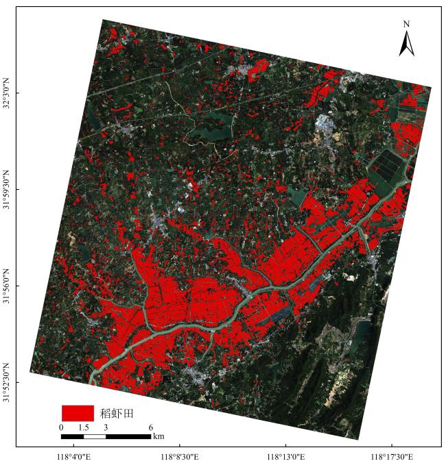
图9 DBAP-Net模型稻虾田提取结果

Fig. 9 Extraction results of DBAP-Net model rice-crayfish fields

为验证本研究提出的深度学习模型在稻虾田识别中的优越性,对照多时相GF-2影像进行目视解译,共选取了1 449个真实的验证样点,其中稻虾田样点781个,非稻虾田样点668个(普通稻田、藕田、养殖池塘、普通水体、建筑等),利用生产者精度(Producer's Accuracy, PA)、用户精度(User's Accuracy, UA)、OA及Kappa系数等指标,与传统稻虾田提取方法(水体季相差异法19、随机森林法17、时序指数阈值法34)对比,结果如表3所示。实验结果表明:本研究方法的所有评估指标均显著优于3种传统方法,其PA、UA、OA、Kappa分别达到95.13%、97.38%、96.00%、0.920,该方法表现出更强的地物判别能力,在稻虾田的提取中具有较大的优势。
表3 各方法稻虾田提取结果

Table 3 Extraction results of rice-crayfish fields by methods

方法 PA/% UA/% OA/% Kappa
水体季相差异 83.61 89.94 86.13 0.723
随机森林 88.09 83.39 84.13 0.679
时序指数阈值 85.92 90.55 87.58 0.751
DBAP-Net 95.13 97.38 96.00 0.920
选择地形复杂、种植结构多样的典型区域进行可视化展示,进一步验证本研究方法在提取效果上的优越性,如图10所示。可以看出,本研究方法提取结果错分率与漏分率均极低,同时提取的稻虾田田块也更完整,较少出现稻虾田田块之间的粘连现象。相较于本研究方法,3种传统方法均存在将藕田、普通稻田、水体等错分成稻虾田的现象。同时,水体季相差异法依靠单一的水体指数进行阈值分类,稳定性与泛化能力有限,识别结果存在较大不确定性,稻虾田存在较明显漏分现象,且存在一定的缺陷—无法识别稻虾田内的“虾沟”区域,对稻虾田田块识别不完整;随机森林方法识别结果存在较为严重的稻虾田田块粘连现象,稻虾田边界不清晰;时序指数阈值法更依赖于阈值的选取,同样存在少量漏分情况。DBAP-Net深度学习方法在田块分类细节上表现得较为规整,边界提取更为完整和准确。
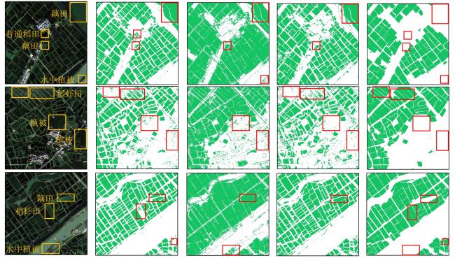
图10 各方法稻虾田提取结果可视化

a. 影像 b. 水体季相差异 c. 随机森林 d. 时序指数阈值 e. DBAP-Net

Fig. 10 Visualization of extraction results in rice-crayfish fields by methods

4 结 论

为了实现稻虾田的高精度遥感提取,准确地掌握稻虾田的空间分布信息,本研究提出了一种实现稻虾田高精度提取的DBAP-Net深度网络模型。模型引入双分支编码结构,充分挖掘不同物候期的时序光谱差异特征,提升时序特征表达能力;结合ASPP模块与CBAM机制,提升模型对稻虾田空间结构的识别能力,最终实现稻虾田的最优提取效果,为稻虾田的高精度遥感监测提供技术支撑。主要结论如下:
1)DBAP-Net模型在稻虾田遥感识别中表现优异。与U-Net、PSPNet、DeepLabV3+、SegFormer、TransUNet等经典语义分割模型相比,DBAP-Net模型综合性能表现最优。与次优模型TransUNet相比,F 1分数、IoU和MCC分别提高了1.67、2.81、2.73个百分点,同时消融实验验证了每个模块对提取结果均有促进作用。
2)将DBAP-Net模型应用于研究区全域,生产精度为95.13%,用户精度达到97.38%,总体精确度达96.00%,Kappa系数为0.920。与传统的水体季相差异法、随机森林法,以及时序指数阈值法相比,该方法提升效果显著,提取结果更精细完整,较少出现相邻稻虾田粘连现象。
本研究构建的DBAP-Net深度网络模型,充分融合多时相光谱信息与空间结构特征,对作物类型复杂的地区提取效果显著。该方法能够有效区分普通稻田、藕田等与稻虾田相似特征的地物,提取完整的稻虾田田块,有效解决了传统方法中“异物同谱”、稻虾田提取不精细、边界模糊,以及粘连识别等问题,为稻虾田的精细提取提供一种思路和方法。
但不可否认的是,尽管此模型在复杂区域中提取效果显著,但在实际推广应用中仍存在一定局限性:1)模型依赖GF-2高分辨率影像,其时间分辨率较低,难以满足长时序动态监测需求,且在多云多雨地区易受气象条件限制;2)深度学习方法需要大量高质量标注样本,稻虾田的精细标注需耗费大量人力物力,尤其在复杂种植区域,样本的不均衡性影响模型泛化能力;3)受遥感数据获取条件所限,本研究未在其他地区开展迁移实验,模型在不同地理环境和种养模式下的适用性尚需验证。因此,未来的研究重点将考虑与Sentinel系列影像等多源遥感数据融合,并尝试引入弱监督或无监督学习方法,进一步优化算法,提高模型的实用性和泛化能力,从而实现长时序、大区域稻虾田空间分布信息的高精度提取。


本研究不存在研究者以及与公开研究成果有关的利益冲突。

[1]
夏天, 武星华, 周晓, 等. "虾稻"模式下粮食安全—经济发展—生态保护三维系统综合效益: 以湖北潜江市为例[J]. 经济地理, 2024, 44(8): 170-180.

XIA T, WU X H, ZHOU X, et al. Comprehensive benefits of the three-dimensional system of food security, economic development, and ecological protection under the rice-crayfish co-cropping model: A case study of Qianjiang city in Hubei province[J]. Economic geography, 2024, 44(8): 170-180.

[2]
周国华, 龙花楼, 林万龙, 等. 新时代“三农”问题和乡村振兴的理论思考与实践发展[J]. 自然资源学报, 2023, 38(8): 1919-1940.

ZHOU G H, LONG H L, LIN W L, et al. Theoretical thinking and practical development of "Three Rural Issues" and rural revitalization in the new era[J]. Journal of natural resources, 2023, 38(8): 1919-1940.

[3]
唐健飞, 刘剑玲. 省域农业可持续发展水平评价及其耦合协调分析: 以长江经济带11省市为例[J]. 经济地理, 2022, 42(12): 179-185.

TANG J F, LIU J L. Evaluation and coupling coordination analysis of provincial agricultural sustainable development: A case of 11 provinces in the Yangtze River economic belt[J]. Economic geography, 2022, 42(12): 179-185.

[4]
王松良, 施生旭. 发展中国生态农业是实现中国式农业现代化的根本路径: 兼论生态农业在我国兴起与发展的“前世今生”[J]. 中国生态农业学报(中英文), 2023, 31(8): 1184-1193.

WANG S L, SHI S X. Developing Chinese ecological agriculture acts as a vital pathway of the statespecifically agricultural modernization in China: A historical review of ecological agriculture movement in China[J]. Chinese journal of eco-agriculture, 2023, 31(8): 1184-1193.

[5]
LAO A R, AVISO K B, CABEZAS H, et al. Maintaining the productivity of co-culture systems in the face of environmental change[J]. Nature sustainability, 2022, 5(9): 749-752.

[6]
LIU B B, GU W Y, YANG Y, et al. Promoting potato as staple food can reduce the carbon-land-water impacts of crops in China[J]. Nature food, 2021, 2(8): 570-577.

[7]
SHEN G, YU Q Y, ZHOU Q B, et al. From multiple cropping frequency to multiple cropping system: A new perspective for the characterization of cropland use intensity[J]. Agricultural systems, 2023, 204: ID 103535.

[8]
FAN L M, LI F J, CHEN X, et al. Co-culture of red swamp crayfish Procambarus clarkia influenced glycoside hydrolase families and fungal communities in the rice-paddy soils[J]. Applied soil ecology, 2023, 186: ID 104816.

[9]
XU Q, DAI L X, SHANG Z Y, et al. Application of controlled-release urea to maintain rice yield and mitigate greenhouse gas emissions of rice-crayfish coculture field[J]. Agriculture, ecosystems & environment, 2023, 344: ID 108312.

[10]
夏天, 吴婕妤, 朱媛媛, 等. 中国中部重点农区虾稻田的时空演变及地域模式[J]. 经济地理, 2023, 43(6): 183-191.

XIA T, WU J Y, ZHU Y Y, et al. Spatio-temporal evolution and regional development model of rice-crayfish fields in main agricultural production regions of Central China[J]. Economic geography, 2023, 43(6): 183-191.

[11]
陈松文, 曹凑贵, 郝向举, 等. 中国稻虾种养: 产业现状与绿色高质量发展对策[J]. 农业现代化研究, 2023, 44(4): 575-587.

CHEN S W, CAO C G, HAO X J, et al. Rice-crayfish farming in China: Current industry status and strategies for the further development of high-quality green farming[J]. Research of agricultural modernization, 2023, 44(4): 575-587.

[12]
XU Q, PENG X, GUO H L, et al. Rice-crayfish coculture delivers more nutrition at a lower environmental cost[J]. Sustainable production and consumption, 2022, 29: 14-24.

[13]
JIANG Y, CAO C G. Crayfish–rice integrated system of production: An agriculture success story in China. A review[J]. Agronomy for sustainable development, 2021, 41(5): ID 68.

[14]
倪明理, 邓凯, 张文宇, 等. 稻虾种养对水稻产量和粮食安全的影响[J]. 中国生态农业学报(中英文), 2022, 30(8): 1293-1300.

NI M L, DENG K, ZHANG W Y, et al. Effects of rice-crayfish coculture on rice yield and food security[J]. Chinese journal of eco-agriculture, 2022, 30(8): 1293-1300.

[15]
JIN T, GE C D, GAO H, et al. Evaluation and screening of co-culture farming models in rice field based on food productivity[J]. Sustainability, 2020, 12(6): ID 2173.

[16]
鄂海林, 周德成, 李坤. 基于Sentinel 1/2和GEE的水稻种植面积提取方法: 以杭嘉湖平原为例[J]. 智慧农业(中英文), 2025, 7(2): 81-94.

E H L, ZHOU D C, LI K. Extracting method of the cultivation aera of rice based on sentinel-1/2 and google earth engine (GEE): A case study of the hangjiahu plain[J]. Smart agriculture, 2025, 7(2): 81-94.

[17]
WANG C, WANG G H, ZHANG G L, et al. Freshwater aquaculture mapping in "home of Chinese crawfish" by using a hierarchical classification framework and sentinel-1/2 data[J]. Remote sensing, 2024, 16(5): ID 893.

[18]
魏浩东, 杨靖雅, 蔡志文, 等. 物候窗口和多源中高分辨率影像的稻虾田提取[J]. 遥感学报, 2022, 26(7): 1423-1436.

WEI H D, YANG J Y, CAI Z W, et al. Phenology windows and multi-source medium-/ high-resolution image extraction for rice-crayfish paddy fields mapping[J]. National remote sensing bulletin, 2022, 26(7): 1423-1436.

[19]
魏妍冰, 陆苗, 吴文斌. 基于水体季相差异的稻虾共作提取方法研究[J]. 中国农业资源与区划, 2019, 40(3): 14-20, 34.

WEI Y B, LU M, WU W B. Study on extraction method of rice-crayfish based on seasonal difference of water[J]. Chinese journal of agricultural resources and regional planning, 2019, 40(3): 14-20, 34.

[20]
董秀春, 蒋怡, 李宗南, 等. 基于Sentinel-1时序数据的稻虾田遥感识别[J]. 遥感技术与应用, 2024, 39(2): 306-314.

DONG X C, JIANG Y, LI Z N, et al. Remote Sensing identification of rice-crayfish fields using sentinel-1 time series[J]. Remote sensing technology and application, 2024, 39(2): 306-314.

[21]
MA S Q, WANG D Y, YANG H C, et al. A bi-temporal-feature-difference- and object-based method for mapping rice-crayfish fields in Sihong, China[J]. Remote sensing, 2023, 15(3): ID 658.

[22]
XIA T, JI W W, LI W D, et al. Phenology-based decision tree classification of rice-crayfish fields from Sentinel-2 imagery in Qianjiang, China[J]. International journal of remote sensing, 2021, 42(21): 8124-8144.

[23]
WEI H D, HU Q, CAI Z W, et al. An object- and topology-based analysis (OTBA) method for mapping rice-crayfish fields in South China[J]. Remote sensing, 2021, 13(22): ID 4666.

[24]
查鸿伟, 李浩, 朱益虎, 等. 利用边缘辅助分割网络提取稻虾共作养殖田[J]. 农业工程学报, 2023, 39(19): 154-164.

ZHA H W, LI H, ZHU Y H, et al. Extraction of rice and shrimp co-cultivation farming fields using edge-assisted segmentation network[J]. Transactions of the Chinese society of agricultural engineering, 2023, 39(19): 154-164.

[25]
刘巍, 吴志峰, 骆剑承, 等. 深度学习支持下的丘陵山区耕地高分辨率遥感信息分区分层提取方法[J]. 测绘学报, 2021, 50(1): 105-116.

LIU W, WU Z F, LUO J C, et al. A divided and stratified extraction method of high-resolution remote sensing information for cropland in hilly and mountainous areas based on deep learning[J]. Acta geodaetica et cartographica sinica, 2021, 50(1): 105-116.

[26]
RONNEBERGER O, FISCHER P, BROX T. U-Net: Convolutional networks for biomedical image segmentation[C]// Medical Image Computing and Computer-Assisted Intervention–MICCAI 2015. Cham, Germany: Springer, 2015: 234-241.

[27]
SEYDI S T, AMANI M, GHORBANIAN A. A dual attention convolutional neural network for crop classification using time-series sentinel-2 imagery[J]. Remote sensing, 2022, 14(3): ID 498.

[28]
严从宽, 朱德泉, 孟凡凯, 等. 基于改进CycleGAN的水稻叶片病害图像增强方法[J]. 智慧农业(中英文), 2024, 6(6): 96-108.

YAN C K, ZHU D Q, MENG F K, et al. Rice leaf disease image enhancement based on improved CycleGAN[J]. Smart agriculture, 2024, 6(6): 96-108.

[29]
WANG X L, GIRSHICK R, GUPTA A, et al. Non-local neural networks[C]// 2018 IEEE/CVF Conference on Computer Vision and Pattern Recognition. Piscataway, New Jersey, USA: IEEE, 2018: 7794-7803.

[30]
KANG J, FERNANDEZ-BELTRAN R, HONG D F, et al. Graph relation network: Modeling relations between scenes for multilabel remote-sensing image classification and retrieval[J]. IEEE transactions on geoscience and remote sensing, 2021, 59(5): 4355-4369.

[31]
HUANG Z Q, YOU H J. MFSFNet: Multi-scale feature subtraction fusion network for remote sensing image change detection[J]. Remote sensing, 2023, 15(15): ID 3740.

[32]
LI X H, HE M Z, LI H F, et al. A combined loss-based multiscale fully convolutional network for high-resolution remote sensing image change detection[J]. IEEE geoscience and remote sensing letters, 2022, 19: ID 8017505.

[33]
PENG M, LIU Y X, KHAN A, et al. Crop monitoring using remote sensing land use and land change data: Comparative analysis of deep learning methods using pre-trained CNN models[J]. Big data research, 2024, 36: ID 100448.

[34]
SHAO Q H, LI R D, QIU J, et al. Large-scale mapping of new mixed rice cropping patterns in Southern China with phenology-based algorithm and MODIS dataset[J]. Paddy and water environment, 2023, 21(2): 243-261.

Outlines

/