Smart Agriculture ›› 2025, Vol. 7 ›› Issue (6): 185-195.doi: 10.12133/j.smartag.SA202507032
• Special Issue--Remote Sensing + AI Empowering the Modernization of Agriculture and Rural Areas • Previous Articles Next Articles
ZHANG Yun1,2, ZHANG Lumin1,2, XU Guangtao1,2, HAO Jiahui1,2
Received:2025-07-23
Online:2025-11-30
Foundation items:National Major Science and Technology Project of China High-resolution Earth Observation System(76-Y50G14-0038-22/23)
corresponding author:
CLC Number:
ZHANG Yun, ZHANG Lumin, XU Guangtao, HAO Jiahui. Remote Sensing Extraction Method of Rice-Crayfish Fields Based on Dual-Branch and Multi-Scale Attention[J]. Smart Agriculture, 2025, 7(6): 185-195.
Add to citation manager EndNote|Ris|BibTeX
URL: https://www.smartag.net.cn/EN/10.12133/j.smartag.SA202507032
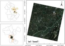
Fig. 1
Geographic location of the typical rice-crayfish co-culture study area in the Chu River Basin (Quanjiao Hexian Section), Anhui province


Fig. 2
Comparison between ordinary rice fields and rice-crayfish fields

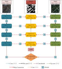
Fig. 3
DBAP-Net model structure

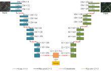
Fig. 4
Dual-branch encoder structure


Fig. 5
Convolutional block attention module structure

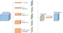
Fig. 6
Structure of atrous spatial pooling pyramid

Table 1
Comparison of ablation experiment results of the DBAP-Net Model
| 实验序号 | Dual_Brach | CBAM | ASPP | OA/% | F 1/% | IoU/% | MCC/% |
|---|---|---|---|---|---|---|---|
| Ⅰ | × | × | × | 92.62 | 89.24 | 80.57 | 83.62 |
| Ⅱ | √ | × | × | 93.10 | 89.81 | 81.51 | 84.61 |
| Ⅲ | √ | √ | × | 93.62 | 90.66 | 82.91 | 85.81 |
| Ⅳ | √ | × | √ | 93.69 | 90.90 | 83.32 | 86.10 |
| Ⅴ | √ | √ | √ | 94.45 | 91.79 | 84.82 | 87.60 |
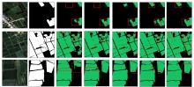
Fig. 7
Visualization of DBAP-Net model ablation experiment results

Table 2
Comparison of different models for rice-crayfish field extraction
| 模型 | OA/% | Precision/% | F 1/% | Recall/% | IoU/% | MCC/% | s/epoch |
|---|---|---|---|---|---|---|---|
| U-Net | 92.62 | 88.81 | 89.24 | 89.67 | 80.57 | 83.62 | 98.09 |
| PSP-Net | 92.36 | 88.84 | 88.81 | 88.77 | 79.86 | 83.00 | 86.61 |
| DeepLabV3+ | 92.66 | 90.82 | 89.04 | 87.33 | 80.25 | 83.57 | 90.96 |
| SegFormer | 92.38 | 89.85 | 88.70 | 87.59 | 79.70 | 82.98 | 134.07 |
| TransUNet | 93.10 | 88.22 | 90.12 | 92.10 | 82.01 | 84.87 | 115.10 |
| DBAP-Net | 94.45 | 92.68 | 91.79 | 90.91 | 84.82 | 87.60 | 106.97 |
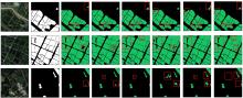
Fig. 8
Visualization of extraction results by each model

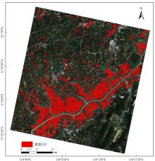
Fig. 9
Extraction results of DBAP-Net model rice-crayfish fields

Table 3
Extraction results of rice-crayfish fields by methods
| 方法 | PA/% | UA/% | OA/% | Kappa |
|---|---|---|---|---|
| 水体季相差异 | 83.61 | 89.94 | 86.13 | 0.723 |
| 随机森林 | 88.09 | 83.39 | 84.13 | 0.679 |
| 时序指数阈值 | 85.92 | 90.55 | 87.58 | 0.751 |
| DBAP-Net | 95.13 | 97.38 | 96.00 | 0.920 |
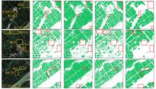
Fig. 10
Visualization of extraction results in rice-crayfish fields by methods

| [1] |
夏天, 武星华, 周晓, 等. "虾稻"模式下粮食安全—经济发展—生态保护三维系统综合效益: 以湖北潜江市为例[J]. 经济地理, 2024, 44(8): 170-180.
|
|
|
|
| [2] |
周国华, 龙花楼, 林万龙, 等. 新时代“三农”问题和乡村振兴的理论思考与实践发展[J]. 自然资源学报, 2023, 38(8): 1919-1940.
|
|
|
|
| [3] |
唐健飞, 刘剑玲. 省域农业可持续发展水平评价及其耦合协调分析: 以长江经济带11省市为例[J]. 经济地理, 2022, 42(12): 179-185.
|
|
|
|
| [4] |
王松良, 施生旭. 发展中国生态农业是实现中国式农业现代化的根本路径: 兼论生态农业在我国兴起与发展的“前世今生”[J]. 中国生态农业学报(中英文), 2023, 31(8): 1184-1193.
|
|
|
|
| [5] |
|
| [6] |
|
| [7] |
|
| [8] |
|
| [9] |
|
| [10] |
夏天, 吴婕妤, 朱媛媛, 等. 中国中部重点农区虾稻田的时空演变及地域模式[J]. 经济地理, 2023, 43(6): 183-191.
|
|
|
|
| [11] |
陈松文, 曹凑贵, 郝向举, 等. 中国稻虾种养: 产业现状与绿色高质量发展对策[J]. 农业现代化研究, 2023, 44(4): 575-587.
|
|
|
|
| [12] |
|
| [13] |
|
| [14] |
倪明理, 邓凯, 张文宇, 等. 稻虾种养对水稻产量和粮食安全的影响[J]. 中国生态农业学报(中英文), 2022, 30(8): 1293-1300.
|
|
|
|
| [15] |
|
| [16] |
鄂海林, 周德成, 李坤. 基于Sentinel 1/2和GEE的水稻种植面积提取方法: 以杭嘉湖平原为例[J]. 智慧农业(中英文), 2025, 7(2): 81-94.
|
|
|
|
| [17] |
|
| [18] |
魏浩东, 杨靖雅, 蔡志文, 等. 物候窗口和多源中高分辨率影像的稻虾田提取[J]. 遥感学报, 2022, 26(7): 1423-1436.
|
|
|
|
| [19] |
魏妍冰, 陆苗, 吴文斌. 基于水体季相差异的稻虾共作提取方法研究[J]. 中国农业资源与区划, 2019, 40(3): 14-20, 34.
|
|
|
|
| [20] |
董秀春, 蒋怡, 李宗南, 等. 基于Sentinel-1时序数据的稻虾田遥感识别[J]. 遥感技术与应用, 2024, 39(2): 306-314.
|
|
|
|
| [21] |
|
| [22] |
|
| [23] |
|
| [24] |
查鸿伟, 李浩, 朱益虎, 等. 利用边缘辅助分割网络提取稻虾共作养殖田[J]. 农业工程学报, 2023, 39(19): 154-164.
|
|
|
|
| [25] |
刘巍, 吴志峰, 骆剑承, 等. 深度学习支持下的丘陵山区耕地高分辨率遥感信息分区分层提取方法[J]. 测绘学报, 2021, 50(1): 105-116.
|
|
|
|
| [26] |
|
| [27] |
|
| [28] |
严从宽, 朱德泉, 孟凡凯, 等. 基于改进CycleGAN的水稻叶片病害图像增强方法[J]. 智慧农业(中英文), 2024, 6(6): 96-108.
|
|
|
|
| [29] |
|
| [30] |
|
| [31] |
|
| [32] |
|
| [33] |
|
| [34] |
|
| [1] | WU Zhangbin, HE Ning, WU Yandong, GUO Xinyu, WEN Weiliang. Point Cloud Data-driven Methods for Estimating Maize Leaf Biomass [J]. Smart Agriculture, 2026, 8(1): 156-166. |
| [2] | HU Yumeng, GUAN Feifan, XIE Dongchen, MA Ping, YU Youben, ZHOU Jie, NIE Yanming, HUANG Lüwen. Tea Leaf Disease Diagnosis Based on Improved Lightweight U-Net3+ [J]. Smart Agriculture, 2026, 8(1): 15-27. |
| [3] | YAO Xiaotong, QU Shaoye. Lightweight Detection Method for Pepper Leaf Diseases and Pests Based on Improved YOLOv12s [J]. Smart Agriculture, 2026, 8(1): 1-14. |
| [4] | SONG Mingxuan, BAI Bo, YANG Juntao, ZHANG Yutao, LI Sa, LI Zhenhai, WAN Shubo, LI Guowei. Robust UAV-Based Method for Peanut Plant Height Estimation Using Bare-Soil Invariant Constraints [J]. Smart Agriculture, 2025, 7(6): 124-135. |
| [5] | SUN Rong, GAO Han, JIANG Yujie, LI Qiaochu, WU Haoyu, WU Shangrong, YU Shan, XU Lei, YU Liangliang, ZHANG Jie, BAO Yuhai. Progress in Soil Moisture Retrieval under Crop Canopy Cover Based on Multi-polarization SAR Data [J]. Smart Agriculture, 2025, 7(6): 75-95. |
| [6] | LU Yihang, DONG Wen, ZHANG Xin, YAN Ruoyi, ZHANG Yujia, TANG Tao. Physics-Constrained PROSAIL-cGAN Approach for Spectral Sample Augmentation and LAI Inversion of Winter Wheat [J]. Smart Agriculture, 2025, 7(6): 149-160. |
| [7] | WANG Yinhui, ZHAO Anzhou, LI Dan, ZHU Xiufang, ZHAO Jun, WANG Ziqing. Construction and Evaluation of Lightweight and Interpretable Soybean Remote Sensing Identification Model [J]. Smart Agriculture, 2025, 7(6): 136-148. |
| [8] | LONG Yuqiao, SUN Jing, WEN Yanru, WANG Chuya, DONG Xiuchun, HUANG Ping, WU Wenbin, CHEN Jin, DING Mingzhong. Remote Sensing Approaches for Cropland Abandonment Perception in Southern Hilly and Mountainous Areas of China: A Review [J]. Smart Agriculture, 2025, 7(6): 58-74. |
| [9] | ZHAO Jun, NIE Zhigang, LI Guang, LIU Jiayu. Corn Borer Pests Infestations Detection Method Using Low-Altitude Close-Range UAV Imagery [J]. Smart Agriculture, 2025, 7(6): 111-123. |
| [10] | LI Wenzheng, YANG Xinting, SUN Chuanheng, CUI Tengpeng, WANG Hui, LI Shanshan, LI Wenyong. Light-Trapping Rice Planthopper Detection Method by Combining Spatial Depth Transform Convolution and Multi-scale Attention Mechanism [J]. Smart Agriculture, 2025, 7(5): 169-181. |
| [11] | HAN Wenkai, LI Tao, FENG Qingchun, CHEN Liping. Lightweight Apple Instance Segmentation Algorithm Based on SSW-YOLOv11n for Complex Orchard Environments [J]. Smart Agriculture, 2025, 7(5): 114-123. |
| [12] | WANG Fengyun, WANG Xuanyu, AN Lei, FENG Wenjie. Detection Method for Log-Cultivated Shiitake Mushrooms Based on Improved RT-DETR [J]. Smart Agriculture, 2025, 7(5): 67-77. |
| [13] | ZHAO Yingping, LIANG Jinming, CHEN Beizhang, DENG Xiaoling, ZHANG Yi, XIONG Zheng, PAN Ming, MENG Xiangbao. Applications Research Progress and Prospects of Multi-Agent Large Language Models in Agricultural [J]. Smart Agriculture, 2025, 7(5): 37-51. |
| [14] | HU Yan, WANG Yujie, ZHANG Xuechen, ZHANG Yiqiang, YU Huahao, SONG Xinbei, YE Sitan, ZHOU Jihong, CHEN Zhenlin, ZONG Weiwei, HE Yong, LI Xiaoli. Non-Destructive Inspection and Intelligent Grading Method of Fu Brick Tea at Fungal Fermentation Stage Based on Hyperspectral Imaging Technology [J]. Smart Agriculture, 2025, 7(4): 71-83. |
| [15] | LI Ruijie, WANG Aidong, WU Huaxing, LI Ziqiu, FENG Xiangqian, HONG Weiyuan, TANG Xuejun, QIN Jinhua, WANG Danying, CHU Guang, ZHANG Yunbo, CHEN Song. Remote Sensing for Rice Growth Stages Monitoring: Research Progress, Bottleneck Problems and Technical Optimization Paths [J]. Smart Agriculture, 2025, 7(3): 89-107. |
| Viewed | ||||||
|
Full text |
|
|||||
|
Abstract |
|
|||||


