Smart Agriculture ›› 2025, Vol. 7 ›› Issue (2): 117-131.doi: 10.12133/j.smartag.SA202502005
• Topic--Development and Application of the Big Data Platform for Grain Production • Previous Articles Next Articles
WEI Yuxin1,2, LI Qiao1,2( ), TAO Hongfei1,2, LU Chunlei3, LUO Xu4, MAHEMUJIANG Aihemaiti1,2, JIANG Youwei1,2
Received:2025-01-27
Online:2025-03-30
Foundation items:Major Project of Xinjiang Uygur Autonomous Region(2023A02002-1); National Natural Science Foundation of China(41762018)
About author:corresponding author:
CLC Number:
WEI Yuxin, LI Qiao, TAO Hongfei, LU Chunlei, LUO Xu, MAHEMUJIANG Aihemaiti, JIANG Youwei. Agricultural Drought Monitoring in Arid Irrigated Areas Based on TVDI Combined with ICEEMDAN-ARIMA Model[J]. Smart Agriculture, 2025, 7(2): 117-131.
Add to citation manager EndNote|Ris|BibTeX
URL: https://www.smartag.net.cn/EN/10.12133/j.smartag.SA202502005
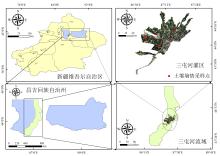
Fig. 1
Santun river irrigation area in Xinjiang

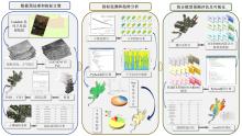
Fig. 2
Data preprocessing and main research workflow of agricultural drought monitoring research in arid irrigation areas based on TVDI combined with ICEEMDAN-ARIMA model

Table 1
Drought classification criteria based on different drought indices
| 干旱等级 | TVDI | VTCI |
|---|---|---|
| 无旱 | [0.00,0.60] | (0.55,1.00] |
| 轻度干旱 | (0.60,0.71] | (0.41,0.55] |
| 中度干旱 | (0.71,0.76] | (0.29,0.41] |
| 重度干旱 | (0.76,0.85] | (0.21,0.29] |
| 极端干旱 | (0.85,1.00] | [0.00,0.21] |
Table 2
Classification standard of Mann-Kendall trend test
| 趋势度β | 统计量|Z| | 趋势分类 |
|---|---|---|
| β>0 | 2.58<|Z| | 极显著变旱 |
| 1.96<|Z|≤2.58 | 显著变旱 | |
| 1.96≥|Z| | 轻微变旱 | |
| β<0 | 1.96≥|Z| | 轻微缓解 |
| 1.96<|Z|≤2.58 | 显著缓解 | |
| 2.58<|Z| | 极显著缓解 |
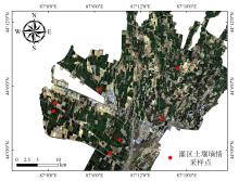
Fig. 3
Sampling points of measured soil moisture content in Santun river irrigation area

Table 3
Linear fitting results of TVDI/VTCI and 0-10 cm measured soil water content
| 日期 | TVDI拟合方程 | R 2 | VTCI拟合方程 | R 2 |
|---|---|---|---|---|
| 5月3日 | SM=0.50-0.39TVDI | 0.61 | SM=12.07+55.99VTCI | 0.330 |
| 6月4日 | SM=0.55-0.44TVDI | 0.58 | SM=24.08-6.72VTCI | 0.016 |
| 6月20日 | SM=0.50-0.39TVDI | 0.59 | SM=10.66+33.14VTCI | 0.120 |
| 7月22日 | SM=1.08-1.27TVDI | 0.51 | SM=28.90-10.97VTCI | 0.070 |
| 8月7日 | SM=0.68-0.63TVDI | 0.66 | SM=9.06+26.70VTCI | 0.280 |
| 整体 | SM=0.54-0.45TVDI | 0.57 | SM=21.31+2.75VTCI | 0.005 |
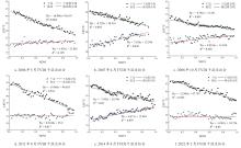
Fig. 4
Multi-temporal TVDI dry and wet edge fitting in Santun river irrigation area, Xinjiang, from 2005 to 2022

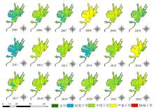
Fig. 5
Spatial distribution of temperature vegetation drought index in Santun river irrigation area, Xinjiang, from 2005 to 2022

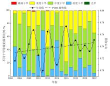
Fig. 6
Interannual variation of TVDI and area proportion of different drought grades in Santun river irrigation area from 2005 to 2022

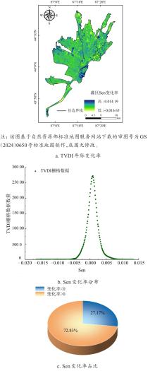
Fig. 7
Interannual variation rate and distribution proportion of TVDI in Santun river irrigation area, Xinjiang, from 2005 to 2022

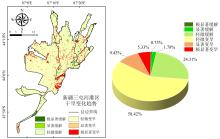
Fig. 8
Trend type and area proportion of drought change in Santun river irrigation area, Xinjiang, from 2005 to 2022
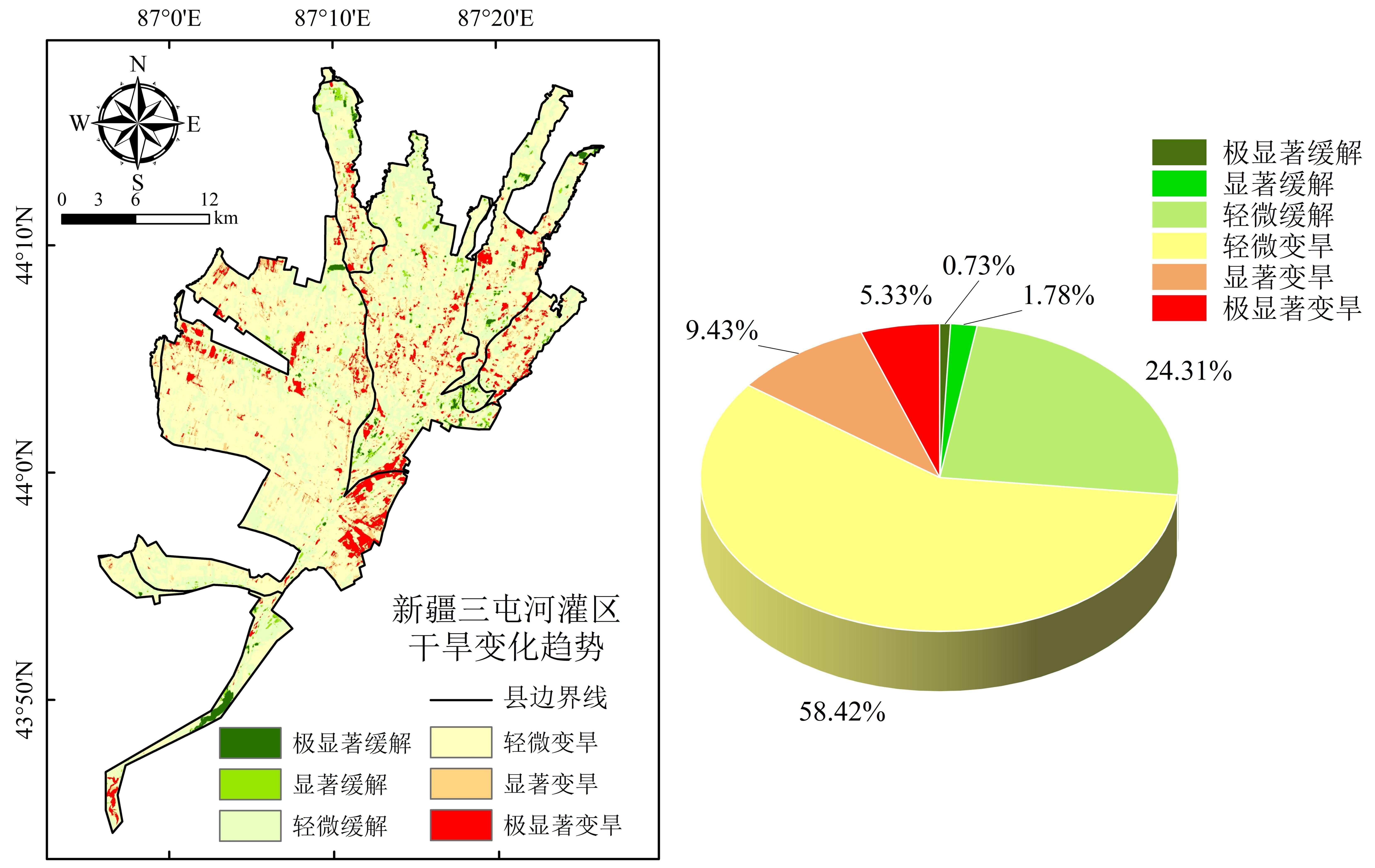
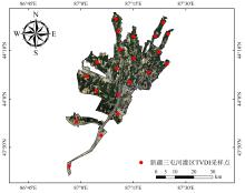
Fig. 9
TVDI data sampling points of the ICEEMDAN-ARIMA combined model in Santun river irrigation area, Xinjiang

Table 4
Component order of ICEEMDAN-ARIMA combination model at different sampling points
| 采样点编号 | 分量 | 模型(p, d, q) | AIC+BIC |
|---|---|---|---|
| S1 | IMF1 | ARIMA(0,0,1) | -116.945 214 3 |
| IMF2 | ARIMA(3,0,3) | -205.001 400 2 | |
| IMF3 | ARIMA(0,4,2) | -369.452 525 2 | |
| RES | ARIMA(0,5,3) | -526.462 120 9 | |
| S2 | IMF1 | ARIMA(2,0,0) | -113.691 085 6 |
| RES | ARIMA(2,2,0) | -265.102 977 6 | |
| S3 | IMF1 | ARIMA(3,0,2) | -152.175 910 4 |
| IMF2 | ARIMA(3,0,3) | -287.689 639 4 | |
| RES | ARIMA(0,5,3) | -482.443 750 0 | |
| S4 | IMF1 | ARIMA(3,0,2) | -147.255 879 8 |
| IMF2 | ARIMA(3,0,3) | -301.629 947 7 | |
| RES | ARIMA(0,4,3) | -523.041 348 3 | |
| S5 | IMF1 | ARIMA(2,0,0) | -103.902 565 0 |
| IMF2 | ARIMA(2,3,1) | -309.402 008 9 | |
| RES | ARIMA(0,5,1) | -451.759 672 9 | |
| S6 | IMF1 | ARIMA(2,0,1) | -120.444 219 0 |
| IMF2 | ARIMA(2,4,2) | -322.685 183 7 | |
| RES | ARIMA(1,4,3) | -421.850 247 4 | |
| S7 | IMF1 | ARIMA(2,0,2) | -156.684 347 8 |
| IMF2 | ARIMA(3,0,3) | -273.182 216 9 | |
| IMF3 | ARIMA(2,5,2) | -399.505 237 7 | |
| RES | ARIMA(0,4,1) | -719.831 411 3 | |
| S8 | IMF1 | ARIMA(2,0,3) | -108.192 046 3 |
| IMF2 | ARIMA(2,0,1) | -367.734 391 1 | |
| RES | ARIMA(0,5,2) | -412.414 395 2 | |
| S9 | IMF1 | ARIMA(2,0,1) | -114.222 055 7 |
| IMF2 | ARIMA(2,0,3) | -254.384 080 2 | |
| IMF3 | ARIMA(0,5,2) | -345.679 598 9 | |
| RES | ARIMA(1,5,2) | -592.075 968 4 | |
| S10 | IMF1 | ARIMA(2,0,1) | -114.647 198 7 |
| IMF2 | ARIMA(2,2,0) | -358.488 825 6 | |
| RES | ARIMA(0,5,1) | -455.632 154 1 | |
| S11 | IMF1 | ARIMA(2,0,0) | -146.230 360 3 |
| IMF2 | ARIMA(3,0,3) | -338.256 832 6 | |
| RES | ARIMA(2,5,1) | -458.034 650 8 | |
| S12 | IMF1 | ARIMA(2,0,0) | -122.880 141 4 |
| IMF2 | ARIMA(3,0,0) | -270.519 404 0 | |
| RES | ARIMA(2,5,2) | -388.038 083 2 | |
| S13 | IMF1 | ARIMA(0,0,2) | -120.624 432 6 |
| IMF2 | ARIMA(2,0,2) | -256.023 114 9 | |
| RES | ARIMA(3,5,2) | -399.506 224 9 | |
| S14 | IMF1 | ARIMA(3,0,2) | -149.787 730 8 |
| IMF2 | ARIMA(3,0,0) | -272.093 268 5 | |
| RES | ARIMA(2,5,2) | -363.573 426 3 | |
| S15 | IMF1 | ARIMA(0,0,1) | -119.290 999 9 |
| IMF2 | ARIMA(2,0,2) | -244.530 096 7 | |
| RES | ARIMA(0,5,2) | -470.177 403 5 | |
| S16 | IMF1 | ARIMA(2,0,3) | -98.468 829 4 |
| IMF2 | ARIMA(0,2,3) | -321.898 537 0 | |
| RES | ARIMA(0,4,2) | -441.287 207 4 | |
| S17 | IMF1 | ARIMA(2,0,0) | -109.495 702 3 |
| IMF2 | ARIMA(1,2,2) | -209.037 666 4 | |
| RES | ARIMA(0,4,1) | -552.550 879 2 | |
| S18 | IMF1 | ARIMA(3,0,0) | -127.782 178 4 |
| IMF2 | ARIMA(2,0,3) | -253.470 211 9 | |
| RES | ARIMA(2,5,2) | -445.574 006 2 | |
| S19 | IMF1 | ARIMA(0,0,2) | -99.786 397 0 |
| IMF2 | ARIMA(2,3,1) | -251.883 057 8 | |
| RES | ARIMA(3,4,0) | -646.644 290 8 | |
| S20 | IMF1 | ARIMA(1,0,2) | -138.051 598 3 |
| IMF2 | ARIMA(2,0,2) | -222.278 571 2 | |
| IMF3 | ARIMA(2,5,2) | -359.904 937 7 | |
| RES | ARIMA(0,4,1) | -617.872 007 5 | |
| S21 | IMF1 | ARIMA(2,0,3) | -98.966 377 1 |
| IMF2 | ARIMA(2,2,3) | -215.117 634 5 | |
| RES | ARIMA(2,4,1) | -387.051 278 3 |
Table 5
Evaluation of the prediction accuracy of the ICEEMDAN-ARIMA combined model in the Santun river irrigation area of Xinjiang
| 组合模型 | 评价指标 | ||
|---|---|---|---|
| RMSE | MAE | R 2 | |
| ICEEMDAN-ARIMA-春 | 0.083 | 0.061 | 0.968 |
| ICEEMDAN-ARIMA-夏 | 0.076 | 0.061 | 0.965 |
| ICEEMDAN-ARIMA-秋 | 0.074 | 0.058 | 0.954 |
| ICEEMDAN-ARIMA模型均值 | 0.078 | 0.060 | 0.962 |
| CEEMD-ARIMA-春 | 0.108 | 0.079 | 0.943 |
| CEEMD-ARIMA-夏 | 0.101 | 0.077 | 0.940 |
| CEEMD-ARIMA-秋 | 0.099 | 0.076 | 0.929 |
| CEEMD-ARIMA模型均值 | 0.103 | 0.077 | 0.937 |
| ARIMA-春 | 0.358 | 0.256 | 0.794 |
| ARIMA-夏 | 0.351 | 0.267 | 0.786 |
| ARIMA-秋 | 0.345 | 0.253 | 0.780 |
| ARIMA模型均值 | 0.351 | 0.259 | 0.787 |
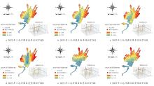
Fig. 10
Analysis of spring, summer and autumn forecast results of ICEEMDAN-ARIMA combined model in Santun river irrigation area, Xinjiang in 2023

| 1 |
|
| 2 |
|
| 3 |
|
| 4 |
|
| 5 |
郑思齐, 陈媛媛, 吴艳红, 等. 基于水域面积的鄱阳湖区干旱特征及气象-水文干旱传播过程研究[J]. 地球信息科学学报, 2025, 27(4): 1011-1023.
|
|
|
|
| 6 |
高晓瑜, 汤鹏程, 张莎, 等. 内蒙古各气候区主要作物生长季干旱特征及其与响应因子回归模型[J]. 干旱区研究, 2022, 39(5): 1410-1427.
|
|
|
|
| 7 |
谭佳宇, 梁妮, 周永强, 等. 新疆干旱区典型湖泊的碳排放监测与特征分析[J]. 湖泊科学, 2024, 36(6): 1834-1842.
|
|
|
|
| 8 |
梁晓萱. 西北地区综合干旱指数构建及干旱时空演变特征研究[D]. 杨凌: 西北农林科技大学, 2023.
|
|
|
|
| 9 |
|
| 10 |
刘涛, 司振江, 刘岩. 基于SPEI指数的松花江下游流域干旱时空特征分布[J]. 水利科学与寒区工程, 2024, 7(11): 35-39.
|
|
|
|
| 11 |
王东. 黄土高原干旱时空特征及对植被生长潜在风险评估[D]. 兰州: 兰州大学, 2023.
|
|
|
|
| 12 |
|
| 13 |
唐金利, 胡宝清, 余碧云, 等. 基于SPEI_PM分析广西干旱时空变化及其与ENSO的关系[J]. 中国农业气象, 2024, 45(9): 1067-1078.
|
|
|
|
| 14 |
刘轩, 周杰, 卢静, 等. 多源植被遥感产品应用于干旱监测的不确定性分析[J]. 遥感学报, 2024, 28(9): 2383-2404.
|
|
|
|
| 15 |
|
| 16 |
朱欣然, 黄长平, 吴波, 等. 顾及空间非平稳特征的遥感干旱监测[J]. 遥感学报, 2019, 23(3): 487-500.
|
|
|
|
| 17 |
|
| 18 |
王鹏新, 杜江莉, 张悦, 等. 基于遥感多参数和CNN-Transformer的冬小麦单产估测[J]. 农业机械学报, 2024, 55(3): 173-182.
|
|
|
|
| 19 |
周孝明, 张喆, 张越, 等. 基于TVDI的近20 a吐鲁番市干旱及影响因素分析[J]. 干旱区地理, 2024, 47(12): 2104-2114.
|
|
|
|
| 20 |
韦余鑫, 李巧, 卢春雷, 等. 基于ICEEMDAN分解的多维时间序列干旱预测模型性能评估[J]. 灌溉排水学报, 2025, 44(3): 94-103.
|
|
|
|
| 21 |
宋廷强, 鲁雪丽, 卢梦瑶, 等. 基于作物缺水指数的农业干旱监测模型构建[J]. 农业工程学报, 2021, 37(24): 65-72.
|
|
|
|
| 22 |
|
| 23 |
杨慧荣, 张玉虎, 崔恒建, 等. ARIMA和ANN模型的干旱预测适用性研究[J]. 干旱区地理, 2018, 41(5): 945-953.
|
|
|
|
| 24 |
|
| 25 |
|
| 26 |
|
| 27 |
丁严, 许德合, 曹连海, 等. 基于CEEMD的LSTM和ARIMA模型干旱预测适用性研究: 以新疆为例[J]. 干旱区研究, 2022, 39(3): 734-744.
|
|
|
|
| 28 |
|
| 29 |
|
| 30 |
|
| 31 |
张艳娇. 三屯河流域植被覆盖遥感监测及灌区土壤水分反演[D]. 乌鲁木齐: 新疆农业大学, 2023.
|
|
|
|
| 32 |
段俊伯. 温度植被干旱指数的改进及其在典型干旱区的应用[D]. 阜新: 辽宁工程技术大学, 2023.
|
|
|
|
| 33 |
|
| 34 |
|
| 35 |
翟涌光, 宁潇, 郝蕾. 联合Sentinel-1, 2, 3的河套灌区年内综合灌溉信息提取[J]. 测绘科学, 2022, 47(8): 204-212, 219.
|
|
|
|
| 36 |
程军, 李云祯, 邹渝. 新疆干旱时空动态及其对气候变化的响应[J]. 自然资源遥感, 2022, 34(4): 216-224.
|
|
|
|
| 37 |
李雯晴, 赵勇, 刘招, 等. 2001—2020年渭北黄土台塬区农业干旱变化特征及影响因素分析[J]. 水资源与水工程学报, 2024, 35(5): 1-10, 19.
|
|
|
|
| 38 |
雷庆文, 闫磊, 巫晨煜, 等. 基于MK-SVM和时序特征分析的月径流预报模型[J]. 水资源保护, 2024, 40(6): 148-154.
|
|
|
|
| 39 |
|
| 40 |
|
| 41 |
|
| 42 |
李俐, 许连香, 王鹏新, 等. 基于条件植被温度指数的夏玉米生长季干旱预测研究[J]. 农业机械学报, 2020, 51(1): 139-147.
|
|
|
|
| 43 |
|
| 44 |
|
| 45 |
黄静, 张运, 汪明秀, 等. 近17年新疆干旱时空分布特征及影响因素[J]. 生态学报, 2020, 40(3): 1077-1088.
|
|
|
| [1] | QUAN Jialu, CHEN Wenbai, WANG Yiqun, CHENG Jiajing, LIU Yilong. Research on Agricultural Drought Prediction Based on GCN-BiGRU-STMHSA [J]. Smart Agriculture, 2025, 7(1): 156-164. |
| [2] | HAN Dong, WANG Pengxin, ZHANG Yue, TIAN Huiren, ZHOU Xijia. Progress of Agricultural Drought Monitoring and Forecasting Using Satellite Remote Sensing [J]. Smart Agriculture, 2021, 3(2): 1-14. |
| Viewed | ||||||
|
Full text |
|
|||||
|
Abstract |
|
|||||


