Smart Agriculture ›› 2026, Vol. 8 ›› Issue (4): 164-179.doi: 10.12133/j.smartag.SA202512028
• Information Processing and Decision Making • Previous Articles
WANG Gaocheng1, LIU Jian1, LI Shasha1, ZHANG Tingting1, WANG Ailing1,2( )
)
Received:2025-12-30
Online:2026-07-30
Foundation items:Natural Science Foundation of Shandong Province(ZR2021MD018;ZR2025QC396)
About author:WANG Gaocheng, E-mail: Wanggc9804@163.com
corresponding author:
CLC Number:
WANG Gaocheng, LIU Jian, LI Shasha, ZHANG Tingting, WANG Ailing. Multi-Scenario Simulation of Land Use and Spatiotemporal Evolution of Carbon Storage in Plain Agricultural Region Based on The Coupled PLUS-InVEST Model[J]. Smart Agriculture, 2026, 8(4): 164-179.
Add to citation manager EndNote|Ris|BibTeX
URL: https://www.smartag.net.cn/EN/10.12133/j.smartag.SA202512028
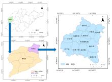
Fig. 1
The geographical location and administrative division of Gaotang county
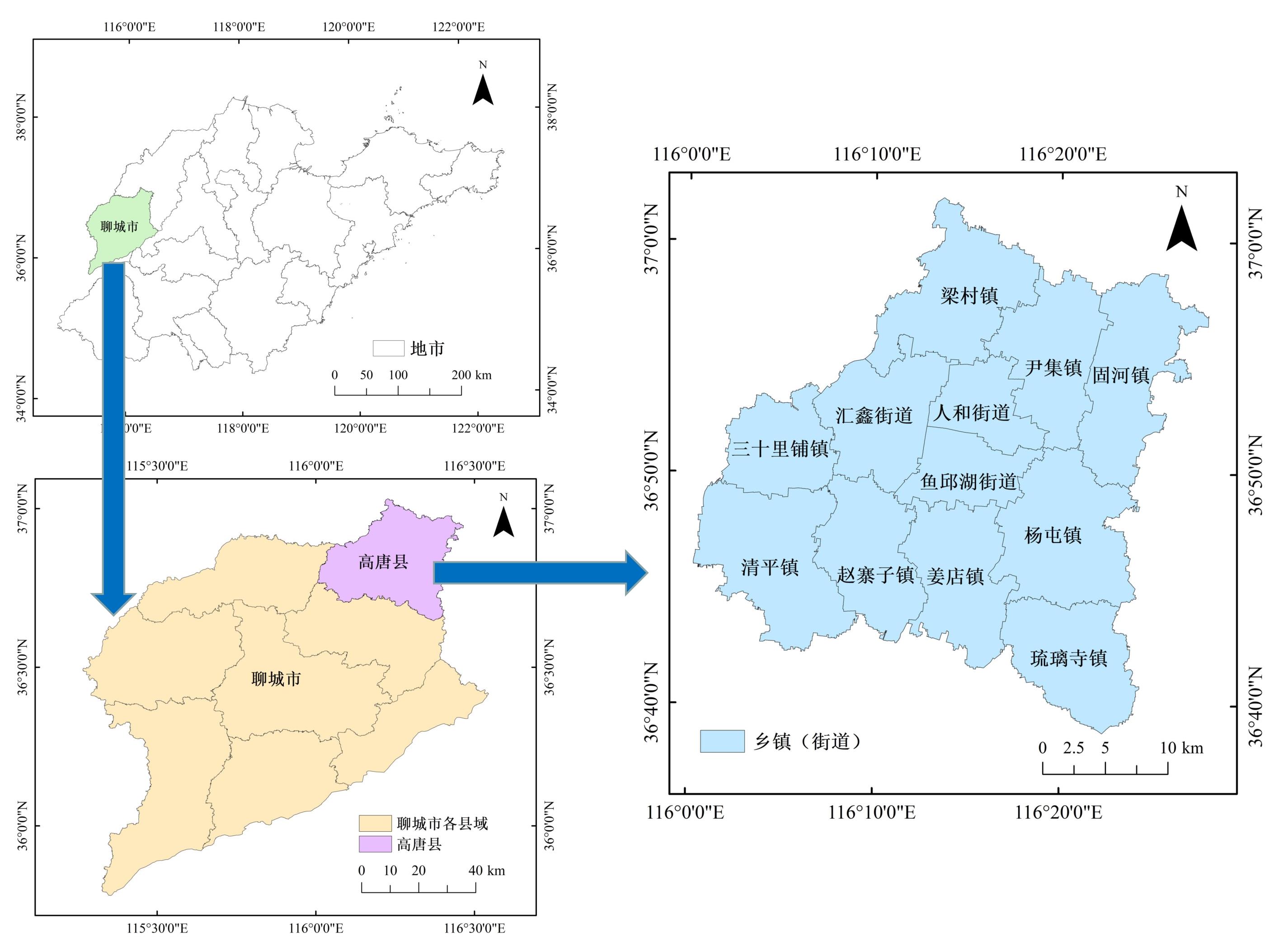
Table 1
Data and sources of land use simulation
| 数据类型 | 数据名称 | 数据来源 | 选取依据及作用 | 文献参考 |
|---|---|---|---|---|
| 遥感数据 | 土地利用数据 | 地理空间数据云(http://www.gscloud.cn) | Land系列影像覆盖广、可免费获取,是土地利用分类的常用数据,用于PLUS模型模拟和InVEST模型估算 | [ |
| 基础数据 | 行政区划 | 自然资源部地图技术审查中心标准地图服务系统(http://bzdt.ch.mnr.gov.cn/index.html) | 确定研究区范围和图件制作 | |
| 三区三线 | 《高唐县国土空间总体规划(2021—2035年)》 | 划定情景模拟中的限制转换区域 | ||
| 自然因素数据 | DEM | 地理空间数据云(http://www.gscloud.cn) | 对土地利用类型具有约束作用,用于PLUS模型驱动因子分析 | [ |
| 坡度、坡向 | 基于DEM数据在ArcGIS中计算 | |||
| NDVI | 资源环境科学数据平台(https://www.resdc.cn) | NDVI与植被量呈现显著正相关,能较直观地反映植被分布特征。用于PLUS模型驱动因子分析 | [ | |
| 土壤质地 | 高唐县农业农村局 | 能够揭示土壤颗粒属性的空间分布规律,在耕地气候调节与碳循环中起到关键作用,用于PLUS模型驱动因子分析 | [ | |
| 距河流距离 | 社会经济驱动因子和交通区位因子与耕地、建设用地等地类分布密切相关,社会经济发展水平较高、交通区位条件优越的地区,建设用地扩张明显。用于PLUS模型驱动因子分析 | [ | ||
| 社会经济数据 | 人均GDP 人口密度 | 高唐县统计年鉴 | [ | |
| 区位条件数据 | 距离指标 | 地理空间数据云(http://www.gscloud.cn) | [ |
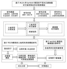
Fig.2
Research framework of land use and carbon storage in plain agricultural regions
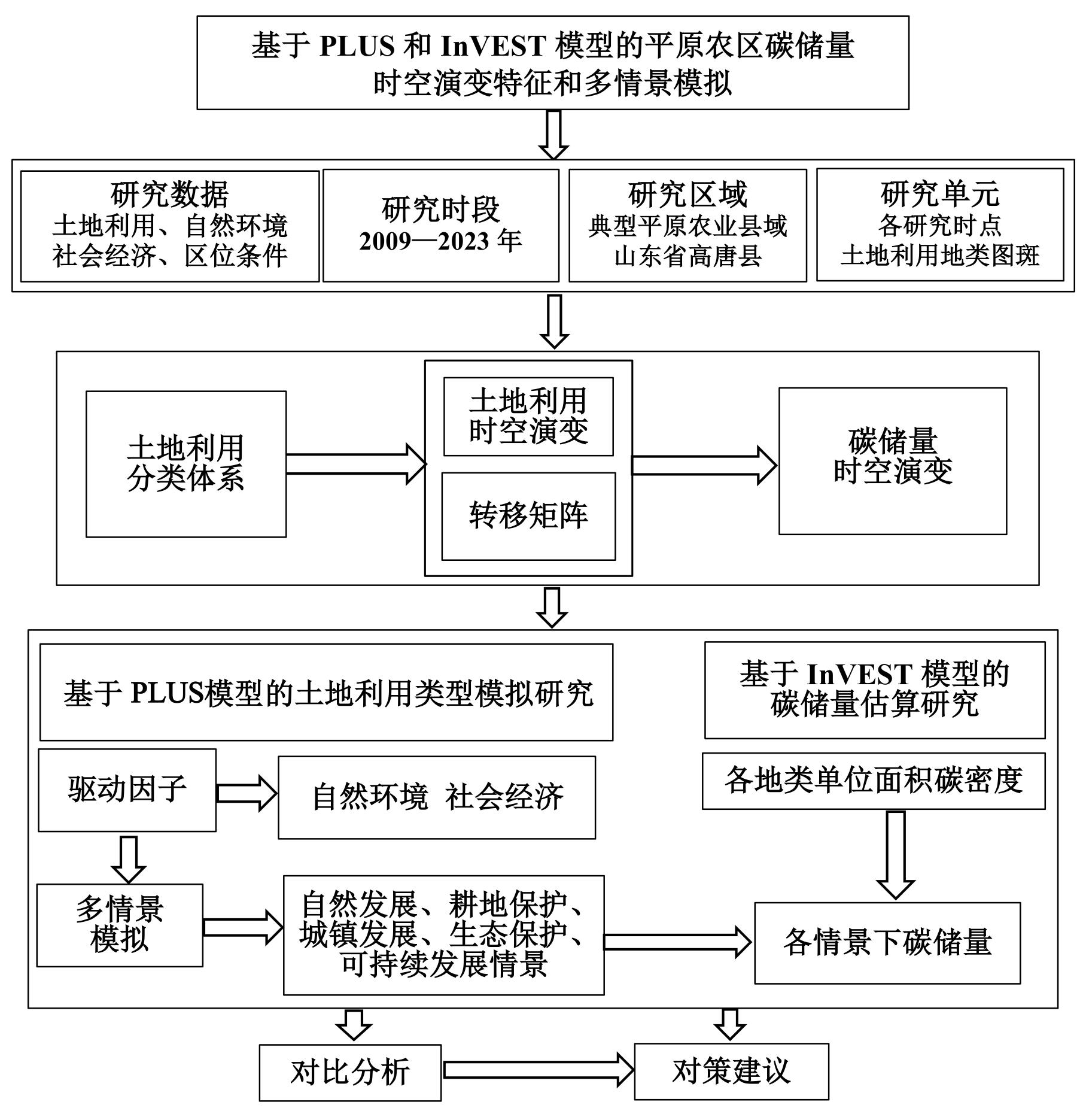
Table 2
Land use transfer cost matrix of various development scenarios in Gaotang county
| 自然发展情景 | 耕地保护情景 | 城镇发展情景 | ||||||||||||||||
|---|---|---|---|---|---|---|---|---|---|---|---|---|---|---|---|---|---|---|
| C | F | G | W | B | U | C | F | G | W | B | U | C | F | G | W | B | U | |
| C | 1 | 1 | 1 | 1 | 1 | 0 | 1 | 0 | 0 | 0 | 0 | 0 | 1 | 1 | 1 | 1 | 1 | 0 |
| F | 1 | 1 | 1 | 1 | 1 | 0 | 1 | 1 | 1 | 1 | 1 | 0 | 1 | 1 | 1 | 1 | 1 | 0 |
| G | 1 | 1 | 1 | 1 | 1 | 0 | 1 | 1 | 1 | 1 | 1 | 0 | 1 | 1 | 1 | 1 | 1 | 0 |
| W | 1 | 1 | 1 | 1 | 1 | 0 | 1 | 1 | 1 | 1 | 1 | 0 | 0 | 0 | 0 | 1 | 1 | 0 |
| B | 1 | 1 | 1 | 1 | 1 | 0 | 1 | 1 | 1 | 1 | 1 | 0 | 0 | 0 | 0 | 0 | 1 | 0 |
| U | 1 | 1 | 1 | 1 | 1 | 1 | 1 | 0 | 0 | 0 | 0 | 1 | 1 | 1 | 1 | 1 | 1 | 1 |
| 生态保护情景 | 可持续发展情景 | |||||||||||||||||
| C | F | G | W | B | U | C | F | G | W | B | U | |||||||
| C | 1 | 1 | 1 | 1 | 0 | 0 | 1 | 1 | 1 | 1 | 0 | 0 | ||||||
| F | 0 | 1 | 1 | 0 | 0 | 0 | 0 | 1 | 1 | 0 | 0 | 0 | ||||||
| G | 0 | 0 | 1 | 0 | 0 | 0 | 0 | 0 | 1 | 0 | 0 | 0 | ||||||
| W | 0 | 0 | 0 | 1 | 0 | 0 | 0 | 0 | 0 | 1 | 0 | 0 | ||||||
| B | 1 | 1 | 1 | 1 | 1 | 0 | 1 | 1 | 1 | 1 | 1 | 0 | ||||||
| U | 1 | 1 | 1 | 1 | 1 | 1 | 1 | 1 | 1 | 1 | 0 | 1 | ||||||
Table 3
The neighborhood weights of various land use types in Gaotang county in land use and carbon storage in plain agricultural regions
| 土地利用类型 | 耕地 | 林地 | 草地 | 水域 | 建设用地 | 未利用地 |
|---|---|---|---|---|---|---|
| 邻域权重 | 0.65 | 0.46 | 0.25 | 0.14 | 0.80 | 0.12 |
Table 4
Carbon density values of various land use types in Gaotang county in land use and carbon storage in plain agricultural regions
| 土地利用类型 | 地上生物碳密度/( | 地下生物碳密度/( | 土壤碳密度/( | 死亡碳密度/( |
|---|---|---|---|---|
| 耕地 | 2.42 | 0.46 | 90.58 | 0.24 |
| 林地 | 20.90 | 5.54 | 124.12 | 2.09 |
| 草地 | 0.92 | 4.82 | 97.21 | 0.09 |
| 水域 | 0.50 | 0.10 | 79.07 | 0.05 |
| 建设用地 | 0.00 | 0.00 | 71.18 | 0.00 |
| 未利用地 | 0.50 | 0.10 | 72.74 | 0.05 |
Fig.3
Spatial distribution patterns of land use in Gaotang county from 2009 to 2023
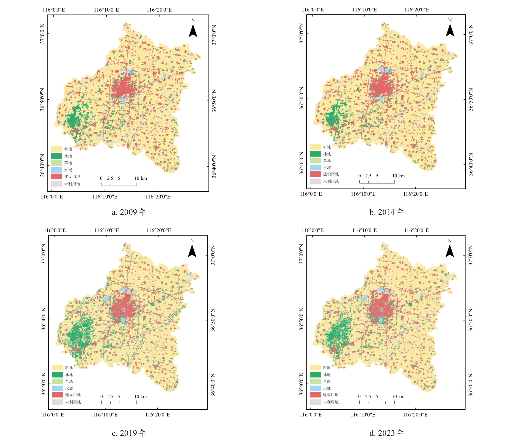
Table 5
Changes in land use types and their rates under different scenarios in Gaotang county from 2023 to 2035
| 土地利用类型 | 2023年 | 2035年 | |||||||
|---|---|---|---|---|---|---|---|---|---|
| 面积/ hm2 | 比例/ % | 自然发展情景 | 耕地保护情景 | ||||||
| 面积/ hm2 | 比例/ % | 变化率/ % | 面积/ hm2 | 比例/ % | 变化率/ % | ||||
| 耕地 | 63 861.50 | 67.410 | 68 879.78 | 72.710 0 | 7.86 | 69 116.78 | 72.960 0 | 8.23 | |
| 林地 | 8 714.40 | 9.200 | 6 244.52 | 6.590 0 | -28.34 | 6 189.14 | 6.530 0 | -28.98 | |
| 草地 | 431.92 | 0.460 | 392.07 | 0.410 0 | -9.23 | 397.24 | 0.420 0 | -8.03 | |
| 水域 | 6 595.52 | 6.960 | 5 497.65 | 5.800 0 | -16.65 | 5 480.68 | 5.790 0 | -16.90 | |
| 建设用地 | 15 133.89 | 15.970 | 13 723.92 | 14.490 0 | -9.32 | 13 553.89 | 14.300 0 | -10.44 | |
| 未利用地 | 0.86 | 0.001 | 0.15 | 0.000 2 | -82.56 | 0.36 | 0.000 4 | -58.14 | |
| 土地利用类型 | 2035年 | ||||||||
| 城镇发展情景 | 生态保护情景 | 可持续发展情景 | |||||||
| 面积 / hm2 | 比例/ % | 变化率/ % | 面积/ hm2 | 比例/ % | 变化率/ % | 面积/ hm2 | 比例/ % | 变化率/ % | |
| 耕地 | 67 459.24 | 71.210 0 | 5.63 | 67 835.20 | 71.600 0 | 6.22 | 68 132.04 | 71.920 0 | 6.69 |
| 林地 | 4 945.24 | 5.220 0 | -43.25 | 9 109.06 | 9.620 0 | 4.53 | 9 056.11 | 9.560 0 | 3.92 |
| 草地 | 309.23 | 0.330 0 | -28.41 | 439.87 | 0.460 0 | 1.84 | 438.36 | 0.460 0 | 1.49 |
| 水域 | 6 058.25 | 6.390 0 | -8.15 | 6 098.25 | 6.440 0 | -7.54 | 6 064.65 | 6.400 0 | -8.05 |
| 建设用地 | 15 965.89 | 16.850 0 | 5.50 | 11 255.62 | 11.880 0 | -25.63 | 11 046.84 | 11.660 0 | -27.01 |
| 未利用地 | 0.24 | 0.000 3 | -72.09 | 0.09 | 0.000 1 | -89.53 | 0.09 | 0.000 1 | -89.53 |
Fig.4
Spatial patterns of land use in Gaotang county under different scenarios in 2035
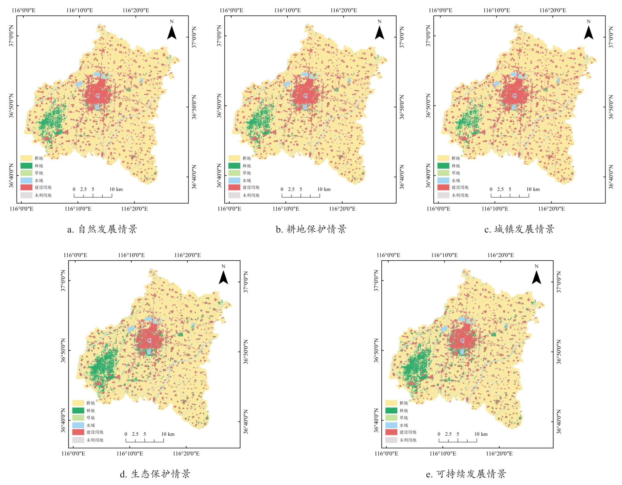
Table 6
Changes in carbon storage in Gaotang county from 2009 to 2023
| 土地利用类型 | 2009年 | 2014年 | 2019年 | 2023年 |
|---|---|---|---|---|
| 耕地 | 628.79 | 629.62 | 578.91 | 598.76 |
| 林地 | 92.47 | 84.02 | 171.26 | 133.86 |
| 草地 | 4.23 | 3.62 | 4.34 | 4.41 |
| 水域 | 43.16 | 43.57 | 52.75 | 52.66 |
| 建设用地 | 115.30 | 118.45 | 104.81 | 107.20 |
| 未利用地 | 1.51 | 1.41 | 0.01 | 0.01 |
| 总计 | 885.46 | 880.69 | 912.08 | 896.90 |
Fig.5
Distribution of carbon storage in Gaotang county from 2009 to 2023
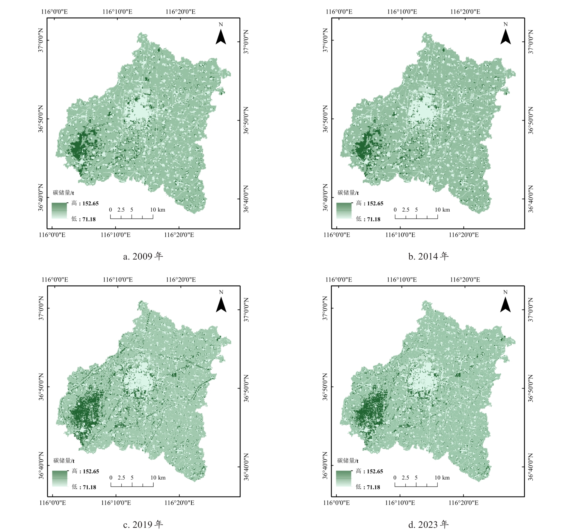
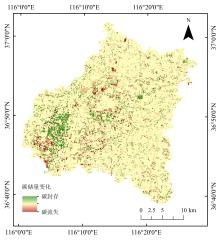
Fig.6
Carbon storage changes in Gaotang county from 2009 to 2023
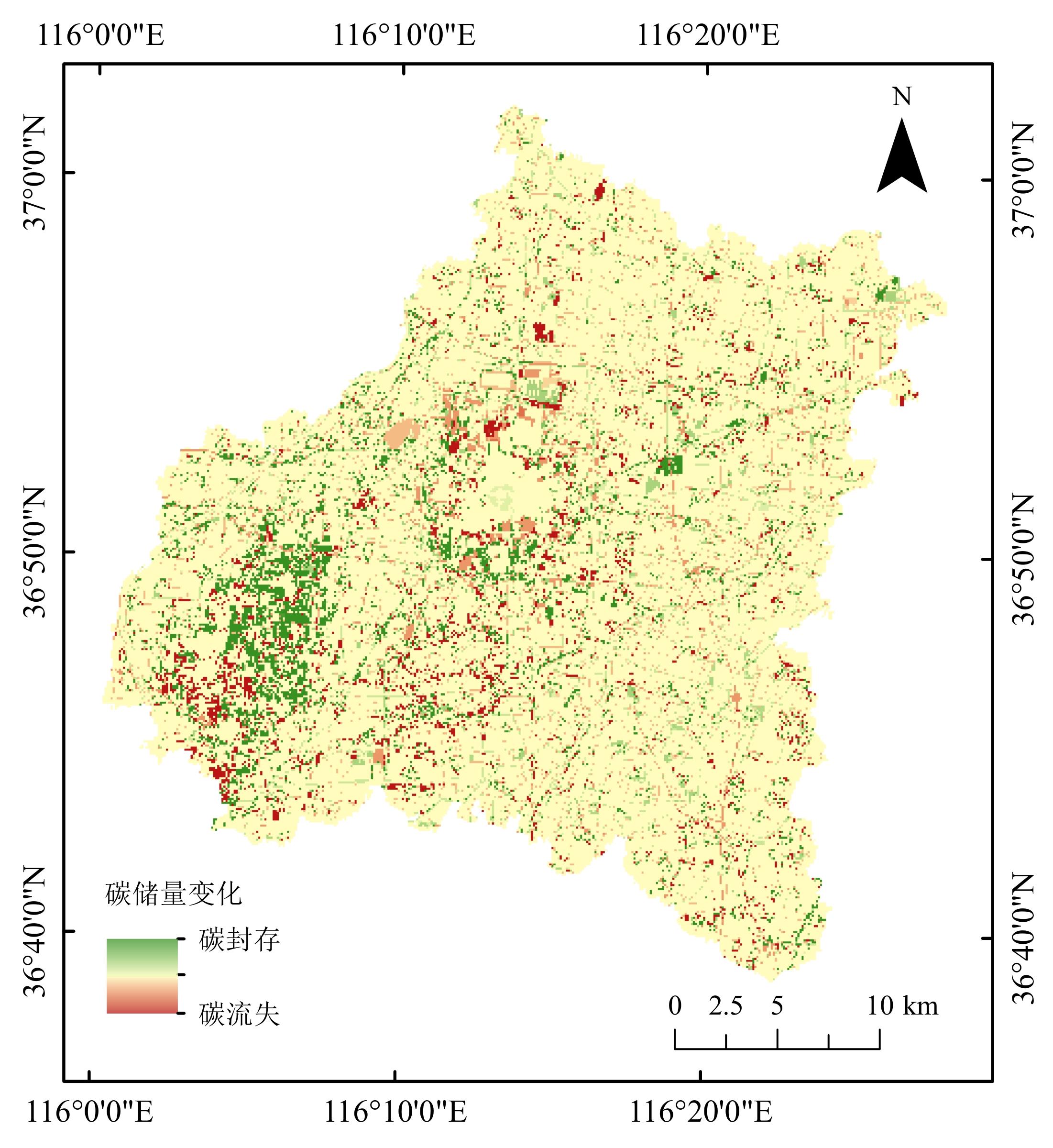
Table 7
Carbon storage of various land types in Gaotang county under different scenarios in 2035
| 土地利用类型 | 自然发展情景 | 耕地保护情景 | 城镇发展情景 | 生态保护情景 | 可持续发展情景 |
|---|---|---|---|---|---|
| 耕地 | 642.650 | 645.360 | 633.750 | 630.160 | 634.520 |
| 林地 | 80.540 | 79.240 | 63.280 | 134.860 | 134.060 |
| 草地 | 4.040 | 4.160 | 3.320 | 4.780 | 4.660 |
| 水域 | 46.810 | 46.290 | 51.240 | 50.010 | 49.030 |
| 建设用地 | 103.090 | 101.520 | 115.220 | 84.250 | 82.160 |
| 未利用地 | 0.001 | 0.003 | 0.002 | 0.001 | 0.001 |
| 总计 | 877.130 | 876.580 | 866.800 | 904.060 | 904.430 |
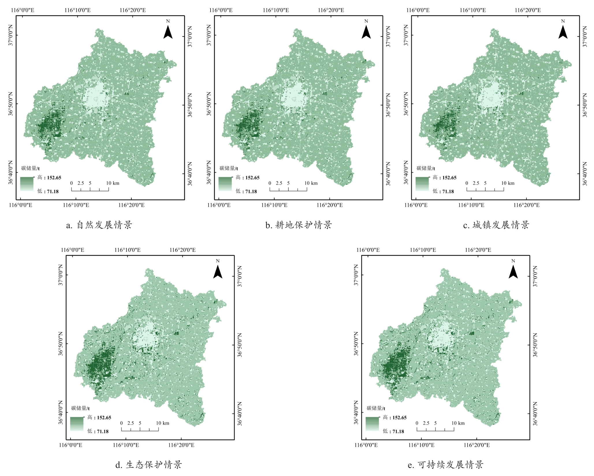
Fig.7
Distribution of carbon storage in Gaotang county under different scenarios in 2035
| [1] |
周曙东, 雷会妨, 葛继红, 等. “双碳”背景下中国能源结构转型的碳减排潜力及宏观经济影响[J]. 中国人口·资源与环境, 2024, 34(12): 55-63.
|
|
|
|
| [2] |
刘耀彬, 邓伟凤, 李硕硕, 等. 基于碳汇潜力的碳排放空间关联网络结构特征及影响因素——以长江中游城市群为例[J]. 中国人口·资源与环境, 2024, 34(3): 1-15.
|
|
|
|
| [3] |
|
| [4] |
彭建, 杜悦悦, 刘焱序, 等. 从自然区划、土地变化到景观服务: 发展中的中国综合自然地理学[J]. 地理研究, 2017, 36(10): 1819-1833.
|
|
|
|
| [5] |
邓丽明, 杨骥, 尹小玲, 等. 粤港澳大湾区生态系统服务供需关系及其对城市化多空间尺度的响应[J]. 生态学报, 2024, 44(20): 9094-9107.
|
|
|
|
| [6] |
于晓燕, 商亚男, 魏光普, 等. 基于PLUS-InVEST模型的国家级稀土矿区土地利用变化与碳储量预测研究[J]. 沈阳农业大学学报, 2025, 56 (6): 153-164.
|
|
|
|
| [7] |
李志英, 薛梦柯, 王绍邦, 等. 基于PSR-PLUS模型的昆明市土地生态安全预警研究[J]. 长江流域资源与环境, 2025, 34(4): 871-881.
|
|
|
|
| [8] |
刘康, 张寒, 张道军, 等. 黄土高原生态系统碳储量情景模拟与驱动因素——基于PLUS-InVEST-Geodector模型的研究[J]. 中国环境科学, 2025, 45(4): 2159-2170.
|
|
|
|
| [9] |
王瑞利, 张存厚, 王明玖. 基于DNDC模型的赛罕乌拉自然保护区草地生态系统碳动态[J]. 中国草地学报, 2019, 41(4): 167-172.
|
|
|
|
| [10] |
王建步, 张杰, 马毅, 等. 基于GF-1 WFV的黄河口湿地植被碳储量估算研究[J]. 海洋科学进展, 2019, 37(1): 604.
|
|
|
|
| [11] |
李尉尉, 薛志泳, 朱建华, 等. 基于GEE平台多源遥感数据的海南岛红树林碳储量估算[J]. 自然资源遥感, 2025, 37(2): 220-227.
|
|
|
|
| [12] |
闫昊婷, 乔伟峰, 李语旻, 等. 基于生态安全格局的县域生态保护红线优化研究——以常州市金坛区为例[J]. 地理研究, 2024, 43(8): 2141-2157.
|
|
|
|
| [13] |
刘洋, 张军, 周冬梅, 等. 基于InVEST模型的疏勒河流域碳储量时空变化研究[J]. 生态学报, 2021, 41(10): 4052-4065.
|
|
|
|
| [14] |
张燕, 师学义, 唐倩. 不同土地利用情景下汾河上游地区碳储量评估[J]. 生态学报, 2021, 41(1): 360-373.
|
|
|
|
| [15] |
王伟武, 伏添乐, 陈欢. 基于PLUS-InVEST模型的长三角城市群碳储量时空演变与预测[J]. 环境科学, 2025, 46(4): 1937-1950.
|
|
|
|
| [16] |
张雄, 毛星月, 柯珂, 等. 区域土地用途转换的土地资源碳储量研究[J]. 中国人口·资源与环境, 2023, 33(8): 193-202.
|
|
|
|
| [17] |
张平平, 李艳红, 殷浩然, 等. 中国南北过渡带生态系统碳储量时空变化及动态模拟[J]. 自然资源学报, 2022, 37(5): 1183-1197.
|
|
|
|
| [18] |
|
| [19] |
苏浩东, 任彦芳, 马元旭, 等. 新疆10 m分辨率土地利用/土地覆盖类型数据集(2015、2020年)[J]. 中国科学数据, 2025, 10(3): 168-184.
|
|
|
|
| [20] |
朱文博, 张静静, 崔耀平, 等. 基于土地利用变化情景的生态系统碳储量评估——以太行山淇河流域为例[J]. 地理学报, 2019, 74(3): 446-459.
|
|
|
|
| [21] |
陈文娇, 翁永玲, 路云阁. 基于多级决策树分类的土地利用与覆盖信息提取[J]. 测绘与空间地理信息, 2017, 40(9): 63-68, 73.
|
|
|
|
| [22] |
信志红, 王宁, 李峰, 等. 基于Landsat的黄河口地区土地利用类型研究[J]. 中国农业资源与区划, 2018, 39(1): 99-105.
|
|
|
|
| [23] |
肖建英, 戴津津, 方昕然, 等. 基于PLUS模型的徐州市生态系统服务价值多情景模拟研究[J]. 中国土地科学, 2024, 38(4): 125-134.
|
|
|
|
| [24] |
雷馨, 海新权. 耦合PLUS-InVEST模型的兰州市土地利用变化及碳储量经济价值估算[J]. 地理科学, 2025, 45(2): 339-348.
|
|
|
|
| [25] |
张启扬, 刘仁志, 栾朝旭. 基于PLUS模型的典型农牧交错带土地利用驱动力分析与多情景模拟[J]. 水土保持研究, 2025, 32(1): 368-378.
|
|
|
|
| [26] |
|
| [27] |
|
| [28] |
|
| [29] |
|
| [30] |
周满意, 王承武. 基于PLUS模型的乌鲁木齐市"三生"空间多情景模拟[J]. 中国环境科学, 2024, 44(7): 4021-4030.
|
|
|
|
| [31] |
|
| [32] |
|
| [33] |
|
| [34] |
姚侠妹, 盛雨恬, 祁慧敏, 等. 模拟多情景下淮河生态经济带土地利用变化及生态系统服务价值的空间响应[J]. 水土保持研究, 2025, 32(3): 300-311.
|
|
|
|
| [35] |
裴志方, 吴彬, 范玉龙. 丹江口库区土地利用多情景模拟及其生态环境效应[J]. 长江流域资源与环境, 2025, 34(10): 2264-2273.
|
|
|
|
| [36] |
张爽, 高启晨, 张戎, 等. 基于PLUS-InVEST模型碳储量时空演变及驱动因素分析——以纳帕海流域为例[J]. 中国环境科学, 2024, 44(9): 5192-5201.
|
|
|
|
| [37] |
张龙江, 陈国平, 林伊琳, 等. 基于MOP-PLUS-InVEST模型的碳储量多情景模拟及驱动机制分析[J]. 农业工程学报, 2024, 40(22): 223-233,
|
|
|
|
| [38] |
朱志强, 马晓双, 胡洪. 基于耦合FLUS-InVEST模型的广州市生态系统碳储量时空演变与预测[J]. 水土保持通报, 2021, 41(2): 222-229, 239.
|
|
|
|
| [39] |
范强, 孙虎虎, 孙爽, 等. 生态-耕地保护下的山东省碳储量估算与演变[J]. 生态学报, 2025, 45(4): 1588-1598.
|
|
|
| [1] | LIU Miao, ZHANG Jiayi, LI Zhenhai, CHEN Jing. Analysis of the Spatiotemporal Evolution and Driving Forces of Rural Settlements in Relation to Terrain Differences [J]. Smart Agriculture, 2025, 7(6): 210-224. |
| [2] | DONG Guanglong, YIN Haiyang, YAO Rongyan, YUAN Chenzhao, QU Chengchuang, TIAN Yuan, JIA Min. Spatiotemporal Pattern and Multi-Scenario Simulation of Land Use Conflicts: A Case Study of Shandong Section of the Yellow River Basin [J]. Smart Agriculture, 2025, 7(2): 183-195. |
| Viewed | ||||||
|
Full text |
|
|||||
|
Abstract |
|
|||||