| [1] |
朱逸青, 吴尚蓉, 王迪. 土壤水分雷达遥感反演研究[J]. 中国农业信息, 2024, 36(3): 45-62.
|
|
ZHU Y Q, WU S R, WANG D. Soil moisture retrieval by radar remote sensing[J]. China agricultural informatics, 2024, 36(3): 45-62.
|
| [2] |
吴尚蓉, 赵荣坤, 曹红, 等. 基于微波散射机理的SAR作物和土壤参数反演研究进展[J]. 雷达学报(中英文), 2025, 14(3): 735-753.
|
|
WU S R, ZHAO R K, CAO H, et al. Research progress on SAR inversion of crop and soil parameters based on microwave scattering theory[J]. Journal of radars, 2025, 14(3): 735-753.
|
| [3] |
齐江涛, 程盼婷, 高芳芳, 等. 农田土壤理化参数快速获取技术研究进展与展望[J]. 智慧农业(中英文), 2024, 6(3): 17-33.
|
|
QI J T, CHENG P T, GAO F F, et al. Research advances and prospects on rapid acquisition technology of farmland soil physical and chemical parameters[J]. Smart agriculture, 2024, 6(3): 17-33.
|
| [4] |
时洪涛. 时序极化SAR土壤湿度及农作物生物物理参数估计方法研究[D]. 武汉: 武汉大学, 2021.
|
|
SHI H T. Soil moisture and crop biophysical parameters estimation from time series of PolSAR imageries[D]. Wuhan: Wuhan University, 2021.
|
| [5] |
KONINGS A G, RAO K, STEELE-DUNNE S C. Macro to micro: Microwave remote sensing of plant water content for physiology and ecology[J]. New phytologist, 2019, 223(3): 1166-1172.
|
| [6] |
中华人民共和国水利部. 中国水旱灾害防御公报-2024[M]. 北京: 中国水利水电出版社, 2025.
|
| [7] |
PENG J, LOEW A. Recent advances in soil moisture estimation from remote sensing[J]. Water, 2017, 9(7): ID 530.
|
| [8] |
马志红, 方文松, 刘学义. 不同土壤类型及测定距离下人工与自动站土壤湿度差异分析[J]. 气象与环境科学, 2016, 39(4): 43-48.
|
|
MA Z H, FANG W S, LIU X Y. Variation analysis between manual and automatic soil moisture observation under different soil types and measure distance[J]. Meteorological and environmental sciences, 2016, 39(4): 43-48.
|
| [9] |
李杏朝. 微波遥感监测土壤水分的研究初探[J]. 遥感技术与应用, 1995, 10(4): 1-8.
|
|
LI X C. A study on soil moisture monitoring by using microwave remote sensing[J]. Remote sensing technology and application, 1995, 10(4): 1-8.
|
| [10] |
艾璐, 孙淑怡, 李书光, 等. 光学与SAR遥感协同反演土壤水分研究进展[J]. 自然资源遥感, 2021, 33(4): 10-18.
|
|
AI L, SUN S Y, LI S G, et al. Research progress on the cooperative inversion of soil moisture using optical and SAR remote sensing[J]. Remote sensing for natural resources, 2021, 33(4): 10-18.
|
| [11] |
张王菲, 陈尔学, 李增元, 等. 雷达遥感农业应用综述[J]. 雷达学报, 2020, 9(3): 444-461.
|
|
ZHANG W F, CHEN E X, LI Z Y, et al. Review of applications of radar remote sensing in agriculture[J]. Journal of radars, 2020, 9(3): 444-461.
|
| [12] |
朱建军, 付海强, 汪长城. 极化干涉SAR地表覆盖层“穿透测绘”技术进展[J]. 测绘学报, 2022, 51(6): 983-995.
|
|
ZHU J J, FU H Q, WANG C C. Research progress of "penetration mapping" of earth surface by PolInSAR[J]. Acta geodaetica et cartographica sinica, 2022, 51(6): 983-995.
|
| [13] |
MKHWENKWANA A, MATONGERA T N, BLAAUW C, et al. A critical review on the applications of Sentinel satellite datasets for soil moisture assessment in crop production[J]. International journal of applied earth observation and geoinformation, 2025, 141: ID 104647.
|
| [14] |
DOU Q, XIE Q H, PENG X, et al. Soil moisture retrieval over crop fields based on two-component polarimetric decomposition: A comparison of generalized volume scattering models[J]. Journal of hydrology, 2022, 615: ID 128696.
|
| [15] |
FAN D, ZHAO T J, JIANG X G, et al. A Sentinel-1 SAR-based global 1-km resolution soil moisture data product: Algorithm and preliminary assessment[J]. Remote sensing of environment, 2025, 318: ID 114579.
|
| [16] |
WANG G Y, LI Z W, HU J, et al. A modified EVD-based phase linking method in decorrelated scenario with time series polarimetric scattering consistency[J]. IEEE journal of selected topics in applied earth observations and remote sensing, 2025, 18: 7694-7706.
|
| [17] |
WANG G Y, LI Z W, GAO H, et al. Adaptive sequential estimator for InSAR time series phase estimation[J]. International journal of applied earth observation and geoinformation, 2025, 139: ID 104552.
|
| [18] |
QIAN J X, YANG J, SUN W D, et al. Evaluation and improvement of spatiotemporal estimation and transferability of multi-layer and profile soil moisture in the Qinghai Lake and Heihe River basins using multi-strategy constraints[J]. Geoderma, 2025, 455: ID 117222.
|
| [19] |
邵芸, 李坤. 农业雷达遥感方法与应用[M]. 北京: 科学出版社, 2023.
|
| [20] |
DONG Z, GAO M F, KARNIELI A. Soil moisture retrieval in the Northeast China Plain's agricultural fields using single-temporal L-band SAR and the coupled MWCM-oh model[J]. Remote sensing, 2025, 17(3): ID 478.
|
| [21] |
FENG S J, QIU J X, CROW W T, et al. Improved estimation of vegetation water content and its impact on L-band soil moisture retrieva l over cropland[J]. Journal of hydrology, 2023, 617: ID 129015.
|
| [22] |
HAN D, LIU S B, DU Y, et al. Crop water content of winter wheat revealed with Sentinel-1 and Sentinel-2 imagery[J]. Sensors, 2019, 19(18): ID 4013.
|
| [23] |
SHI J H, YANG H, HOU X L, et al. Coupling SAR and optical remote sensing data for soil moisture retrieval over dense vegetation covered areas[J]. PLoS one, 2025, 20(1): ID e0315971.
|
| [24] |
孙亚勇. 基于C和L波段主被动微波遥感的土壤水分协同反演研究[D]. 北京: 中国水利水电科学研究院, 2018.
|
|
SUN Y Y. Synergetic inversion of surface soil moisture based on C/L band active and passive microwave remote sensing[D]. Beijing: China Institute of Water Resources and Hydropower Research, 2018.
|
| [25] |
吴星辉, 马海涛, 张杰. 地基合成孔径雷达的发展现状及应用[J]. 武汉大学学报(信息科学版), 2019, 44(7): 1073-1081.
|
|
WU X H, MA H T, ZHANG J. Development status and application of ground-based synthetic aperture radar[J]. Geomatics and information science of Wuhan university, 2019, 44(7): 1073-1081.
|
| [26] |
程玉鑫, 袁凌峰. 机载SAR发展现状[J]. 电子测试, 2016(8): 19, 6.
|
|
CHENG Y X, YUAN L F. Current situation of the development of space-borne SAR[J]. Electronic test, 2016(8): 19, 6.
|
| [27] |
朱金彪, 丁赤飚, 潘洁, 等. 高分航空载荷在新舟60飞行平台上的集成研究[C]// 第四届高分辨率对地观测学术年会论文集. 武汉, 中国: 高分辨率对地观测系统重大专项管理办公室, 2017: 297-304.
|
| [28] |
张庆君, 韩晓磊, 刘杰. 星载合成孔径雷达遥感技术进展及发展趋势[J]. 航天器工程, 2017, 26(6): 1-8.
|
|
ZHANG Q J, HAN X L, LIU J. Technology progress and development trend of spaceborne synthetic aperture radar remote sensing[J]. Spacecraft engineering, 2017, 26(6): 1-8.
|
| [29] |
FUEGEN T, SPERLICH E, HEER C, et al. Development status of the biomass SAR instrument[C]// EUSAR 2021, 13th European Conference on Synthetic Aperture Radar. Berlin, Germany: VDE, 2021: 1-6.
|
| [30] |
邓云凯, 王宇, 刘开雨, 等. 陆探一号卫星SAR载荷关键技术[J]. 测绘学报, 2024, 53(10): 1881-1895.
|
|
DENG Y K, WANG Y, LIU K Y, et al. Key technologies for spaceborne SAR payload of LuTan-1 satellite system[J]. Acta geodaetica et cartographica sinica, 2024, 53(10): 1881-1895.
|
| [31] |
SOUYRIS J C, IMBO P, FJORTOFT R, et al. Compact polarimetry based on symmetry properties of geophysical media: The/spl Pi// 4 mode[J]. IEEE transactions on geoscience and remote sensing, 2005, 43(3): 634-646.
|
| [32] |
RANEY R K. Hybrid-polarity SAR architecture[J]. IEEE transactions on geoscience and remote sensing, 2007, 45(11): 3397-3404.
|
| [33] |
赵含, 张王菲, 姬永杰, 等. 简缩极化SAR数据支持的森林地上生物量反演[J]. 遥感学报, 2024, 28(9): 2416-2426.
|
|
ZHAO H, ZHANG W F, JI Y J, et al. Retrieval of forest aboveground biomass via compact polarimetric SAR data[J]. National remote sensing bulletin, 2024, 28(9): 2416-2426.
|
| [34] |
高晗. 顾及时变特性的时序极化SAR对象级农作物分类研究[D]. 长沙: 中南大学, 2022.
|
|
GAO H. Object-level crop classification based on the time-varying characteristics with time-series polarimetric SAR data[D]. Changsha: Central South University, 2022.
|
| [35] |
POTIN P, ROSICH B, MIRANDA N, et al. Copernicus sentinel-1 constellation mission operations status[C]// IGARSS 2019 - 2019 IEEE International Geoscience and Remote Sensing Symposium. Piscataway, New Jersey, USA: IEEE, 2019: 5385-5388.
|
| [36] |
SUN C L, ZHANG H, XU L, et al. Rice yield prediction using radar vegetation indices from Sentinel-1 data and multiscale one-dimensional convolutional long- and short-term memory network model[J]. Journal of applied remote sensing, 2024, 18(2): ID 024505.
|
| [37] |
D'URSO G, MINACAPILLI M. A semi-empirical approach for surface soil water content estimation from radar data without a-priori information on surface roughness[J]. Journal of hydrology, 2006, 321(1/2/3/4): 297-310.
|
| [38] |
SHI H, LOPEZ-SANCHEZ J M, YANG J, et al. Contribution of polarimetry and multi-incidence to soil moisture estimation over agricultural fields based on time series of L-band SAR data[J]. IEEE journal of selected topics in applied earth observations and remote sensing, 2021, 14: 300-313.
|
| [39] |
KIM S B, MOGHADDAM M, TSANG L, et al. Models of L-band radar backscattering coefficients over global terrain for soil moisture retrieval[J]. IEEE transactions on geoscience and remote sensing, 2014, 52(2): 1381-1396.
|
| [40] |
GAO H, WANG C C, ZHU J J, et al. TVPol-edge: An edge detection method with time-varying polarimetric characteristics for crop field edge delineation[J]. IEEE transactions on geoscience and remote sensing, 2024, 62: ID 4408917.
|
| [41] |
GAO H, WANG C C, XIANG D L, et al. TSPol-ASLIC: Adaptive superpixel generation with local iterative clustering for time-series quad-and dual-polarization SAR data[J]. IEEE transactions on geoscience and remote sensing, 2022, 60: ID 5217015.
|
| [42] |
BALENZANO A, MATTIA F, SATALINO G, et al. Dense temporal series of C- and L-band SAR data for soil moisture retrieval over agricultural crops[J]. IEEE journal of selected topics in applied earth observations and remote sensing, 2011, 4(2): 439-450.
|
| [43] |
WANG H Q, MAGAGI R, GOITA K. Polarimetric decomposition of C-band SAR data for soil moisture retrieval over agricultural fields[C]// 2016 IEEE International Geoscience and Remote Sensing Symposium (IGARSS). Piscataway, New Jersey, USA: IEEE, 2016: 1687-1690.
|
| [44] |
ZHANG L, LV X, CHEN Q, et.al. Estimation of surface soil moisture during corn growth stage from SAR and optical data using a combined scattering model[J]. Remote sensing, 2020, 12(11): ID 1844.
|
| [45] |
BALENZANO A, SATALINO G, LOVERGINE F, et al. On the use of temporal series of L-and X-band SAR data for soil moisture retrieval. Capitanata plain case study[J]. European journal of remote sensing, 2013, 46(1): 721-737.
|
| [46] |
BINDLISH R, BARROS A P. Multifrequency soil moisture inversion from SAR measurements with the use of IEM[J]. Remote sensing of environment, 2000, 71(1): 67-88.
|
| [47] |
JOSEPH A T, VAN DER VELDE R, O'NEILL P E, et al. Soil moisture retrieval during a corn growth cycle using L-band (1.6 GHz) radar observations[J]. IEEE transactions on geoscience and remote sensing, 2008, 46(8): 2365-2374.
|
| [48] |
KIM S, LIAO T. Towards global retrieval of field-scale surface soil moisture using L-band sar data[C]// IGARSS 2022 - 2022 IEEE International Geoscience and Remote Sensing Symposium. Piscataway, New Jersey, USA: IEEE, 2022: 5452-5455.
|
| [49] |
LI J H, WANG S S. Using SAR-derived vegetation descriptors in a water cloud model to improve soil moisture retrieval[J]. Remote sensing, 2018, 10(9): ID 1370.
|
| [50] |
BAGHDADI N, HAJJ MEL, ZRIBI M. Coupling SAR C-band and optical data for soil moisture and leaf area index retrieval over irrigated grasslands[C]// 2016 IEEE International Geoscience and Remote Sensing Symposium (IGARSS). Piscataway, New Jersey, USA: IEEE, 2016: 3551-3554.
|
| [51] |
HAJJ MEL, BAGHDADI N, ZRIBI M, et al. Soil moisture retrieval over irrigated grassland using X-band SAR data[J]. Remote sensing of environment, 2016, 176: 202-218.
|
| [52] |
HAJJ MEL, BAGHDADI N, ZRIBI M, et al. Soil moisture retrieval over irrigated grasslands using X-band SAR data combined with optical data acquired at high resolution[C]// 2015 IEEE International Geoscience and Remote Sensing Symposium (IGARSS). Piscataway, New Jersey, USA: IEEE, 2015: 1328-1331.
|
| [53] |
何磊. 小麦微波散射机理与生物量参数反演研究[D]. 成都: 电子科技大学, 2016.
|
|
HE L. Research on microvave scattering mechanism and inversion of biomass of wheat[D]. Chengdu: University of Electronic Science and Technology of China, 2016.
|
| [54] |
蒋婷. 基于多时相Radarsat-2的冬小麦覆盖地表土壤湿度反演研究[D]. 南充: 西华师范大学, 2018.
|
|
JIANG T. Research on soil moisture retrieval covered by winter wheat based on multi-temporal radarsat-2 images[D]. Nanchong: China West Normal University, 2018.
|
| [55] |
SRIVASTAVA H S, SIVASANKAR T, GAVALI M D, et al. Soil moisture estimation underneath crop cover using high incidence angle C-band Sentinel-1 SAR data[J]. Kuwait journal of science, 2024, 51(1): ID 100101.
|
| [56] |
BAGHDADI N, HOLAH N, ZRIBI M. Soil moisture estimation using multi-incidence and multi-polarization ASAR data[J]. International journal of remote sensing, 2006, 27(10): 1907-1920.
|
| [57] |
SRIVASTAVA H S, PATEL P, SHARMA Y, et al. Large-area soil moisture estimation using multi-incidence-angle RADARSAT-1 SAR data[J]. IEEE transactions on geoscience and remote sensing, 2009, 47(8): 2528-2535.
|
| [58] |
WANG H Q, MAGAGI R, GOITA K. Polarimetric decomposition of multi-angular SAR data for soil moisture retrieval over agricultural fields[C]// 2017 IEEE International Geoscience and Remote Sensing Symposium (IGARSS). Piscataway, New Jersey, USA: IEEE, 2017: 4947-4950.
|
| [59] |
XUE W X, XIE Q H, PENG X, et al. Soil moisture retrieval in winter wheat fields at different growth stages: Integrating a two-component polarimetric SAR decomposition with CIEM[J]. IEEE journal of selected topics in applied earth observations and remote sensing, 2025, 18: 20315-20332.
|
| [60] |
雷志斌, 孟庆岩, 田淑芳, 等. 基于GF-3和Landsat8遥感数据的土壤水分反演研究[J]. 地球信息科学学报, 2019, 21(12): 1965-1976.
|
|
LEI Z B, MENG Q Y, TIAN S F, et al. Soil moisture retrieval study based on GF-3 and Landsat8 remote sensing data[J]. Journal of geo-information science, 2019, 21(12): 1965-1976.
|
| [61] |
刘钇廷. 基于哨兵1/2的冬小麦田间地表土壤水分反演方法研究[D]. 阿拉尔: 塔里木大学, 2022.
|
|
LIU Y T. Retrieval of surface soil moisture in winter wheat field based on Sentinel-1/2 data[D]. Ala'er: Tarim University, 2022.
|
| [62] |
周鹏, 丁建丽, 高婷婷. C波段多极化SAR反演土壤水分研究[J]. 新疆农业科学, 2010, 47(7): 1416-1420.
|
|
ZHOU P, DING J L, GAO T T. A study on soil moisture retrieval by C-band multi-polarization SAR[J]. Xinjiang agricultural sciences, 2010, 47(7): 1416-1420.
|
| [63] |
胡蝶, 郭铌, 沙莎, 等. Radarsat-2/SAR和MODIS数据联合反演黄土高原地区植被覆盖下土壤水分研究[J]. 遥感技术与应用, 2015, 30(5): 860-867.
|
|
HU D, GUO N, SHA S, et al. Soil moisture retrieved using radarsat-2/SAR and MODIS remote sensing data in vegetated areas of Loess Plateau[J]. Remote sensing technology and application, 2015, 30(5): 860-867.
|
| [64] |
OH Y, SARABANDI K, ULABY F T. An empirical model and an inversion technique for radar scattering from bare soil surfaces[J]. IEEE transactions on geoscience and remote sensing, 1992, 30(2): 370-381.
|
| [65] |
DUBOIS P C, VAN ZYL J, ENGMAN T. Measuring soil moisture with imaging radars[J]. IEEE transactions on geoscience and remote sensing, 1995, 33(4): 915-926.
|
| [66] |
FUNG A K, LI Z, CHEN K S. Backscattering from a randomly rough dielectric surface[J]. IEEE transactions on geoscience and remote sensing, 1992, 30(2): 356-369.
|
| [67] |
SHI J C, WANG J, HSU A Y, et al. Estimation of bare surface soil moisture and surface roughness parameter using L-band SAR image data[J]. IEEE transactions on geoscience and remote sensing, 1997, 35(5): 1254-1266.
|
| [68] |
FUNG A K, CHEN K S. An update on the IEM surface backscattering model[J]. IEEE geoscience and remote sensing letters, 2004, 1(2): 75-77.
|
| [69] |
WANG K, ZHOU Z F, LIAO J, et al. The application of high resolution SAR in mountain area of karst tobacco leaf area index estimation model[J]. Journal of coastal research, 2015, 73: 415-419.
|
| [70] |
ZHAO R K, WU S R, SHAO Y, et al. A systematic review and assessment of inverse crop parameter modeling based on synthetic aperture radar data: Research advances, existing problems, and future directions[J]. IEEE geoscience and remote sensing magazine, 2025, 13(2): 244-272.
|
| [71] |
ATTEMA E P W, ULABY F T. Vegetation modeled as a water cloud[J]. Radio science, 1978, 13(2): 357-364.
|
| [72] |
行敏锋. 生态脆弱区植被生物量和土壤水分的主被动遥感协同反演[D]. 成都: 电子科技大学, 2015.
|
|
XING M F. Integration study to retrieve vegetation biomass and soil moisture simultaneously using active and passive remote sensing data in ecologically vulnerable area[D]. Chengdu: University of Electronic Science and Technology of China, 2015.
|
| [73] |
MORAN M S, VIDAL A, TROUFLEAU D, et al. Ku- and C-band SAR for discriminating agricultural crop and soil conditions[J]. IEEE transactions on geoscience and remote sensing, 1998, 36(1): 265-272.
|
| [74] |
SVORAY T, SHOSHANY M. Herbaceous biomass retrieval in habitats of complex composition: A model merging SAR images with unmixed landsat TM data[J]. IEEE transactions on geoscience and remote sensing, 2003, 41(7): 1592-1601.
|
| [75] |
KWEON S K, OH Y. A modified water-cloud model with leaf angle parameters for microwave backscattering from agricultural fields[J]. IEEE transactions on geoscience and remote sensing, 2015, 53(5): 2802-2809.
|
| [76] |
YADAV V P, PRASAD R, BALA R C. Leaf area index estimation of wheat crop using modified water cloud model from the time-series SAR and optical satellite data[J]. Geocarto international, 2021, 36(7): 791-802.
|
| [77] |
ULABY F T, ALLEN C T, EGER G, et al. Relating the microwave backscattering coefficient to leaf area index[J]. Remote sensing of environment, 1984, 14(1/2/3): 113-133.
|
| [78] |
杨贵军, 岳继博, 李长春, 等. 基于改进水云模型和Radarsat-2数据的农田土壤含水量估算[J]. 农业工程学报, 2016, 32(22): 146-153.
|
|
YANG G J, YUE J B, LI C C, et al. Estimation of soil moisture in farmland using improved water cloud model and Radarsat-2 data[J]. Transactions of the Chinese society of agricultural engineering, 2016, 32(22): 146-153.
|
| [79] |
SARADJIAN M R, HOSSEINI M. Soil moisture estimation by using multipolarization SAR image[J]. Advances in space research, 2011, 48(2): 278-286.
|
| [80] |
WANG Z W, SUN S Y, JIANG Y D, et al. Soil moisture retrieval by integrating SAR and optical data over winter wheat fields[J]. Applied sciences, 2022, 12(23): ID 12057.
|
| [81] |
MENG Q Y, XIE Q X, WANG C M, et al. A fusion approach of the improved Dubois model and best canopy water retrieval models to retrieve soil moisture through all maize growth stages from Radarsat-2 and Landsat-8 data[J]. Environmental earth sciences, 2016, 75(20): ID 1377.
|
| [82] |
KONG J L, YANG J, ZHEN P P, et al. A coupling model for soil moisture retrieval in sparse vegetation covered areas based on microwave and optical remote sensing data[J]. IEEE transactions on geoscience and remote sensing, 2018, 56(12): 7162-7173.
|
| [83] |
黄对, 刘九夫, 张建云, 等. 基于多时相SAR的IEM和Oh模型地表土壤含水率反演与融合[J]. 地理与地理信息科学, 2021, 37(6): 24-31.
|
|
HUANG D, LIU J F, ZHANG J Y, et al. Soil moisture inversion and fusion based on IEM and oh model using multi-temporal synthetic aperture radar images[J]. Geography and geo-information science, 2021, 37(6): 24-31.
|
| [84] |
XU H, STEVEN M D, JAGGARD K W. Monitoring leaf area of sugar beet using ERS-1 SAR data[J]. International journal of remote sensing, 1996, 17(17): 3401-3410.
|
| [85] |
BOLTEN J D, LAKSHMI V, NJOKU E G. Soil moisture retrieval using the passive/active L- and S-band radar/radiometer[J]. IEEE transactions on geoscience and remote sensing, 2003, 41(12): 2792-2801.
|
| [86] |
BHOGAPURAPU N, MANDAL D, RAO Y S, et al. Soil moisture retrieval using SAR derived vegetation descriptors in water cloud model[C]// IGARSS 2020 - 2020 IEEE International Geoscience and Remote Sensing Symposium. Piscataway, New Jersey, USA: IEEE, 2021: 4696-4699.
|
| [87] |
CHEN D Y, CHAI L N, CUI H J. Retrieving corn gravimetric water content based on the water cloud model using Sentinel-1 and Radarsat-2 imageries[C]// IGARSS 2024 - 2024 IEEE International Geoscience and Remote Sensing Symposium. Piscataway, New Jersey, USA: IEEE, 2024: 11446-11449.
|
| [88] |
KUMAR K, SURYANARAYANA RAO H P, ARORA M K. Study of water cloud model vegetation descriptors in estimating soil moisture in Solani catchment[J]. Hydrological processes, 2015, 29(9): 2137-2148.
|
| [89] |
TAO L L, WANG G J, CHEN X, et al. Soil moisture retrieval using modified particle swarm optimization and back-propagation neural network[J]. Photogrammetric engineering & remote sensing, 2019, 85(11): 789-798.
|
| [90] |
中国植物志编辑委员会. 中国植物志[M]. 第1版. 北京: 科学出版社, 2007.
|
| [91] |
DONALD C M. The breeding of crop ideotypes[J]. Euphytica, 1968, 17(3): 385-403.
|
| [92] |
FONTANELLI G, MONTOMOLI F, AZAR R, et al. Assessing interactions between crop biophysical parameters and X-band backscattering using empirical data and model sensitivity analysis[J]. IEEE transactions on geoscience and remote sensing, 2022, 60: ID 4405612.
|
| [93] |
ZHOU X, WANG J F, SHAN B, et al. Soil moisture retrieval over soybean fields during growing season using polarimetric decomposition and time-series RCM data[J]. Computers and electronics in agriculture, 2025, 229: ID 109935.
|
| [94] |
SHILPA K, SURESH RAJU C, MANDAL D, et al. Soil moisture retrieval over crop fields from multi-polarization SAR data[J]. Journal of the Indian society of remote sensing, 2023, 51(5): 949-962.
|
| [95] |
WANG H Q, MAGAGI R, GOITA K, et al. Evaluation of simplified polarimetric decomposition for soil moisture retrieval over vegetated agricultural fields[J]. Remote sensing, 2016, 8(2): ID 142.
|
| [96] |
KIM S B, LIAO T H. Robust retrieval of soil moisture at field scale across wide-ranging SAR incidence angles for soybean, wheat, forage, oat and grass[J]. Remote sensing of environment, 2021, 266: ID112712.
|
| [97] |
JAGDHUBER T. Soil parameter retrieval under vegetation cover using sar polarimetry [D]. Potsdam: Universitaet Potsdam, 2012.
|
| [98] |
WISEMAN G, MCNAIRN H, HOMAYOUNI S, et al. RADARSAT-2 polarimetric SAR response to crop biomass for agricultural production monitoring[J]. IEEE journal of selected topics in applied earth observations and remote sensing, 2014, 7(11): 4461-4471.
|
| [99] |
王然, 赵建辉, 杨会巾, 等. 基于RIME-CNN-SVR模型的麦田土壤水分反演[J]. 农业工程学报, 2024, 40(15): 94-102.
|
|
WANG R, ZHAO J H, YANG H J, et al. Inversion of soil moisture in wheat field based on RIME-CNN-SVR model[J]. Transactions of the Chinese society of agricultural engineering, 2024, 40(15): 94-102.
|
| [100] |
CHAUDHARY S K, GUPTA D K, SRIVASTAVA P K, et al. Evaluation of radar/optical based vegetation descriptors in water cloud model for soil moisture retrieval[J]. IEEE sensors journal, 2021, 21(18): 21030-21037.
|
| [101] |
曾妍. 星载极化SAR数据的旱地作物分类与土壤水分反演研究[D]. 北京: 中国农业科学院, 2024.
|
|
ZENG Y. Dryland crop classification and soil moisture retrieval using spaceborne PolSAR data[D]. Beijing: Chinese Academy of Agricultural Sciences, 2024.
|
| [102] |
XIE Q X, MENG Q Y, ZHANG L L, et al. A soil moisture retrieval method based on typical polarization decomposition techniques for a maize field from full-polarization Radarsat-2 data[J]. Remote sensing, 2017, 9(2): ID 168.
|
| [103] |
WU S R, REN J Q, CHEN Z X, et al. Soil moisture estimation based on the microwave scattering mechanism during different crop phenological periods in a winter wheat-producing region[J]. Journal of hydrology, 2020, 590: ID 125521.
|
| [104] |
MUHURI A, GOÏTA K, MAGAGI R, et al. Soil moisture retrieval during crop growth cycle using satellite SAR time series[J]. IEEE journal of selected topics in applied earth observations and remote sensing, 2023, 16: 9302-9319.
|
| [105] |
DABROWSKA-ZIELINSKA K, INOUE Y, KOWALIK W, et al. Inferring the effect of plant and soil variables on C- and L-band SAR backscatter over agricultural fields, based on model analysis[J]. Advances in space research, 2007, 39(1): 139-148.
|
| [106] |
HAJNSEK I, JAGDHUBER T, SCHON H, et al. Potential of estimating soil moisture under vegetation cover by means of PolSAR[J]. IEEE transactions on geoscience and remote sensing, 2009, 47(2): 442-454.
|
| [107] |
DE ROO R D, DU Y, ULABY F T, et al. A semi-empirical backscattering model at L-band and C-band for a soybean canopy with soil moisture inversion[J]. IEEE transactions on geoscience and remote sensing, 2001, 39(4): 864-872.
|
| [108] |
WANG Z, ZHAO T J, QIU J X, et al. Microwave-based vegetation descriptors in the parameterization of water cloud model at L-band for soil moisture retrieval over croplands[J]. GIScience & remote sensing, 2021, 58(1): 48-67.
|
| [109] |
LIEVENS H, VERHOEST N E C, DE KEYESR E, et al. Effective roughness modelling as a tool for soil moisture retrieval from C- and L-band SAR[J]. Hydrology and earth system sciences, 2011, 15(4): 151-162.
|
| [110] |
ÁLVAREZ-MOZOS J, VERHOEST N E C, LARRAÑAGA A, et al. Influence of surface roughness spatial variability and temporal dynamics on the retrieval of soil moisture from SAR observations[J]. Sensors, 2009, 9(1): 463-489.
|
| [111] |
KATZIN M. The scattering of electromagnetic waves from rough surfaces[J]. Proceedings of the IEEE, 1964, 52(11): 1389-1390.
|
| [112] |
STOGRYN A. Electromagnetic scattering from rough, finitely conducting surfaces[J]. Radio science, 1967, 2(4): 415-428.
|
| [113] |
RICE S O. Reflection of electromagnetic waves from slightly rough surfaces[J]. Communications on pure and applied mathematics, 1951, 4(2/3): 351-378.
|
| [114] |
张祥. 多源时序SAR数据土壤水分反演研究[D]. 北京: 中国矿业大学, 2017.
|
|
ZHANG X. Research on soil moisture retrieval by means of multi-source and time-series SAR data[D]. Beijing: China University of Mining and Technology, 2017.
|
| [115] |
胡越中, 王广军, 杜海波, 等. 北麓河流域不同植被覆盖条件下土壤冻融过程中地表土壤含水量变化[J]. 冰川冻土, 2022, 44(6): 1925-1934.
|
|
HU Y Z, WANG G J, DU H B, et al. Changes of surface soil water content during soil freezing and thawing under different vegetation cover conditions in Beiluhe River Basin[J]. Journal of glaciology and geocryology, 2022, 44(6): 1925-1934.
|
| [116] |
KSENEMAN M, GLEICH D, CUCEJ Ž. Soil moisture estimation using high-resolution spotlight TerraSAR-X data[J]. IEEE geoscience and remote sensing letters, 2011, 8(4): 686-690.
|
| [117] |
DENTE L, FERRAZZOLI P, SU Z, et al. Combined use of active and passive microwave satellite data to constrain a discrete scattering model[J]. Remote sensing of environment, 2014, 155: 222-238.
|
| [118] |
SINGH D, KATHPALIA A. An efficient modeling with ga approach to retrieve soil texture, moisture and roughness from ers-2 sar data[J]. Progress in electromagnetics research, 2007, 77: 121-136.
|
| [119] |
DOBSON M C, KOUYATE F, ULABY F T. A reexamination of soil textural effects on microwave emission and backscattering[J]. IEEE transactions on geoscience and remote sensing, 1984, GE-22(6): 530-536.
|
| [120] |
HALLIKAINEN M T, ULABY F T, DOBSON M C, et al. Microwave dielectric behavior of wet soil-part 1: Empirical models and experimental observations[J]. IEEE transactions on geoscience and remote sensing, 1985, GE-23(1): 25-34.
|
| [121] |
ULABY F T, BATLIVALA P P, DOBSON M C. Microwave backscatter dependence on surface roughness, soil moisture, and soil texture: Part I-bare soil[J]. IEEE transactions on geoscience electronics, 1978, 16(4): 286-295.
|
| [122] |
DOBSON M C, ULABY F T, HALLIKAINEN M T, et al. Microwave dielectric behavior of wet soil-part II: Dielectric mixing models[J]. IEEE transactions on geoscience and remote sensing, 1985, GE-23(1): 35-46.
|
| [123] |
何苏颖. 高砾石地表L波段全极化SAR土壤水分反演研究[D]. 徐州: 中国矿业大学, 2023.
|
|
HE S Y. Research on soil moisture inversion with L-band full-polarization SAR in high gravel surface[D]. Xuzhou: China University of Mining and Technology, 2023.
|
| [124] |
SUSAN MORAN M, HYMER D C, QI J G, et al. Soil moisture evaluation using multi-temporal synthetic aperture radar (SAR) in semiarid rangeland[J]. Agricultural and forest meteorology, 2000, 105(1/2/3): 69-80.
|
| [125] |
SHAHRIARI M A, AGHIGHI H, AZADBAKHT M, et al. Soil moisture estimation using combined SAR and optical imagery: Application of seasonal machine learning algorithms[J]. Advances in space research, 2025, 75(8): 6207-6221.
|
| [126] |
MA C F, LI X, MCCABE M F. Retrieval of high-resolution soil moisture through combination of Sentinel-1 and Sentinel-2 data[J]. Remote sensing, 2020, 12(14): ID 2303.
|
| [127] |
SINGH A, GAURAV K. Deep learning and data fusion to estimate surface soil moisture from multi-sensor satellite images[J]. Scientific reports, 2023, 13: ID 2251.
|
| [128] |
YAHIA O, GUIDA R, IERVOLINO P. Novel weight-based approach for soil moisture content estimation via synthetic aperture radar, multispectral and thermal infrared data fusion[J]. Sensors, 2021, 21(10): ID 3457.
|
| [129] |
SHARMA J, PRASAD R, SRIVASTAVA P K, et al. Improved radar vegetation water content integration for SMAP soil moisture retrieval[J]. Remote sensing applications: Society and environment, 2025, 37: ID 101443.
|
| [130] |
马红章, 刘素美, 彭爱华, 等. L波段主被动微波协同反演裸土土壤水分[J]. 农业工程学报, 2016, 32(19): 133-138.
|
|
MA H Z, LIU S M, PENG A H, et al. Active and passive cooperative algorithm at L-band for bare soil moisture inversion[J]. Transactions of the Chinese society of agricultural engineering, 2016, 32(19): 133-138.
|
| [131] |
WANG S Y, LV K X, MA J, et al. A multi-source data fusion method to retrieve soil moisture dynamics and its influencing factors analysis in the ecological zone of the eastern margin of the Tibetan Plateau[J]. Ecological indicators, 2024, 169: ID 112877.
|
| [132] |
WANG J, XUE H Z, DONG G T, et al. Downscaling of remote sensing soil moisture products that integrate microwave and optical data[J]. Applied sciences, 2024, 14(24): ID 11875.
|
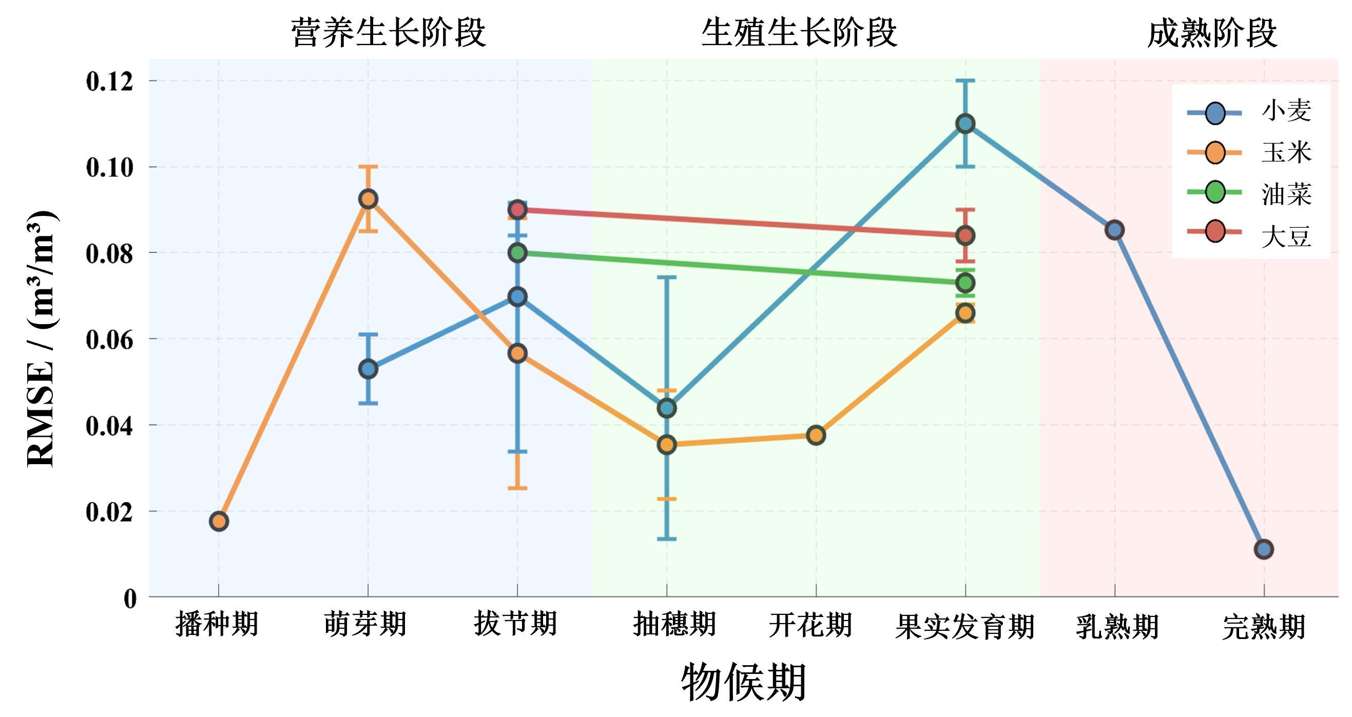
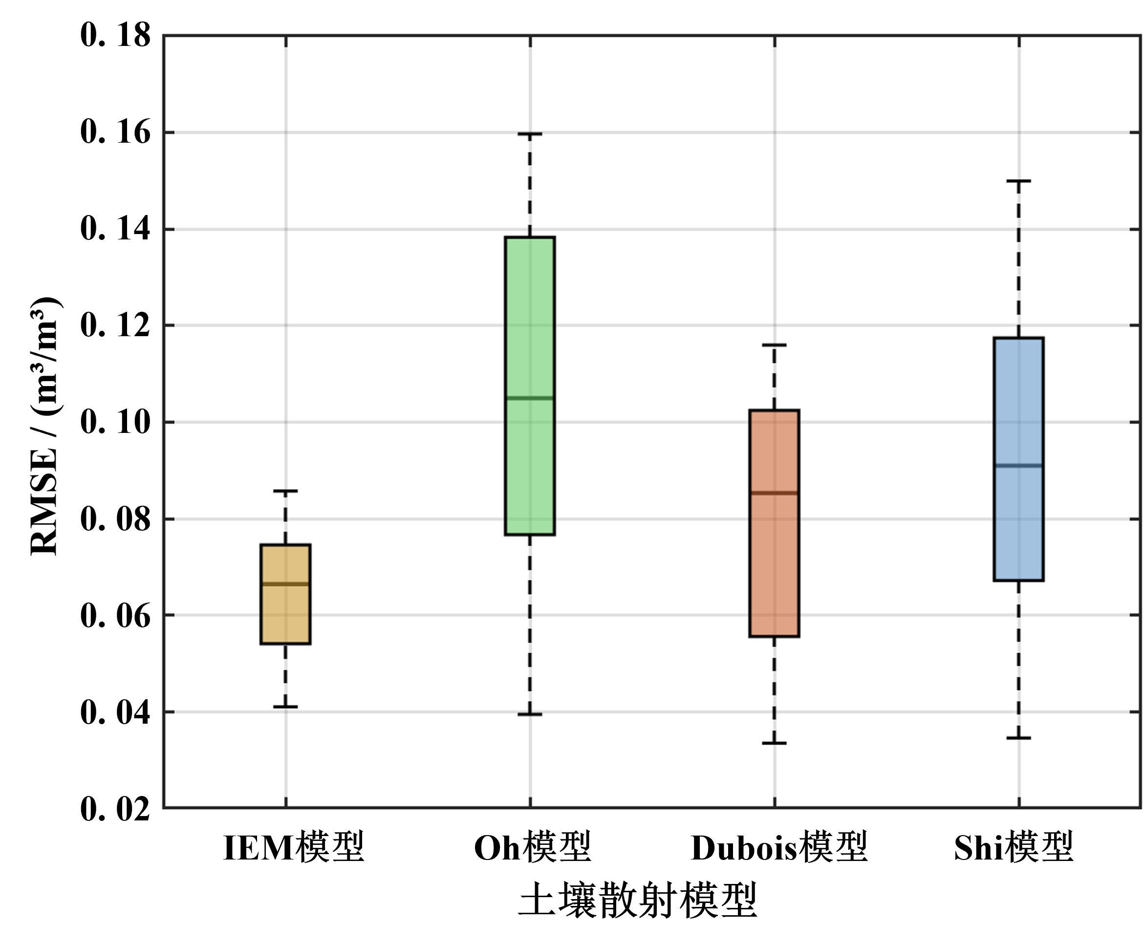
 ), 姜钰杰1, 李翘楚1, 吴昊宇1, 吴尚蓉2, 玉山3, 许磊4, 于亮亮5, 张杰1, 包玉海3