Smart Agriculture ›› 2025, Vol. 7 ›› Issue (6): 225-236.doi: 10.12133/j.smartag.SA202507034
• Special Issue--Remote Sensing + AI Empowering the Modernization of Agriculture and Rural Areas • Previous Articles
CHEN Ailian1, ZHANG Rusheng2, LI Ran2( ), ZHAO Sijian1, ZHU Yuxia1, LAI Jibao2, SUN Wei1, ZHANG Jing1
Received:2025-07-23
Online:2025-11-30
Foundation items:National Natural Science Foundation of China(41471426); National Defense Science and Technology Industry Bureau Major Special Engineering Center Project(2X2X-CGZH-40-202238); Agricultural and Rural Policy Research Fund(B020101)
About author:CHEN Ailian, E-mail: chenailian@caas.cn
corresponding author:
CLC Number:
CHEN Ailian, ZHANG Rusheng, LI Ran, ZHAO Sijian, ZHU Yuxia, LAI Jibao, SUN Wei, ZHANG Jing. Cross-validation Study on the Authenticity of Agricultural Insurance Underwriting Based on Multi-Source Satellite Remote Sensing Data: Taking Multi-Season Rice in M County, S Province as A Case[J]. Smart Agriculture, 2025, 7(6): 225-236.
Add to citation manager EndNote|Ris|BibTeX
URL: https://www.smartag.net.cn/EN/10.12133/j.smartag.SA202507034
Table 1
Phenological patterns of rice in M county
| 水稻类型 | 出苗移栽 | 分蘖拔节 | 孕穗乳熟 | 蜡熟完熟 |
|---|---|---|---|---|
| 早稻 | 3月下旬—4月上旬 | 4月中旬—5月上旬 | 5月中旬—6月中旬 | 6月下旬—7月中旬 |
| 一季稻(中稻) | 4月下旬—5月上旬 | 5月中旬—6月下旬 | 7月上旬—8月下旬 | 9月上旬—10月上旬 |
| 晚稻 | 7月下旬—8月上旬 | 8月中旬—9月上旬 | 9月中旬—10月中旬 | 10月下旬—11月中旬 |
Table 2
Satellite image data parameters used in the study
| 卫星遥感数据 | 时相 | 分辨率 | 水稻所处时期 | 主要用途 |
|---|---|---|---|---|
| 中巴资源卫星04D(CB04D) | 2023年4月1日 | 全色2 m, 多光谱8 m | 早稻出苗移栽器 | 耕地地块提取 |
| 资源1号02D星(ZY1E) | 2023年4月16日 | 全色2.5 m, 多光谱10m | 早稻分蘖期 | 耕地地块提取 |
| 高分1号系列 | 2023年8月4日 2023年8月5日 | 全色 2 m, 多光谱8 m | 中稻孕穗乳熟,早稻出苗移栽期 | 水稻分类(中稻、晚稻) |
| 哨兵2号A星和哨兵2号B星(Sentinel 2A和2B) | 2023年7月、8月 | 2、3、4、8波段10 m;1、9、10波段60 m;5、6、7、11、12波段20 m | 早稻成熟期,中稻孕穗期 | 采样前初分类(早稻、中稻、晚稻) |
| 哨兵1号(Sentinel-1) | 2023年3—10月 | VV极化和VH极化 10m | 整个生长期 | 水稻分类(早稻、中稻、晚稻) |
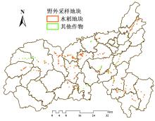
Fig. 1
Field sampling plot distribution map of M county
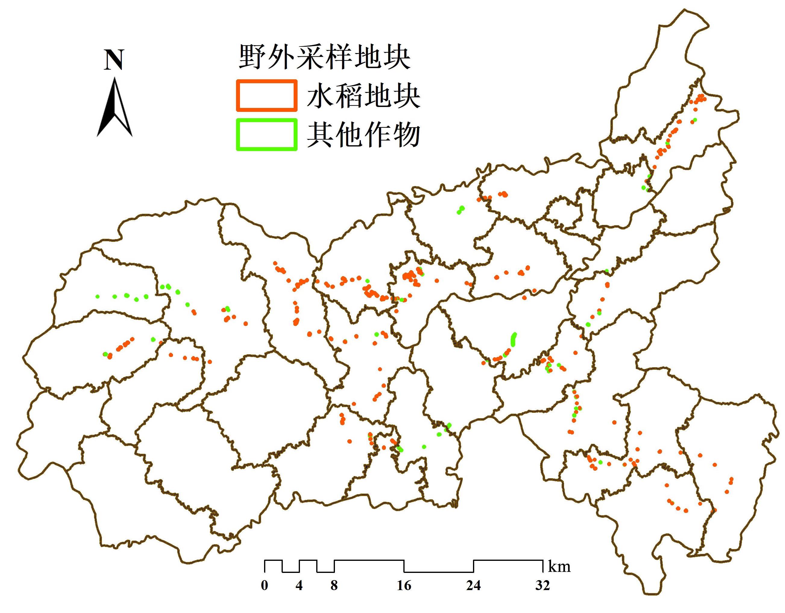
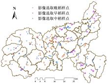
Fig. 2
Distribution of rice sampling points based on (CB04D、ZY1E)image selection

Fig. 3
Cultivated land plot extraction technical process

Table 3
Performance comparison table of ResNet-PSP model extracted from cultivated land plots in M county
| 模型名称 | FLOP | 参数量/Mb | 精度/% | mIoU |
|---|---|---|---|---|
| ResNet-18-psp | 1.82e+09 | 11.18 | 89.34 | 0.61 |
| ResNet-34-psp | 3.67e+09 | 21.8 | 93.52 | 0.69 |
| ResNet-50-psp | 4.13e+09 | 25.56 | 93.89 | 0.71 |
| ResNet-101-psp | 7.84e+09 | 44.55 | 94.21 | 0.72 |
| Inception v3+asp | 7.21e+09 | 23.87 | 93.76 | 0.70 |
| UNet | 2.83e+11 | 31.03 | 92.07 | 0.70 |
| ResUNet | 1.07e+11 | 44.52 | 92.89 | 0.71 |
| EfficientNet-psp | 3.02e+09 | 12.94 | 92.35 | 0.68 |
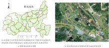
Fig. 4
Cultivated land plot distribution map of M county and partially enlarged area overlapped with satellite image

Table 4
Accuracy performance of three classification methods(RF,SVM,CART)in classifying rice of M county
| 实验组 | 所用数据 | SVM | RF | CART | ||||||
|---|---|---|---|---|---|---|---|---|---|---|
| 最重要的波段 | 总体精度 | Kappa系数 | 最重要的波段 | 总体精度 | Kappa系数 | 最重要的波段 | 总体精度 | Kappa系数 | ||
| 1 | 哨兵1号数据 | 算法不支持 | 0.67 | 0.59 | VH_Sep. VH_Mar. VV_Mar. | 0.78 | 0.72 | VV_Mar. VV_Apr. VH_Mar. | 0.61 | 0.52 |
| 2 | 哨兵1号结合哨兵2号数据 | 0.82 | 0.77 | B5_Jul. B1_Jul. B11_Jul. | 0.93 | 0.91 | B11_Jul. B1_Jul. B12_Jul. | 0.83 | 0.79 | |
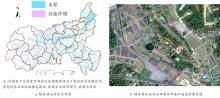
Fig. 5
Rice distribution map of M county and partially enlarged area overlapped with satellite image

Table 5
Cross-validation results of regional underwriting authenticity in M county
| 乡镇 | 区域面积差(AD)/亩 | 区域作物承保覆盖率(CR)/% | ||||||
|---|---|---|---|---|---|---|---|---|
| 早稻 | 中稻 | 晚稻 | 所有水稻 | 早稻 | 中稻 | 晚稻 | 所有水稻 | |
| 乡镇1 | 10 605.84 | 0.00 | 10 048.82 | 30 748.17 | 59.20 | 0.00 | 69.70 | 55.60 |
| 乡镇2 | 4 393.36 | -7 335.09 | 4 010.51 | 1 058.10 | 82.50 | 160.20 | 86.10 | 98.40 |
| 乡镇3 | -34 603.59 | 0.00 | -15 507.36 | -37 283.94 | 275.60 | 0.00 | 169.30 | 167.90 |
| 乡镇4 | 21 630.56 | -10 916.94 | 12 891.21 | 23 660.97 | 37.00 | 234.40 | 65.80 | 70.50 |
| 乡镇5 | 17 080.51 | -9 334.46 | 14 008.88 | 21 750.64 | 21.00 | 224.00 | 41.40 | 59.00 |
| 乡镇6 | 2 344.04 | 0.00 | -13 138.27 | 8 786.44 | 84.20 | 0.00 | 172.20 | 83.30 |
| 乡镇7 | -22 553.64 | 0.00 | -10 624.69 | -19 637.90 | 190.30 | 0.00 | 132.30 | 127.50 |
| 乡镇8 | -278.10 | 0.00 | -9 421.13 | 178.94 | 101.30 | 0.00 | 133.20 | 99.70 |
| 乡镇9 | 3 467.85 | 0.00 | -7 775.15 | 1 932.87 | 76.50 | 0.00 | 146.00 | 94.90 |
| 乡镇10 | -20 745.65 | 0.00 | -16 664.76 | -20 956.02 | 204.00 | 0.00 | 167.00 | 134.20 |
| 乡镇11 | -10 833.76 | 0.00 | 420.66 | 910.99 | 181.70 | 0.00 | 97.20 | 97.70 |
| 乡镇12 | -13 982.17 | 0.00 | -22 857.37 | -18 753.10 | 203.80 | 0.00 | 214.50 | 136.40 |
| 乡镇13 | -2 477.06 | 0.00 | -756.35 | 1 738.62 | 121.10 | 0.00 | 104.70 | 94.70 |
| 乡镇14 | 9 361.69 | -14 762.24 | 9 750.51 | 4 391.54 | 11.70 | 279.70 | 13.10 | 85.40 |
| 乡镇15 | -4 020.59 | -20 636.23 | 4 355.69 | -20 305.60 | 136.80 | 392.00 | 64.90 | 166.80 |
| 乡镇16 | 10 367.08 | -3 769.07 | 8 132.06 | 14 675.72 | 45.60 | 162.30 | 64.50 | 69.40 |
| 乡镇17 | 5 758.53 | 0.00 | -2 799.32 | 10 989.68 | 46.60 | 0.00 | 123.90 | 64.00 |
| 乡镇18 | 9 724.34 | 0.00 | -2 132.74 | 17 112.89 | 59.40 | 0.00 | 107.90 | 71.70 |
| 乡镇19 | 1 689.36 | 0.00 | 2 838.49 | 6 279.25 | 72.40 | 0.00 | 60.30 | 58.20 |
| 乡镇20 | 4 632.48 | 517.14 | -3 581.13 | 1 580.96 | 78.90 | 94.20 | 114.00 | 97.20 |
| 乡镇21 | -36 349.08 | -24 135.78 | -15 093.76 | -75 580.31 | 873.80 | 650.70 | 335.50 | 588.00 |
| 乡镇22 | 687.19 | 68.39 | 467.13 | 1 225.90 | 72.10 | 92.60 | 84.40 | 80.80 |
| 乡镇23 | 4 895.86 | -9 914.31 | 4 789.91 | -299.81 | 2.40 | 429.90 | 5.80 | 102.30 |
| 乡镇24 | -19 064.45 | 3 230.62 | 1 111.00 | -14 731.32 | 198.40 | 65.40 | 95.90 | 126.40 |
| 乡镇25 | 8 019.19 | 0.00 | -271.56 | 13 146.86 | 44.50 | 0.00 | 101.70 | 63.30 |
| 乡镇26 | 5 352.46 | 4 542.03 | 12 728.80 | 22 658.70 | 60.90 | 48.10 | 18.10 | 40.40 |
| 乡镇27 | 2 745.29 | -1 358.75 | 7 104.33 | 8 475.58 | 84.60 | 117.60 | 68.60 | 82.40 |
| 乡镇28 | 1 030.87 | 0.00 | 932.96 | 2 662.33 | 46.60 | 0.00 | 56.10 | 44.00 |
| 乡镇29 | 0.00 | -20 698.44 | 0.00 | 3 092.87 | 0.00 | 326.60 | 0.00 | 87.00 |
| 乡镇30 | 0.00 | 0.00 | -356.10 | -242.08 | 0.00 | 0.00 | 685.50 | 312.30 |
| 乡镇31 | 0.00 | -2 412.79 | 0.00 | 5 246.86 | 0.00 | 1 242.20 | 0.00 | 31.50 |
| 乡镇32 | 0.00 | 0.00 | 0.00 | 0.00 | 0.00 | 0.00 | 0.00 | 0.00 |
| 乡镇33 | 0.00 | 0.00 | 0.00 | 0.00 | 0.00 | 0.00 | 0.00 | 0.00 |
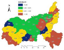
Fig. 6
Rice insurance cover ratio of M county(0-1)

Table 6
Cross-validation results of overlapping ratio of policy plot in M county
| 乡镇 | 地块总数/个 | 面积重叠率 | |||||||||
|---|---|---|---|---|---|---|---|---|---|---|---|
| OR=0% | 0<OR≤5% | 5%<OR≤20% | 20%<OR≤40% | >40% | |||||||
| 地块数/个 | 地块占比/% | 地块数/个 | 地块占比/% | 地块数/个 | 地块占比/% | 地块数/个 | 地块占比/% | 地块数/个 | 地块占比/% | ||
| 乡镇6 | 71 | 43 | 60.60 | 13 | 18.31 | 6 | 8.50 | 4 | 5.60 | 5 | 7.00 |
| 乡镇7 | 380 | 193 | 50.80 | 35 | 9.21 | 36 | 9.50 | 39 | 10.30 | 77 | 20.30 |
| 乡镇8 | 59 | 43 | 72.90 | 10 | 16.95 | 0 | 0.00 | 0 | 0.00 | 6 | 10.20 |
| 乡镇9 | 444 | 203 | 45.70 | 61 | 13.74 | 33 | 7.40 | 48 | 10.80 | 99 | 22.30 |
| 乡镇10 | 92 | 45 | 48.90 | 31 | 33.70 | 3 | 3.30 | 2 | 2.20 | 11 | 12.00 |
| 乡镇11 | 174 | 62 | 35.60 | 3 | 1.72 | 13 | 7.50 | 14 | 8.10 | 82 | 47.10 |
| 乡镇12 | 67 | 50 | 74.60 | 1 | 1.49 | 2 | 3.00 | 7 | 10.50 | 7 | 10.50 |
| 乡镇13 | 73 | 45 | 61.60 | 9 | 12.33 | 3 | 4.10 | 0 | 0.00 | 16 | 21.90 |
| 乡镇14 | 519 | 213 | 41.00 | 57 | 10.98 | 64 | 12.30 | 71 | 13.70 | 114 | 22.00 |
| 乡镇15 | 195 | 97 | 49.70 | 21 | 10.77 | 16 | 8.20 | 14 | 7.20 | 47 | 24.10 |
| 乡镇16 | 459 | 281 | 61.20 | 67 | 14.60 | 21 | 4.60 | 18 | 3.90 | 72 | 15.70 |
| 乡镇17 | 466 | 242 | 51.90 | 80 | 17.17 | 12 | 2.60 | 16 | 3.40 | 116 | 24.90 |
| 乡镇18 | 304 | 71 | 23.40 | 23 | 7.57 | 31 | 10.20 | 37 | 12.20 | 142 | 46.70 |
| 乡镇19 | 130 | 73 | 56.20 | 16 | 12.31 | 7 | 5.40 | 7 | 5.40 | 27 | 20.80 |
| 乡镇20 | 940 | 448 | 47.70 | 151 | 16.06 | 47 | 5.00 | 51 | 5.40 | 243 | 25.90 |
| 乡镇22 | 38 | 38 | 100.00 | 0 | 0.00 | 0 | 0.00 | 0 | 0.00 | 0 | 0.00 |
| 乡镇25 | 139 | 73 | 52.50 | 14 | 10.07 | 15 | 10.80 | 9 | 6.50 | 28 | 20.10 |
| 乡镇28 | 3 | 3 | 100.00 | 0 | 0.00 | 0 | 0.00 | 0 | 0.00 | 0 | 0.00 |
| 乡镇30 | 187 | 65 | 34.80 | 9 | 4.81 | 5 | 2.70 | 13 | 7.00 | 95 | 50.80 |
| 乡镇31 | 313 | 150 | 47.90 | 37 | 11.82 | 26 | 8.30 | 28 | 9.00 | 72 | 23.00 |
| 乡镇32 | 387 | 203 | 52.50 | 38 | 9.82 | 31 | 8.00 | 35 | 9.00 | 80 | 20.70 |
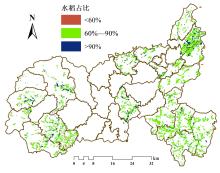
Fig. 7
Crop proportion of rice in policy plots in M county

| [1] |
薛璐瑶,赵思健. 农业保险"两虚"问题研究: 形成机理、治理策略及未来展望[J/OL]. 农业展望, 1-13[2025-12-31].
|
|
|
|
| [2] |
南方农村报. 中国农险保费规模全球第一[EB/OL]. 2025-03-08.
|
| [3] |
|
| [4] |
陈爱莲, 赵思健, 朱玉霞, 等. 遥感技术在种植收入保险中的应用场景及研究进展[J]. 智慧农业(中英文), 2022, 4(1): 57-70.
|
|
|
|
| [5] |
|
| [6] |
|
| [7] |
|
| [8] |
|
| [9] |
|
| [10] |
|
| [11] |
张兰. 农险"用腿理赔"或将终结[N]. 金融时报, 2013-10-21(5).
|
| [12] |
郭清, 何飞. 空间信息技术在农业保险中的应用研究[J]. 地理信息世界, 2014, 21(1): 79-84.
|
|
|
|
| [13] |
王珊. 遥感技术防范烟叶种植险道德风险问题研究: 以云南省为例[D]. 昆明: 云南财经大学, 2022.
|
|
|
|
| [14] |
庄家煜, 包维嘉, 苏武峥. 农业遥感应用现状与展望[J]. 农业展望, 2024, 20(4): 68-74.
|
|
|
|
| [15] |
陈爱莲, 李家裕, 张圣军, 等. 卫星遥感估产技术在大豆区域收入保险中的应用[J]. 智慧农业(中英文), 2020, 2(3): 139-152.
|
|
|
|
| [16] |
鄂海林, 周德成, 李坤. 基于Sentinel 1/2和GEE的水稻种植面积提取方法: 以杭嘉湖平原为例[J]. 智慧农业(中英文), 2025(2): 81-94.
|
|
|
|
| [17] |
魏萱, 蒋一凡, 蔡玥乐, 等. 农业无人机高光谱成像遥感研究现状和进展[J]. 中国农业信息, 2024, 36(4): 27-46.
|
|
|
|
| [18] |
齐腊, 刘良云, 赵春江, 等. 基于遥感影像时间序列的冬小麦种植监测最佳时相选择研究[J]. 遥感技术与应用, 2008, 23(2): 154-160.
|
|
|
|
| [19] |
赵荣荣, 丛楠, 赵闯, 等. 基于Landsat 8影像提取豫中地区冬小麦和夏玉米分布信息的最佳时相选择[J]. 作物学报, 2024, 50(3): 721-733.
|
|
|
|
| [20] |
沈宇, 李强子, 杜鑫, 等. 玉米大豆生长中后期遥感辨识的指示性特征研究[J]. 遥感学报, 2022, 26(7): 1410-1422.
|
|
|
|
| [21] |
赵思健, 赵坚, 陈爱莲, 等. 遥感交叉验证农业保险数据的路径与指标研究[J]. 保险研究, 2024(1): 49-58.
|
|
|
|
| [22] |
刘文双. 基于时序多特征SAR影像的水稻解译研究[J]. 测绘与空间地理信息, 2025, 48(6): 91-94, 98.
|
|
|
|
| [23] |
高心怡, 池泓, 黄进良, 等. 水稻遥感制图研究综述[J]. 遥感学报, 2024, 28(9): 2144-2169.
|
|
|
|
| [24] |
|
| [25] |
|
| [1] | LIU Jie, GUO Jiaxin, ZHANG Jiahao, ZHANG Bingchao, XIONG Jie, CAO Jianpeng, WU Shangrong, DENG Yingbin, CHEN Guipeng. Method for Estimating Leaf Area Index of Winter Rapeseed Based on Fusion of Vegetation Indices and Texture Features [J]. Smart Agriculture, 2025, 7(6): 161-173. |
| [2] | LAI Jiazheng, LI Beibei, CHENG Xiang, SUN Feng, CHENG Juting, WANG Jing, ZHANG Qian, YE Xiefeng. Monitoring of Leaf Chlorophyll Content in Flue-Cured Tobacco Based on Hyperspectral Remote Sensing of Unmanned Aerial Vehicle [J]. Smart Agriculture, 2023, 5(2): 68-81. |
| [3] | FAN Chengzhi, WANG Ziwen, YANG Xingchao, LUO Yongkai, XU Xuexin, GUO Bin, LI Zhenhai. Machine Learning Inversion Model of Soil Salinity in the Yellow River Delta Based on Field Hyperspectral and UAV Multispectral Data [J]. Smart Agriculture, 2022, 4(4): 61-73. |
| [4] | CHEN Ailian, ZHAO Sijian, ZHU Yuxia, SUN Wei, ZHANG jing, ZHANG Qiao. Application Scenarios and Research Progress of Remote Sensing Technology in Plant Income Insurance [J]. Smart Agriculture, 2022, 4(1): 57-70. |
| [5] | LI Dongbo, HUANG Lyuwen, ZHAO Xubo. Detection Method of Apple Mould Core Based on Dielectric Characteristics [J]. Smart Agriculture, 2021, 3(4): 66-76. |
| [6] | YIN Hang, LI Xiangtong, XU Longqin, LI Jingbin, LIU Shuangyin, CAO Liang, FENG Dachun, GUO Jianjun, LI Liqiao. EMD-RF-LSTM: Combination Prediction Model of Dissolved Oxygen Concentration in Prawn Culture [J]. Smart Agriculture, 2021, 3(2): 115-125. |
| [7] | CHEN Ailian, LI Jiayu, ZHANG Shengjun, ZHU Yuxia, ZHAO Sijian, SUN Wei, ZHANG Qiao. Application of Satellite Remote Sensing Yield Estimation Technology in Regional Revenue Protection Crop Insurance: A Case of Soybean [J]. Smart Agriculture, 2020, 2(3): 139-152. |
| [8] | SHAO Guomin, WANG Yajie, HAN Wenting. Estimation Method of Leaf Area Index for Summer Maize Using UAV-Based Multispectral Remote Sensing [J]. Smart Agriculture, 2020, 2(3): 118-128. |
| [9] | LIU Tianlin, ZHU Xicun, BAI Xueyuan, PENG Yufeng, LI Meixuan, TIAN Zhongyu, JIANG Yuanmao, YANG Guijun. Hyperspectral Estimation Model Construction and Accuracy Comparison of Soil Organic Matter Content [J]. Smart Agriculture, 2020, 2(3): 129-138. |
| Viewed | ||||||
|
Full text |
|
|||||
|
Abstract |
|
|||||


