| [1] |
吴志峰, 骆剑承, 孙营伟, 等. 时空协同的精准农业遥感研究[J]. 地球信息科学学报, 2020, 22(4): 731-742.
|
|
WU Z F, LUO J C, SUN Y W, et al. Research on precision agricultural based on the spatial-temporal remote sensing collaboration[J]. Journal of geo-information science, 2020, 22(4): 731-742.
|
| [2] |
胡琼, 吴文斌, 宋茜, 等. 农作物种植结构遥感提取研究进展[J]. 中国农业科学, 2015, 48(10): 1900-1914.
|
|
HU Q, WU W B, SONG Q, et al. Recent progresses in research of crop patterns mapping by using remote sensing[J]. Scientia agricultura sinica, 2015, 48(10): 1900-1914.
|
| [3] |
SALMON J M, FRIEDL M A, FROLKING S, et al. Global rain-fed, irrigated, and paddy croplands: A new high resolution map derived from remote sensing, crop inventories and climate data[J]. International journal of applied earth observation and geoinformation, 2015, 38: 321-334.
|
| [4] |
YANG C H. Remote sensing and precision agriculture technologies for crop disease detection and management with a practical application example[J]. Engineering, 2020, 6(5): 102-112.
|
| [5] |
张冬韵, 吴田军, 李曼嘉, 等. 地块尺度农作物遥感分类及其不确定性分析[J]. 自然资源遥感, 2024, 36(4): 124-134.
|
|
ZHANG D Y, WU T J, LI M J, et al. Remote sensing-based classification of crops on a farmland parcel scale and uncertainty analysis[J]. Remote sensing for natural resources, 2024, 36(4): 124-134.
|
| [6] |
吴炳方, 张淼, 曾红伟, 等. 大数据时代的农情监测与预警[J]. 遥感学报, 2016, 20(5): 1027-1037.
|
|
WU B F, ZHANG M, ZENG H W, et al. Agricultural monitoring and early warning in the era of big data[J]. Journal of remote sensing, 2016, 20(5): 1027-1037.
|
| [7] |
WEISS M, JACOB F, DUVEILLER G. Remote sensing for agricultural applications: A meta-review[J]. Remote sensing of environment, 2020, 236: ID 111402.
|
| [8] |
宋茜, 胡琼, 陆苗, 等. 农作物空间分布遥感制图发展方向探讨[J]. 中国农业资源与区划, 2020, 41(6): 57-65.
|
|
SONG Q, HU Q, LU M, et al. Prospect of crop mapping[J]. Chinese journal of agricultural resources and regional planning, 2020, 41(6): 57-65.
|
| [9] |
冯如意, 王力哲, 曾铁勇. 高光谱遥感图像亚像元信息提取方法综述[J]. 测绘学报, 2023, 52(7): 1187-1201.
|
|
FENG R Y, WANG L Z, ZENG T Y. Review of hyperspectral remote sensing image subpixel information extraction[J]. Acta geodaetica et cartographica sinica, 2023, 52(7): 1187-1201.
|
| [10] |
BUI C V, VO Q T, VUONG N L. GAN vs. traditional methods: A multi-scale performance evaluation in satellite image classification[C]// 2024 IEEE International Conference on Consumer Electronics-Asia (ICCE-Asia). Piscataway, New Jersey, USA: IEEE, 2024: 1-4.
|
| [11] |
GARCÍA REYES R A. Geographic information system and remote sensing for the evaluation of the aptitude of rice lands in the mayarí agroecosystem, holguín[J]. Modern concepts & developments in agronomy, 2022, 11(2). 2811-2830.
|
| [12] |
LI H, ZHANG C, ZHANG Y, et al. A scale sequence objectbased convolutional neural network(SS-OCNN)for crop classification from fine spatial resolution remotely sensed imagery[J]. International journal of digital earth, 2021, 14(11): 1528-1546.
|
| [13] |
ZHANG P, HU S G, LI W D, et al. Improving parcel-level mapping of smallholder crops from VHSR imagery: An ensemble machine-learning-based framework[J]. Remote sensing, 2021, 13(11): ID 2146.
|
| [14] |
ERDANAEV E, KAPPAS M, WYSS D. The identification of irrigated crop types using support vector machine, random forest and maximum likelihood classification methods with Sentinel-2 data in 2018: Tashkent province, Uzbekistan[J/OL]. International journal of geoinformatics, 2022, 18(2). [2025-08-20].
|
| [15] |
YILMAZ C, GUNGOR O. Improving SVM classification accuracy with image fusion-based gabor texture features[EB/OL]. [2025-08-20].
|
| [16] |
RATANOPAD SUWANLEE S, KEAWSOMSEE S, IZQUIERDO-VERDIGUIER E, et al. Mapping sugarcane plantations in Northeast Thailand using multi-temporal data from multi-sensors and machine-learning algorithms[J]. Big earth data, 2025, 9(2): 187-216.
|
| [17] |
邓刘洋, 沈占锋, 柯映明, 等. 基于地块尺度多时相遥感影像的冬小麦种植面积提取[J]. 农业工程学报, 2018, 34(21): 157-164.
|
|
DENG L Y, SHEN Z F, KE Y M, et al. Extraction of winter wheat planting area based on multi-temporal remote sensing images at plot scale[J]. Transactions of the Chinese society of agricultural engineering, 2018, 34(21): 157-164.
|
| [18] |
NARIN O G, ABDIKAN S, BAYIK C, et al. Coherence and backscatter based cropland mapping using multi-temporal sentinel-1 with dynamic time warping[J]. The international archives of the photogrammetry, remote sensing and spatial information sciences, 2021, XLIII-B5-2021: 37-41.
|
| [19] |
王志华, 杨晓梅, 刘岳明, 等. 遥感影像地学分析的地理学原理及等级斑块建模框架[J]. 遥感学报, 2024, 28(6): 1412-1424.
|
|
WANG Z H, YANG X M, LIU Y M, et al. Geographical principle and hierarchical patch modeling framework for geo-analysis of remote sensing images[J]. National remote sensing bulletin, 2024, 28(6): 1412-1424.
|
| [20] |
刘巍, 吴志峰, 骆剑承, 等. 深度学习支持下的丘陵山区耕地高分辨率遥感信息分区分层提取方法[J]. 测绘学报, 2021, 50(1): 105-116.
|
|
LIU W, WU Z F, LUO J C, et al. High-resolution remote sensing information partition and hierarchical extraction method of cultivated land in hilly and mountainous areas supported by deep learning[J]. Acta geodaetica et cartographica sinica, 2021, 50(1): 105-116.
|
| [21] |
骆剑承, 吴田军,吴志峰, 等. 遥感大数据智能计算[M]. 北京: 科学出版社, 2020.
|
| [22] |
FENG T, ZHU Y H, CHAI N, et al. Increased grain yield in modern genotypes of spring wheat for dryland cultivation in northwest China is associated with the decreased allocation of carbon to roots[J]. Field crops research, 2023, 303: ID 109114.
|
| [23] |
杨颖频, 吴志峰, 骆剑承, 等. 时空协同的地块尺度作物分布遥感提取[J]. 农业工程学报, 2021, 37(7): 166-174.
|
|
YANG Y P, WU Z F, LUO J C, et al. Remote sensing extraction of crop distribution at plot scale based on spatio-temporal collaboration[J]. Transactions of the Chinese society of agricultural engineering, 2021, 37(7): 166-174.
|
| [24] |
寇雯齐, 沈占锋, 王浩宇, 等. 复杂场景下小农经营区地块级苹果园模块化制图方法框架[J]. 地球信息科学学报, 2024, 26(1): 197-211.
|
|
KOU W Q, SHEN Z F, WANG H Y, et al. Modular mapping method framework of plot-level apple orchards in small-scale peasant management areas under complex scenes[J]. Journal of geo-information science, 2024, 26(1): 197-211.
|
| [25] |
秦肖伟, 程博, 杨志平, 等. 基于时序遥感影像的西南山区地块尺度作物类型识别[J]. 地球信息科学学报, 2023, 25(3): 654-668.
|
|
QIN X W, CHENG B, YANG Z P, et al. Identification of crop types at plot scale in southwest mountainous areas based on time series remote sensing images[J]. Journal of geo-information science, 2023, 25(3): 654-668.
|
| [26] |
JIAO S H, HU D X, SHEN Z F, et al. Parcel-level mapping of horticultural crop orchards in complex mountain areas using VHR and time-series images[J]. Remote sensing, 2022, 14(9): ID 2015.
|
| [27] |
QU T F, WANG H, LI X B, et al. A fine crop classification model based on multitemporal Sentinel-2 images[J]. International journal of applied earth observation and geoinformation, 2024, 134: ID 104172.
|
| [28] |
RUßWURM M, KÖRNER M. Multi-temporal land cover classification with long short-term memory neural networks[J]. The international archives of the photogrammetry, remote sensing and spatial information sciences, 2017, XLII-1/W1: 551-558.
|
| [29] |
刘灵, 张加龙, 韩雪莲, 等. 基于GEE和Sentinel时序影像的优势树种识别研究[J]. 森林工程, 2023, 39(1): 63-72, 81.
|
|
LIU L, ZHANG J L, HAN X L, et al. Study on identification of dominant tree species based on GEE and Sentinel time series images[J]. Forest engineering, 2023, 39(1): 63-72, 81.
|
| [30] |
MUSTAFA STÜNER, ABDIKAN S, BILGIN G, et al. Crop classification using light gradient boosting machines[J/OL]. Turkish Journal of RemOte Sensing and GlS.[2025-08-20].
|
| [31] |
冯蕴雯, 崔宇航, 贺谦, 等. 基于ISMA-Stacking集成建模和贝叶斯融合的全机结构试验可靠性评估[J/OL]. 航空学报. (2025-07-28)[2025-08-29].
|
|
FENG Y W, CUI Y H, HE Q, et al. Reliability assessment of full-scale structural tests based on ISMA-stacking ensemble modeling and bayesian fusion[J/OL]. Acta Aeronautica et Astronautica Sinica. (2025-07-28)[2025-08-29].
|
| [32] |
CHEN T Q, GUESTRIN C. XGBoost: A scalable tree boosting system[C]// Proceedings of the 22nd ACM SIGKDD International Conference on Knowledge Discovery and Data Mining. San Francisco, California, USA: ACM, 2016: 785-794.
|
| [33] |
HARIYANI G, SINGH A, PATIL P, et al. Analysis on crop yield prediction using various ensemble methods[C]// 2024 8th International Conference on Computing, Communication, Control and Automation (ICCUBEA). Piscataway, New Jersey, USA: IEEE, 2024: 1-6.
|
| [34] |
REDDY N V V, MANIMEGALAI T. Predicting the crop yield in agriculture using gradient boosting algorithm in comparison of naive Bayes algorithm[J]. Fifth international conference on applied sciences: ICAS2023, 2024, 3097: ID 020201.
|
| [35] |
SIKARWAR S S, PANDEY S, KUMAR S A, et al. Optimizing crop yield predictions using K-nearest neighbors regression: An analysis of temperature, rainfall and soil pH influences[C]// 2024 1st International Conference on Advances in Computing, Communication and Networking (ICAC2N). Piscataway, New Jersey, USA: IEEE, 2025: 1336-1341.
|
| [36] |
WANG H Y, WANG J, SHEN Z F, et al. Parcel-level mapping of apple orchard in smallholder agriculture areas based on feature-level fusion of VHR image and time-series images[J]. International journal of remote sensing, 2022, 43(17): 6195-6220.
|
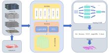
 ), 董文2, 郑逸榛2,3, 程博1,2, 涂文丽4, 孙凤青4