Smart Agriculture ›› 2025, Vol. 7 ›› Issue (6): 196-209.doi: 10.12133/j.smartag.SA202509003
• Special Issue--Remote Sensing + AI Empowering the Modernization of Agriculture and Rural Areas • Previous Articles Next Articles
XIE Wenhao1,2, ZHANG Xin1,2( ), DONG Wen2, ZHENG Yizhen2,3, CHENG Bo1,2, TU Wenli4, SUN Fengqing4
Received:2025-08-30
Online:2025-11-30
Foundation items:National Key R&D Program Project(2021YFB3901300)
About author:XIE Wenhao, E-mail: 17879904646@163.com
corresponding author:
CLC Number:
XIE Wenhao, ZHANG Xin, DONG Wen, ZHENG Yizhen, CHENG Bo, TU Wenli, SUN Fengqing. Parcel-Scale Crop Distribution Mapping Based on Stacking Ensemble Learning[J]. Smart Agriculture, 2025, 7(6): 196-209.
Add to citation manager EndNote|Ris|BibTeX
URL: https://www.smartag.net.cn/EN/10.12133/j.smartag.SA202509003

Fig. 1
Location of the study area and sample distribution map

Table 1
Statistics of plot sample numbers for each crop type
| 样本类型 | 地块样本数量 |
|---|---|
| 玉米 | 2 198 |
| 花生 | 100 |
| 大豆 | 299 |
| 桃 | 113 |
| 苹果 | 150 |
| 番薯 | 77 |
| 菜花 | 135 |
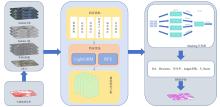
Fig. 2
Workflow of multi-scale feature fusion ensemble crop classification model
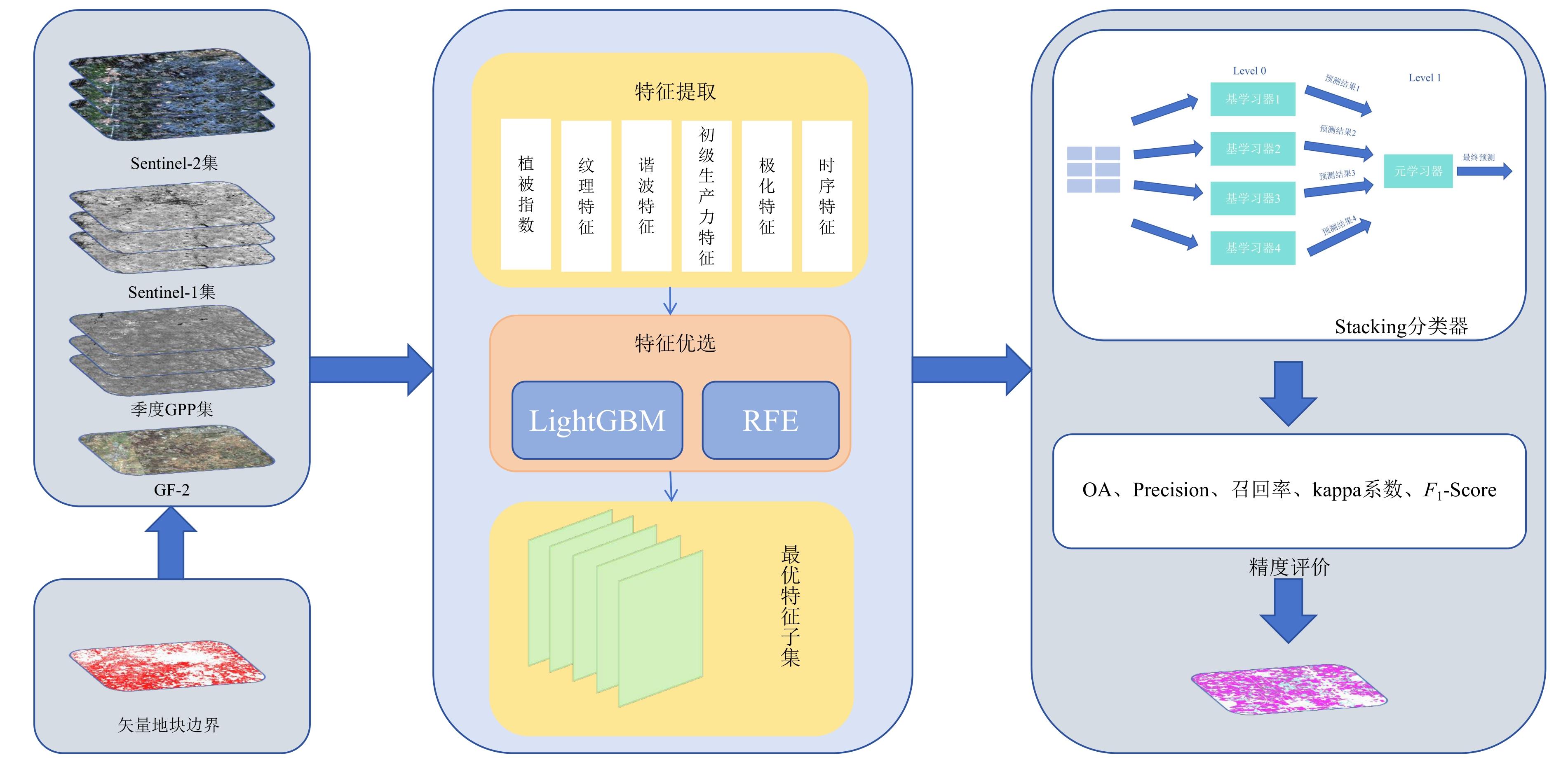
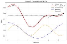
Fig. 3
Schematic of harmonic feature extraction based on time-series decomposition (K = 2)

Table 2
Types and calculation methods of multi-source remote sensing features for field-scale crop classification
| 类别 | 计算方法 |
|---|---|
| 光谱特征 | 统计地块内各波段均值、标准差等,用波段值计算各植被指数(NDVI、SAVI、GNDVI、NDWI、GBNDVI、VARI、EVI、TVI、ARVI、VDVI、RDVI) |
| 雷达特征 | VV、VH极化在地块内的均值、标准差 |
| 纹理特征 | 在地块内计算GLCM的对比度、同质性、相关性、熵和二阶矩,并取均值作为整体表征 |
| 生产力特征 | 地块内的GPP值取月均值,反映作物生物量积累水平 |
| 时序特征 | 基于地块时序曲线进行谐波分解,提取基频、振幅、相位等谐波特征;将地块的多时相曲线输入LSTM,输出学习到的深层时序特征 |
Fig. 4
Stacking classifier framework diagram
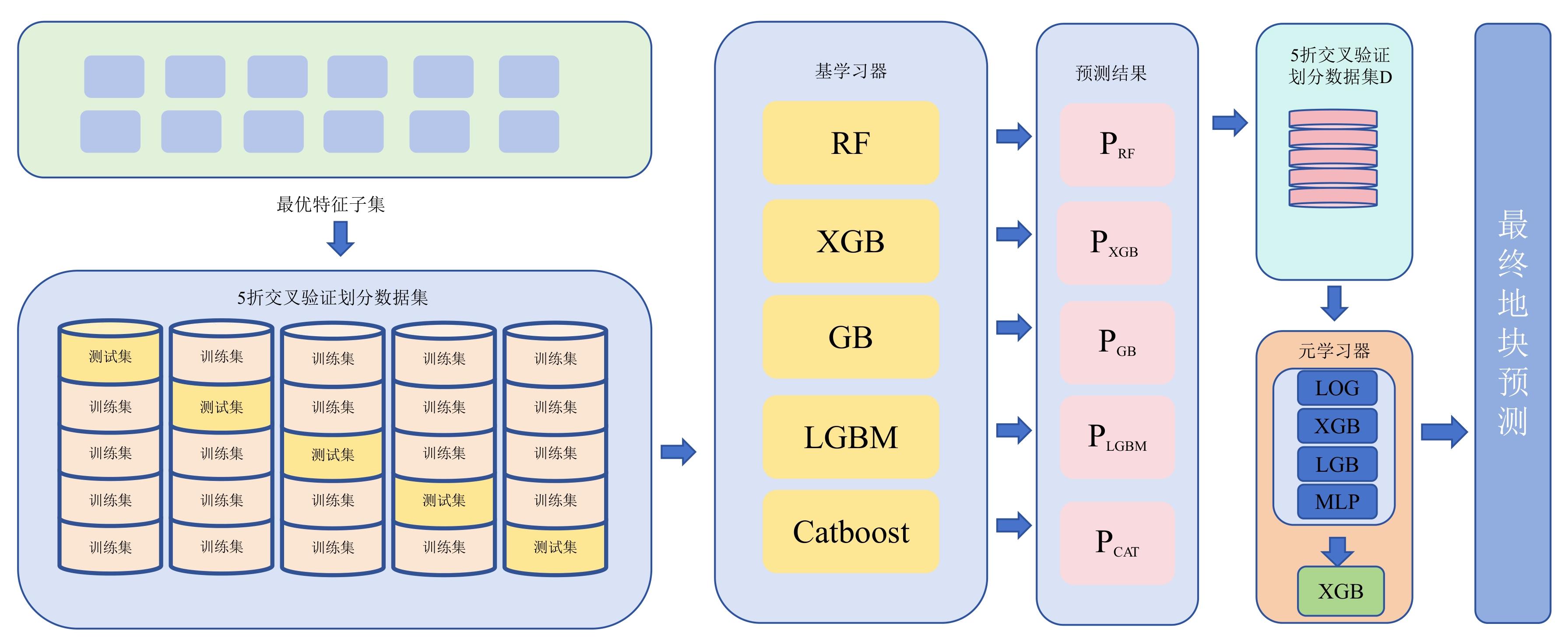
Table 3
Precision evaluation indicators and calculation methods
| 指标名称 | 计算公式 |
|---|---|
| Overall accuracy(OA) | (1) |
| Precision | (2) |
| Recall | (3) |
| Kappa系数 | (4) |
| F 1-Score | (5) |

Fig. 5
Detailed view of stacking method results
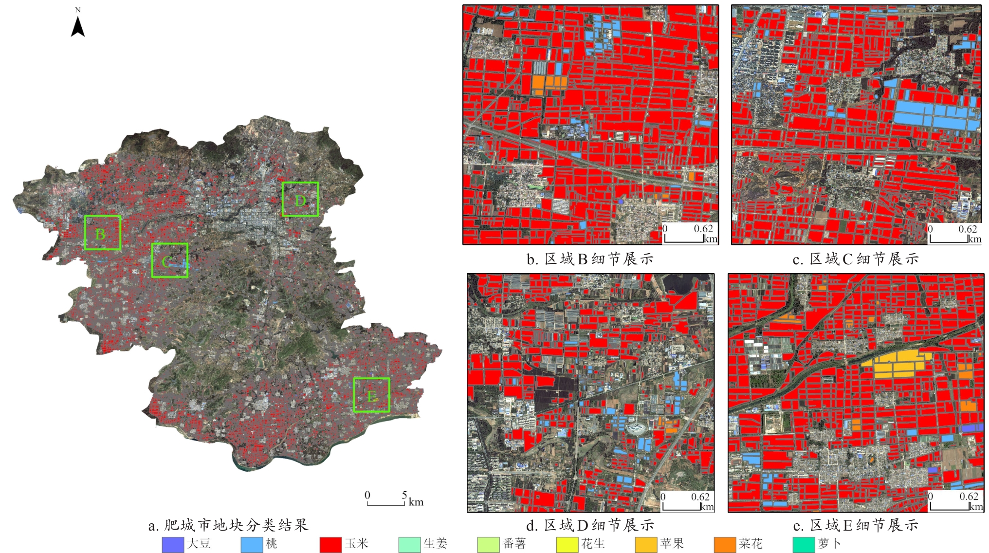
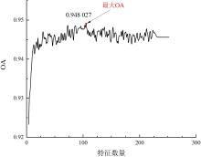
Fig. 6
Effect of optimal feature subset on classification accuracy
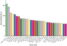
Fig. 7
Importance scores for features in the optimal feature subset

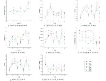
Fig. 8
Comparison of multisource temporal features among different crops

Table 4
Parameter settings for each base learner
| 模型 | 最优参数设置 |
|---|---|
| RF | n_estimators=325, max_depth=15, min_samples_split=3, min_samples_leaf=1, random_state=42 |
| XGB | n_estimators=254, max_depth=9,learning_rate=0.186, gamma=0.013, min_child_weight=3, subsample=0.95, colsample_bytree=0.645, random_state=10 |
| AdaBoost | estimator=DecisionTreeClassifier(max_depth=9), n_estimators=417,learning_rate=0.056 5, algorithm='SAMME', random_state=50 |
| LGBM | n_estimators=491, learning_rate=0.060 4, num_leaves=68, max_bin=111, random_state=42 |
| GB | n_estimators=252, learning_rate=0.193, max_depth=9, min_samples_split=5, min_samples_leaf=2, subsample=0.8, random_state=42 |
| CatBoost | iterations=963, depth=7, learning_rate=0.226, l2_leaf_reg=1.56, random_seed=42, verbose=False |
| SVM | kernel='rbf', C=8.5, gamma=0.064, probability=True, random_state=42 |
| BP | hidden_layer_sizes=(294 251), activation='relu', solver='adam', alpha=0.000 42, max_iter=1 000, learning_rate='adaptive', learning_rate_init=0.036, random_state=42 |
| KNN | n_neighbors=6, weights='distance' |
Table 5
Comparison of base classifier performance
| 模型名称 | F 1-macro均值 | 标准差 |
|---|---|---|
| RF | 0.890 5 | 0.018 7 |
| XGB | 0.896 6 | 0.017 3 |
| SVM | 0.141 5 | 0.033 4 |
| GB | 0.824 3 | 0.046 1 |
| KNN | 0.556 5 | 0.036 0 |
| LightGBM | 0.906 9 | 0.009 3 |
| Catboost | 0.918 3 | 0.006 1 |
| BP | 0.103 9 | 0.000 1 |
| ADA | 0.866 2 | 0.029 3 |
Table 6
Key hyperparameter settings of meta-models in the stacking ensemble
| 元模型 | 最优参数设置 |
|---|---|
| LGBMClassifier | n_estimators=50,learning_rate=0.05,random_state=42 |
| XGBClassifier | n_estimators=50,learning_rate=0.05,num_leaves=68,max_bin=111,random_state=42 |
| MLPClassifier | hidden_layer_sizes=(100,),activation='relu',solver='adam',learning_rate='adaptive',learning_rate_init=0.036,max_iter=500,random_state=42 |
| LogisticRegression | solver='lbfgs',max_iter=1 000,C=1.0,random_state=42 |
Table 7
Performance comparison of different classifiers for parcel-level and pixel-level crop classification
| 元学习器 | OA/% | Kappa |
|---|---|---|
| 地块分类结果 | ||
| XGBClassifier | 95.66 | 0.900 6 |
| LGBMClassifier | 95.23 | 0.896 6 |
| MLPClassifier | 94.90 | 0.889 3 |
| LogisticRegression | 95.12 | 0.894 4 |
| 像素分类结果 | ||
| XGBClassifier | 93.96 | 0.914 3 |
| LGBMClassifier | 93.56 | 0.911 3 |
| MLPClassifier | 93.37 | 0.906 1 |
| LogisticRegression | 92.89 | 0.901 1 |
Fig. 9
Comparison of confusion matrices of different meta-learners for field-scale crop classification
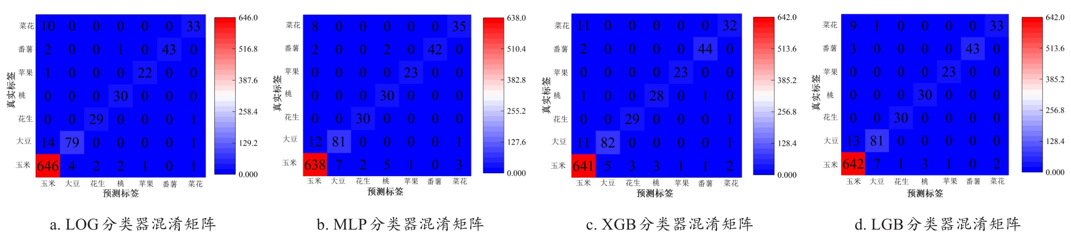
Table 8
Class-wise accuracy metrics of XGBClassifier
| 作物类型 | Precision | Recall | F 1 -Score |
|---|---|---|---|
| 玉米 | 0.962 5 | 0.977 1 | 0.969 7 |
| 大豆 | 0.942 5 | 0.872 3 | 0.906 1 |
| 花生 | 0.906 2 | 0.966 7 | 0.935 5 |
| 桃 | 0.903 2 | 0.933 3 | 0.918 0 |
| 番薯 | 0.958 3 | 1.000 0 | 0.978 7 |
| 苹果 | 0.956 5 | 0.956 5 | 0.956 5 |
| 菜花 | 0.888 9 | 0.744 2 | 0.810 1 |
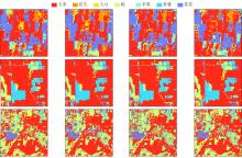
Fig. 10
Pixel-level classification details for different methods
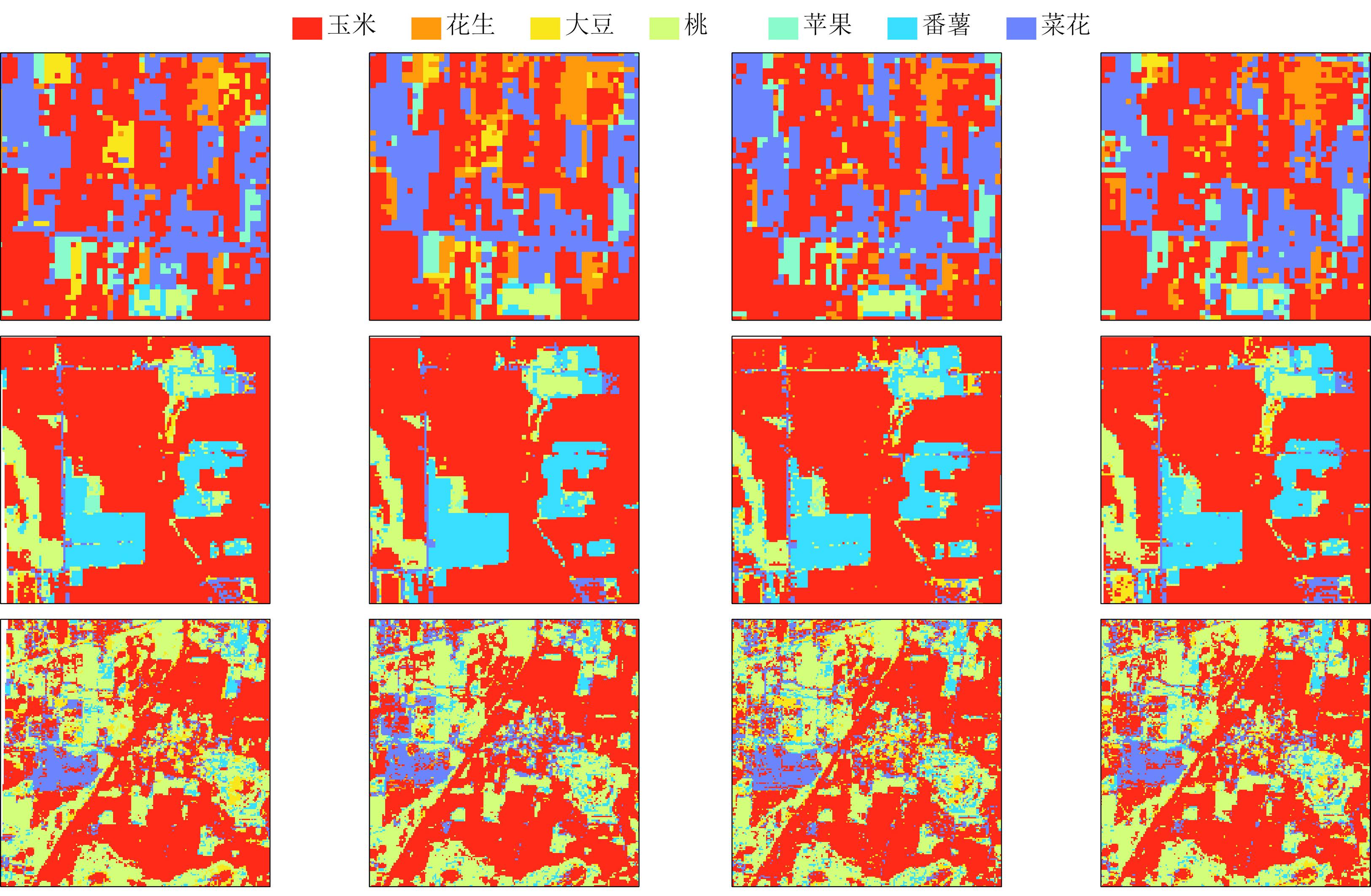
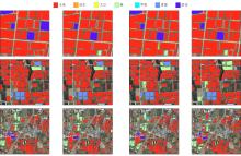
Fig. 11
Detailed map of plot-level classification by different methods

Table 9
Comparison of classification overall accuracy at pixel level and plot level in boundary areas
| 模型 | 方法 | ||
|---|---|---|---|
| 众数法 | 元特征法 | 地块对象法 | |
| XGBClassifier | 0.936 9 | 0.938 5 | 0.956 6 |
| LGBMClassifier | 0.933 2 | 0.936 9 | 0.952 3 |
| MLPClassifier | 0.934 7 | 0.943 5 | 0.949 0 |
| LogisticRegression | 0.932 5 | 0.944 3 | 0.951 2 |
| [1] |
吴志峰, 骆剑承, 孙营伟, 等. 时空协同的精准农业遥感研究[J]. 地球信息科学学报, 2020, 22(4): 731-742.
|
|
|
|
| [2] |
胡琼, 吴文斌, 宋茜, 等. 农作物种植结构遥感提取研究进展[J]. 中国农业科学, 2015, 48(10): 1900-1914.
|
|
|
|
| [3] |
|
| [4] |
|
| [5] |
张冬韵, 吴田军, 李曼嘉, 等. 地块尺度农作物遥感分类及其不确定性分析[J]. 自然资源遥感, 2024, 36(4): 124-134.
|
|
|
|
| [6] |
吴炳方, 张淼, 曾红伟, 等. 大数据时代的农情监测与预警[J]. 遥感学报, 2016, 20(5): 1027-1037.
|
|
|
|
| [7] |
|
| [8] |
宋茜, 胡琼, 陆苗, 等. 农作物空间分布遥感制图发展方向探讨[J]. 中国农业资源与区划, 2020, 41(6): 57-65.
|
|
|
|
| [9] |
冯如意, 王力哲, 曾铁勇. 高光谱遥感图像亚像元信息提取方法综述[J]. 测绘学报, 2023, 52(7): 1187-1201.
|
|
|
|
| [10] |
|
| [11] |
|
| [12] |
|
| [13] |
|
| [14] |
|
| [15] |
|
| [16] |
|
| [17] |
邓刘洋, 沈占锋, 柯映明, 等. 基于地块尺度多时相遥感影像的冬小麦种植面积提取[J]. 农业工程学报, 2018, 34(21): 157-164.
|
|
|
|
| [18] |
|
| [19] |
王志华, 杨晓梅, 刘岳明, 等. 遥感影像地学分析的地理学原理及等级斑块建模框架[J]. 遥感学报, 2024, 28(6): 1412-1424.
|
|
|
|
| [20] |
刘巍, 吴志峰, 骆剑承, 等. 深度学习支持下的丘陵山区耕地高分辨率遥感信息分区分层提取方法[J]. 测绘学报, 2021, 50(1): 105-116.
|
|
|
|
| [21] |
骆剑承, 吴田军,吴志峰, 等. 遥感大数据智能计算[M]. 北京: 科学出版社, 2020.
|
| [22] |
|
| [23] |
杨颖频, 吴志峰, 骆剑承, 等. 时空协同的地块尺度作物分布遥感提取[J]. 农业工程学报, 2021, 37(7): 166-174.
|
|
|
|
| [24] |
寇雯齐, 沈占锋, 王浩宇, 等. 复杂场景下小农经营区地块级苹果园模块化制图方法框架[J]. 地球信息科学学报, 2024, 26(1): 197-211.
|
|
|
|
| [25] |
秦肖伟, 程博, 杨志平, 等. 基于时序遥感影像的西南山区地块尺度作物类型识别[J]. 地球信息科学学报, 2023, 25(3): 654-668.
|
|
|
|
| [26] |
|
| [27] |
|
| [28] |
|
| [29] |
刘灵, 张加龙, 韩雪莲, 等. 基于GEE和Sentinel时序影像的优势树种识别研究[J]. 森林工程, 2023, 39(1): 63-72, 81.
|
|
|
|
| [30] |
|
| [31] |
冯蕴雯, 崔宇航, 贺谦, 等. 基于ISMA-Stacking集成建模和贝叶斯融合的全机结构试验可靠性评估[J/OL]. 航空学报. (2025-07-28)[2025-08-29].
|
|
|
|
| [32] |
|
| [33] |
|
| [34] |
|
| [35] |
|
| [36] |
|
| [1] | YE Penglin, MIN Chao, GOU Liangjie, WANG Pengcheng, HUANG Xiaopeng, LI Xin, MENG Yuping. Self-Supervised Adaptive Multimodal Feature Fusion Recognition of Crop Diseases and Pests [J]. Smart Agriculture, 2026, 8(1): 72-84. |
| [2] | HU Yumeng, GUAN Feifan, XIE Dongchen, MA Ping, YU Youben, ZHOU Jie, NIE Yanming, HUANG Lüwen. Tea Leaf Disease Diagnosis Based on Improved Lightweight U-Net3+ [J]. Smart Agriculture, 2026, 8(1): 15-27. |
| [3] | LIU Jie, GUO Jiaxin, ZHANG Jiahao, ZHANG Bingchao, XIONG Jie, CAO Jianpeng, WU Shangrong, DENG Yingbin, CHEN Guipeng. Method for Estimating Leaf Area Index of Winter Rapeseed Based on Fusion of Vegetation Indices and Texture Features [J]. Smart Agriculture, 2025, 7(6): 161-173. |
| [4] | LI Zusheng, TANG Jishen, KUANG Yingchun. A Lightweight Model for Detecting Small Targets of Litchi Pests Based on Improved YOLOv10n [J]. Smart Agriculture, 2025, 7(2): 146-159. |
| [5] | ZHANG Jing, ZHAO Zexuan, ZHAO Yanru, BU Hongchao, WU Xingyu. Oilseed Rape Sclerotinia in Hyperspectral Images Segmentation Method Based on Bi-GRU and Spatial-Spectral Information Fusion [J]. Smart Agriculture, 2024, 6(2): 40-48. |
| [6] | Wan Liang, Cen Haiyan, Zhu Jiangpeng, Zhang Jiafei, Du Xiaoyue, He Yong. Using fusion of texture features and vegetation indices from water concentration in rice crop to UAV remote sensing monitor [J]. Smart Agriculture, 2020, 2(1): 58-67. |
| Viewed | ||||||
|
Full text |
|
|||||
|
Abstract |
|
|||||


