Smart Agriculture ›› 2024, Vol. 6 ›› Issue (3): 46-57.doi: 10.12133/j.smartag.SA202312028
• Topic--Smart Agricultural Technology and Machinery in Hilly and Mountainous Areas • Previous Articles Next Articles
ZHANG Jun1, CHEN Yuyan1, QIN Zhenyu2, ZHANG Mengyao1, ZHANG Jun1( )
)
Received:2023-12-28
Online:2024-05-30
Foundation items:State Administration of Science, Technology and Industry for National Defense Gaofen Special Yunnan Provincial Government Comprehensive Management of Deep Application and Large-Scale Industrialization Demonstration Projects(89-Y50G31-9001-22/23); Yunnan University Graduate Research Innovation Fund(KC-22222840)
About author:corresponding author:
ZHANG Jun, CHEN Yuyan, QIN Zhenyu, ZHANG Mengyao, ZHANG Jun. Remote Sensing Extraction Method of Terraced Fields Based on Improved DeepLab v3+[J]. Smart Agriculture, 2024, 6(3): 46-57.
Add to citation manager EndNote|Ris|BibTeX
URL: https://www.smartag.net.cn/EN/10.12133/j.smartag.SA202312028
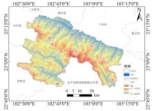
Fig.1
Location and sample distribution in Yuanyang county
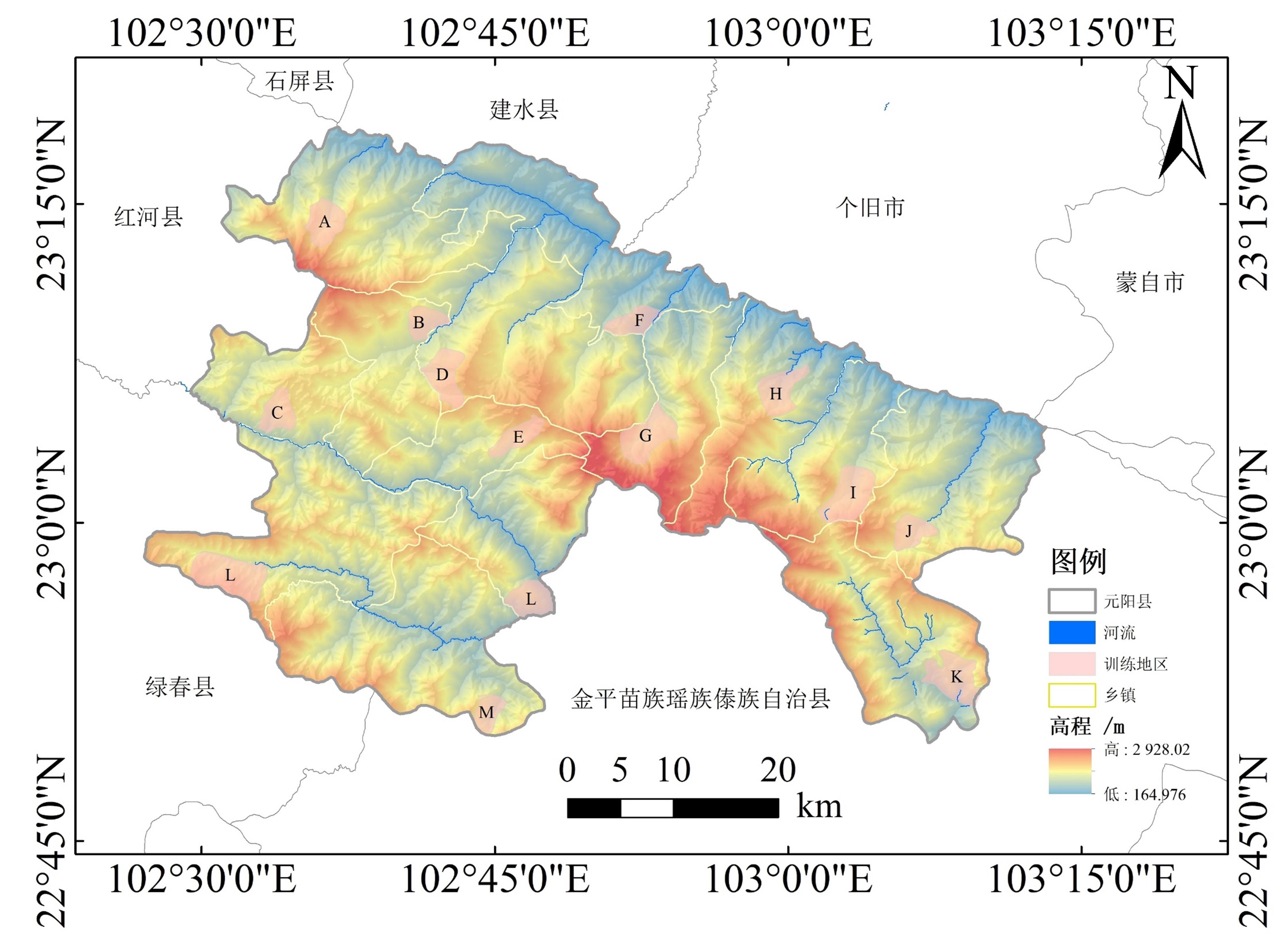
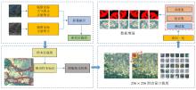
Fig. 2
The process of constructing the terrace identification dataset

Fig. 3
Structure of improved DeepLab V3+

Table 1
The primary parameters of MobileNet v2
| 层 | i | 操作 | c | n | s | r |
|---|---|---|---|---|---|---|
| 1 | – | Conv2d | 32 | 1 | 2 | 1 |
| 2 | 32 | Bottleneck | 16 | 1 | 1 | 1 |
| 3 | 16 | Bottleneck | 24 | 2 | 2 | 1 |
| 4 | 24 | Bottleneck | 32 | 3 | 2 | 1 |
| 5 | 32 | Bottleneck | 64 | 4 | 1 | 1 |
| 6 | 64 | Bottleneck | 96 | 3 | 1 | 1 |
| 7 | 96 | Bottleneck | 160 | 3 | 1 | 4 |
| 8 | 160 | Bottleneck | 320 | 1 | 1 | 1 |
Table 2
The accuracy evaluation metrics and their significance
| 评价指标 | 公式 | 意义 |
|---|---|---|
| 精确率(Precision) | (2) | 衡量模型在预测正类别时的准确性 |
| 召回率(Recall) | (3) | 衡量模型识别所有正类别样本的能力 |
| F 1评分(F 1-Score) | (4) | F 1评分是精确率和召回率的调和平均值,综合考虑模型的准确性和召回能力 |
| 交并比 | (5) | 衡量模型预测的目前区域与实际目标区域之间的重叠程度 |
Table 3
The accuracy comparison of different band combinations in the concentrated terraced area
| 波段组合 | Precision/% | Recall/% | F 1-Score/% | IoU/% | 地块数量 | 预测面积/hm2 |
|---|---|---|---|---|---|---|
| RGB | 90.67 | 86.35 | 88.46 | 79.31 | 790 | 1 015 |
| NirRG | 90.11 | 90.22 | 90.17 | 82.10 | 228 | 964 |
| NirRGB | 89.89 | 90.27 | 90.08 | 80.96 | 326 | 928 |
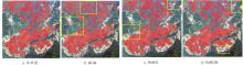
Fig. 4
Extraction results of terraced fields in test areas under different band combinations

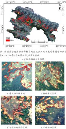
Fig. 5
Results of identification of terraces and typical areas in Yuanyang county

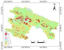
Fig. 6
The spatial distribution of terraced fields in Yuanyang county across different slopes

Table 4
The area and proportion of terraced fields in Yuanyang county at different slope levels
| 坡度/(°) | 面积/hm2 | 占比/% |
|---|---|---|
| <5 | 230.51 | 1.47 |
| 5~8 | 632.32 | 4.05 |
| 8~15 | 5 430.85 | 34.82 |
| 15~25 | 7 820.91 | 50.15 |
| 25~35 | 1 453.59 | 9.32 |
| >35 | 28.75 | 0.18 |
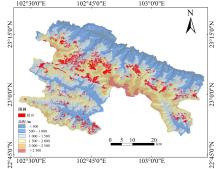
Fig. 7
The spatial distribution of terraced fields in Yuanyang county across different elevations

Table 5
The area and proportion of terraced fields in Yuanyang county at different altitude levels
| 海拔/m | 面积/hm2 | 占比/% |
|---|---|---|
| <500 | N/A | N/A |
| 500~1 000 | 775.72 | 4.98 |
| 1 000~1 500 | 10 825.54 | 69.57 |
| 1 500~2 000 | 3 959.91 | 25.45 |
| 2 000~2 500 | N/A | N/A |
| >2 500 | N/A | N/A |
Table 6
Comparison of the accuracy of the identification results of terraced fields in Yuanyang county
| 方法 | Precision/% | Recall/% | F 1-Score/% | IoU/% |
|---|---|---|---|---|
| PSPNet | 86.21 | 84.07 | 85.21 | 79.20 |
| UNet | 90.44 | 90.49 | 90.46 | 80.41 |
| DeepLab v3+ | 89.31 | 89.47 | 89.39 | 81.12 |
| Improved DeepLab v3+ | 93.93 | 92.08 | 93.17 | 83.93 |
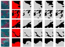
Fig. 8
Comparison of local details in extraction results obtained using different algorithms
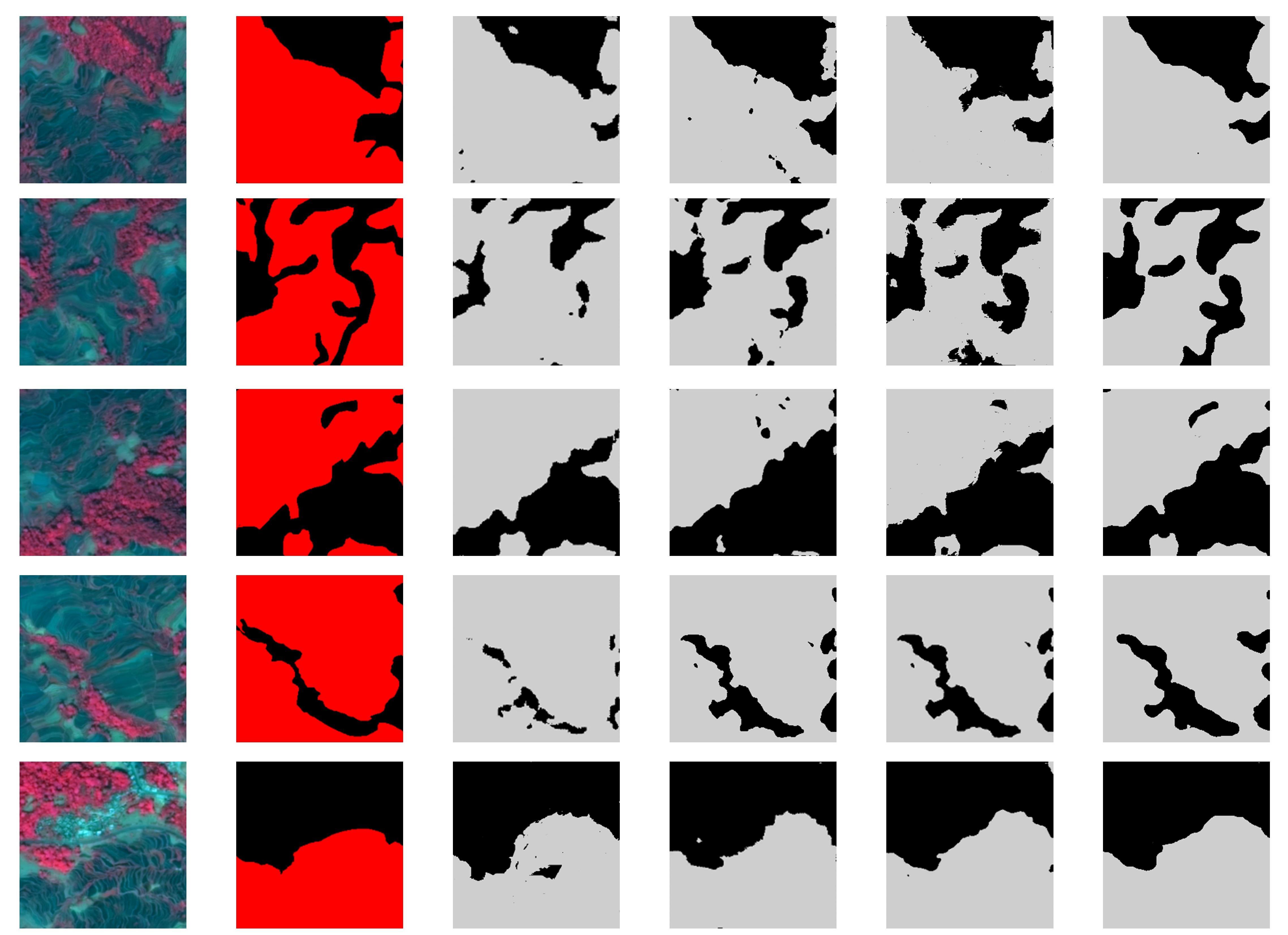
Table 7
Comparison of segmentation efficiency among four algorithms
| 方法 | Parameters/M | FLOPs | OME/epoch |
|---|---|---|---|
| PSPNet | 3 | 8.2×10¹⁰ | 92 |
| UNet | 28 | 1.8×10¹² | 115 |
| DeepLab v3+ | 41 | 1.9×10¹² | 128 |
| Improved DeepLab v3+ | 8 | 3.5×10¹¹ | 108 |
| 1 |
张艳超, 杨海龙, 信忠保, 等. 基于面向对象和无人机影像的黄土高原丘陵区小流域梯田提取研究[J]. 水土保持学报, 2023, 37(3): 139-146.
|
|
|
|
| 2 |
李德仁. 摄影测量与遥感的现状及发展趋势[J]. 武汉测绘科技大学学报, 2000, 25(1): 1-6.
|
|
|
|
| 3 |
张华卫, 张文飞, 蒋占军, 等. 引入上下文信息和Attention Gate的GUS-YOLO遥感目标检测算法[J]. 计算机科学与探索, 2024, 18(2): 453-464.
|
|
|
|
| 4 |
史姝姝, 窦银银, 陈永强, 等. 中国海岸带区域城市扩展遥感监测与内部地表覆盖时空分异特征分析[J]. 自然资源遥感, 2022, 34(4): 76-86.
|
|
|
|
| 5 |
田智慧, 常蓬, 赫晓慧, 等. 一种基于CNN-GCN的高分辨率遥感影像土地覆盖分类[J]. 测绘科学, 2023, 48(6): 59-72.
|
|
|
|
| 6 |
赵钧阳, 赖格英. 高分辨率遥感影像中小尺度梯田纹理信息的增强与提取[J]. 江西科学, 2020, 38(2): 263-268.
|
|
|
|
| 7 |
党恬敏, 穆兴民, 孙文义, 等. 高分辨率遥感影像梯田快速提取方法研究进展[J]. 人民黄河, 2017, 39(3): 85-89, 94.
|
|
|
|
| 8 |
李梦华, 石云, 马永强, 等. 基于面向对象的黄土丘陵沟壑区梯田信息提取研究[J]. 测绘与空间地理信息, 2019, 42(5): 50-54.
|
|
|
|
| 9 |
吴傲, 袁利, 齐斐, 等. 基于随机森林的山丘区梯田措施类型识别与评价[J]. 山东农业大学学报(自然科学版), 2023, 54(4): 582-594.
|
|
|
|
| 10 |
|
| 11 |
|
| 12 |
|
| 13 |
|
| 14 |
刘晓燕, 杨胜天, 王富贵, 等. 黄土高原现状梯田和林草植被的减沙作用分析[J]. 水利学报, 2014, 45(11): 1293-1300.
|
|
|
|
| 15 |
|
| 16 |
|
| 17 |
周珏, 李蒙蒙, 汪小钦, 等. 面向对象卷积神经网络的耕作梯田提取[J]. 遥感信息, 2022, 37(2): 138-144.
|
|
|
|
| 18 |
|
| 19 |
|
| 20 |
刘东杰. 联合波谱和地形特征的深度学习梯田提取方法探讨[D]. 兰州: 兰州大学, 2022.
|
|
|
|
| 21 |
|
| 22 |
刘敬, 刘澄静, 角媛梅, 等. 基于GIS的元阳梯田空间分布及其自然要素分异研究[J]. 水土保持研究, 2020, 27(2): 337-343.
|
|
|
|
| 23 |
|
| 24 |
|
| 25 |
|
| 26 |
|
| 27 |
|
| 28 |
|
| 29 |
|
| 30 |
|
| 31 |
WOO S,
|
| 32 |
|
| 33 |
中华人民共和国水利部. 土壤侵蚀分类分级标准: SL 190—2007 [S]. 北京: 中国水利水电出版社, 2008.
|
|
Ministry of Water Resources of the People's Republic of China. Standards for classification and gradation of soil erosion: SL 190—2007 [S]. Beijing: China water & power press, 2008.
|
|
| 34 |
|
| 35 |
|
| 36 |
|
| [1] | SONG Mingxuan, BAI Bo, YANG Juntao, ZHANG Yutao, LI Sa, LI Zhenhai, WAN Shubo, LI Guowei. Robust UAV-Based Method for Peanut Plant Height Estimation Using Bare-Soil Invariant Constraints [J]. Smart Agriculture, 2025, 7(6): 124-135. |
| [2] | SUN Rong, GAO Han, JIANG Yujie, LI Qiaochu, WU Haoyu, WU Shangrong, YU Shan, XU Lei, YU Liangliang, ZHANG Jie, BAO Yuhai. Progress in Soil Moisture Retrieval under Crop Canopy Cover Based on Multi-polarization SAR Data [J]. Smart Agriculture, 2025, 7(6): 75-95. |
| [3] | ZHANG Yun, ZHANG Lumin, XU Guangtao, HAO Jiahui. Remote Sensing Extraction Method of Rice-Crayfish Fields Based on Dual-Branch and Multi-Scale Attention [J]. Smart Agriculture, 2025, 7(6): 185-195. |
| [4] | LU Yihang, DONG Wen, ZHANG Xin, YAN Ruoyi, ZHANG Yujia, TANG Tao. Physics-Constrained PROSAIL-cGAN Approach for Spectral Sample Augmentation and LAI Inversion of Winter Wheat [J]. Smart Agriculture, 2025, 7(6): 149-160. |
| [5] | WANG Yinhui, ZHAO Anzhou, LI Dan, ZHU Xiufang, ZHAO Jun, WANG Ziqing. Construction and Evaluation of Lightweight and Interpretable Soybean Remote Sensing Identification Model [J]. Smart Agriculture, 2025, 7(6): 136-148. |
| [6] | LONG Yuqiao, SUN Jing, WEN Yanru, WANG Chuya, DONG Xiuchun, HUANG Ping, WU Wenbin, CHEN Jin, DING Mingzhong. Remote Sensing Approaches for Cropland Abandonment Perception in Southern Hilly and Mountainous Areas of China: A Review [J]. Smart Agriculture, 2025, 7(6): 58-74. |
| [7] | XU Jinchai, LI Xiaoli, WENG Haiyong, HE Yong, ZHU Xuesong, LIU Hongfei, HUANG Zhenxiong, YE Dapeng. Rapid Tea Identification and Polyphenol Detection Method in Fresh Tea Leaves Using Visible/Shortwave and Longwave Near-Infrared Spectroscopy [J]. Smart Agriculture, 2025, 7(4): 58-70. |
| [8] | WANG Yi, XUE Rong, HAN Wenting, SHAO Guomin, HOU Yanqiao, CUI Xitong. Estimation of Maize Aboveground Biomass Based on CNN-LSTM-SA [J]. Smart Agriculture, 2025, 7(4): 159-173. |
| [9] | LI Ruijie, WANG Aidong, WU Huaxing, LI Ziqiu, FENG Xiangqian, HONG Weiyuan, TANG Xuejun, QIN Jinhua, WANG Danying, CHU Guang, ZHANG Yunbo, CHEN Song. Remote Sensing for Rice Growth Stages Monitoring: Research Progress, Bottleneck Problems and Technical Optimization Paths [J]. Smart Agriculture, 2025, 7(3): 89-107. |
| [10] | MA Liu, MAO Kebiao, GUO Zhonghua. Defogging Remote Sensing Images Method Based on a Hybrid Attention-Based Generative Adversarial Network [J]. Smart Agriculture, 2025, 7(2): 172-182. |
| [11] | ZHAO Bingting, HUA Chuanhai, YE Chenyang, XIONG Yuchun, QIAN Tao, CHENG Tao, YAO Xia, ZHENG Hengbiao, ZHU Yan, CAO Weixing, JIANG Chongya. Research Progress on Remote Sensing Monitoring and Intelligent Decision-Making Algorithms for Rice Production [J]. Smart Agriculture, 2025, 7(2): 57-72. |
| [12] | E Hailin, ZHOU Decheng, LI Kun. Extracting Method of the Cultivation Aera of Rice Based on Sentinel-1/2 and Google Earth Engine (GEE): A Case Study of the Hangjiahu Plain [J]. Smart Agriculture, 2025, 7(2): 81-94. |
| [13] | LI Minghuang, SU Lide, ZHANG Yong, ZONG Zheying, ZHANG Shun. Automatic Measurement of Mongolian Horse Body Based on Improved YOLOv8n-pose and 3D Point Cloud Analysis [J]. Smart Agriculture, 2024, 6(4): 91-102. |
| [14] | LI Hao, DU Yuqiu, XIAO Xingzhu, CHEN Yanxi. Remote Sensing Identification Method of Cultivated Land at Hill County of Sichuan Basin Based on Deep Learning [J]. Smart Agriculture, 2024, 6(3): 34-45. |
| [15] | QI Jiangtao, CHENG Panting, GAO Fangfang, GUO Li, ZHANG Ruirui. Research Advances and Prospects on Rapid Acquisition Technology of Farmland Soil Physical and Chemical Parameters [J]. Smart Agriculture, 2024, 6(3): 17-33. |
| Viewed | ||||||
|
Full text |
|
|||||
|
Abstract |
|
|||||


