Smart Agriculture ›› 2023, Vol. 5 ›› Issue (3): 75-85.doi: 10.12133/j.smartag.SA202309013
• Special Issue--Monitoring Technology of Crop Information • Previous Articles Next Articles
ZHANG Gan1( ), YAN Haifeng1, HU Gensheng1(), ZHANG Dongyan1,2, CHENG Tao1,2, PAN Zhenggao1,3, XU Haifeng1,3, SHEN Shuhao1,3, ZHU Keyu1
Received:2023-09-11
Online:2023-09-30
Foundation items:University Research Project of Anhui Provincial Department of Education (Natural Science)(2023AH052246); Suzhou University Doctoral Research Foundation(2021BSK043); National Natural Science Foundation of China(42271364)
About author:ZHANG Gan, E-mail:zhanggan@ahu.edu.cn
corresponding author:
HU Gensheng, E-mail:hugs2906@sina.com
ZHANG Gan, YAN Haifeng, HU Gensheng, ZHANG Dongyan, CHENG Tao, PAN Zhenggao, XU Haifeng, SHEN Shuhao, ZHU Keyu. Identification Method of Wheat Field Lodging Area Based on Deep Learning Semantic Segmentation and Transfer Learning[J]. Smart Agriculture, 2023, 5(3): 75-85.
Add to citation manager EndNote|Ris|BibTeX
URL: https://www.smartag.net.cn/EN/10.12133/j.smartag.SA202309013
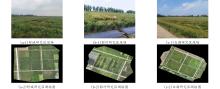
Fig. 1
Site maps and surveying maps of the study areas in Shucheng, Guohe and Baihu
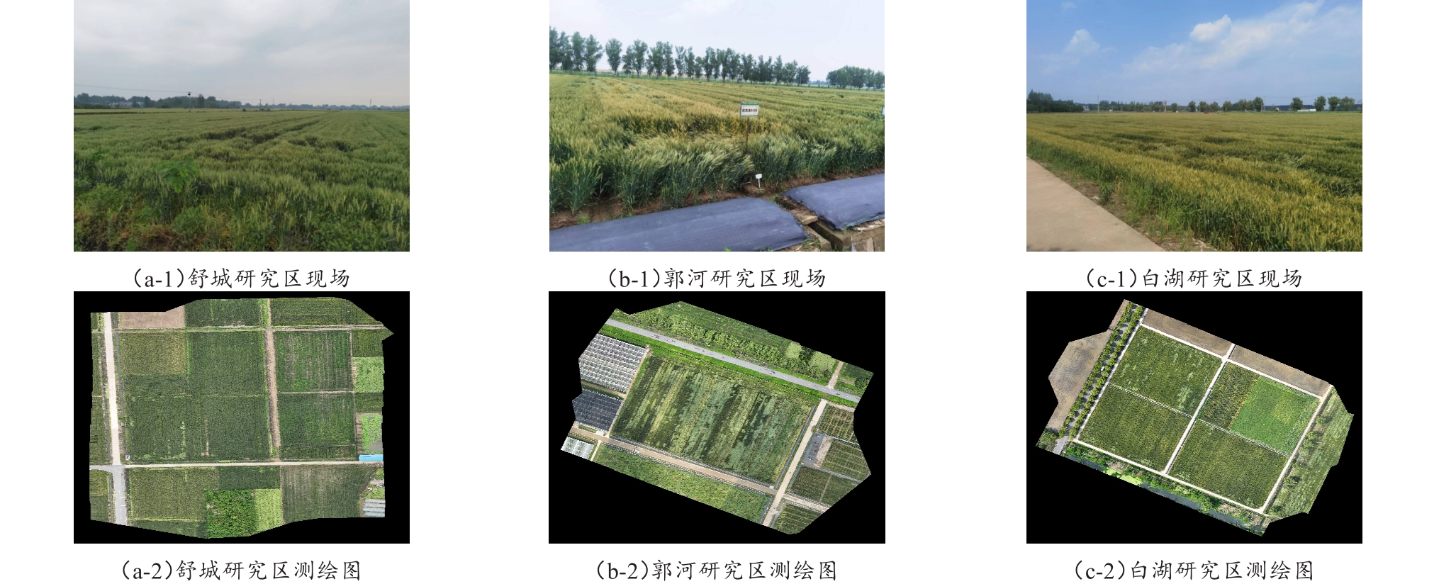
Fig. 2
Wheat lodging during the filling and mature period
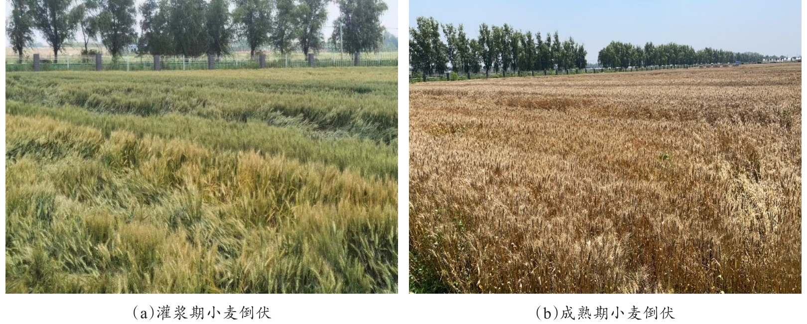
Table1
Statistics information of wheat fields of the study areas in Shucheng, Guohe and Baihu
| 研究区 | 年份 | 作业面积/m2 | 图像采集天数/d | 拼接图像数量/张 | 倒伏面积占比/% | |
|---|---|---|---|---|---|---|
| 40 m飞行高度 | 80 m飞行高度 | |||||
| 舒城 | 2023 | 33,041.5 | 5 | 5 | 5 | 13.84 |
| 郭河 | 2020 | 13,521.2 | 3 | 3 | —— | 19.81 |
| 2021 | 13,446.4 | 4 | 4 | 3 | 28.11 | |
| 2023 | 13,907.4 | 5 | 5 | 5 | 64.99 | |
| 白湖 | 2019 | 28,451.2 | 4 | 4 | 1 | 6.52 |
| 2020 | 28,553.4 | 2 | 3 | —— | 14.81 | |
| 2021 | 28,556.3 | 3 | 3 | 3 | 11.61 | |
| 2023 | 28,573.7 | 5 | 5 | 5 | 17.93 | |
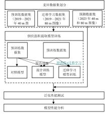
Fig. 3
Technical route for wheat lodging areas detection based on transfer learning
Table 2
Confusion matrix
| 混淆矩阵 | 图像标注结果 | ||
|---|---|---|---|
| 倒伏 | 非倒伏 | ||
| 图像分割结果 | 倒伏 | TP | FP |
| 非倒伏 | FN | TN | |
Table 3
Accuracy and speed for lodging area detection of the study areas in Shucheng, Guohe and Baihu
| 模型 | 飞行高度/m | 研究区 | 交并比/% | 正确率/% | 精确率/% | 召回率/% | F 1-Score/% | 算法速度/(f·s-1) |
|---|---|---|---|---|---|---|---|---|
| 对照模型 | 40 | 舒城 | 86.78 | 97.21 | 90.80 | 94.65 | 92.61 | 0.0055 |
| 郭河 | 81.03 | 90.15 | 89.15 | 89.81 | 89.45 | 0.0122 | ||
| 白湖 | 90.47 | 97.19 | 94.40 | 95.38 | 94.88 | 0.0064 | ||
| 80 | 舒城 | 82.40 | 96.53 | 90.20 | 89.24 | 89.72 | 0.0228 | |
| 郭河 | 75.40 | 86.68 | 85.02 | 88.69 | 85.88 | 0.0504 | ||
| 白湖 | 88.74 | 96.70 | 95.43 | 92.47 | 93.87 | 0.0265 | ||
| 混合训练模型 | 40 | 舒城 | 84.34 | 96.45 | 87.75 | 95.32 | 91.06 | 0.0053 |
| 郭河 | 80.11 | 89.84 | 89.52 | 88.33 | 88.86 | 0.0118 | ||
| 白湖 | 88.64 | 96.47 | 91.76 | 96.28 | 93.82 | 0.0061 | ||
| 80 | 舒城 | 84.35 | 96.79 | 89.29 | 93.00 | 91.04 | 0.0231 | |
| 郭河 | 81.84 | 90.75 | 88.95 | 91.53 | 89.94 | 0.0525 | ||
| 白湖 | 89.61 | 96.94 | 95.34 | 93.50 | 94.39 | 0.0267 | ||
| 迁移学习模型 | 40 | 舒城 | 84.29 | 96.40 | 87.42 | 95.80 | 91.03 | 0.0057 |
| 郭河 | 81.16 | 90.49 | 90.56 | 88.72 | 89.51 | 0.0124 | ||
| 白湖 | 88.36 | 96.36 | 91.48 | 96.30 | 93.66 | 0.0066 | ||
| 80 | 舒城 | 83.72 | 96.68 | 89.33 | 92.03 | 90.62 | 0.0227 | |
| 郭河 | 82.71 | 91.32 | 89.66 | 91.56 | 90.46 | 0.0511 | ||
| 白湖 | 89.68 | 96.93 | 94.90 | 93.97 | 94.43 | 0.0264 |
Table 4
Mean weighted frame rate of each model of the study areas in Shucheng, Guohe and Baihu
| 模型 | 飞行高度/m | 平均加权帧率/(fps·m-2) |
|---|---|---|
| 对照模型 | 40 | 178.09 |
| 80 | 737.16 | |
| 混合训练模型 | 40 | 171.18 |
| 80 | 752.10 | |
| 迁移学习模型 | 40 | 183.12 |
| 80 | 738.35 |
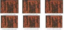
Fig. 4
Example of wheatland lodging area detection

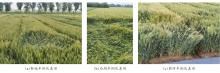
Fig. 5
Semi lodging wheat in the study areas of Shucheng, Baihu and Guohe

| 1 |
中华人民共和国国家统计局. 国家数据[EB/OL]. (2021-12-06)[2023-01-29].
|
| 2 |
|
|
|
|
| 3 |
|
| 4 |
|
| 5 |
韩东, 杨浩, 杨贵军, 等. 基于Sentinel-1雷达影像的玉米倒伏监测模型[J]. 农业工程学报, 2018, 34(3): 166-172.
|
|
|
|
| 6 |
|
| 7 |
|
| 8 |
|
| 9 |
李宗南, 陈仲新, 任国业, 等. 基于Worldview-2影像的玉米倒伏面积估算[J]. 农业工程学报, 2016, 32(2): 1-5.
|
|
|
|
| 10 |
|
| 11 |
|
| 12 |
|
| 13 |
|
| 14 |
|
| 15 |
|
| 16 |
|
| 17 |
|
| 18 |
|
| 19 |
|
| 20 |
|
| 21 |
|
| 22 |
|
| 23 |
|
| 24 |
|
| 25 |
|
| 26 |
|
| 27 |
|
| 28 |
|
| 29 |
|
| 30 |
|
| 31 |
|
| [1] | HU Yumeng, GUAN Feifan, XIE Dongchen, MA Ping, YU Youben, ZHOU Jie, NIE Yanming, HUANG Lüwen. Tea Leaf Disease Diagnosis Based on Improved Lightweight U-Net3+ [J]. Smart Agriculture, 2026, 8(1): 15-27. |
| [2] | SUN Rong, GAO Han, JIANG Yujie, LI Qiaochu, WU Haoyu, WU Shangrong, YU Shan, XU Lei, YU Liangliang, ZHANG Jie, BAO Yuhai. Progress in Soil Moisture Retrieval under Crop Canopy Cover Based on Multi-polarization SAR Data [J]. Smart Agriculture, 2025, 7(6): 75-95. |
| [3] | ZHANG Yun, ZHANG Lumin, XU Guangtao, HAO Jiahui. Remote Sensing Extraction Method of Rice-Crayfish Fields Based on Dual-Branch and Multi-Scale Attention [J]. Smart Agriculture, 2025, 7(6): 185-195. |
| [4] | XU Wenwen, YU Kejian, DAI Zexu, WU Yunzhi. A Transfer Learning-Based Multimodal Model for Grape Detection and Counting [J]. Smart Agriculture, 2025, 7(4): 174-186. |
| [5] | HU Lingyan, GUO Ruiya, GUO Zhanjun, XU Guohui, GAI Rongli, WANG Zumin, ZHANG Yumeng, JU Bowen, NIE Xiaoyu. U-Net Greenhouse Sweet Cherry Image Segmentation Method Integrating PDE Plant Temporal Image Contrastive Learning and GCN Skip Connections [J]. Smart Agriculture, 2025, 7(3): 131-142. |
| [6] | JIN Ning, GUO Yufeng, HAN Xiaodong, MIAO Yisheng, WU Huarui. Method for Calculating Semantic Similarity of Short Agricultural Texts Based on Transfer Learning [J]. Smart Agriculture, 2025, 7(1): 33-43. |
| [7] | YAN Congkuan, ZHU Dequan, MENG Fankai, YANG Yuqing, TANG Qixing, ZHANG Aifang, LIAO Juan. Rice Leaf Disease Image Enhancement Based on Improved CycleGAN [J]. Smart Agriculture, 2024, 6(6): 96-108. |
| [8] | FAN Mingshuo, ZHOU Ping, LI Miao, LI Hualong, LIU Xianwang, MA Zhirun. Automatic Navigation and Spraying Robot in Sheep Farm [J]. Smart Agriculture, 2024, 6(4): 103-115. |
| [9] | ZHU Yiping, WU Huarui, GUO Wang, WU Xiaoyan. Identification Method of Kale Leaf Ball Based on Improved UperNet [J]. Smart Agriculture, 2024, 6(3): 128-137. |
| [10] | PANG Chunhui, CHEN Peng, XIA Yi, ZHANG Jun, WANG Bing, ZOU Yan, CHEN Tianjiao, KANG Chenrui, LIANG Dong. HI-FPN: A Hierarchical Interactive Feature Pyramid Network for Accurate Wheat Lodging Localization Across Multiple Growth Periods [J]. Smart Agriculture, 2024, 6(2): 128-139. |
| [11] | TANG Hui, WANG Ming, YU Qiushi, ZHANG Jiaxi, LIU Liantao, WANG Nan. Root Image Segmentation Method Based on Improved UNet and Transfer Learning [J]. Smart Agriculture, 2023, 5(3): 96-109. |
| [12] | PAN Weiting, SUN Mengli, YUN Yan, LIU Ping. Identification Method of Wheat Grain Phenotype Based on Deep Learning of ImCascade R-CNN [J]. Smart Agriculture, 2023, 5(3): 110-120. |
| [13] | WANG Yapeng, CAO Shanshan, LI Quansheng, SUN Wei. Desert Plant Recognition Method Under Natural Background Incorporating Transfer Learning and Ensemble Learning [J]. Smart Agriculture, 2023, 5(2): 93-103. |
| [14] | ZHU Haipeng, ZHANG Yu'an, LI Huanhuan, WANG Jianwen, YANG Yingkui, SONG Rende. Classification and Recognition Method for Yak Meat Parts Based on Improved Residual Network Model [J]. Smart Agriculture, 2023, 5(2): 115-125. |
| [15] | PAN Chenlu, ZHANG Zhenghua, GUI Wenhao, MA Jiajun, YAN Chenxi, ZHANG Xiaomin. Rice Disease and Pest Recognition Method Integrating ECA Mechanism and DenseNet201 [J]. Smart Agriculture, 2023, 5(2): 45-55. |
| Viewed | ||||||
|
Full text |
|
|||||
|
Abstract |
|
|||||


