Smart Agriculture ›› 2025, Vol. 7 ›› Issue (6): 174-184.doi: 10.12133/j.smartag.SA202508024
• Special Issue--Remote Sensing + AI Empowering the Modernization of Agriculture and Rural Areas • Previous Articles Next Articles
ZHANG Yunxiang, WU Xuequn( ), HE Yonglin, MA Junwei
Received:2025-08-26
Online:2025-11-30
Foundation items:National Natural Science Foundation of China(42261074,42464001)
About author:ZHANG Yunxiang, E-mail: zhangyunxiang2@stu.kust.edu.cn
corresponding author:
CLC Number:
ZHANG Yunxiang, WU Xuequn, HE Yonglin, MA Junwei. Remote Sensing Monitoring Method of Cropping Index in Typical Open-Field Vegetable Production Areas[J]. Smart Agriculture, 2025, 7(6): 174-184.
Add to citation manager EndNote|Ris|BibTeX
URL: https://www.smartag.net.cn/EN/10.12133/j.smartag.SA202508024
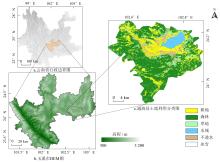
Fig. 1
The area map of Tonghai, Yuxi city, Yunnan province


Fig. 2
Distribution of valid Sentinel-2 observations from 2020 to 2024

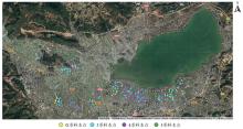
Fig. 3
Distribution of ground survey sample points in Tonghai county

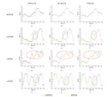
Fig. 4
Reconstructed NDVI time-series curves under different cropping systems
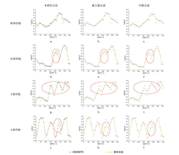
Table 1
Accuracy validation results of cropping index extraction in Tonghai county
| 种植制度 | 单季 | 双季 | 3季 | 4季 | 5季 | 生产者精度/% |
|---|---|---|---|---|---|---|
| 总体精度(OA) | 89.94%, | Kappa系数 | 0.835 | |||
| 单季 | 0 | 0 | 0 | 0 | 0 | / |
| 双季 | 1 | 33 | 1 | 0 | 0 | 94.29 |
| 3季 | 0 | 3 | 140 | 6 | 0 | 93.96 |
| 4季 | 0 | 3 | 16 | 126 | 1 | 86.30 |
| 5季 | 0 | 0 | 0 | 3 | 5 | 62.50 |
| 用户精度/% | / | 84.62 | 89.17 | 93.33 | 83.33 | / |
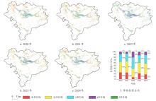
Fig. 5
Spatial distribution of cropping index in Tonghai County from 2020 to 2024

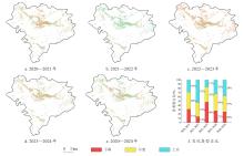
Fig. 6
Interannual spatial distribution of cropping index in Tonghai County from 2020 to 2024

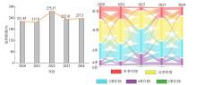
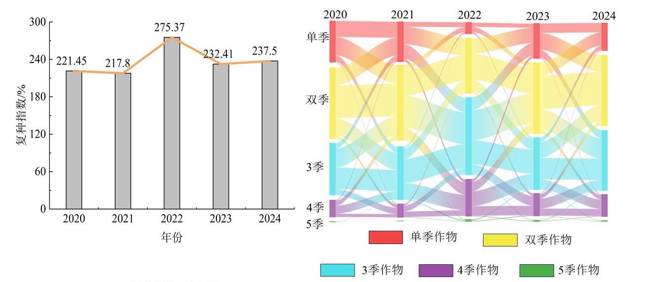
Fig. 7
Land use transition of different cropping systems in Tonghai County from 2020 to 2024
| [1] |
|
| [2] |
陈仲新, 郝鹏宇, 刘佳, 等. 农业遥感卫星发展现状及我国监测需求分析[J]. 智慧农业, 2019, 1(1): 32-42.
|
|
|
|
| [3] |
|
| [4] |
|
| [5] |
|
| [6] |
|
| [7] |
|
| [8] |
|
| [9] |
李卓, 刘淑亮, 孙然好, 等. 黄淮海地区耕地复种指数的时空格局演变[J]. 生态学报, 2018, 38(12): 4454-4460.
|
|
|
|
| [10] |
|
| [11] |
|
| [12] |
|
| [13] |
李宇, 邱炳文, 何玉花, 等. 基于MODIS数据的2001—2018年中国耕地复种指数反演研究[J]. 地理科学进展, 2020, 39(11): 1874-1883.
|
|
|
|
| [14] |
|
| [15] |
|
| [16] |
许利洋. 2000—2018年江汉平原耕地复种时空格局变化及其驱动机制研究[D]. 武汉: 华中师范大学, 2020.
|
|
|
|
| [17] |
|
| [18] |
|
| [19] |
|
| [20] |
葛中曦, 黄静, 赖佩玉, 等. 耕地复种指数遥感监测研究进展[J]. 地球信息科学学报, 2021, 23(7): 1169-1184.
|
|
|
|
| [21] |
鄂海林, 周德成, 李坤. 基于Sentinel 1/2和GEE的水稻种植面积提取方法: 以杭嘉湖平原为例[J]. 智慧农业(中英文), 2025, 7(2): 81-94.
|
|
|
|
| [22] |
|
| [23] |
通海县人民政府. 走进通海[EB/OL]. 通海县人民政府门户网站, 综合发布于2024—2025年. [2025-11-08].
|
|
Tonghai County People's Government. Explore Tonghai [EB/OL]. Tonghai County People's Government Portal, publishedbetween 2024 and 2025 [2025-11-08].
|
|
| [24] |
|
| [25] |
|
| [26] |
|
| [27] |
|
| [28] |
|
| [29] |
郭佳炜, 叶回春, 聂超甲, 等. 基于Sentinel-2的海南耕地复种指数监测及时空变化分析[J]. 遥感技术与应用, 2022, 37(5): 1128-1139.
|
|
|
|
| [30] |
申健, 常庆瑞, 李粉玲, 等. 2000—2013年关中地区耕地复种指数遥感动态监测[J]. 农业机械学报, 2016, 47(8): 280-287.
|
|
|
|
| [31] |
|
| [1] | XU Xiaobin, ZHU Hongchun, LI Feng, HE Wei, YANG Jiaming, LI Zhenhai. High Spatiotemporal Resolution Remote Sensing for Precision Agricultural Disaster Early Warning: Progress, Bottlenecks, and Integrative Pathways [J]. Smart Agriculture, 2026, (): 1-17. |
| [2] | WU Chenxu, ZUO Haolong, LI Gang. Multi-Source Remote Sensing Crop Classification Via Cross-Modal Attention [J]. Smart Agriculture, 2026, (): 1-15. |
| [3] | LIU Enqi, LIU Miao, WANG Tuo, ZHU Yaohui, CHEN Riqiang, XU Bo, GAO Meiling, ZHANG Jing, YANG Yun, YANG Guijun. A Bi-LSTM Prediction Method for Apple First Flowering Date Based on Enhanced Time-Series Temperature Features [J]. Smart Agriculture, 2026, (): 1-12. |
| [4] | LONG Yuqiao, SUN Jing, WEN Yanru, WANG Chuya, DONG Xiuchun, HUANG Ping, WU Wenbin, CHEN Jin, DING Mingzhong. Remote Sensing Approaches for Cropland Abandonment Perception in Southern Hilly and Mountainous Areas of China: A Review [J]. Smart Agriculture, 2025, 7(6): 58-74. |
| [5] | LU Yihang, DONG Wen, ZHANG Xin, YAN Ruoyi, ZHANG Yujia, TANG Tao. Physics-Constrained PROSAIL-cGAN Approach for Spectral Sample Augmentation and LAI Inversion of Winter Wheat [J]. Smart Agriculture, 2025, 7(6): 149-160. |
| [6] | XIE Wenhao, ZHANG Xin, DONG Wen, ZHENG Yizhen, CHENG Bo, TU Wenli, SUN Fengqing. Parcel-Scale Crop Distribution Mapping Based on Stacking Ensemble Learning [J]. Smart Agriculture, 2025, 7(6): 196-209. |
| [7] | ZHANG Yun, ZHANG Lumin, XU Guangtao, HAO Jiahui. Remote Sensing Extraction Method of Rice-Crayfish Fields Based on Dual-Branch and Multi-Scale Attention [J]. Smart Agriculture, 2025, 7(6): 185-195. |
| [8] | SUN Rong, GAO Han, JIANG Yujie, LI Qiaochu, WU Haoyu, WU Shangrong, YU Shan, XU Lei, YU Liangliang, ZHANG Jie, BAO Yuhai. Progress in Soil Moisture Retrieval under Crop Canopy Cover Based on Multi-polarization SAR Data [J]. Smart Agriculture, 2025, 7(6): 75-95. |
| [9] | SONG Mingxuan, BAI Bo, YANG Juntao, ZHANG Yutao, LI Sa, LI Zhenhai, WAN Shubo, LI Guowei. Robust UAV-Based Method for Peanut Plant Height Estimation Using Bare-Soil Invariant Constraints [J]. Smart Agriculture, 2025, 7(6): 124-135. |
| [10] | YAO Jianen, LIU Haiqiu, YANG Man, FENG Jinying, CHEN Xiu, ZHANG Peipei. Reconstruction of U.S. Regional-Scale Soybean SIF Based on MODIS Data and BP Neural Network [J]. Smart Agriculture, 2024, 6(5): 40-50. |
| [11] | FU Hongyu, WANG Wei, LIAO Ao, YUE Yunkai, XU Mingzhi, WANG Ziwei, CHEN Jianfu, SHE Wei, CUI Guoxian. High Quality Ramie Resource Screening Based on UAV Remote Sensing Phenotype Monitoring [J]. Smart Agriculture, 2022, 4(4): 74-83. |
| [12] | FAN Chengzhi, WANG Ziwen, YANG Xingchao, LUO Yongkai, XU Xuexin, GUO Bin, LI Zhenhai. Machine Learning Inversion Model of Soil Salinity in the Yellow River Delta Based on Field Hyperspectral and UAV Multispectral Data [J]. Smart Agriculture, 2022, 4(4): 61-73. |
| [13] | WANG Lin, LIANG Jian, MENG Fanyu, MENG Yang, ZHANG Yongtao, LI Zhenhai. Estimating Grain Protein Content of Winter Wheat in Producing Areas Based on Remote Sensing and Meteorological Data [J]. Smart Agriculture, 2021, 3(2): 15-22. |
| [14] | YANG Feifei, LIU Shengping, ZHU Yeping, LI Shijuan. Identification and Level Discrimination of Waterlogging Stress in Winter Wheat Using Hyperspectral Remote Sensing [J]. Smart Agriculture, 2021, 3(2): 35-44. |
| [15] | DAI Shengpei, LUO Hongxia, ZHENG Qian, HU Yingying, LI Hailiang, LI Maofen, YU Xuan, CHEN Bangqian. Comparison of Remote Sensing Estimation Models for Leaf Area Index of Rubber Plantation in Hainan Island [J]. Smart Agriculture, 2021, 3(2): 45-54. |
| Viewed | ||||||
|
Full text |
|
|||||
|
Abstract |
|
|||||


