Smart Agriculture ›› 2025, Vol. 7 ›› Issue (6): 58-74.doi: 10.12133/j.smartag.SA202505022
• Special Issue--Remote Sensing + AI Empowering the Modernization of Agriculture and Rural Areas • Previous Articles Next Articles
LONG Yuqiao1, SUN Jing2, WEN Yanru2, WANG Chuya1, DONG Xiuchun1, HUANG Ping1, WU Wenbin2, CHEN Jin3, DING Mingzhong4( )
)
Received:2025-05-22
Online:2025-11-30
Foundation items:National Key Research and Development Project of China(2022YFD2001105); Key Research and Development Project of the Tibet Autonomous Region Science and Technology Program(XZ202201ZY0008N); Sichuan Provincial Financial Independent Innovation Project(2022ZZCX031)
About author:LONG Yuqiao, E-mail: longyuqiao_irsa@scsaas.cn
corresponding author:
CLC Number:
LONG Yuqiao, SUN Jing, WEN Yanru, WANG Chuya, DONG Xiuchun, HUANG Ping, WU Wenbin, CHEN Jin, DING Mingzhong. Remote Sensing Approaches for Cropland Abandonment Perception in Southern Hilly and Mountainous Areas of China: A Review[J]. Smart Agriculture, 2025, 7(6): 58-74.
Add to citation manager EndNote|Ris|BibTeX
URL: https://www.smartag.net.cn/EN/10.12133/j.smartag.SA202505022
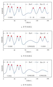
Fig. 1
Schematic diagram of vegetation index time-series curve characteristics for different abandonment types
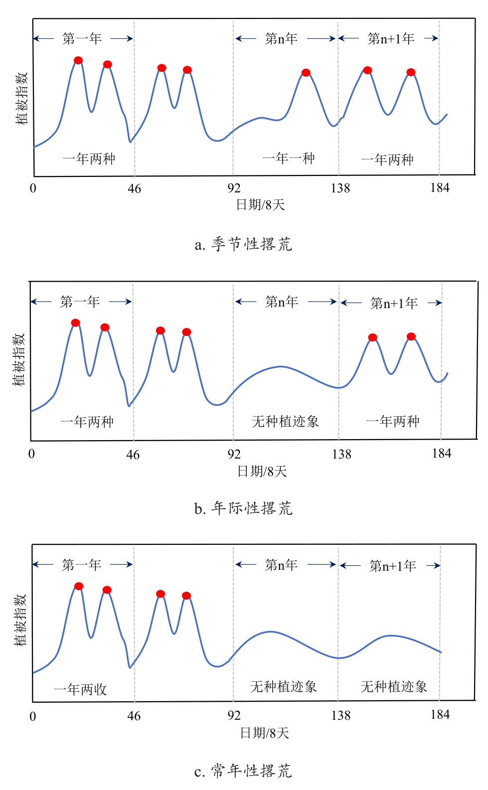
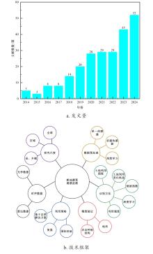
Fig. 2
Number of publications on spatiotemporal pattern perception methods for cropland abandonment in southern hilly and mountainous regions of China

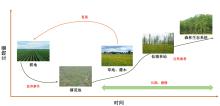
Fig. 3
The complex process of explicit cropland abandonment in the southern hilly and mountainous regions of China
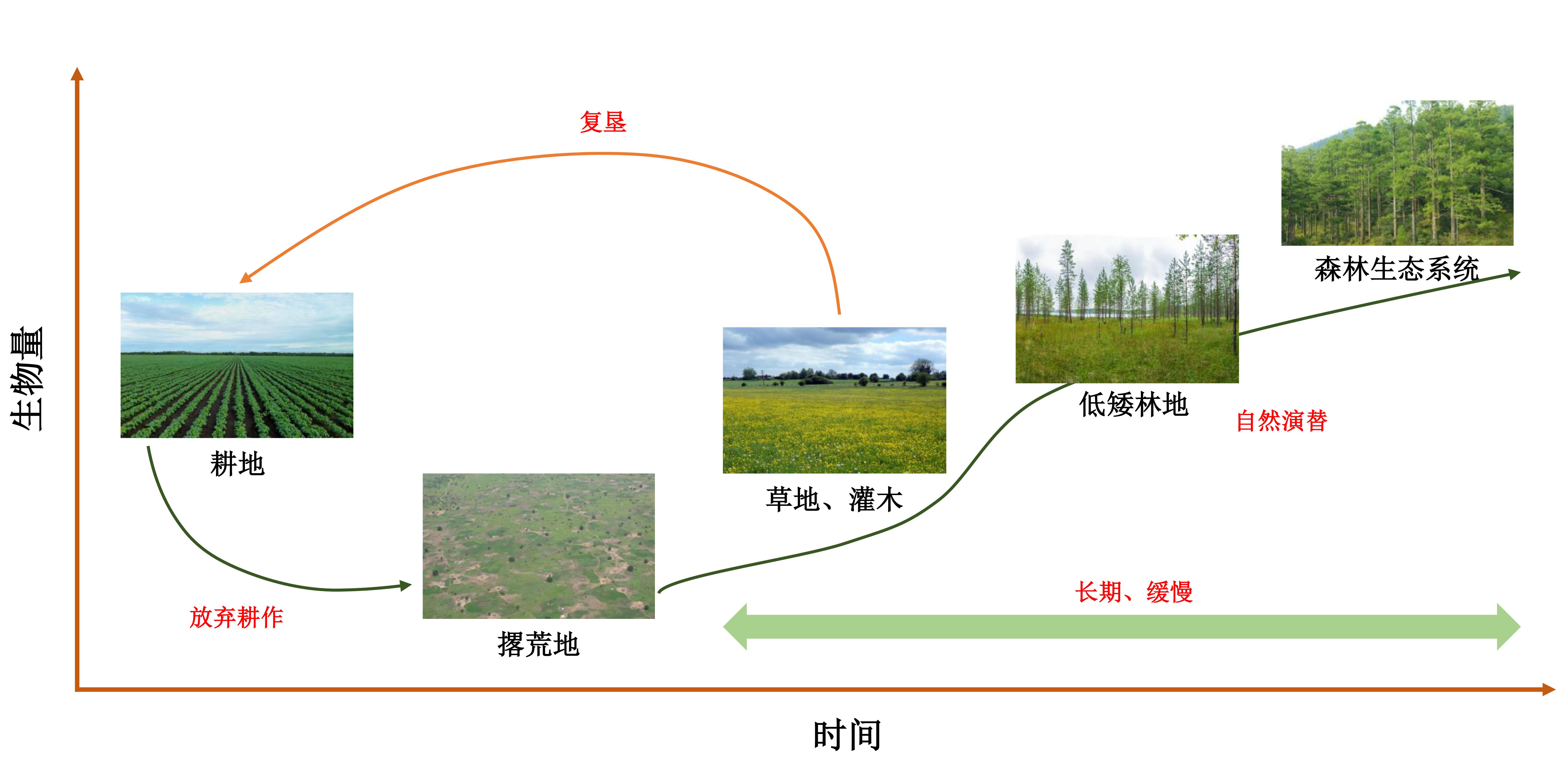
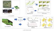
Fig. 4
Schematic diagram of cropland abandonment detection using remote sensing techniques

Table 1
Remote sensing based monitoring strategies for cropland abandonment in different environments in southern hilly and mountainous areas
| 环境特征 | 数据源 | 识别算法 | 精度 | 优势与局限性 | 参考文献 |
|---|---|---|---|---|---|
| 大尺度、地形相对平缓 | MODIS | 随机森林 | 82%以上 | 优势:覆盖范围广,时间序列长,利于宏观趋势分析 局限性:空间分辨率低,无法识别破碎地块,易受混合像元影响 | [ |
| 决策树 | 85%以上 | [ | |||
| / | 83% | [ | |||
| 中尺度、中等破碎丘陵 | Landsat | 随机森林 | 75%~86% | 优势:时间序列长,历史追溯性强,适合监测长期显性撂荒 局限性:重访周期长,易受云雨影响,对多熟制下的季节性撂荒识别困难 | [ |
| 决策树 | 75%~87% | [ | |||
| Sentinel-2 | 决策树 | 90% | [ | ||
| 支持向量机 | 65% | [ | |||
| Sentinel-1 | 深度学习 | 79%以上 | [ | ||
| Landsat+Sentinel-2 | 支持向量机 | 95% | [ | ||
| 决策树 | 84% | [ | |||
| Landsat+Sentinel-2+ Sentinel-1(SAR) | 随机森林 | 89% | [ | ||
| 小尺度、地块级精细监测 | Sentinel-1 | / | 80% | 优势:空间分辨率极高,可识别田埂、耕作痕迹等微观特征 局限性:数据获取成本高,覆盖范围小,难以进行大范围、长时序监测 | [ |
| UAV | 分形维数 | / | [ |
| [1] |
|
| [2] |
|
| [3] |
|
| [4] |
|
| [5] |
|
| [6] |
|
| [7] |
邓利梅, 陆传豪, 刘刚才. 川中丘陵区耕地撂荒对土壤肥力的影响[J]. 西南大学学报(自然科学版), 2021, 43(3): 36-44.
|
|
|
|
| [8] |
杨通, 郭旭东, 于潇, 等. 撂荒地监测方法与生态影响述评[J]. 生态环境学报, 2020, 29(8): 1683-1692.
|
|
|
|
| [9] |
|
| [10] |
|
| [11] |
王刚, 廖和平, 温涛. 重庆南川村域耕地撂荒成因及分异机制与调控[J]. 地理学报, 2024, 79(7): 1824-1841.
|
|
|
|
| [12] |
|
| [13] |
|
| [14] |
|
| [15] |
|
| [16] |
陈航, 谭永忠, 邓欣雨, 等. 撂荒耕地信息获取方法研究进展与展望[J]. 农业工程学报, 2020, 36(23): 258-268.
|
|
|
|
| [17] |
罗雅红, 龚建周, 李天翔, 等. 基于MaxEnt模型提取撂荒耕地: 以四川省武胜县为例[J]. 农业资源与环境学报, 2021, 38(6): 1084-1093.
|
|
|
|
| [18] |
杨国永, 许文兴. 耕地抛荒及其治理: 文献述评与研究展望[J]. 中国农业大学学报, 2015, 20(5): 279-288.
|
|
|
|
| [19] |
李升发, 李秀彬. 中国山区耕地利用边际化表现及其机理[J]. 地理学报, 2018, 73(5): 803-817.
|
|
|
|
| [20] |
李升发, 李秀彬. 耕地撂荒研究进展与展望[J]. 地理学报, 2016, 71(3): 370-389.
|
|
|
|
| [21] |
谭术魁. 耕地撂荒程度描述、可持续性评判指标体系及其模式[J]. 中国土地科学, 2003, 17(6): 3-8.
|
|
|
|
| [22] |
|
| [23] |
|
| [24] |
|
| [25] |
|
| [26] |
|
| [27] |
张天柱, 张凤荣, 黄敬文, 等. 工业化区域撂荒耕地空间格局演变及影响因素分析[J]. 农业工程学报, 2019, 35(15): 246-255.
|
|
|
|
| [28] |
|
| [29] |
|
| [30] |
|
| [31] |
|
| [32] |
|
| [33] |
|
| [34] |
|
| [35] |
|
| [36] |
|
| [37] |
|
| [38] |
|
| [39] |
|
| [40] |
|
| [41] |
|
| [42] |
|
| [43] |
|
| [44] |
|
| [45] |
|
| [46] |
|
| [47] |
|
| [48] |
|
| [49] |
|
| [50] |
|
| [51] |
|
| [52] |
|
| [53] |
|
| [54] |
|
| [55] |
|
| [56] |
|
| [57] |
|
| [58] |
|
| [59] |
温泉, 李璐, 熊立, 等. 基于深度学习的遥感图像水体提取综述[J]. 自然资源遥感, 2024, 36(3): 57-71.
|
|
|
|
| [60] |
|
| [61] |
|
| [62] |
|
| [63] |
|
| [64] |
|
| [65] |
万军. 贵州省喀斯特地区土地退化与生态重建研究进展[J]. 地球科学进展, 2003, 18(3): 447-453.
|
|
|
|
| [66] |
祝小科, 朱守谦. 喀斯特石质山地封山育林效果分析[J]. 林业科技, 2001, 26(6): 1-4.
|
|
|
|
| [67] |
李雨凌, 马雯秋, 姜广辉, 等. 中国粮食主产区耕地撂荒程度及其对粮食产量的影响[J]. 自然资源学报, 2021, 36(6): 1439-1454.
|
|
|
|
| [68] |
|
| [69] |
陈宁强, 戴锦芳. 人机交互式土地资源遥感解译方法研究[J]. 遥感技术与应用, 1998, 13(2): 15-20.
|
|
|
|
| [70] |
李阳兵, 罗光杰, 黄娟. 茂兰喀斯特自然保护区撂荒地时空演变、机制及其植被恢复[J]. 中国岩溶, 2017, 36(4): 447-453.
|
|
|
|
| [71] |
郑财贵, 邱道持, 叶公强, 等. 基于GIS空间分析的撂荒地空间分布特征研究: 以重庆市璧山县大路镇为例[J]. 农机化研究, 2010, 32(3): 31-36.
|
|
|
|
| [72] |
程宪波, 高根红, 刘琼, 等. 快速城镇化地区的耕地撂荒空间格局、影响机理与治理路径[J]. 农业工程学报, 2022, 38(24): 218-227.
|
|
|
|
| [73] |
林妙萍, 杨颖频, 吴志峰, 等. 基于M-TWDTW模型的粤北山区耕地撂荒遥感监测研究[J]. 地理空间信息, 2023, 21(12): 29-34.
|
|
|
|
| [74] |
王圆圆, 李京. 遥感影像土地利用/覆盖分类方法研究综述[J]. 遥感信息, 2004, 19(1): 53-59.
|
|
|
|
| [75] |
|
| [76] |
|
| [77] |
|
| [78] |
|
| [79] |
|
| [80] |
|
| [81] |
|
| [82] |
|
| [83] |
范德芹, 赵学胜, 朱文泉, 等. 植物物候遥感监测精度影响因素研究综述[J]. 地理科学进展, 2016, 35(3): 304-319.
|
|
|
|
| [84] |
|
| [85] |
|
| [86] |
|
| [87] |
|
| [88] |
宋宪强, 梁钊雄, 周红艺, 等. 基于决策树与时序NDVI变化检测的耕地撂荒遥感监测: 以四川省凉山州普格县为例[J]. 山地学报, 2021, 39(6): 912-921.
|
|
|
|
| [89] |
|
| [90] |
|
| [91] |
王佑汉, 李谦, 曾琨. 基于分形理论的撂荒耕地和未撂荒耕地空间分布研究[J]. 中国农业信息, 2020, 32(2): 56-64.
|
|
|
|
| [92] |
陶建斌, 王昀, 张馨月, 等. 基于物候信息图谱的耕地种植模式遥感监测方法[J]. 中国农业科学, 2024, 57(4): 663-678.
|
|
|
|
| [93] |
|
| [94] |
夏玉松, 周启刚, 李辉, 等. 基于决策树与NDVI时序变化检测的撂荒耕地的地形特征研究: 以重庆市巫山县为例[J]. 水土保持通报, 2024, 44(4): 383-393.
|
|
|
|
| [95] |
|
| [96] |
郝心怡, 张江, 白瑞, 等. 长江中下游地区耕地复种指数时空特征及驱动机制研究[J]. 国土资源科技管理, 2021, 38(4): 15-27.
|
|
|
|
| [97] |
张闯娟, 何洪鸣. 西南地区耕地复种指数的时空格局演变及影响因素[J]. 干旱地区农业研究, 2020, 38(3): 222-230.
|
|
|
|
| [98] |
|
| [99] |
辛良杰, 李秀彬. 近年来我国南方双季稻区复种的变化及其政策启示[J]. 自然资源学报, 2009, 24(1): 58-65.
|
|
|
|
| [100] |
|
| [101] |
冀咏赞, 闫慧敏, 刘纪远, 等. 基于MODIS数据的中国耕地高中低产田空间分布格局[J]. 地理学报, 2015, 70(5): 766-778.
|
|
|
|
| [102] |
龙禹桥, 吴文斌, 余强毅, 等. 耕地集约化利用研究进展评述[J]. 自然资源学报, 2018, 33(2): 337-350.
|
|
|
|
| [103] |
|
| [104] |
张斌, 徐邓耀, 翟有龙, 等. 耕地抛荒的定量化评价方法[J]. 贵州农业科学, 2003, 31(5): 43-44.
|
|
|
|
| [105] |
欧阳许童, 张璇, 李维庆, 等. 基于Sentinel-2和Landsat卫星时序数据的耕地撂荒识别[J]. 测绘通报, 2023(8): 57-62.
|
|
|
|
| [106] |
|
| [107] |
|
| [108] |
|
| [109] |
|
| [110] |
肖文菊, 杨颖频, 吴志峰, 等. 基于时序遥感的撂荒地监测及空间格局特征分析[J]. 热带地理, 2024, 44(3): 547-556.
|
|
|
|
| [111] |
|
| [112] |
|
| [113] |
|
| [114] |
|
| [115] |
|
| [116] |
|
| [117] |
|
| [118] |
吴文斌, 龙禹桥, 余强毅, 等. 中国耕地集约化与规模化利用耦合特征分析[J]. 中国农业资源与区划, 2020, 41(3): 12-19.
|
|
|
|
| [119] |
苏康传, 杨庆媛, 张忠训, 等. 中国耕地差异化休耕模式及技术措施探讨[J]. 农业工程学报, 2020, 36(9): 283-291.
|
|
|
|
| [120] |
|
| [121] |
|
| [122] |
|
| [123] |
|
| [124] |
|
| [125] |
|
| [126] |
|
| [127] |
|
| [128] |
龙禹桥, 许伟强, 蔡剑, 等. 智慧农险关键技术及应用分析[J]. 中国农业信息, 2019, 31(6): 93-106.
|
|
|
|
| [129] |
DAX T,
|
| [130] |
|
| [131] |
|
| [132] |
|
| [1] | SONG Mingxuan, BAI Bo, YANG Juntao, ZHANG Yutao, LI Sa, LI Zhenhai, WAN Shubo, LI Guowei. Robust UAV-Based Method for Peanut Plant Height Estimation Using Bare-Soil Invariant Constraints [J]. Smart Agriculture, 2025, 7(6): 124-135. |
| [2] | SUN Rong, GAO Han, JIANG Yujie, LI Qiaochu, WU Haoyu, WU Shangrong, YU Shan, XU Lei, YU Liangliang, ZHANG Jie, BAO Yuhai. Progress in Soil Moisture Retrieval under Crop Canopy Cover Based on Multi-polarization SAR Data [J]. Smart Agriculture, 2025, 7(6): 75-95. |
| [3] | ZHANG Yun, ZHANG Lumin, XU Guangtao, HAO Jiahui. Remote Sensing Extraction Method of Rice-Crayfish Fields Based on Dual-Branch and Multi-Scale Attention [J]. Smart Agriculture, 2025, 7(6): 185-195. |
| [4] | LU Yihang, DONG Wen, ZHANG Xin, YAN Ruoyi, ZHANG Yujia, TANG Tao. Physics-Constrained PROSAIL-cGAN Approach for Spectral Sample Augmentation and LAI Inversion of Winter Wheat [J]. Smart Agriculture, 2025, 7(6): 149-160. |
| [5] | WANG Yinhui, ZHAO Anzhou, LI Dan, ZHU Xiufang, ZHAO Jun, WANG Ziqing. Construction and Evaluation of Lightweight and Interpretable Soybean Remote Sensing Identification Model [J]. Smart Agriculture, 2025, 7(6): 136-148. |
| [6] | LI Ruijie, WANG Aidong, WU Huaxing, LI Ziqiu, FENG Xiangqian, HONG Weiyuan, TANG Xuejun, QIN Jinhua, WANG Danying, CHU Guang, ZHANG Yunbo, CHEN Song. Remote Sensing for Rice Growth Stages Monitoring: Research Progress, Bottleneck Problems and Technical Optimization Paths [J]. Smart Agriculture, 2025, 7(3): 89-107. |
| [7] | MA Liu, MAO Kebiao, GUO Zhonghua. Defogging Remote Sensing Images Method Based on a Hybrid Attention-Based Generative Adversarial Network [J]. Smart Agriculture, 2025, 7(2): 172-182. |
| [8] | ZHAO Bingting, HUA Chuanhai, YE Chenyang, XIONG Yuchun, QIAN Tao, CHENG Tao, YAO Xia, ZHENG Hengbiao, ZHU Yan, CAO Weixing, JIANG Chongya. Research Progress on Remote Sensing Monitoring and Intelligent Decision-Making Algorithms for Rice Production [J]. Smart Agriculture, 2025, 7(2): 57-72. |
| [9] | E Hailin, ZHOU Decheng, LI Kun. Extracting Method of the Cultivation Aera of Rice Based on Sentinel-1/2 and Google Earth Engine (GEE): A Case Study of the Hangjiahu Plain [J]. Smart Agriculture, 2025, 7(2): 81-94. |
| [10] | LI Hao, DU Yuqiu, XIAO Xingzhu, CHEN Yanxi. Remote Sensing Identification Method of Cultivated Land at Hill County of Sichuan Basin Based on Deep Learning [J]. Smart Agriculture, 2024, 6(3): 34-45. |
| [11] | ZHANG Jun, CHEN Yuyan, QIN Zhenyu, ZHANG Mengyao, ZHANG Jun. Remote Sensing Extraction Method of Terraced Fields Based on Improved DeepLab v3+ [J]. Smart Agriculture, 2024, 6(3): 46-57. |
| [12] | MU Xiaodong, YANG Fuzeng, DUAN Luojia, LIU Zhijie, SONG Zhuoying, LI Zonglin, GUAN Shouqing. Research Advances and Development Trend of Mountainous Tractor Leveling and Anti-Rollover System [J]. Smart Agriculture, 2024, 6(3): 1-16. |
| [13] | QI Jiangtao, CHENG Panting, GAO Fangfang, GUO Li, ZHANG Ruirui. Research Advances and Prospects on Rapid Acquisition Technology of Farmland Soil Physical and Chemical Parameters [J]. Smart Agriculture, 2024, 6(3): 17-33. |
| [14] | SHEN Yanyan, ZHAO Yutao, CHEN Gengshen, LYU Zhengang, ZHAO Feng, YANG Wanneng, MENG Ran. Identification and Severity Classification of Typical Maize Foliar Diseases Based on Hyperspectral Data [J]. Smart Agriculture, 2024, 6(2): 28-39. |
| [15] | LI Zhengkai, YU Jiahui, PAN Shijia, JIA Zefeng, NIU Zijie. Individual Tree Skeleton Extraction and Crown Prediction Method of Winter Kiwifruit Trees [J]. Smart Agriculture, 2023, 5(4): 92-104. |
| Viewed | ||||||
|
Full text |
|
|||||
|
Abstract |
|
|||||


