Smart Agriculture ›› 2025, Vol. 7 ›› Issue (2): 81-94.doi: 10.12133/j.smartag.SA202502003
• Topic--Development and Application of the Big Data Platform for Grain Production • Previous Articles Next Articles
E Hailin1,2, ZHOU Decheng1( ), LI Kun3,4
Received:2025-02-08
Online:2025-03-30
Foundation items:Common Application Support Platform for National Civil Space Infrastructure Land Observation Satellites(2017-000052-73-01-001735)
About author:E Hailin, E-mail: 1398350605@qq.com
corresponding author:
CLC Number:
E Hailin, ZHOU Decheng, LI Kun. Extracting Method of the Cultivation Aera of Rice Based on Sentinel-1/2 and Google Earth Engine (GEE): A Case Study of the Hangjiahu Plain[J]. Smart Agriculture, 2025, 7(2): 81-94.
Add to citation manager EndNote|Ris|BibTeX
URL: https://www.smartag.net.cn/EN/10.12133/j.smartag.SA202502003
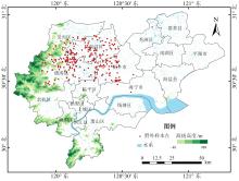
Fig. 1
Spatial distribution of field sampling sites and the location of the Hangjiahu Plain

Table 1
Imagery data for the study of rice planting distribution in the Hangjiahu Plain
| 参数 | Sentinel-1 SAR GRD | Sentinel-2 Level-2A |
|---|---|---|
| 年份 | 2019—2023年 | 2019—2023年 |
| 时间范围 | 6月—12月 | 6月—12月(2020年为次年1月) |
| 含云量 | —— | <30% |
| 成像模式 | IW | —— |
| 极化模式/波段 | VV、VH | B2、B3、B4、B8 |
Table 2
Field sample point survey information
| 地物类型 | 采集时间 | 采集样点数量及说明 |
|---|---|---|
| 水稻 | 2022年7—11月 | 大部分间歇性采样,共获取99个样点;其中有20个样点由移栽期开始,持续1次/月监测至收割 |
| 2023年7—11月 | 大部分间歇性采样,共获取130个样点,其中有20个样点由移栽期开始,持续1次/月监测至收割 | |
| 森林 | 2023年4—9月 | 间歇性采样,共采集84个样点 |
| 其他 | 2023年4—9月 | 间歇性采样,共采集67个样点 |
Table 3
Publicly available rice distribution mapping products covering the Hangjiahu Plain
| 产品简称 | 年份 | 空间分辨率/m | 遥感数据源 | 核心方法 | 数据来源 |
|---|---|---|---|---|---|
| APRA500[ | 2000—2021年 | 500 | Terra/Aqua MODIS | 物候指数特征法 | https://cstr.cn/15732.11.nesdc.ecodb.rs.2022.029 |
| Rice-TWDTW[ | 2017—2023年 | 10 | Sentinel-1/2 | 光谱时序曲线匹配法 | https://cstr.cn/31253.11.sciencedb.06963 |
| EARice10[ | 2023年 | 10 | Sentinel-1/2 | 物候指数特征法 | https://doi.org/10.5281/zenodo.13118409 |
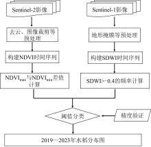
Fig. 2
Technical workflow for rice identification and extraction based on the DNSF-Rice method

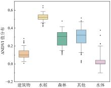
Fig. 3
Distribution of ΔNDVI values for five land cover types in the study of rice planting distribution in the Hangjiahu Plain

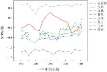
Fig. 4
Temporal variation of SDWI across different land cover types in the study of rice planting distribution in the Hangjiahu Plain

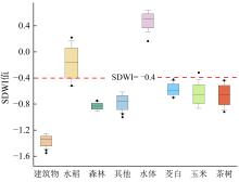
Fig. 5
Distribution of SDWI values for different land cover types during the rice growth period

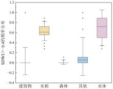
Fig. 6
Frequency distribution of SDWI > -0.4 across different land cover types

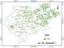
Fig. 7
Rice cultivation distribution of Hangjiahu Plain in 2023

Table 4
Validation results of the rice confusion matrix from 2019 to 2023
| 年份 | UA/% | PA/% | Kappa | OA/% | F 1-Score |
|---|---|---|---|---|---|
| 2019 | 99 | 93 | 0.93 | 96 | 0.96 |
| 2020 | 100 | 93 | 0.93 | 97 | 0.96 |
| 2021 | 99 | 92 | 0.91 | 96 | 0.96 |
| 2022 | 99 | 94 | 0.93 | 97 | 0.97 |
| 2023 | 99 | 96 | 0.95 | 98 | 0.98 |
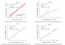
Fig. 8
County-level rice area extraction using the DNSF-Rice method: Validation against official statistics and comparison with existing rice maps

Table 5
Comparison of extracted rice area and statistical area at the county scale in 2023
| 区/县名称 | 提取面积/km2 | 统计面积/km2 | 差值/km2 |
|---|---|---|---|
| 余杭区 | 66.44 | 76.82 | -10.38 |
| 临平区 | 13.52 | 10.73 | 2.79 |
| 德清县 | 39.99 | 52.00 | -12.01 |
| 南浔区 | 94.41 | 119.75 | -25.34 |
| 吴兴区 | 61.47 | 76.06 | -14.59 |
| 海宁市 | 100.03 | 117.60 | -17.57 |
| 桐乡市 | 98.96 | 129.40 | -30.44 |
| 秀洲区 | 113.05 | 130.80 | -17.75 |
| 嘉善县 | 108.79 | 134.20 | -25.41 |
| 平湖市 | 126.45 | 155.70 | -29.25 |
| 南湖区 | 66.40 | 83.30 | -16.9 |
| 海盐县 | 119.61 | 120.90 | -1.29 |
Table 6
Validation results of the rice confusion matrix for different rice mapping products
| 产品名称 | UA/% | PA/% | Kappa | OA/% | F 1-Score |
|---|---|---|---|---|---|
| APRA500水稻制图(500 m,2021年) | 26 | 77 | 0.18 | 59 | 0.39 |
| Rice-TWDTW水稻制图(10 m,2023年) | 51 | 93 | 0.48 | 74 | 0.66 |
| EARice10水稻制图(10 m,2023年) | 93 | 97 | 0.90 | 95 | 0.95 |
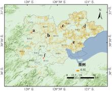
Fig. 9
Spatial distribution of the six selected representative locations in the Hangjiahu Plain

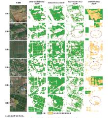
Fig. 10
Comparison of rice mapping results for locations a to Locations f with published data products

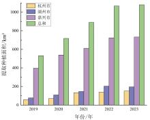
Fig. 11
Rice cultivation area in the Hangjiahu region from 2019 to 2023

| 1 |
FAO. World food and agriculture-Statistical yearbook 2024 [EB/OL]. Rome: FAO, 2024 [2024-11-01].
|
| 2 |
唐志伟, 张俊, 邓艾兴, 等. 我国稻田甲烷排放的时空特征与减排途径[J]. 中国生态农业学报(中英文), 2022, 30(4): 582-591.
|
|
|
|
| 3 |
|
| 4 |
|
| 5 |
|
| 6 |
丁郭明, 陆一轩, 吴陈芊, 等. 21世纪以来江苏省水稻种植面积的变化与启示[J]. 中国农业资源与区划, 2023, 44(9): 101-110.
|
|
|
|
| 7 |
秦叶波, 林宝义, 纪国成. 浙江省粮食生产供给侧改革的思考和建议[J]. 浙江农业科学, 2018, 59(3): 360-362, 369.
|
| 8 |
|
| 9 |
|
| 10 |
|
| 11 |
|
| 12 |
|
| 13 |
|
| 14 |
|
| 15 |
|
| 16 |
|
| 17 |
|
| 18 |
|
| 19 |
|
| 20 |
|
| 21 |
|
| 22 |
|
| 23 |
高心怡, 池泓, 黄进良, 等. 水稻遥感制图研究综述[J]. 遥感学报, 2024, 28(9): 2144-2169.
|
|
|
|
| 24 |
王小娜, 田金炎, 李小娟, 等. Google Earth Engine云平台对遥感发展的改变[J]. 遥感学报, 2022, 26(2): 299-309.
|
|
|
|
| 25 |
|
| 26 |
|
| 27 |
何泽, 李世华. 水稻雷达遥感监测研究进展[J]. 遥感学报, 2023, 27(10): 2363-2382.
|
|
|
|
| 28 |
|
| 29 |
|
| 30 |
|
| 31 |
|
| 32 |
|
| 33 |
|
| 34 |
|
| 35 |
|
| 36 |
|
| 37 |
|
| 38 |
|
| 39 |
|
| 40 |
|
| 41 |
乔树亭, 叶回春, 黄文江, 等. 基于Sentinel-1/2影像的水稻种植面积提取方法研究: 以三江平原为例[J]. 遥感技术与应用, 2023, 38(1): 78-89.
|
|
|
|
| 42 |
|
| 43 |
韩继冲, 张朝. 2000—2021年亚洲季风区主要国家年水稻种植面积数据集[DS/OL]. 国家生态科学数据中心, 2022.
|
|
|
|
| 44 |
|
| 45 |
|
| 46 |
姜伊兰, 陈保旺, 黄玉芳, 等. 基于Google Earth Engine和NDVI时序差异指数的作物种植区提取[J]. 地球信息科学学报, 2021, 23(5): 938-947.
|
|
|
|
| 47 |
贾诗超, 薛东剑, 李成绕, 等. 基于Sentinel-1数据的水体信息提取方法研究[J]. 人民长江, 2019, 50(2): 213-217.
|
|
|
|
| 48 |
|
| 49 |
|
| 50 |
|
| 51 |
|
| 52 |
|
| 53 |
蒋敏, 李秀彬, 辛良杰, 等. 南方水稻复种指数变化对国家粮食产能的影响及其政策启示[J]. 地理学报, 2019, 74(1): 32-43.
|
|
|
|
| 54 |
|
| 55 |
程伟, 钱晓明, 李世卫, 等. 时空遥感云计算平台PIE-Engine Studio的研究与应用[J]. 遥感学报, 2022, 26(2): 335-347.
|
|
|
|
| 56 |
|
| [1] | SONG Mingxuan, BAI Bo, YANG Juntao, ZHANG Yutao, LI Sa, LI Zhenhai, WAN Shubo, LI Guowei. Robust UAV-Based Method for Peanut Plant Height Estimation Using Bare-Soil Invariant Constraints [J]. Smart Agriculture, 2025, 7(6): 124-135. |
| [2] | SUN Rong, GAO Han, JIANG Yujie, LI Qiaochu, WU Haoyu, WU Shangrong, YU Shan, XU Lei, YU Liangliang, ZHANG Jie, BAO Yuhai. Progress in Soil Moisture Retrieval under Crop Canopy Cover Based on Multi-polarization SAR Data [J]. Smart Agriculture, 2025, 7(6): 75-95. |
| [3] | ZHANG Yun, ZHANG Lumin, XU Guangtao, HAO Jiahui. Remote Sensing Extraction Method of Rice-Crayfish Fields Based on Dual-Branch and Multi-Scale Attention [J]. Smart Agriculture, 2025, 7(6): 185-195. |
| [4] | LU Yihang, DONG Wen, ZHANG Xin, YAN Ruoyi, ZHANG Yujia, TANG Tao. Physics-Constrained PROSAIL-cGAN Approach for Spectral Sample Augmentation and LAI Inversion of Winter Wheat [J]. Smart Agriculture, 2025, 7(6): 149-160. |
| [5] | WANG Yinhui, ZHAO Anzhou, LI Dan, ZHU Xiufang, ZHAO Jun, WANG Ziqing. Construction and Evaluation of Lightweight and Interpretable Soybean Remote Sensing Identification Model [J]. Smart Agriculture, 2025, 7(6): 136-148. |
| [6] | LONG Yuqiao, SUN Jing, WEN Yanru, WANG Chuya, DONG Xiuchun, HUANG Ping, WU Wenbin, CHEN Jin, DING Mingzhong. Remote Sensing Approaches for Cropland Abandonment Perception in Southern Hilly and Mountainous Areas of China: A Review [J]. Smart Agriculture, 2025, 7(6): 58-74. |
| [7] | LI Fei, WANG Ziqiang, WU Jing, XIN Xia, LI Chunmei, XU Hubo. Imbalanced Hyperspectral Viability Detection of Naturally Aged Soybean Germplasm Based on Semi-Supervised Deep Convolutional Generative Adversarial Network [J]. Smart Agriculture, 2025, 7(5): 101-113. |
| [8] | LI Ruijie, WANG Aidong, WU Huaxing, LI Ziqiu, FENG Xiangqian, HONG Weiyuan, TANG Xuejun, QIN Jinhua, WANG Danying, CHU Guang, ZHANG Yunbo, CHEN Song. Remote Sensing for Rice Growth Stages Monitoring: Research Progress, Bottleneck Problems and Technical Optimization Paths [J]. Smart Agriculture, 2025, 7(3): 89-107. |
| [9] | MA Liu, MAO Kebiao, GUO Zhonghua. Defogging Remote Sensing Images Method Based on a Hybrid Attention-Based Generative Adversarial Network [J]. Smart Agriculture, 2025, 7(2): 172-182. |
| [10] | ZHAO Bingting, HUA Chuanhai, YE Chenyang, XIONG Yuchun, QIAN Tao, CHENG Tao, YAO Xia, ZHENG Hengbiao, ZHU Yan, CAO Weixing, JIANG Chongya. Research Progress on Remote Sensing Monitoring and Intelligent Decision-Making Algorithms for Rice Production [J]. Smart Agriculture, 2025, 7(2): 57-72. |
| [11] | LI Hao, DU Yuqiu, XIAO Xingzhu, CHEN Yanxi. Remote Sensing Identification Method of Cultivated Land at Hill County of Sichuan Basin Based on Deep Learning [J]. Smart Agriculture, 2024, 6(3): 34-45. |
| [12] | ZHANG Jun, CHEN Yuyan, QIN Zhenyu, ZHANG Mengyao, ZHANG Jun. Remote Sensing Extraction Method of Terraced Fields Based on Improved DeepLab v3+ [J]. Smart Agriculture, 2024, 6(3): 46-57. |
| [13] | QI Jiangtao, CHENG Panting, GAO Fangfang, GUO Li, ZHANG Ruirui. Research Advances and Prospects on Rapid Acquisition Technology of Farmland Soil Physical and Chemical Parameters [J]. Smart Agriculture, 2024, 6(3): 17-33. |
| [14] | LI Tianjun, YANG Xinting, CHEN Xiao, HU Huan, ZHOU Zijie, LI Wenyong. Zero-Shot Pest Identification Based on Generative Adversarial Networks and Visual-Semantic Alignment [J]. Smart Agriculture, 2024, 6(2): 72-84. |
| [15] | SHEN Yanyan, ZHAO Yutao, CHEN Gengshen, LYU Zhengang, ZHAO Feng, YANG Wanneng, MENG Ran. Identification and Severity Classification of Typical Maize Foliar Diseases Based on Hyperspectral Data [J]. Smart Agriculture, 2024, 6(2): 28-39. |
| Viewed | ||||||
|
Full text |
|
|||||
|
Abstract |
|
|||||


