Smart Agriculture ›› 2026, Vol. 8 ›› Issue (2): 72-85.doi: 10.12133/j.smartag.SA202508020
• Topic--Multi-source Remote Sensing Driven Digital Agriculture Innovation and Practice • Previous Articles Next Articles
ZHANG Shulin1, CUI Liqin3, LIU Jian1, ZHANG Canting1, WANG Hongjia1, ZHANG Tingting1, WANG Ailing1,2( )
)
Received:2025-08-21
Online:2026-03-30
Foundation items:National Natural Science Foundation of China(42171378); The Natural Science Foundation of Shandong Province(ZR2021MD018); The Special Funds of Taishan Scholar of Shandong Province(tsqnz20231205)
About author:biography:ZHANG Shulin, E-mail: 2023120274@sdau.edu.cn
corresponding author:
CLC Number:
ZHANG Shulin, CUI Liqin, LIU Jian, ZHANG Canting, WANG Hongjia, ZHANG Tingting, WANG Ailing. Geographically Weighted Random Forest for County-scale Digital Mapping of Soil Organic Matter: A Case Study in the Central Shandong Mountains[J]. Smart Agriculture, 2026, 8(2): 72-85.
Add to citation manager EndNote|Ris|BibTeX
URL: https://www.smartag.net.cn/EN/10.12133/j.smartag.SA202508020
Fig.1
Topography and distribution of sampling points in Yiyuan county, Shandong province
Table 1
Environmental variables and data sources for the SOM prediction model
| 类别 | 名称 | 来源 | 分辨率/m |
|---|---|---|---|
| 气候 | 年均温(Mean Annual Temperature, MAT) | 《1901—2023年中国1 km分辨率逐月平均气温、降水量、潜在蒸发散量数据集》(国家地球系统科学数据中心,https://www.geodata.cn/) | 1 000 |
| 年降水(Mean Annual Precipitation, MAP) | |||
| 年蒸散(Mean Annual Evapotranspiration, MAE) | |||
| 土壤 | 土壤类型(Soil Type, ST) | 全国第二次土壤普查土壤类型图 | – |
| 黏粒含量(Clay) | 《中国高分辨率国家土壤信息格网基本属性数据集_90米土壤砂粒、粉粒、黏粒含量》(国家地球系统科学数据中心,https://www.geodata.cn/) | 90 | |
| 粉粒含量(Silt) | |||
| 砂粒含量(Sand) | |||
| 地形 | 高程(DEM) | ASTER GDEM 30 m数据 (地理空间数据云,https://www.gscloud.cn/) | 30 |
| 坡度(Slope) | |||
| 坡向(Aspect) | |||
| 平面曲率(Plan) | |||
| 剖面曲率(Profile) | |||
| 地形位置指数(Topographic Position Index, TPI) | |||
| 地形湿度指数(Topographic Wetness Index, TWI) | |||
| 径流强度指数(Stream Power Index, SPI) | |||
| 植被 | 归一化植被指数(Normalized Difference Vegetation Index, NDVI) | 《Landsat 8-9 OLI/TIRS C2 L2》 (地理空间数据云,https://www.gscloud.cn/) | 30 |
| 增强型植被指数(Enhanced Vegetation Index, EVI) | |||
| 土壤调整植被指数(Soil-Adjusted Vegetation Index, SAVI) | |||
| 土地利用 | 土地利用方式(Land Use, LU) | 国土变更调查数据 | – |
Fig. 2
Modeling workflow of the GWRF model
Table 2
Descriptive statistics of SOM in Yiyuan county, Shandong province
| 数量 | 最小值/(g/kg) | 最大值/(g/kg) | 平均值/(g/kg) | 标准差/(g/kg) | 变异系数/% | 偏度 | 峰度 |
|---|---|---|---|---|---|---|---|
| 1 565 | 2.0 | 51.1 | 15.62 | 7.45 | 47.70 | 0.53 | -0.17 |
Table 3
Classification standards for SOM indicators in cultivated land quality monitoring of Shandong province
| 级别/(g/kg) | Ⅰ级(高)>25.0 | Ⅱ级(较高)(20.0,25.0] | Ⅲ级(中)(15.0,20.0] | Ⅳ级(较低)(10.0,15.0] | Ⅴ级(低)≤10.0 |
|---|---|---|---|---|---|
| 样点数量 | 170 | 173 | 371 | 501 | 350 |
| 样点占比/% | 10.86 | 11.05 | 23.71 | 32.01 | 22.37 |
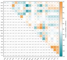
Fig. 3
Correlation heatmap between SOM and environmental

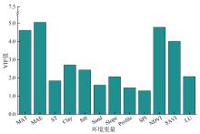
Fig. 4
Screening results of environmental variable VIF
Table 4
Results of the MLR model and the GWR model for SOM digital mapping
| 模型 | RSS | AICc | R 2 | Adjusted R 2 |
|---|---|---|---|---|
| MLR | 37 851.59 | 9 319.46 | 0.38 | 0.32 |
| GWR | 29 578.75 | 8 711.93 | 0.46 | 0.37 |
Table 5
Regression coefficients of the MLR model and the GWR model
| 环境变量 | MLR模型 回归系数 | GWR模型回归系数 | |||
|---|---|---|---|---|---|
| 最小值 | 中位数 | 最大值 | 平均值 | ||
| 截距 | 7.29* | -18.03 | 8.47 | 51.12 | 12.23* |
| MAT | -1.65 | -59.31 | -0.84 | 21.06 | -8.71* |
| MAE | -1.56* | -24.90 | -2.68 | 13.62 | -3.13* |
| ST | 16.11* | 10.06 | 15.01 | 22.00 | 15.13* |
| Clay | -4.12* | -10.61 | -0.47 | 12.68 | -0.46 |
| Silt | 0.57 | -10.95 | -2.68 | 13.46 | -1.80 |
| Sand | 5.79* | -16.09 | -3.87 | 11.37 | -3.93* |
| Slope | 1.75 | -15.59 | -0.05 | 25.21 | 1.35 |
| Profile | 0.61 | -22.67 | -0.08 | 22.36 | -1.18 |
| SPI | 2.80 | -13.66 | 2.22 | 16.88 | 2.22 |
| NDVI | 1.95 | -35.79 | -1.73 | 26.47 | -2.17 |
| SAVI | -1.30 | -30.65 | 0.17 | 35.21 | 0.92 |
| LU | 3.88* | -18.11 | 1.75 | 13.11 | 1.93 |
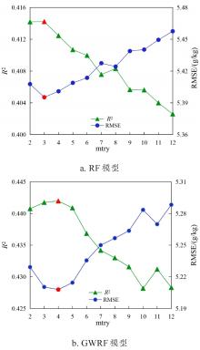
Fig. 5
Results of mtry determination for RF and GWRF models
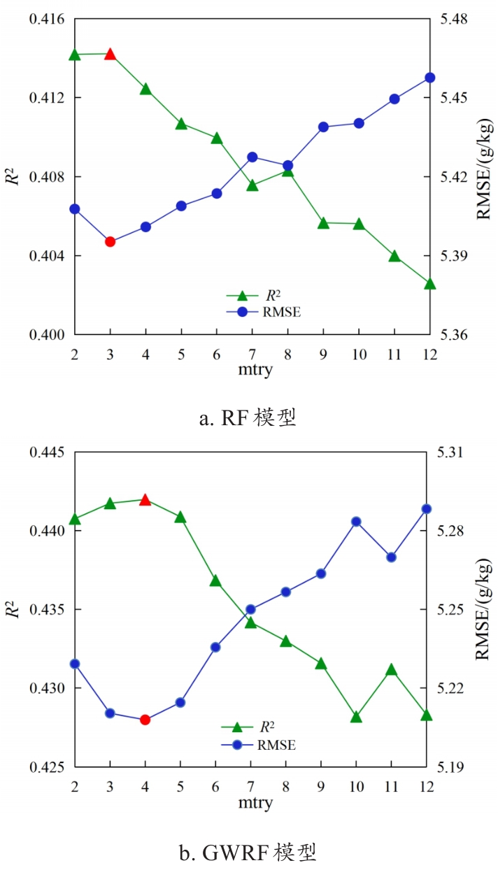

Fig. 6
Bandwidth test results of GWRF model
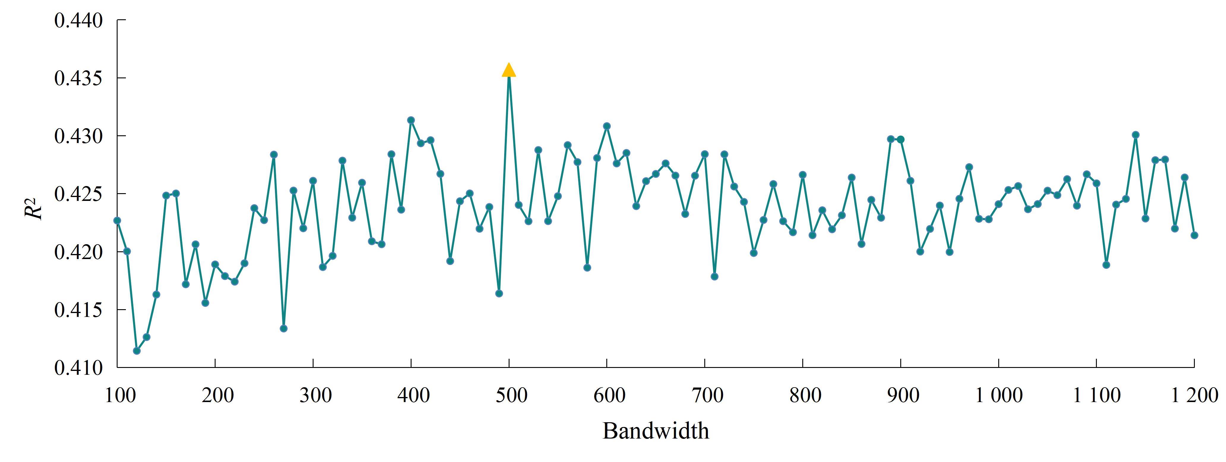
Table 6
Accuracy comparison of SOM mapping models
| 制图模型 | OK | MLR | GWR | RF | GWRF |
|---|---|---|---|---|---|
| R 2 | 0.24 | 0.32 | 0.35 | 0.41 | 0.48 |
| RMSE/(g/kg) | 6.18 | 5.85 | 5.71 | 5.48 | 5.12 |
Table 7
Significance test of prediction accuracy differences between GWRF and other models
| 模型对比 | 指标 | 平均差值 | t值 | 自由度 | 显著性(P值) |
|---|---|---|---|---|---|
| GWRF-OK | R 2 | 0.24 | 29.79 | 19 | <0.01 |
| RMSE | -1.06 | -35.55 | 19 | <0.01 | |
| GWRF-MLR | R 2 | 0.16 | 19.03 | 19 | <0.01 |
| RMSE | -0.73 | -23.26 | 19 | <0.01 | |
| GWRF-GWR | R 2 | 0.13 | 13.91 | 19 | <0.01 |
| RMSE | -0.59 | -18.03 | 19 | <0.01 | |
| GWRF-RF | R 2 | 0.07 | 4.32 | 19 | <0.01 |
| RMSE | -0.36 | -5.56 | 19 | <0.01 |
Fig. 7
Scatter plots of SOM prediction by different models in Yiyuan county
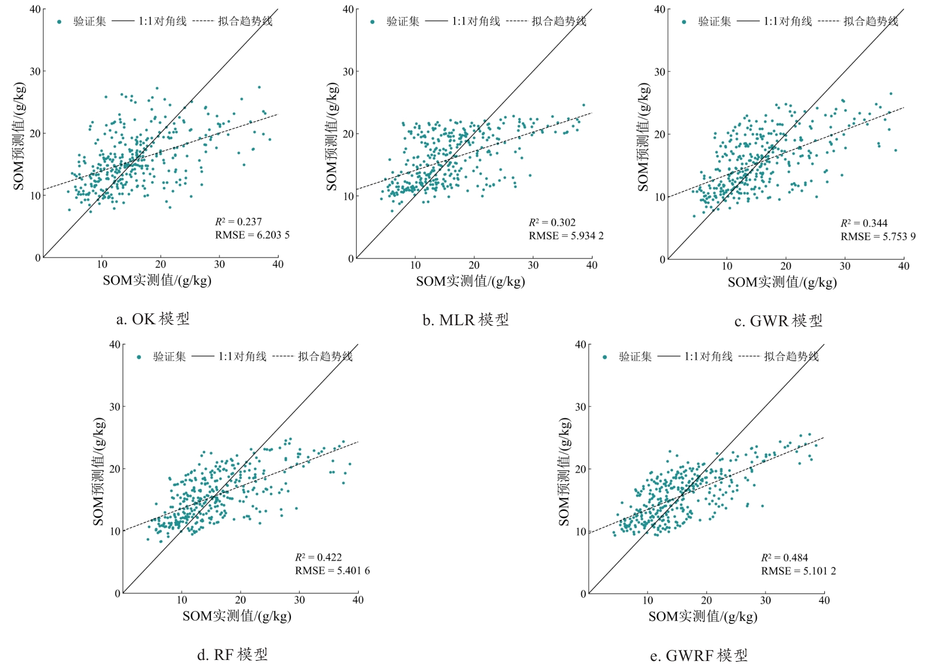

Fig. 8
Comparison of mapping performance of different models for SOM digital mapping
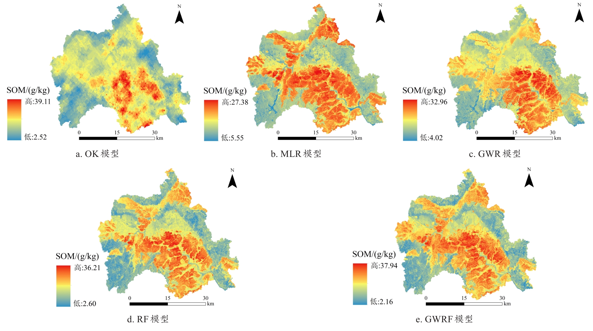
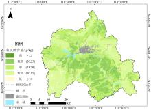
Fig. 9
Spatial distribution of SOM content in Yiyuan county

Fig. 10
Ranking of environmental variable importance for RF and GWRF models for SOM digital mapping
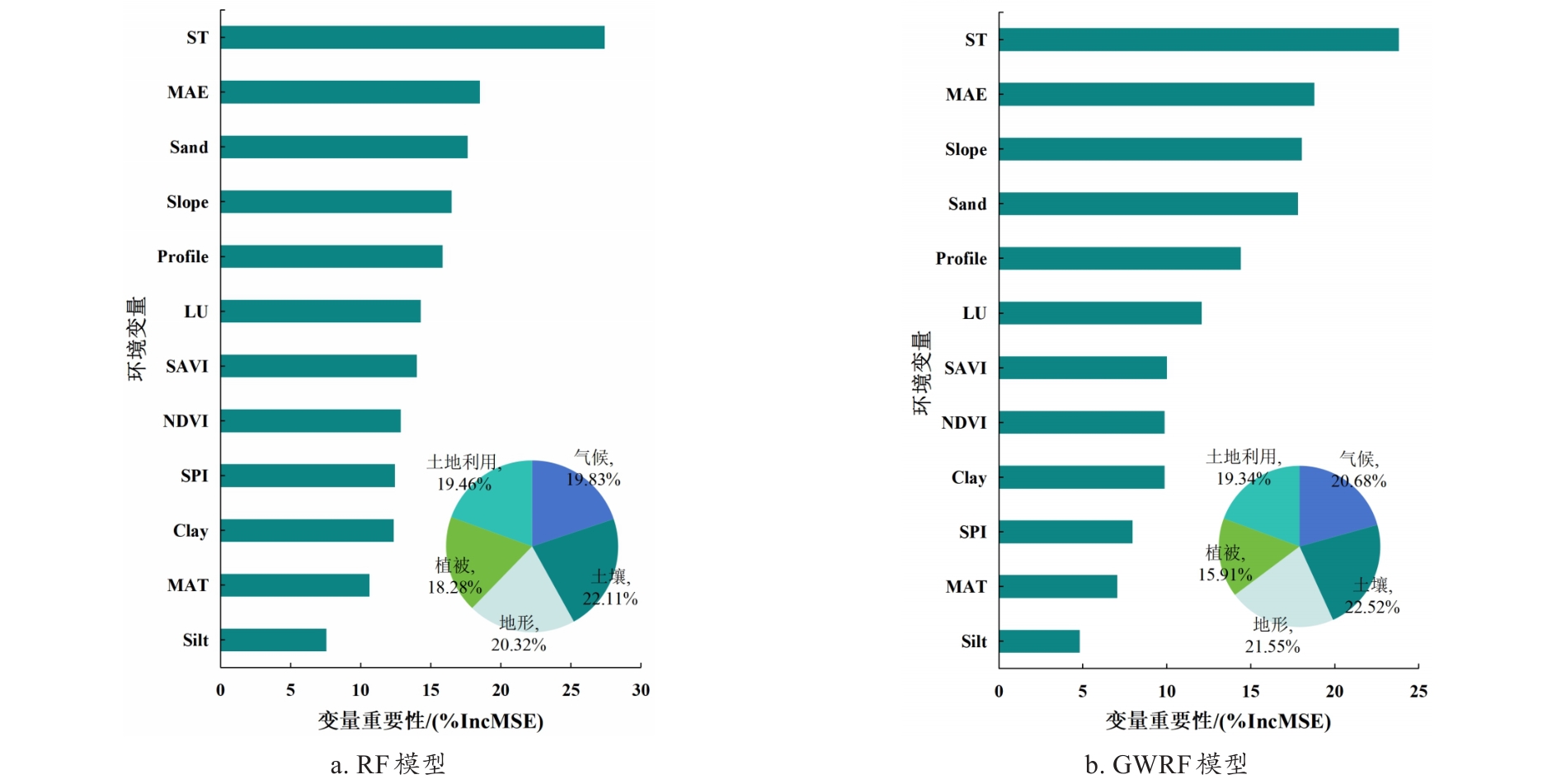
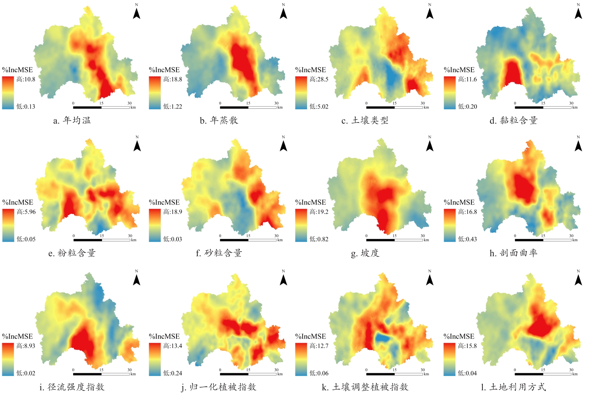
Fig. 11
Spatial distribution of environmental variable importance scores of the GWRF model for SOM digital mapping
| [1] |
王雨雪, 杨柯, 高秉博, 等. 基于两点机器学习方法的土壤有机质空间分布预测[J]. 农业工程学报, 2022, 38(12): 65-73.
|
|
|
|
| [2] |
|
| [3] |
沈仁芳, 颜晓元, 张甘霖, 等. 新时期中国土壤科学发展现状与战略思考[J]. 土壤学报, 2020, 57(5): 1051-1059.
|
|
|
|
| [4] |
朱阿兴, 杨琳, 樊乃卿, 等. 数字土壤制图研究综述与展望[J]. 地理科学进展, 2018, 37(1): 66-78.
|
|
|
|
| [5] |
|
| [6] |
刘顺国, 徐英德, 裴久渤, 等. 以土壤普查成果助推黑土地科学保护与利用[J]. 土壤通报, 2024, 55(4): 1185-1190.
|
|
|
|
| [7] |
曹佳萍, 张黎明, 邱龙霞, 等. 基于稀疏样点的南方丘陵地区耕地土壤有效磷制图[J]. 中国生态农业学报(中英文), 2022, 30(2): 290-301.
|
|
|
|
| [8] |
王奇, 王世航, 陶勤, 等. 典型黑土区农场尺度土壤属性数字制图方法对比研究[J]. 土壤, 2025, 57(2): 430-444.
|
|
|
|
| [9] |
陈琳, 任春颖, 王宗明, 等. 基于克里金插值的耕地表层土壤有机质空间预测[J]. 干旱区研究, 2017, 34(4): 798-805.
|
|
|
|
| [10] |
李梦佳, 王磊, 刘洪斌, 等. 不同模型预测土壤有机质含量空间分布对比分析[J]. 西南农业学报, 2021, 34(3): 610-617.
|
|
|
|
| [11] |
|
| [12] |
王幼奇, 张兴, 赵云鹏, 等. 基于GIS和地理加权回归的砂田土壤阳离子交换量空间预测[J]. 土壤, 2020, 52(2): 421-426.
|
|
|
|
| [13] |
仇皓雷, 王海燕. 机器学习在土壤性质预测研究中的应用进展[J]. 生态学杂志, 2025, 44(1): 283-294.
|
|
|
|
| [14] |
薄延素, 李昊明, 王葛霏, 等. 松嫩平原西部草地土壤有机质含量预测[J]. 水土保持研究, 2025, 32(3): 63-71.
|
|
|
|
| [15] |
胡志瑞, 赵万伏, 宋垠先, 等. 基于改进麻雀搜索算法优化BP神经网络的土壤有机质空间分布预测[J]. 环境科学, 2024, 45(5): 2859-2870.
|
|
|
|
| [16] |
李兰晖, 黄聪聪, 张镱锂, 等. 基于地理加权随机森林的青藏地区放牧强度时空格局模拟[J]. 地理科学, 2023, 43(3): 398-410.
|
|
|
|
| [17] |
|
| [18] |
卫格冉, 李明泽, 全迎, 等. 基于地理加权随机森林的黑龙江省森林碳储量遥感估测[J]. 中南林业科技大学学报, 2024, 44(7): 64-76.
|
|
|
|
| [19] |
李泽, 杜哲, 毕善婷, 等. 基于GWRF模型的滨海平原土壤含盐量预测及影响因素分析[J]. 环境科学, 2025, 46(8): 4982-4992.
|
|
|
|
| [20] |
姚彩燕, 刘绍贵, 乔婷, 等. 基于时空变异的旱地土壤有机碳高效采样策略研究[J]. 土壤学报, 2021, 58(3): 638-648.
|
|
|
|
| [21] |
孟祥添. 基于深度学习模型东北耕作土壤有机碳时空分布及驱动因素研究[D]. 哈尔滨: 中国科学院大学(中国科学院东北地理与农业生态研究所), 2024.
|
|
|
|
| [22] |
任艳, 尹秋月, 尹晋磊, 等. 南亚热带典型岩溶区耕地土壤有机质空间分布预测的方法比较[J]. 土壤, 2025, 57(3): 673-682.
|
|
|
|
| [23] |
陈艺敏, 苏漳文, 陈移萍, 等. 基于地理加权随机森林的长三角PM2.5建模[J]. 中国环境科学, 2024, 44(8): 4240-4248.
|
|
|
|
| [24] |
|
| [25] |
|
| [26] |
|
| [27] |
|
| [28] |
|
| [29] |
杨之江, 陈效民, 景峰, 等. 基于GIS和地统计学的稻田土壤养分与重金属空间变异[J]. 应用生态学报, 2018, 29(6): 1893-1901.
|
|
|
|
| [30] |
陈宣强, 赵明松, 卢宏亮, 等. 基于3种地理加权回归方法的安徽省土壤pH空间预测制图对比研究[J]. 地理科学, 2023, 43(1): 173-183.
|
|
|
|
| [31] |
|
| [32] |
董雨昕, 韩文霆, 崔欣, 等. 基于无人机与Sentinel-2A遥感数据协同的裸土期土壤含盐量反演[J]. 农业机械学报, 2025, 56(6): 434-445.
|
|
|
|
| [33] |
袁玉琦, 陈瀚阅, 张黎明, 等. 基于多变量与RF算法的耕地土壤有机碳空间预测研究: 以福建亚热带复杂地貌区为例[J]. 土壤学报, 2021, 58(4): 887-899.
|
|
|
|
| [34] |
卢宾宾, 葛咏, 秦昆, 等. 地理加权回归分析技术综述[J]. 武汉大学学报(信息科学版), 2020, 45(9): 1356-1366.
|
|
|
|
| [35] |
|
| [36] |
葛畅, 刘慧琳, 聂超甲, 等. 土壤肥力及其影响因素的尺度效应: 以北京市平谷区为例[J]. 资源科学, 2019, 41(4): 753-765.
|
|
|
|
| [37] |
|
| [38] |
解文艳, 周怀平, 杨振兴, 等. 黄土高原东部潇河流域农田土壤有机质时空变异及影响因素[J]. 农业资源与环境学报, 2019, 36(1): 96-104.
|
|
|
|
| [39] |
咸阳, 宋江辉, 王金刚, 等. 基于环境变量筛选与机器学习的土壤养分含量空间插值研究[J]. 农业机械学报, 2024, 55(10): 379-391.
|
|
|
| [1] | LIAN Zhenxiang, FEI Xufeng, REN Zhouqiao. Optimal Sampling Strategy for Soil Organic Matter Based on Hippopotamus Optimization Algorithm and Machine Learning [J]. Smart Agriculture, 2026, 8(2): 48-58. |
| [2] | CHEN Ailian, ZHANG Rusheng, LI Ran, ZHAO Sijian, ZHU Yuxia, LAI Jibao, SUN Wei, ZHANG Jing. Cross-validation Study on the Authenticity of Agricultural Insurance Underwriting Based on Multi-Source Satellite Remote Sensing Data: Taking Multi-Season Rice in M County, S Province as A Case [J]. Smart Agriculture, 2025, 7(6): 225-236. |
| [3] | LONG Yuqiao, SUN Jing, WEN Yanru, WANG Chuya, DONG Xiuchun, HUANG Ping, WU Wenbin, CHEN Jin, DING Mingzhong. Remote Sensing Approaches for Cropland Abandonment Perception in Southern Hilly and Mountainous Areas of China: A Review [J]. Smart Agriculture, 2025, 7(6): 58-74. |
| [4] | MU Xiaodong, YANG Fuzeng, DUAN Luojia, LIU Zhijie, SONG Zhuoying, LI Zonglin, GUAN Shouqing. Research Advances and Development Trend of Mountainous Tractor Leveling and Anti-Rollover System [J]. Smart Agriculture, 2024, 6(3): 1-16. |
| [5] | LAI Jiazheng, LI Beibei, CHENG Xiang, SUN Feng, CHENG Juting, WANG Jing, ZHANG Qian, YE Xiefeng. Monitoring of Leaf Chlorophyll Content in Flue-Cured Tobacco Based on Hyperspectral Remote Sensing of Unmanned Aerial Vehicle [J]. Smart Agriculture, 2023, 5(2): 68-81. |
| [6] | YANG Lin, YANG Bin, REN Qingshan, YANG Xinting, HAN Jiawei. Evaluation and Countermeasures on the Development Level of Intelligent Cold Chain in China [J]. Smart Agriculture, 2023, 5(1): 22-33. |
| [7] | FAN Chengzhi, WANG Ziwen, YANG Xingchao, LUO Yongkai, XU Xuexin, GUO Bin, LI Zhenhai. Machine Learning Inversion Model of Soil Salinity in the Yellow River Delta Based on Field Hyperspectral and UAV Multispectral Data [J]. Smart Agriculture, 2022, 4(4): 61-73. |
| [8] | LI Dongbo, HUANG Lyuwen, ZHAO Xubo. Detection Method of Apple Mould Core Based on Dielectric Characteristics [J]. Smart Agriculture, 2021, 3(4): 66-76. |
| [9] | YIN Hang, LI Xiangtong, XU Longqin, LI Jingbin, LIU Shuangyin, CAO Liang, FENG Dachun, GUO Jianjun, LI Liqiao. EMD-RF-LSTM: Combination Prediction Model of Dissolved Oxygen Concentration in Prawn Culture [J]. Smart Agriculture, 2021, 3(2): 115-125. |
| [10] | SHAO Guomin, WANG Yajie, HAN Wenting. Estimation Method of Leaf Area Index for Summer Maize Using UAV-Based Multispectral Remote Sensing [J]. Smart Agriculture, 2020, 2(3): 118-128. |
| [11] | LIU Tianlin, ZHU Xicun, BAI Xueyuan, PENG Yufeng, LI Meixuan, TIAN Zhongyu, JIANG Yuanmao, YANG Guijun. Hyperspectral Estimation Model Construction and Accuracy Comparison of Soil Organic Matter Content [J]. Smart Agriculture, 2020, 2(3): 129-138. |
| Viewed | ||||||
|
Full text |
|
|||||
|
Abstract |
|
|||||


