Smart Agriculture ›› 2025, Vol. 7 ›› Issue (6): 18-34.doi: 10.12133/j.smartag.SA202506025
• 专刊--遥感+AI 赋能农业农村现代化 • 上一篇 下一篇
兰玉彬1,2,3, 王朝锋1,2, 孙贺光1,2, 陈盛德1,2, 王国宾3, 邓小玲1,2( ), 王元杰4()
收稿日期:2025-06-13
出版日期:2025-11-30
基金项目:作者简介:通信作者:
LAN Yubin1,2,3, WANG Chaofeng1,2, SUN Heguang1,2, CHEN Shengde1,2, WANG Guobin3, DENG Xiaoling1,2(), WANG Yuanjie4()
Received:2025-06-13
Online:2025-11-30
Foundation items:Key Research and Development Program Project of Guangdong Province(2023B0202090001); Precision Agriculture Aviation Application Technology Discipline Innovation and Talent Introduction Base ('Base 111')(D18019); National Natural Science Foundation of China General Program(32371984); National Key Research and Development Program Project(2023YFD2000200); Key Technologies and Equipment for Precision Agricultural Aviation(NT2021009); National Cotton Industry Technology System(CARS-15-22)
About author:Corresponding author:摘要:
[目的/意义] 随着低空技术在通信传输、负载能力和智能算法上的快速迭代,农业生产的作业模式正发生深刻变革。以无人机为代表的低空飞行器作为低空技术在农业领域的核心载体,已从单一的植保工具升级为集数据采集、长势监测、精准喷施于一体的智能农业平台,通过“三维一体”技术化体系重构农田管理方式,推动传统农业向数字化、网络化、智能化的智慧农业跨越。 [进展] 本文首先介绍了低空技术赋能智慧农业的作用机制,结合低空作业装备、低空遥感与识别技术、低空数据处理与分析技术、精准作业与监管技术介绍了农业低空技术体系。之后分析了低空技术赋能智慧农业的应用场景,重点介绍了低空技术在智慧果园和生态无人农场的实践。 [结论/展望] 目前发展以低空技术为载体的农业低空经济面临技术、成本、标准、生态,以及人才等多方面的挑战,本研究提出了打造垂直整合、水平扩展、时空协同“三维一体”技术体系,完善技术标准,构建全链条融合的农业低空产业生态,强化政策引领与人才培育,激活农业低空经济新动能等促进农业低空经济发展的系列建议,可为未来低空技术农业应用及发展农业低空经济提供方向指南。
中图分类号:
兰玉彬, 王朝锋, 孙贺光, 陈盛德, 王国宾, 邓小玲, 王元杰. 低空技术赋能智慧农业:技术体系、应用场景及挑战建议[J]. 智慧农业(中英文), 2025, 7(6): 18-34.
LAN Yubin, WANG Chaofeng, SUN Heguang, CHEN Shengde, WANG Guobin, DENG Xiaoling, WANG Yuanjie. Low-Altitude Technology Empowering Smart Agriculture: Technical System, Application Scenarios, and Challenge Recommendations[J]. Smart Agriculture, 2025, 7(6): 18-34.
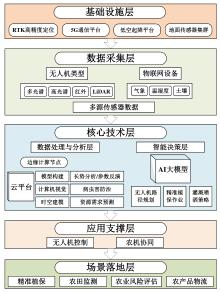
图1
低空技术助力智慧农业新范式

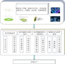
图2
农业低空技术体系
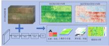
图3
多知识耦合的棉花水、氮自适应作业处方图生成系统
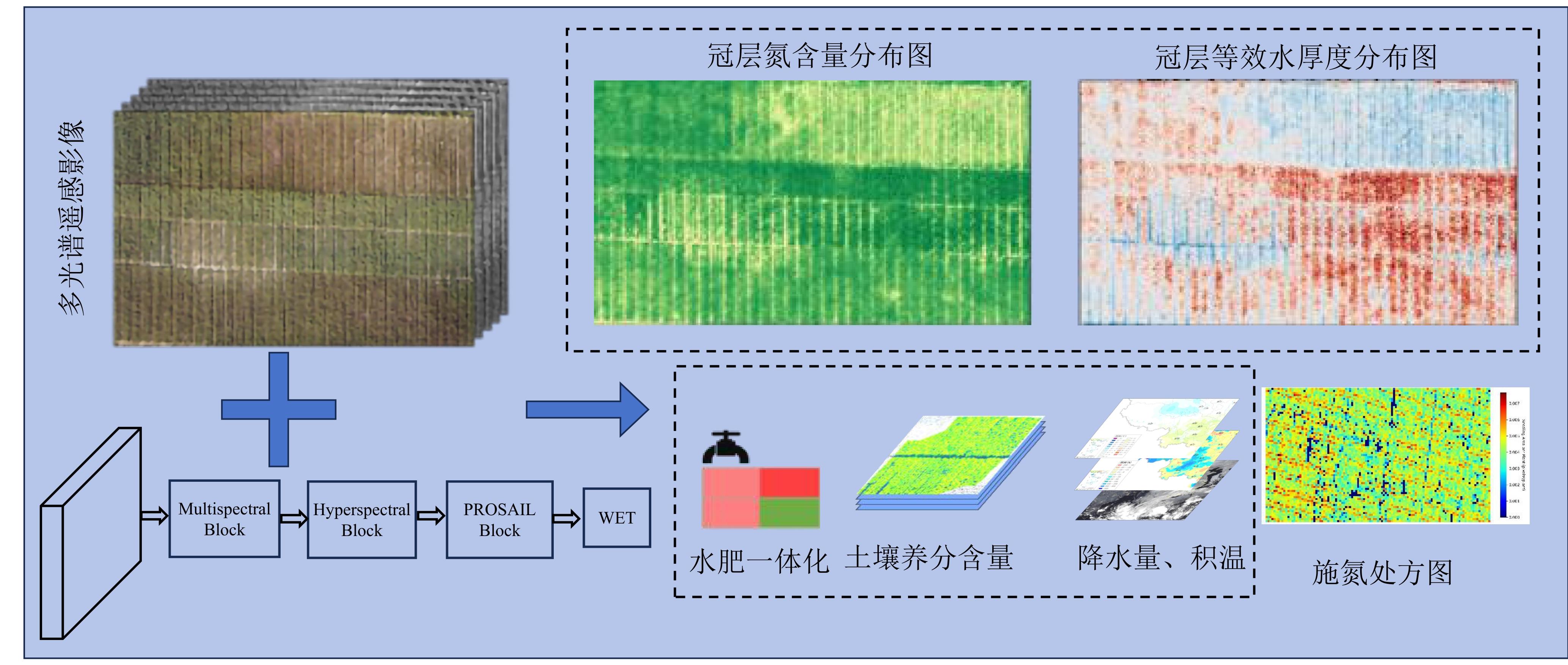
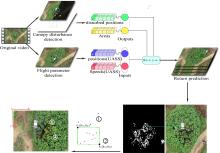
图4
荔枝树冠扰动预测的时间序列模型

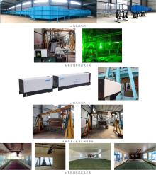
图5
风洞喷雾测试装置和系统

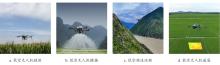
图6
低空技术在农业中的主要应用场景
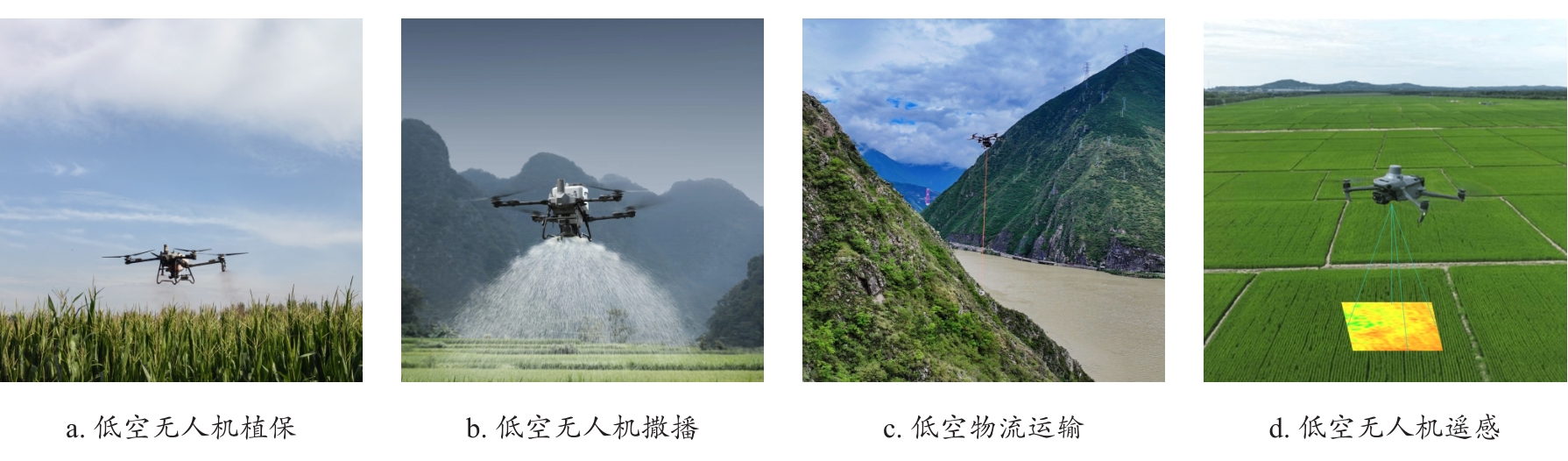
图7
“智巡”系统和“荔知君”AI大模型 a. 智巡系统 b. “荔知君”AI大模型

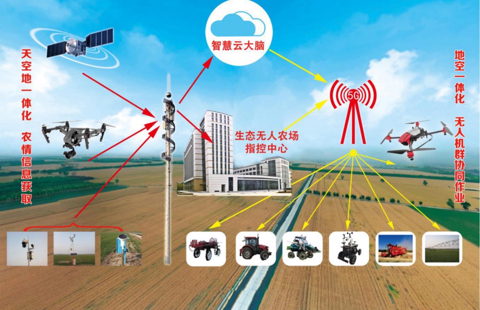
图8
生态无人农场概念图
| [1] |
兰玉彬. 我国精准农业航空现状与作用[J]. 农机市场, 2021(4): 23-24.
|
| [2] |
庞博. "低空+农业" 如何起飞?[N]. 农民日报, 2024-12-17(8).
|
| [3] |
王宝义, 张萌萌. 我国低空经济发展的理论逻辑与实施要点[J]. 中国流通经济, 2025, 39(5): 59-72.
|
|
|
|
| [4] |
何勇, 王月影, 何立文, 等. 低空经济政策和技术在农业农村的应用现状与前景[J]. 农业工程学报, 2025, 41(8): 1-16.
|
|
|
|
| [5] |
司超国, 刘梦晨, 吴华瑞, 等. Chilli-YOLO: 基于改进YOLOv10的露地辣椒成熟度智能检测算法[J]. 智慧农业(中英文), 2025, 7(2): 160-171.
|
|
|
|
| [6] |
李阳德, 马晓慧, 王骥. 基于轻量级MobileNet V3-YOLOv4的生长期菠萝成熟度分析[J]. 智慧农业(中英文), 2023, 5(2): 35-44.
|
|
|
|
| [7] |
聂鹏程, 钱程, 覃锐苗, 等. 天空地一体化信息感知与融合技术发展现状与趋势[J]. 智能化农业装备学报(中英文), 2023, 4(2): 1-11.
|
|
|
|
| [8] |
高心怡, 池泓, 黄进良, 等. 水稻遥感制图研究综述[J]. 遥感学报, 2024, 28(9): 2144-2169.
|
|
|
|
| [9] |
|
| [10] |
竞霞, 黄文江, 琚存勇, 等. 基于PLS算法的棉花黄萎病高空间分辨率遥感监测[J]. 农业工程学报, 2010, 26(8): 229-235.
|
|
|
|
| [11] |
汪沛, 张俊雄, 兰玉彬, 等. 多光谱低空遥感图像光照辐射度校正[J]. 农业工程学报, 2014, 30(19): 199-206.
|
|
|
|
| [12] |
赵柄婷, 华传海, 叶晨洋, 等. 水稻生产遥感监测与智慧决策研究进展[J]. 智慧农业(中英文), 2025, 7(2): 57-72.
|
|
|
|
| [13] |
|
| [14] |
|
| [15] |
|
| [16] |
|
| [17] |
|
| [18] |
|
| [19] |
|
| [20] |
|
| [21] |
|
| [22] |
|
| [23] |
茹煜. 农药航空静电喷雾系统及其应用研究[D]. 南京: 南京林业大学, 2009.
|
|
|
|
| [24] |
茹煜, 金兰, 贾志成, 等. 无人机静电喷雾系统设计及试验[J]. 农业工程学报, 2015, 31(8): 42-47.
|
|
|
|
| [25] |
张亚莉, 黄鑫荣, 王林琳, 等. 国外农业航空静电喷雾技术研究进展与借鉴[J]. 农业工程学报, 2021, 37(6): 50-59.
|
|
|
|
| [26] |
吴辉, 王秀, 张晋国, 等. 圆盘式施肥机抛撒模型中圆盘转速的试验研究[J]. 农机化研究, 2007, 29(7): 136-139.
|
|
|
|
| [27] |
毕银丽, 张龙杰, 白雪蕊. 无人机飞播参数优选与DSE浸种荞麦生态修复效应研究[J]. 矿业科学学报, 2023, 8(5): 695-703.
|
|
|
|
| [28] |
封润泽, 韩鑫, 兰玉彬, 等. 基于高光谱和CNN-LSTM的白菜叶片铜胁迫分析与分类模型研究[J]. 农业机械学报, 2025, 56(6): 477-486.
|
|
|
|
| [29] |
李新龙, 兰玉彬, 王会征. 基于改进YOLOv10n的自然场景下芒果果实与果梗检测方法[J]. 农业工程学报, 2025, 41(19): 167-175.
|
|
|
|
| [30] |
于海琳, 兰玉彬, 李京谦, 等. 基于无人机遥感数据和机器学习的向日葵LAI反演[J]. 农业机械学报, 2025, 56(1): 356-365.
|
|
|
|
| [31] |
|
| [32] |
钱凤魁, 王化军, 王祥国, 等. 基于WOFOST模型与遥感数据同化的县级尺度玉米估产研究[J]. 沈阳农业大学学报, 2024, 55(2): 138-152.
|
|
|
|
| [33] |
|
| [34] |
龙佳宁, 张昭, 刘晓航, 等. 利用改进EfficientNetV2和无人机图像检测小麦倒伏类型[J]. 智慧农业(中英文), 2023, 5(3): 62-74.
|
|
|
|
| [35] |
|
| [36] |
|
| [37] |
|
| [38] |
|
| [39] |
|
| [40] |
|
| [41] |
|
| [42] |
|
| [43] |
|
| [44] |
张悦, 宋月鹏, 韩云, 等. 丘陵山区果园植保机械研究现状及发展趋势[J]. 中国农机化学报, 2020, 41(5): 47-52.
|
|
|
|
| [45] |
|
| [46] |
|
| [47] |
|
| [48] |
兰玉彬, 朱梓豪, 邓小玲, 等. 基于无人机高光谱遥感的柑橘黄龙病植株的监测与分类[J]. 农业工程学报, 2019, 35(3): 92-100.
|
|
|
|
| [49] |
|
| [50] |
|
| [51] |
兰玉彬, 邓小玲, 曾国亮. 无人机农业遥感在农作物病虫草害诊断应用研究进展[J]. 智慧农业, 2019, 1(2): 1-19.
|
|
|
|
| [52] |
|
| [53] |
徐旻, 张瑞瑞, 陈立平, 等. 智能化无人机植保作业关键技术及研究进展[J]. 智慧农业, 2019, 1(2): 20-33.
|
|
|
|
| [54] |
陈岚, 陈心怡. 突破智能运送技术瓶颈 智慧管控助农节本增效: 专访华南农业大学电子工程学院(人工智能学院)副院长李震教授[J]. 广东科技, 2023, 32(1): 26-33.
|
| [55] |
兰玉彬, 林泽山, 王林琳, 等. 基于文献计量学的智慧果园研究进展与热点分析[J]. 农业工程学报, 2022, 38(21): 127-136.
|
|
|
|
| [56] |
吴文斌, 史云, 段玉林, 等. 天空地遥感大数据赋能果园生产精准管理[J]. 中国农业信息, 2019, 31(4): 1-9.
|
|
|
|
| [57] |
殷献博, 邓小玲, 兰玉彬, 等. 基于改进YOLOX-Nano算法的柑橘梢期长势智能识别[J]. 华南农业大学学报, 2023, 44(1): 142-150.
|
|
|
|
| [58] |
兰玉彬, 王天伟, 郭雅琦, 等. 柑橘黄龙病光谱特征波段选择及光谱检测仪研制[J]. 农业工程学报, 2022, 38(20): 119-128.
|
|
|
|
| [59] |
张建桃, 林耿纯, 陈鸿, 等. 柑橘黄龙病远红外热处理温度场分布特性试验研究[J]. 农业机械学报, 2019, 50(10): 175-188.
|
|
|
|
| [60] |
|
| [61] |
陆向龙, 吴春笃, 杨官学, 等. 改进A*和DWA算法的果园喷雾机器人路径规划[J]. 计算机工程与应用, 2023, 59(18): 323-328.
|
|
|
|
| [62] |
肖志成. 基于无人机影像的脐橙树单木信息提取研究[D]. 赣州: 江西理工大学, 2024.
|
|
|
| [1] | 宋明轩, 白波, 杨俊涛, 张宇涛, 李飒, 李振海, 万书波, 李国卫. 裸地不变量约束的花生株高无人机稳健估算方法[J]. 智慧农业(中英文), 2025, 7(6): 124-135. |
| [2] | 曹玉莹, 刘银川, 高新悦, 贾银江, 董守田. LightTassel-YOLO:一种基于无人机遥感的玉米雄穗实时检测方法[J]. 智慧农业(中英文), 2025, 7(6): 96-110. |
| [3] | 王学昌, 徐文波, 郑永军, 杨圣慧, 刘星星, 苏道毕力格, 王子蒙. 果园低空经济产业现状与发展趋势[J]. 智慧农业(中英文), 2025, 7(6): 35-57. |
| [4] | 何勇, 戴馥霜, 朱姜蓬, 何立文, 王月影. 农业低空经济应用场景及产业发展现状与趋势[J]. 智慧农业(中英文), 2025, 7(6): 1-17. |
| [5] | 赵莹萍, 梁锦名, 陈贝章, 邓小玲, 张奕, 熊征, 潘明, 孟祥宝. 多智能体大模型在农业中的应用研究与展望[J]. 智慧农业(中英文), 2025, 7(5): 37-51. |
| [6] | 谢纪元, 张东彦, 牛圳, 程涛, 苑峰, 刘亚玲. 基于YOLOv10-MHSA的“三北”工程内蒙古地区植树位点精准检测研究[J]. 智慧农业(中英文), 2025, 7(3): 108-119. |
| [7] | 赵柄婷, 华传海, 叶晨洋, 熊育春, 钱涛, 程涛, 姚霞, 郑恒彪, 朱艳, 曹卫星, 江冲亚. 水稻生产遥感监测与智慧决策研究进展[J]. 智慧农业(中英文), 2025, 7(2): 57-72. |
| [8] | 于丰华, 许童羽, 郭忠辉, 白驹驰, 相爽, 国斯恩, 金忠煜, 李世隆, 王世宽, 刘美含, 惠尹宣. 水稻智慧无人农场关键技术研究现状与展望[J]. 智慧农业(中英文), 2024, 6(6): 1-22. |
| [9] | 彭小丹, 陈锋军, 朱学岩, 才嘉伟, 顾梦梦. 基于无人机图像和改进LSC-CNN模型的密集苗木检测和计数方法[J]. 智慧农业(中英文), 2024, 6(5): 88-97. |
| [10] | 曹冰雪, 李鸿飞, 赵春江, 李瑾. 智慧农业科技创新引领农业新质生产力发展路径[J]. 智慧农业(中英文), 2024, 6(4): 116-127. |
| [11] | 庞春晖, 陈鹏, 夏懿, 章军, 王兵, 邹岩, 陈天娇, 康辰瑞, 梁栋. 用于小麦多生长阶段倒伏边界精准检测的分层交互特征金字塔网络[J]. 智慧农业(中英文), 2024, 6(2): 128-139. |
| [12] | 王儒敬. 农业传感器:研究进展、挑战与展望[J]. 智慧农业(中英文), 2024, 6(1): 1-17. |
| [13] | 李政凯, 于嘉辉, 潘时佳, 贾泽丰, 牛子杰. 冬季猕猴桃树单木骨架提取与冠层生长预测方法[J]. 智慧农业(中英文), 2023, 5(4): 92-104. |
| [14] | 赵春江, 范贝贝, 李瑾, 冯青春. 农业机器人技术进展、挑战与趋势[J]. 智慧农业(中英文), 2023, 5(4): 1-15. |
| [15] | 龙佳宁, 张昭, 刘晓航, 李云霞, 芮照钰, 余江帆, 张漫, FLORES Paulo, 韩哲雄, 胡灿, 王旭峰. 利用改进EfficientNetV2和无人机图像检测小麦倒伏类型[J]. 智慧农业(中英文), 2023, 5(3): 62-74. |
| 阅读次数 | ||||||
|
全文 |
|
|||||
|
摘要 |
|
|||||


