Smart Agriculture ›› 2025, Vol. 7 ›› Issue (6): 136-148.doi: 10.12133/j.smartag.SA202508025
• Special Issue--Remote Sensing + AI Empowering the Modernization of Agriculture and Rural Areas • Previous Articles Next Articles
WANG Yinhui1, ZHAO Anzhou2, LI Dan1, ZHU Xiufang3,4( ), ZHAO Jun5, WANG Ziqing6
Received:2025-08-27
Online:2025-11-30
Foundation items:National Key R&D Program of China(2023YFB3906201)
About author:WANG Yinhui, E-mail: nganfai@163.com
corresponding author:
CLC Number:
WANG Yinhui, ZHAO Anzhou, LI Dan, ZHU Xiufang, ZHAO Jun, WANG Ziqing. Construction and Evaluation of Lightweight and Interpretable Soybean Remote Sensing Identification Model[J]. Smart Agriculture, 2025, 7(6): 136-148.
Add to citation manager EndNote|Ris|BibTeX
URL: https://www.smartag.net.cn/EN/10.12133/j.smartag.SA202508025
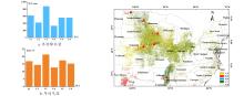
Fig. 1
Overview map of 6 representative regions in the United States

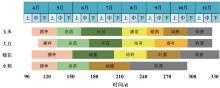
Fig. 2
Phenological calendar for major crops in 6 representative regions in the United States
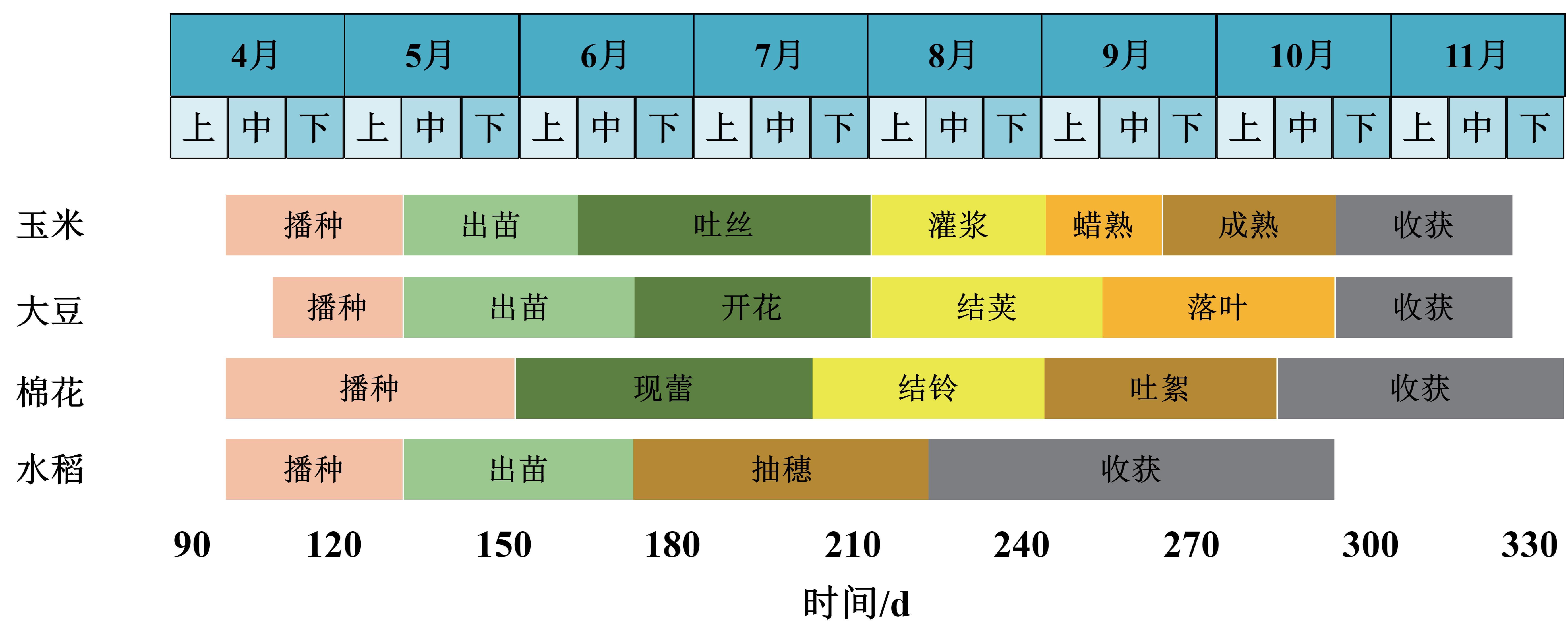
Table 1
Sentinel-2 data used for soybean remote sensing identification model across various locations from 2021 to 2023
| 地点 | 影像日期 | 影像数量/景 |
|---|---|---|
| 2021年8月24日 | 4 | |
| Dallas | 2022年9月13日 | 4 |
| 2023年8月22日 | 4 | |
| 2021年8月23日 | 4 | |
| Cass | 2022年8月30日 | 4 |
| 2023年8月25日 | 4 | |
| 2021年9月7日 | 4 | |
| Phillips | 2022年9月12日 | 4 |
| 2023年8月18日、8月21日 | 6 | |
| 2021年8月16日 | 4 | |
| Renville | 2022年8月14日 | 4 |
| 2023年8月29日 | 4 | |
| 2021年9月6日、9月9日 | 4 | |
| Bulter | 2022年8月30日 | 2 |
| 2023年8月22日、8月30日 | 4 | |
| 2021年9月16日、9月18日 | 8 | |
| Dodge | 2022年9月3日 | 4 |
| 2023年9月1日、9月3日 | 6 |
Table 2
Number of samples used at each location for constructing the soybean remote sensing identification model in 2022
| 地点 | 训练样本/个 | 验证样本/个 | ||
|---|---|---|---|---|
| 大豆 | 非大豆 | 大豆 | 非大豆 | |
| Dallas | 10 500 | 15 225 | 4 466 | 6 463 |
| Cass | 48 300 | 62 999 | 20 645 | 26 870 |
| Phillips | 16 612 | 11 550 | 8 919 | 4 916 |
| Renville | 7 800 | 46 199 | 3 271 | 19 629 |
| Bulter | 12 600 | 17 850 | 5 337 | 7 551 |
| Dodge | 9 450 | 15 748 | 3 980 | 6 586 |
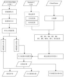
Fig. 3
Soybean field remote sensing identification technology process

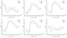
Fig. 4
Spectral wave time series curves for soybeans, corn, cotton, and rice

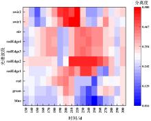
Fig. 5
Separation results of soybeans and other crops

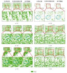
Fig. 6
Spatial details of soybean fields in typical regions in 2022

Table 3
Confusion matrix for soybean remote sensing identification models across locations in 2022
| 地点 | 类别 | 非大豆 | 大豆 | 总量 | 用户精度 |
|---|---|---|---|---|---|
| U1 | 非大豆 | 6 081 | 680 | 6 761 | 0.89 |
| 大豆 | 382 | 3 786 | 4 168 | 0.90 | |
| 总量 | 6 463 | 4 466 | 10 929 | — | |
| 生产者精度 | 0.94 | 0.85 | — | — | |
| 总体精度 | 0.90 | ||||
| Kappa | 0.79 | ||||
| U2 | 非大豆 | 24 751 | 2 887 | 27 638 | 0.89 |
| 大豆 | 2 119 | 17 758 | 19 877 | 0.89 | |
| 总量 | 26 870 | 20 645 | 47 515 | — | |
| 生产者精度 | 0.92 | 0.86 | — | — | |
| 总体精度 | 0.89 | ||||
| Kappa | 0.78 | ||||
| U3 | 非大豆 | 3 775 | 1 901 | 5 676 | 0.66 |
| 大豆 | 1 141 | 7 018 | 8 159 | 0.86 | |
| 总量 | 4 916 | 8 919 | 13 835 | — | |
| 生产者精度 | 0.76 | 0.78 | — | — | |
| 总体精度 | 0.78 | ||||
| Kappa | 0.70 | ||||
| U4 | 非大豆 | 19 087 | 933 | 20 020 | 0.95 |
| 大豆 | 542 | 2 338 | 2 880 | 0.81 | |
| 总量 | 19 629 | 3 271 | 22 900 | — | |
| 生产者精度 | 0.97 | 0.71 | — | — | |
| 总体精度 | 0.93 | ||||
| Kappa | 0.72 | ||||
| U5 | 非大豆 | 6 868 | 947 | 7 815 | 0.87 |
| 大豆 | 683 | 4 390 | 5 073 | 0.86 | |
| 总量 | 7 551 | 5 337 | 12 888 | — | |
| 生产者精度 | 0.90 | 0.82 | — | — | |
| 总体精度 | 0.87 | ||||
| Kappa | 0.73 | ||||
| U6 | 非大豆 | 6 202 | 326 | 6 528 | 0.95 |
| 大豆 | 384 | 3 654 | 4 038 | 0.90 | |
| 总量 | 6 586 | 3 980 | 10 566 | — | |
| 生产者精度 | 0.94 | 0.91 | — | — | |
| 总体精度 | 0.93 | ||||
| Kappa | 0.85 | ||||
Table 4
Confusion matrix for soybean remote sensing identification models in 2021
| 地点 | 类别 | 非大豆 | 大豆 | 总量 | 用户精度 |
|---|---|---|---|---|---|
| U1 | 非大豆 | 4 082 | 572 | 4 654 | 0.87 |
| 大豆 | 412 | 3 921 | 4 333 | 0.90 | |
| 总量 | 4 494 | 4 493 | 8 987 | — | |
| 生产者精度 | 0.90 | 0.87 | — | — | |
| 总体精度 | 0.89 | ||||
| Kappa | 0.78 | ||||
| U2 | 非大豆 | 19 609 | 2 992 | 22 601 | 0.86 |
| 大豆 | 2 891 | 17 258 | 20 149 | 0.85 | |
| 总量 | 22 500 | 20 250 | 42 750 | — | |
| 生产者精度 | 0.87 | 0.85 | — | — | |
| 总体精度 | 0.86 | ||||
| Kappa | 0.72 | ||||
| U3 | 非大豆 | 3 548 | 1 234 | 4 782 | 0.74 |
| 大豆 | 947 | 6 387 | 7 334 | 0.87 | |
| 总量 | 4 495 | 7 621 | 12 116 | — | |
| 生产者精度 | 0.78 | 0.83 | — | — | |
| 总体精度 | 0.82 | ||||
| Kappa | 0.68 | ||||
| U4 | 非大豆 | 21 856 | 1 436 | 23 292 | 0.93 |
| 大豆 | 2 444 | 12 064 | 14 508 | 0.83 | |
| 总量 | 24 300 | 13 500 | 37 800 | — | |
| 生产者精度 | 0.89 | 0.89 | — | — | |
| 总体精度 | 0.89 | ||||
| Kappa | 0.78 | ||||
| U5 | 非大豆 | 7 026 | 744 | 7 770 | 0.90 |
| 大豆 | 522 | 4 597 | 5 119 | 0.89 | |
| 总量 | 7 548 | 5 341 | 12 889 | — | |
| 生产者精度 | 0.93 | 0.86 | — | — | |
| 总体精度 | 0.90 | ||||
| Kappa | 0.79 | ||||
| U6 | 非大豆 | 5 372 | 451 | 5 823 | 0.92 |
| 大豆 | 276 | 3 910 | 4 186 | 0.93 | |
| 总量 | 5 648 | 4 361 | 10 009 | — | |
| 生产者精度 | 0.95 | 0.89 | — | — | |
| 总体精度 | 0.92 | ||||
| Kappa | 0.85 | ||||
Table 5
Confusion matrix for soybean remote sensing identification models in 2023
| 地点 | 类别 | 非大豆 | 大豆 | 总量 | 用户精度 |
|---|---|---|---|---|---|
| U1 | 非大豆 | 5 525 | 367 | 5 892 | 0.93 |
| 大豆 | 260 | 3 957 | 4 217 | 0.93 | |
| 总量 | 5 785 | 4 324 | 10 109 | — | |
| 生产者精度 | 0.95 | 0.91 | — | — | |
| 总体精度 | 0.93 | ||||
| Kappa | 0.87 | ||||
| U2 | 非大豆 | 20 954 | 3 204 | 24 158 | 0.86 |
| 大豆 | 2 806 | 16 099 | 18 905 | 0.85 | |
| 总量 | 23 760 | 19 303 | 43 063 | — | |
| 生产者精度 | 0.88 | 0.83 | — | — | |
| 总体精度 | 0.86 | ||||
| Kappa | 0.71 | ||||
| U3 | 非大豆 | 3 348 | 1 203 | 4 551 | 0.73 |
| 大豆 | 1 116 | 5 927 | 7 043 | 0.84 | |
| 总量 | 4 464 | 7 130 | 11 594 | — | |
| 生产者精度 | 0.75 | 0.83 | — | — | |
| 总体精度 | 0.80 | ||||
| Kappa | 0.71 | ||||
| U4 | 非大豆 | 15 932 | 1 516 | 17 448 | 0.91 |
| 大豆 | 1 022 | 2 269 | 3 291 | 0.68 | |
| 总量 | 16 954 | 3 785 | 20 739 | — | |
| 生产者精度 | 0.93 | 0.59 | — | — | |
| 总体精度 | 0.87 | ||||
| Kappa | 0.76 | ||||
| U5 | 非大豆 | 6 405 | 914 | 7 319 | 0.87 |
| 大豆 | 701 | 3 990 | 4 691 | 0.85 | |
| 总量 | 7 106 | 4 904 | 12 010 | — | |
| 生产者精度 | 0.90 | 0.81 | — | — | |
| 总体精度 | 0.86 | ||||
| Kappa | 0.77 | ||||
| U6 | 非大豆 | 5 358 | 534 | 5 892 | 0.90 |
| 大豆 | 397 | 3 142 | 3 539 | 0.88 | |
| 总量 | 5 755 | 3 676 | 9 431 | — | |
| 生产者精度 | 0.93 | 0.85 | — | — | |
| 总体精度 | 0.89 | ||||
| Kappa | 0.79 | ||||
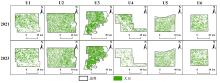
Fig. 7
Mapping results of the soybean identification model for 2021 and 2023
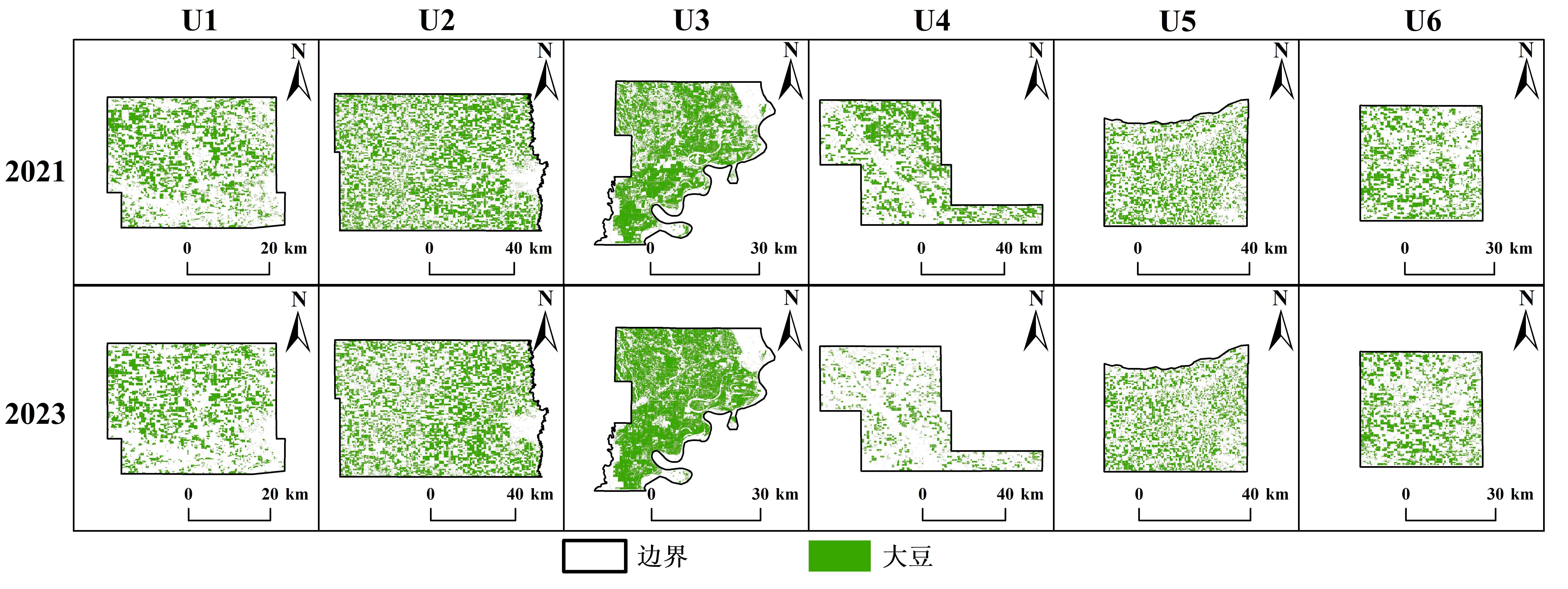
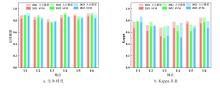
Fig. 8
Comparison of overall accuracy and Kappa coefficient between soybean identification model and SVM from 2021 to 2023

| [1] |
张锦华, 陈希. 中国食物分配特征与安全保障: 一个比较分析[J]. 中国农业大学学报(社会科学版), 2025, 42(4): 155-172.
|
|
|
|
| [2] |
刘璐璐, 李建飞, 舒跃, 等. 我国大豆生产消费现状及提升自给率策略[J]. 中国油料作物学报, 2022, 44(2): 242-248.
|
|
|
|
| [3] |
苗颖凤, 原野, 周正伟, 等. 汾渭平原农作物种植结构时空格局演变特征研究[J]. 干旱区地理, 2025, 48(6): 995-1005.
|
|
|
|
| [4] |
杨喆, 褚琳, 肖燚彬, 等. 2017—2021年东北地区主要粮食作物覆盖类型时空演变及其影响因素[J]. 资源科学, 2023, 45(5): 966-979.
|
|
|
|
| [5] |
潘耀忠, 李强子, 张锦水, 等. 主要农作物面积多维多尺度立体统计遥感调查技术研究进展[J]. 北京师范大学学报(自然科学版), 2025, 61(1): 118-125.
|
|
|
|
| [6] |
王利民, 刘佳, 姚保民, 等. 基于Rapideye数据的棉花特征光谱指数构建及类型识别[J]. 中国农业信息, 2019, 31(5): 25-37.
|
|
|
|
| [7] |
|
| [8] |
梁继, 郑镇炜, 夏诗婷, 等. 高分六号红边特征的农作物识别与评估[J]. 遥感学报, 2020, 24(10): 1168-1179.
|
|
|
|
| [9] |
黄双燕, 杨辽, 陈曦, 等. 机器学习法的干旱区典型农作物分类[J]. 光谱学与光谱分析, 2018, 38(10): 3169-3176.
|
|
|
|
| [10] |
鄂海林, 周德成, 李坤. 基于Sentinel 1/2和GEE的水稻种植面积提取方法: 以杭嘉湖平原为例[J]. 智慧农业(中英文), 2025, 7(2): 81-94.
|
|
|
|
| [11] |
屈炀, 袁占良, 赵文智, 等. 基于多时序特征和卷积神经网络的农作物分类[J]. 遥感技术与应用, 2021, 36(2): 304-313.
|
|
|
|
| [12] |
魏永康,杨天聪,丁信尧,等. 基于不同空间分辨率无人机多光谱遥感影像的小麦倒伏区域识别方法[J]. 智慧农业(中英文), 2023, 5 (2): 56-67.
|
|
|
|
| [13] |
牛朝阳, 高欧阳, 刘伟, 等. 光学遥感图像滑坡检测研究进展[J]. 航天返回与遥感, 2023, 44(3): 133-144.
|
|
|
|
| [14] |
张娟, 姚晓军, 陈进轩, 等. 基于无人机影像和深度学习技术的青海湖刚毛藻水华提取研究[J/OL]. 湖泊科学. (2025-06-11)[2025-07-12].
|
|
|
|
| [15] |
哈斯图亚, 陈仲新. 农业粮食体系数字转型期农业遥感研究进展与展望[J]. 遥感学报, 2025, 29(6): 1901-1917.
|
|
|
|
| [16] |
康兆庭, 杨田, 柴军, 等. 基于临床和放射特征的列线图非侵入性预测低级别胶质瘤患者的1p/19q染色体共缺失突变[J]. 中国CT和MRI杂志, 2023, 21(1): 18-21.
|
|
|
|
| [17] |
文刚, 高孟平, 高振宇, 等. 多因子协同作用下的云南省山火风险评估[J]. 广东电力, 2022, 35(4): 96-102.
|
|
|
|
| [18] |
张旷典, 郭孝玉, 康继, 等. 应用面向对象结合多时相哨兵-2A影像特征优选的毛竹林分布信息提取[J]. 东北林业大学学报, 2023, 51(1): 61-68, 87.
|
|
|
|
| [19] |
王晨, 褚琳, 杨喆, 等. 东北地区大豆单产空间分异特征及其影响因素分析[J]. 农业工程学报, 2023, 39(21): 108-119.
|
|
|
|
| [20] |
|
| [21] |
|
| [22] |
陈岱. 基于Logistic回归模型的大兴安岭林火预测研究[J]. 林业资源管理, 2019(1): 116-122.
|
|
|
|
| [23] |
刘威, 侯君, 唐龙泉, 等. 基于多中心的儿童颅脑创伤患者临床输血影响因素分析及预测模型构建[J]. 实用医学杂志, 2025, 41(4): 553-560.
|
|
|
|
| [24] |
邓元杰, 侯孟阳, 张晓, 等. 基于Logistic回归模型的陕西秦巴山区林地变化驱动力分析[J]. 南京林业大学学报(自然科学版), 2022, 46(1): 106-114.
|
|
|
|
| [25] |
沈宇, 李强子, 杜鑫, 等. 玉米大豆生长中后期遥感辨识的指示性特征研究[J]. 遥感学报, 2022, 26(7): 1410-1422.
|
|
|
|
| [26] |
|
| [27] |
刘佳, 王利民, 滕飞, 等. RapidEye卫星红边波段对农作物面积提取精度的影响[J]. 农业工程学报, 2016, 32(13): 140-148.
|
|
|
| [1] | SONG Mingxuan, BAI Bo, YANG Juntao, ZHANG Yutao, LI Sa, LI Zhenhai, WAN Shubo, LI Guowei. Robust UAV-Based Method for Peanut Plant Height Estimation Using Bare-Soil Invariant Constraints [J]. Smart Agriculture, 2025, 7(6): 124-135. |
| [2] | SUN Rong, GAO Han, JIANG Yujie, LI Qiaochu, WU Haoyu, WU Shangrong, YU Shan, XU Lei, YU Liangliang, ZHANG Jie, BAO Yuhai. Progress in Soil Moisture Retrieval under Crop Canopy Cover Based on Multi-polarization SAR Data [J]. Smart Agriculture, 2025, 7(6): 75-95. |
| [3] | ZHANG Yun, ZHANG Lumin, XU Guangtao, HAO Jiahui. Remote Sensing Extraction Method of Rice-Crayfish Fields Based on Dual-Branch and Multi-Scale Attention [J]. Smart Agriculture, 2025, 7(6): 185-195. |
| [4] | XIE Wenhao, ZHANG Xin, DONG Wen, ZHENG Yizhen, CHENG Bo, TU Wenli, SUN Fengqing. Parcel-Scale Crop Distribution Mapping Based on Stacking Ensemble Learning [J]. Smart Agriculture, 2025, 7(6): 196-209. |
| [5] | LU Yihang, DONG Wen, ZHANG Xin, YAN Ruoyi, ZHANG Yujia, TANG Tao. Physics-Constrained PROSAIL-cGAN Approach for Spectral Sample Augmentation and LAI Inversion of Winter Wheat [J]. Smart Agriculture, 2025, 7(6): 149-160. |
| [6] | LONG Yuqiao, SUN Jing, WEN Yanru, WANG Chuya, DONG Xiuchun, HUANG Ping, WU Wenbin, CHEN Jin, DING Mingzhong. Remote Sensing Approaches for Cropland Abandonment Perception in Southern Hilly and Mountainous Areas of China: A Review [J]. Smart Agriculture, 2025, 7(6): 58-74. |
| [7] | LI Fei, WANG Ziqiang, WU Jing, XIN Xia, LI Chunmei, XU Hubo. Imbalanced Hyperspectral Viability Detection of Naturally Aged Soybean Germplasm Based on Semi-Supervised Deep Convolutional Generative Adversarial Network [J]. Smart Agriculture, 2025, 7(5): 101-113. |
| [8] | LIU Jiajia, QIN Xiaojing, LI Qianchuan, XU Shiwei, ZHAO Jichun, WANG Yigang, XIONG Lu, LIANG Xiaohe. Forecasting Method for China's Soybean Demand Based on Improved Temporal Fusion Transformers [J]. Smart Agriculture, 2025, 7(4): 187-199. |
| [9] | LI Ruijie, WANG Aidong, WU Huaxing, LI Ziqiu, FENG Xiangqian, HONG Weiyuan, TANG Xuejun, QIN Jinhua, WANG Danying, CHU Guang, ZHANG Yunbo, CHEN Song. Remote Sensing for Rice Growth Stages Monitoring: Research Progress, Bottleneck Problems and Technical Optimization Paths [J]. Smart Agriculture, 2025, 7(3): 89-107. |
| [10] | MA Liu, MAO Kebiao, GUO Zhonghua. Defogging Remote Sensing Images Method Based on a Hybrid Attention-Based Generative Adversarial Network [J]. Smart Agriculture, 2025, 7(2): 172-182. |
| [11] | ZHAO Bingting, HUA Chuanhai, YE Chenyang, XIONG Yuchun, QIAN Tao, CHENG Tao, YAO Xia, ZHENG Hengbiao, ZHU Yan, CAO Weixing, JIANG Chongya. Research Progress on Remote Sensing Monitoring and Intelligent Decision-Making Algorithms for Rice Production [J]. Smart Agriculture, 2025, 7(2): 57-72. |
| [12] | E Hailin, ZHOU Decheng, LI Kun. Extracting Method of the Cultivation Aera of Rice Based on Sentinel-1/2 and Google Earth Engine (GEE): A Case Study of the Hangjiahu Plain [J]. Smart Agriculture, 2025, 7(2): 81-94. |
| [13] | MA Nan, CAO Shanshan, BAI Tao, KONG Fantao, SUN Wei. Research Progress and Prospect of Multi-robot Collaborative SLAM in Complex Agricultural Scenarios [J]. Smart Agriculture, 2024, 6(6): 23-43. |
| [14] | YAO Jianen, LIU Haiqiu, YANG Man, FENG Jinying, CHEN Xiu, ZHANG Peipei. Reconstruction of U.S. Regional-Scale Soybean SIF Based on MODIS Data and BP Neural Network [J]. Smart Agriculture, 2024, 6(5): 40-50. |
| [15] | CHEN Mingyou, LUO Lufeng, LIU Wei, WEI Huiling, WANG Jinhai, LU Qinghua, LUO Shaoming. Orchard-Wide Visual Perception and Autonomous Operation of Fruit Picking Robots: A Review [J]. Smart Agriculture, 2024, 6(5): 20-39. |
| Viewed | ||||||
|
Full text |
|
|||||
|
Abstract |
|
|||||


